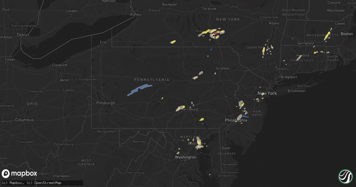
Hail Map in Pennsylvania on July 17, 2021
Get this storm
July 17 map
$229
one time, instant access
Download today. No call, no setup
Keep the $229
Bought the map and want the full workflow? Apply the entire $229 to a subscription within 7 days. None of it is wasted.
Every map, not just this one
This buys you this map. Subscription and you get every map we run, in the markets you choose from a few cities to whole states to nationwide. Plus real-time alerts the moment a storm fires.
Contact data
Name, contact info, occupancy, even credit band for addresses in the footprint. You go from where it hit to who to call.
Become the source they trust
Unlimited branding weather history reports on demand. You already have the documented answer ready for the property owner, and you are the one who showed up with it.
Property data and RoofTrace estimates
Pull up any address you have got, its value and the exact code rules for that jurisdiction, straight from One Click Code. Then RoofTrace estimates the squares, pitch, and roof value, priced the way you price.
Storm reports in Pennsylvania
Pennsylvania
| Date | Description |
|---|---|
| 07/17/20216:00 PM CDT | Several trees down and power outages. Time estimated from radar. |
| 07/17/20216:00 PM CDT | Trees down on devonshire road in west hanover township. |
| 07/17/20215:55 PM CDT | Several power outages reported in northeast philadelphia. Time estimated from radar. |
| 07/17/20215:31 PM CDT | Trees on wires. |
| 07/17/20215:30 PM CDT | Multiple trees down. |
| 07/17/20215:30 PM CDT | Large tree down on right lane of route 11 at cherry road. |
| 07/17/20215:28 PM CDT | Trees and wires down. Trees uprooted. |
| 07/17/20215:26 PM CDT | Trees down on highway 118. |
| 07/17/20215:23 PM CDT | Trees down at the intersection of route 42 and wintersteen school road. |
| 07/17/20215:21 PM CDT | Described as meatball sized hail. |
| 07/17/20215:16 PM CDT | Trees down in carroll valley and fairfield. |
| 07/17/20215:15 PM CDT | Corrects previous tstm wnd dmg report from 1 ne kulpmont. Trees on wires. |
| 07/17/20214:50 PM CDT | Tree on house. |
| 07/17/20214:45 PM CDT | Trees down along watts drive south of duncannon. |
| 07/17/20214:40 PM CDT | Tree on house. Power pole and wires down. |
| 07/17/20214:40 PM CDT | Part of a roof blown off of a barn on n ridge rd. |
| 07/17/20214:38 PM CDT | Tree down on a house. |
| 07/17/20214:13 PM CDT | Trees down on brewery hollow road. |
| 07/17/20214:10 PM CDT | Trees down on bellefonte avenue. |
| 07/17/20214:03 PM CDT | Trees down on monument orviston road in liberty township. |
| 07/17/20213:45 PM CDT | Tree and tree limb damage. |
| 07/17/20213:43 PM CDT | Trees on wires. |
| 07/17/20213:40 PM CDT | Multiple reports of trees on wires in the area. |
| 07/17/20213:35 PM CDT | A few trees down. |
| 07/17/20212:53 PM CDT | Storm damage reported on live incident list. |
| 07/17/20212:40 PM CDT | Trees down. |
| 07/17/20212:40 PM CDT | Large tree fell in wires on state route 481 near coyle curtain road. |
| 07/17/20212:38 PM CDT | Trees down blocking both lanes of lumber city road. |
| 07/17/20212:23 PM CDT | Trees down on moyers station road. |
| 07/17/20212:15 PM CDT | Trees and power lines down in northeastern indiana county |
| 07/17/20212:10 PM CDT | Some siding blown off a home. Time estimated from radar. |
| 07/17/20212:10 PM CDT | Large tree snapped. Time estimated from radar. |
| 07/17/20212:10 PM CDT | Several trees down in north catasaqua and catasauqua. Time estimated from radar. |
| 07/17/20212:01 PM CDT | Trees and power lines down across central indiana county. |
| 07/17/20212:00 PM CDT | Measured wind gust from the east from a microburst. A second gust of 57 mph occurred from the west a short time later. Trees and tree branches snapped nearby. |
| 07/17/20211:58 PM CDT | Trees down on wires in jackson township north of myerstown. |
| 07/17/20211:49 PM CDT | Multiple reports of trees and power lines down across white township. |
| 07/17/20211:48 PM CDT | Quarter-sized hail in bird-in-hand. Report via social media. |
| 07/17/20211:33 PM CDT | Tree damage in salem twp |
| 07/17/20211:11 PM CDT | Trees on wires. |
| 07/17/20211:07 PM CDT | Trees and wires down. |
| 07/17/20215:21 AM CDT | At 1021 PM EDT, severe thunderstorms were located along a line extending from Woodside to Bristol to Lumberton, moving east at 35 mph. HAZARD...60 mph wind gusts and quarter size hail. SOURCE...Radar indicated. IMPACT...Minor damage to vehicles is possible. Wind damage to roofs, siding, trees, and power lines is possible. Locations impacted include... Toms River, Trenton, Lakewood, Old Bridge, Jackson, Howell, East Brunswick, Marlboro, Manalapan, Ewing, Willingboro, Medford, Holmdel, Lumberton, Princeton, Florence, Burlington, Bristol, Mount Holly and Matawan.This includes the following highways... New Jersey Turnpike between exits 5 and 9. Pennsylvania Turnpike between mile markers 354 and 359. Interstate 95 in Pennsylvania between mile markers 37 and 40. Interstate 195 in New Jersey between mile markers 0 and 31. Interstate 295 in New Jersey between mile markers 43 and 76. Garden State Parkway between mile markers 118 and 122. |
| 07/17/20213:36 AM CDT | At 836 PM EDT, severe thunderstorms were located along a line extending from Princeton to Mount Holly, moving east at 25 mph. HAZARD...60 mph wind gusts. SOURCE...Radar indicated. IMPACT...Damage to roofs, siding, trees, and power lines is possible. Locations impacted include... Toms River, Trenton, New Brunswick, Perth Amboy, Somerset, Old Bridge, Jackson, East Brunswick, South Brunswick, Sayreville, North Brunswick, Marlboro, Manalapan, Princeton, Matawan, Jamesburg, Hightstown, Bordentown, Cranbury and Lakehurst.This includes the following highways... New Jersey Turnpike between exits 7 and 10. Interstate 195 in New Jersey between mile markers 0 and 27. Interstate 295 in New Jersey between mile markers 54 and 70. Garden State Parkway between mile markers 119 and 127. |
| 07/17/20213:00 AM CDT | At 759 PM EDT, severe thunderstorms were located along a line extending from Newtown to Erlton-Ellisburg, moving east at 45 mph. HAZARD...60 mph wind gusts and quarter size hail. SOURCE...Radar indicated. IMPACT...Minor damage to vehicles is possible. Wind damage to roofs, siding, trees, and power lines is possible. Locations impacted include... Philadelphia, Trenton, Camden, Gloucester City, Cherry Hill, Bensalem, Evesham, Mount Laurel, Ewing, Willingboro, Voorhees, Medford, Lindenwold, Lumberton, Florence, Bellmawr, Burlington, Bristol, Mount Holly and Riverside.This includes the following highways... New Jersey Turnpike between exits 3 and 8A. Pennsylvania Turnpike between mile markers 345 and 359. Interstate 95 in Pennsylvania between mile markers 24 and 40. Interstate 76 in New Jersey between mile markers 0 and 2. Interstate 195 in New Jersey between mile markers 0 and 11. Interstate 295 in New Jersey between mile markers 26 and 76. Interstate 676 in New Jersey between mile markers 0 and 4. |
| 07/17/20212:11 AM CDT | At 711 PM EDT, severe thunderstorms were located along a line extending from Carroll Valley to near Walkersville to near Green Valley, moving east at 40 mph. HAZARD...60 mph wind gusts. SOURCE...Radar indicated. IMPACT...Damaging winds will cause some trees and large branches to fall. This could injure those outdoors, as well as damage homes and vehicles. Roadways may become blocked by downed trees. Localized power outages are possible. Unsecured light objects may become projectiles. Locations impacted include... Frederick, Westminster, Thurmont, Emmitsburg, Eldersburg, Ballenger Creek, Mount Airy, Taneytown, Hampstead, Walkersville, Manchester, Sykesville, Oakland, New Market, Green Valley, Gamber, Discovery-Spring Garden, Linganore-Bartonsville, New Windsor and Woodsboro. |
| 07/17/20212:01 AM CDT | At 700 PM EDT, severe thunderstorms were located along a line extending from near Clinton to Gardenville, moving northeast at 20 mph. HAZARD...60 mph wind gusts. SOURCE...Radar indicated. IMPACT...Damage to roofs, siding, trees, and power lines is possible. Locations impacted include... Byram, Flemington, Tinicum, High Bridge, Clinton, Peapack And Gladstone, Glen Gardner, Frenchtown, Lebanon, Califon, Stockton, Sergeantsville, Pipersville, Erwinna, Annandale, Gardenville, White House Station, Lumberville and Sand Brook.This includes Interstate 78 in New Jersey between mile markers 13 and26. |
| 07/17/20211:51 AM CDT | At 650 PM EDT, a severe thunderstorm was located over Rockledge, or near Philadelphia, moving northeast at 35 mph. HAZARD...60 mph wind gusts. SOURCE...Radar indicated. IMPACT...Damage to roofs, siding, trees, and power lines is possible. Locations impacted include... Philadelphia, Bensalem, Florence, Burlington, Bristol, Palmyra, Hatboro, Jenkintown, Beverly, Rockledge, Newtown, Tullytown, Abington, Langhorne, Bryn Athyn, Wissinoming, Feasterville-Trevose, Willow Grove, Florence-Roebling and Germantown.This includes the following highways... Pennsylvania Turnpike between mile markers 343 and 359. Interstate 95 in Pennsylvania between mile markers 24 and 40. |
| 07/17/20211:39 AM CDT | At 639 PM EDT, severe thunderstorms were located along a line extending from near Little Meadows to near Montrose, moving northeast at 40 mph. HAZARD...60 mph wind gusts and quarter size hail. SOURCE...Radar indicated. IMPACT...Hail damage to vehicles is expected. Expect wind damage to roofs, siding, and trees. Locations impacted include... Binghamton, Vestal, Johnson City, Endicott, Kirkwood, Conklin, Sanford, Susquehanna, Deposit and Coventry. |
| 07/17/20211:39 AM CDT | At 639 PM EDT, a severe thunderstorm was located over Bridgewater, or over Somerville, moving east at 20 mph. HAZARD...60 mph wind gusts and quarter size hail. SOURCE...Radar indicated. IMPACT...Minor damage to vehicles is possible. Wind damage to roofs, siding, trees, and power lines is possible. Locations impacted include... Somerville, Somerset, Bridgewater, Middlesex, Princeton, Bound Brook, Manville, Flemington, Pennington, Peapack And Gladstone, New Hope, Hopewell, Far Hills, Rocky Hill, Stockton, Millstone, Skillman, Flagtown, Kingston and Belle Mead.This includes the following highways... Interstate 78 in New Jersey between mile markers 24 and 42. Interstate 287 in New Jersey between mile markers 6 and 28. |
| 07/17/20211:23 AM CDT | At 622 PM EDT, a severe thunderstorm was located over Ricketts Glen State Park, or 20 miles north of Berwick, moving northeast at 15 mph. HAZARD...60 mph wind gusts and quarter size hail. SOURCE...Radar indicated. IMPACT...Hail damage to vehicles is expected. Expect wind damage to roofs, siding, and trees. Locations impacted include... Vernon, Harveys Lake, Hollenback, Noxen, Mehoopany, Forkston, Laceyville, Kasson Brook, Evans Falls and Lovelton. |
| 07/17/20211:22 AM CDT | At 622 PM EDT, a severe thunderstorm was located near Biggertown, moving northeast at 45 mph. HAZARD...60 mph wind gusts and quarter size hail. SOURCE...Law enforcement. IMPACT...Hail damage to vehicles is expected. Expect wind damage to roofs, siding, and trees. Locations impacted include... Rohrsburg, Jamison City, Waller, Ricketts Glen State Park, Central, Biggertown, Muncy Valley, Benton, Dushore, Orangeville, Laporte, Stillwater, Forksville and Eagles Mere. |
| 07/17/20211:02 AM CDT | At 601 PM EDT, a severe thunderstorm was located over Flemington, or 15 miles southwest of Somerville, moving northeast at 15 mph. HAZARD...60 mph wind gusts and quarter size hail. SOURCE...Radar indicated. IMPACT...Minor damage to vehicles is possible. Wind damage to roofs, siding, trees, and power lines is possible. Locations impacted include... Somerville, Bridgewater, Byram, Bedminster, Flemington, Tinicum, High Bridge, Clinton, New Hope, Hopewell, Frenchtown, Lebanon, Stockton, Skillman, Flagtown, Belle Mead, Lumberville, Ottsville, Sergeantsville and Pipersville.This includes the following highways... Interstate 78 in New Jersey between mile markers 14 and 33. Interstate 287 in New Jersey between mile markers 17 and 21. |
| 07/17/202112:44 AM CDT | At 543 PM EDT, severe thunderstorms were located along a line extending from near Milton to near New Buffalo to near Newville, moving northeast at 30 mph. HAZARD...60 mph wind gusts and quarter size hail. SOURCE...Radar indicated. IMPACT...Hail damage to vehicles is expected. Expect wind damage to roofs, siding, and trees. Locations impacted include... Bloomsburg, Sunbury, Shamokin, Milton, Lewisburg, Selinsgrove, Danville, Northumberland, Kulpmont, Plainfield, Schlusser, Winfield, Millersburg, Marysville, Muncy, Watsontown, Elysburg, Fairview-Ferndale, Hughesville and Riverside.For those driving on Interstate 80, this includes areas between theMile Run and Berwick-Lime Ridge exits, specifically from mile markers208 to 237.This includes the following Interstates... The Pennsylvania Turnpike from mile markers 213 to 220. Interstate 180 from mile markers 1 to 12. |
| 07/17/202112:44 AM CDT | At 544 PM EDT, a severe thunderstorm was located over Boonsboro, or 7 miles east of Shepherdstown, moving northeast at 40 mph. HAZARD...60 mph wind gusts. SOURCE...Radar indicated. IMPACT...Damaging winds will cause some trees and large branches to fall. This could injure those outdoors, as well as damage homes and vehicles. Roadways may become blocked by downed trees. Localized power outages are possible. Unsecured light objects may become projectiles. Locations impacted include... Thurmont, Emmitsburg, Boonsboro, Mount Aetna, Mount Lena, San Mar, Wolfsville, Myersville, Keedysville, Woodsboro, Union Bridge, Sharpsburg, Sabillasville, Rohrersville, Gapland, New Midway, Utica, Bolivar, Keysville and Graceham. |
| 07/17/202112:35 AM CDT | At 534 PM EDT, a severe thunderstorm was located over Beaumont, or 10 miles west of Pittston, moving north at 20 mph. HAZARD...60 mph wind gusts and quarter size hail. SOURCE...Radar indicated. IMPACT...Hail damage to vehicles is expected. Expect wind damage to roofs, siding, and trees. Locations impacted include... Falls, Vernon, Swoyersville, Forty Fort, Lehman, Luzerne, Dallas, Harveys Lake, West Wyoming and Tunkhannock. |
| 07/17/202112:30 AM CDT | At 529 PM EDT, a severe thunderstorm was located over Erwinna, or 14 miles southeast of Easton, moving northeast at 40 mph. HAZARD...60 mph wind gusts and quarter size hail. SOURCE...Radar indicated. IMPACT...Minor damage to vehicles is possible. Wind damage to roofs, siding, trees, and power lines is possible. Locations impacted include... Byram, Bedminster, Washington, Tinicum, High Bridge, Clinton, Alpha, Glen Gardner, Ferndale, Hampton, Frenchtown, Milford, Bloomsbury, Riegelsville, Pleasant Valley, Revere, Ottsville, Pipersville, Erwinna and Annandale.This includes Interstate 78 in New Jersey between mile markers 2 and19. |
| 07/17/202112:28 AM CDT | At 527 PM EDT, a severe thunderstorm was located over Clarks Summit, or over Waverly, moving northeast at 30 mph. HAZARD...60 mph wind gusts and quarter size hail. SOURCE...Radar indicated. IMPACT...Hail damage to vehicles is expected. Expect wind damage to roofs, siding, and trees. Locations impacted include... Scranton, Falls, Archbald, Blakely, Taylor, Dickson City, Clarks Summit, Throop, Jackson and Clifford. |
| 07/17/202112:02 AM CDT | At 502 PM EDT, severe thunderstorms were located along a line extending from near Monument to near Blanchard to near Lamar, moving east at 40 mph. HAZARD...60 mph wind gusts. SOURCE...Radar indicated. IMPACT...Expect damage to roofs, siding, and trees. Locations impacted include... Williamsport, Lock Haven, Jersey Shore, Carroll, Lamar, Mill Hall, Avis, Dunnstown, Flemington, Duboistown, Castanea, McElhattan, Monument, Elimsport, Cogan Station, Collomsville, Mackeyville, South Williamsport, Garden View and Beech Creek.For those driving on Interstate 80, this includes areas between theBellefonte and Mile Run exits, specifically from mile markers 171 to194.This includes Interstate 180 from mile markers 24 to 29. |
| 07/16/202111:55 PM CDT | At 455 PM EDT, a severe thunderstorm was located over Sergeantsville, or 18 miles northwest of Trenton, moving northeast at 20 mph. HAZARD...60 mph wind gusts and quarter size hail. SOURCE...Radar indicated. IMPACT...Minor damage to vehicles is possible. Wind damage to roofs, siding, trees, and power lines is possible. Locations impacted include... Flemington, High Bridge, Clinton, Peapack And Gladstone, Glen Gardner, Lebanon, Califon, Far Hills, Sergeantsville, Cloverhill, Annandale, White House Station, Sand Brook and Bernardsville.This includes the following highways... Interstate 78 in New Jersey between mile markers 13 and 30. Interstate 287 in New Jersey between mile markers 22 and 23. |
| 07/16/202111:50 PM CDT | At 450 PM EDT, severe thunderstorms were located along a line extending from Weikert to near Mcalisterville, moving northeast at 35 mph. HAZARD...60 mph wind gusts. SOURCE...Radar indicated. IMPACT...Expect damage to roofs, siding, and trees. Locations impacted include... Sunbury, Milton, Lewisburg, Selinsgrove, Northumberland, Mifflinburg, Winfield, Watsontown, Shamokin Dam, Linntown, Hummels Wharf, Middleburg, New Columbia, Mcalisterville, McClure, Montandon, Kreamer, Port Trevorton, Penns Creek and Beaver Springs.For those driving on Interstate 80, this includes areas between theJersey Shore and Danville exits, specifically from mile markers 196to 216.This includes Interstate 180 from mile markers 1 to 8. |
| 07/16/202111:05 PM CDT | At 405 PM EDT, severe thunderstorms were located along a line extending from near Allensville to near Rockhill Furnace, moving northeast at 30 mph. HAZARD...60 mph wind gusts. SOURCE...Radar indicated. IMPACT...Expect damage to roofs, siding, and trees. Locations impacted include... Lewistown, Woodward, Mount Union, Burnham, Belleville, Milroy, Highland Park, Honey Grove, Yeagertown, Millheim, Spruce Hill, Strodes Mills, Reedsville, Aaronsburg, Juniata Terrace, Allensville, Mexico, Coburn, East Waterford and Alfarata. |
| 07/16/202110:52 PM CDT | At 352 PM EDT, severe thunderstorms were located along a line extending from Plymptonville to Jeffries to near Blandburg, moving northeast at 45 mph. HAZARD...60 mph wind gusts. SOURCE...Radar indicated. IMPACT...Expect damage to roofs, siding, and trees. Locations impacted include... Clearfield, Philipsburg, Woodland, Curwensville, Stormstown, Hyde, Osceola Mills, Plymptonville, Chester Hill, Karthaus, Houtzdale, Snow Shoe, North Philipsburg, Clarence, Port Matilda, South Philipsburg, Sandy Ridge, Moshannon, Pine Glen and Jeffries.For those driving on Interstate 80, this includes areas between thePenfield and Milesburg exits, specifically from mile markers 114 to147.This includes Interstate 99 from mile markers 59 to 66. |
| 07/16/202110:14 PM CDT | At 314 PM EDT, a severe thunderstorm was located over Smithville, moving northeast at 15 mph. HAZARD...60 mph wind gusts and quarter size hail. SOURCE...Radar indicated. IMPACT...Hail damage to vehicles is expected. Expect wind damage to roofs, siding, and trees. Locations impacted include... Lancaster, Willow Street, New Holland, Leola, Paradise, Strasburg, Quarryville, Gap, Leacock, Bareville, Smithville, Lampeter, Intercourse, Conestoga, Christiana, Georgetown, Gordonville, Bird-In-Hand, Smoketown and Refton. |
| 07/16/202110:04 PM CDT | At 304 PM EDT, severe thunderstorms were located along a line extending from near Punxsutawney to near Homer City to near Westmont to Acosta, moving northeast at 35 mph. HAZARD...60 mph wind gusts. SOURCE...Radar indicated. IMPACT...Expect damage to roofs, siding, and trees. Locations impacted include... Johnstown, DuBois, Somerset, Clearfield, Westmont, Windber, Ebensburg, Belmont, Nanty-Glo, Portage, Sandy, Northern Cambria, Woodland, Curwensville, Geistown, Southmont, Patton, Cresson, Gallitzin and Friedens.For those driving on Interstate 80, this includes areas between theDubois and Kylertown exits, specifically from mile markers 100 to124.This includes The Pennsylvania Turnpike from mile markers 101 to 110. |
| 07/16/202110:02 PM CDT | At 302 PM EDT, a severe thunderstorm was located over Fredericksburg, moving northeast at 15 mph. HAZARD...60 mph wind gusts and quarter size hail. SOURCE...Radar indicated. IMPACT...Hail damage to vehicles is expected. Expect wind damage to roofs, siding, and trees. Locations impacted include... Pine Grove, Tremont, Fredericksburg, Donaldson, Lickdale, Jonestown, Hegins, Ravine, Muir and Orwin.This includes the following Interstates... Interstate 78 from mile markers 1 to 8. Interstate 81 from mile markers 90 to 112. |
| 07/16/20219:52 PM CDT | At 251 PM EDT, a severe thunderstorm was located near Pine Grove, moving north at 25 mph. HAZARD...60 mph wind gusts and quarter size hail. SOURCE...Radar indicated. IMPACT...Hail damage to vehicles is expected. Expect wind damage to roofs, siding, and trees. Locations impacted include... Pottsville, Schuylkill Haven, Minersville, St. Clair, Orwigsburg, Pine Grove, Port Carbon, Tremont, New Philadelphia, Friedensburg, Marlin, Renningers, Forrestville, Branchdale, Seltzer, Heckscherville, Buck Run, Beurys Lake, Lake Wynonah and Cressona.This includes Interstate 81 from mile markers 113 to 120. |
| 07/16/20219:51 PM CDT | At 251 PM EDT, a severe thunderstorm was located near Indiana, moving east at 40 mph. HAZARD...Wind gusts to 60 mph. SOURCE...Radar. IMPACT...Expect damage to trees and power lines, resulting in some power outages. Locations impacted include... Indiana... Clymer... Chevy Chase Heights... Ernest... Marion Center... Cherry Tree... Glen Campbell... Dixonville... Commodore... |
| 07/16/20219:36 PM CDT | At 235 PM EDT, a severe thunderstorm was located over Myerstown, moving northeast at 25 mph. HAZARD...60 mph wind gusts and quarter size hail. SOURCE...Radar indicated. Downed trees were also reported with this storm in Lebanon County. IMPACT...Minor damage to vehicles is possible. Wind damage to roofs, siding, trees, and power lines is possible. Locations impacted include... Hamburg, Womelsdorf, Bernville and Strausstown. This includes Interstate 78 in Pennsylvania between mile markers 10and 31. |
| 07/16/20219:30 PM CDT | At 230 PM EDT, a severe thunderstorm was located over Greensburg, moving east at 35 mph. HAZARD...Wind gusts to 60 mph. SOURCE...Radar. IMPACT...Expect damage to trees and power lines, resulting in some power outages. Locations impacted include... Greensburg... Indiana... Jeannette... Latrobe... Homer City... McChesneytown-Loyalhanna... Blairsville... Youngwood... Derry... Delmont... Lawson Heights... New Stanton...This includes the following highways... Interstate 70 in Pennsylvania between mile markers 56 and 57. Pennsylvania Turnpike between mile markers 69 and 76. |
| 07/16/20219:29 PM CDT | At 228 PM EDT, a severe thunderstorm was located over Millersville, moving east at 20 mph. HAZARD...60 mph wind gusts and quarter size hail. SOURCE...Radar indicated. IMPACT...Hail damage to vehicles is expected. Expect wind damage to roofs, siding, and trees. Locations impacted include... Lancaster, Ephrata, Millersville, Willow Street, New Holland, Akron, Leola, Paradise, Strasburg, Leacock, Bareville, Smithville, Safe Harbor, Lampeter, Intercourse, Conestoga, Georgetown, Farmersville, Gordonville and Bird-In-Hand. |
| 07/16/20219:13 PM CDT | At 213 PM EDT, a severe thunderstorm was located over Cornwall, moving northeast at 35 mph. HAZARD...60 mph wind gusts and quarter size hail. SOURCE...Radar indicated. IMPACT...Hail damage to vehicles is expected. Expect wind damage to roofs, siding, and trees. Locations impacted include... Lebanon, Cornwall, Myerstown, Newmanstown, Lebanon South, Avon, Richland, Schaefferstown, Quentin, Mount Gretna Heights, Kleinfeltersville, Penryn, Mount Gretna and Avon Heights.This includes The Pennsylvania Turnpike from mile markers 265 to 273. |
| 07/16/20219:05 PM CDT | Report from mping: trees uprooted or snapped; time estimated from radar. |
| 07/16/20219:04 PM CDT | At 203 PM EDT, a severe thunderstorm was located over Whitesville, or 12 miles southeast of Wellsville, moving east at 30 mph. HAZARD...60 mph wind gusts. SOURCE...Radar indicated. IMPACT...Expect damage to roofs, siding, and trees. Locations impacted include... Woodhull, Jasper, Troupsburg, Cameron, Greenwood, West Cameron, Willeyville, Young Hickory and West Greenwood. |
| 07/16/20218:56 PM CDT | At 155 PM EDT, a severe thunderstorm was located over Clinton, or 15 miles west of Somerville, moving northeast at 20 mph. HAZARD...60 mph wind gusts and quarter size hail. SOURCE...Trained weather spotters. Downed trees and power outages were reported with this cell over eastern Pennsylvania. IMPACT...Minor damage to vehicles is possible. Wind damage to roofs, siding, trees, and power lines is possible. Locations impacted include... Somerville, Bridgewater, Middlesex, Bound Brook, Manville, Hackettstown, Washington, Flemington, High Bridge, Clinton, Peapack And Gladstone, Glen Gardner, Chester, Hampton, Frenchtown, Lebanon, Milford, Califon, Far Hills and Stockton.This includes the following highways... Interstate 78 in New Jersey between mile markers 10 and 40. Interstate 287 in New Jersey between mile markers 13 and 28. |
| 07/16/20218:48 PM CDT | At 147 PM EDT, severe thunderstorms were located along a line extending from near Mount Joy to near Windsor, moving east at 15 mph. HAZARD...60 mph wind gusts and quarter size hail. SOURCE...Radar indicated. IMPACT...Hail damage to vehicles is expected. Expect wind damage to roofs, siding, and trees. Locations impacted include... Lancaster, Columbia, Lititz, Millersville, Willow Street, Mount Joy, Manheim, East Petersburg, Akron, Leola, Salunga-Landisville, Rothsville, Strasburg, Mountville, Marietta, Wrightsville, Windsor, Brickerville, Yorkana and Leacock.This includes The Pennsylvania Turnpike from mile markers 273 to 278. |
| 07/16/20218:32 PM CDT | Tree down blocking the road on round hill rd at kaoli rd. Time estimated from radar and dispatch report. |
| 07/16/20218:29 PM CDT | Tree limbs blocking the road on kaolin rd at limestone rd. Time estimated from radar and dispatch report. |
| 07/16/20218:05 PM CDT | At 105 PM EDT, a severe thunderstorm was located over Gardenville, or 19 miles northwest of Trenton, moving northeast at 10 mph. HAZARD...60 mph wind gusts and quarter size hail. SOURCE...Radar indicated. IMPACT...Minor damage to vehicles is possible. Wind damage to roofs, siding, trees, and power lines is possible. Locations impacted include... Princeton, Doylestown, Byram, Flemington, Tinicum, Clinton, Pennington, New Hope, Hopewell, Stockton, Sergeantsville, Gardenville, Lumberville, Sand Brook and Lambertville.This includes Interstate 78 in New Jersey between mile markers 16 and17. |
| 07/16/20217:15 PM CDT | Tree down. |
| 07/16/20217:08 PM CDT | Several power outages. Large branches blown down and siding blown off a house. Spotter estimated winds above 60 mph. Time estimated from radar. |
All States Impacted by Hail Map on July 17, 2021
Cities Impacted by Hail Map on July 17, 2021
- Lincoln, RI
- Harrisburg, PA
- Dalhart, TX
- Westhope, ND
- Souris, ND
- Atwood, CO
- Merino, CO
- Sterling, CO
- Boone, CO
- Fowler, CO
- Goodwell, OK
- Edgemont, SD
- Stone Ridge, NY
- Hurley, NY
- West Hurley, NY
- Kingston, NY
- Johnstown, NE
- Newtown, PA
- Langhorne, PA
- Lambertville, NJ
- Philadelphia, PA
- Muncy, PA
- Turbotville, PA
- Newark, NJ
- Elizabeth, NJ
- Potomac, MD
- Reston, VA
- Great Falls, VA
- Herndon, VA
- Leesville, SC
- Clarendon, TX
- Claude, TX
- Airville, PA
- Brogue, PA
- Rhinebeck, NY
- Red Hook, NY
- Cheney, KS
- Bloomsburg, PA
- Millville, PA
- Danville, PA
- South Haven, KS
- Geuda Springs, KS
- Rural Hall, NC
- Oxford, NY
- New Paltz, NY
- Clovis, NM
- Las Animas, CO
- Isabella, OK
- Fairview, OK
- Arnett, OK
- Whitney Point, NY
- Saint Petersburg, FL
- Seminole, FL
- Pinellas Park, FL
- Stratford, TX
- Panhandle, TX
- Deer Trail, CO
- Stilwell, OK
- Berlin, MA
- West Boylston, MA
- Boylston, MA
- Worcester, MA
- Shrewsbury, MA
- Clinton, MA
- Kingman, KS
- Vega, TX
- Brush, CO
- Canon City, CO
- Melrose, NM
- Hereford, TX
- Wildorado, TX
- Sykesville, MD
- Marriottsville, MD
- Lead, SD
- Amarillo, TX
- Rembert, SC
- Purdum, NE
- Canyon, TX
- Wiggins, CO
- Mount Airy, MD
- Carlisle, PA
- Shermans Dale, PA
- Landisburg, PA
- Newville, PA
- Humansville, MO
- Bolivar, MO
- Dunnegan, MO
- Salt Point, NY
- Hyde Park, NY
- Mebane, NC
- Burlington, NC
- Cedar Grove, NC
- Marysville, PA
- Duncannon, PA
- Jasper, NY
- Woodhull, NY
- Addison, NY
- Greenwood, NY
- Cameron Mills, NY
- Canadian, TX
- Fort Morgan, CO
- Turon, KS
- Miami, TX
- Mobeetie, TX
- Custer, SD
- Orange, VA
- Crook, CO
- Peetz, CO
- Denham Springs, LA
- Portales, NM
- Mayesville, SC
- Gable, SC
- Sumter, SC
- Evening Shade, AR
- Lincoln, AR
- Canehill, AR
- Evansville, AR
- Cunningham, KS
- Brule, NE
- Burlington, NJ
- Louisa, VA
- Gordonsville, VA
- Saint Pauls, NC
- Blackstone, VA
- McKenney, VA
- Reidsville, NC
- Muncy Valley, PA
- Benton, PA
- Unityville, PA
- Auburn, MA
- Newark Valley, NY
- Cincinnatus, NY
- Dryden, NY
- Greene, NY
- Slaterville Springs, NY
- Binghamton, NY
- Berkshire, NY
- Lisle, NY
- Richford, NY
- Ithaca, NY
- Newfield, NY
- Marathon, NY
- Willet, NY
- Maine, NY
- Willseyville, NY
- Glen Aubrey, NY
- Smithville Flats, NY
- Harford, NY
- Spencer, NY
- McDonough, NY
- Brooktondale, NY
- Hendersonville, NC
- Black Mountain, NC
- Washington Boro, PA
- Lancaster, PA
- Conestoga, PA
- Millersville, PA
- Elon, NC
- Browns Summit, NC
- McLeansville, NC
- Greensboro, NC
- Gibsonville, NC
- Ridgeland, SC
- Dundalk, MD
- Rosedale, MD
- Essex, MD
- Baltimore, MD
- Bottineau, ND
- Halifax, PA
- Willington, CT
- Ashford, CT
- Storrs Mansfield, CT
- San Jon, NM
- Calhan, CO
- Parkville, MD
- Lake Lure, NC
- Columbia, VA
- Kents Store, VA
- Baker, MT
- Camp Crook, SD
- Buffalo, SD
- Florissant, CO
- Ford, VA
- Amelia Court House, VA
- Lecompte, LA
- Snyder, CO
- Lisco, NE
- Rockland, ID
- American Falls, ID
- Pampa, TX
- Warrenton, VA
- Broad Run, VA
- Otis, MA
- Rantoul, KS
- Torrington, WY
- Cherry Valley, MA
- Pritchett, CO
- Hugo, CO
- Limon, CO
- New Port Richey, FL
- Sudan, TX
- Fairfield, NJ
- Caldwell, NJ
- Little Falls, NJ
- Cedar Grove, NJ
- Wayne, NJ
- Lexington, NC
- Seymour, TX
- Tulsa, OK
- Antler, ND
- Fairfax, OK
- Charles City, VA
- Henrico, VA
- Providence Forge, VA
- Quinton, VA
- Sandston, VA
- Coward, SC
- North Grafton, MA
- High Falls, NY
- Cottekill, NY
- Summerfield, NC
- Springfield, CO
- Hudson, KS
- Havana, KS
- Niotaze, KS
- Clayton, NM
- Cameron, NY
- Williamsburg, VA
- Lynchburg, VA
- Rustburg, VA
- Columbia, SC
- Lake Katrine, NY
- Saugerties, NY
- Titusville, NJ
- Trenton, NJ
- South Hill, VA
- Kenbridge, VA
- Murdock, KS
- Groom, TX
- Colorado Springs, CO
- Sylvia, KS
- St John, KS
- Stockville, NE
- New Hope, PA
- Stockton, NJ
- Ringoes, NJ
- Winston Salem, NC
- Pfafftown, NC
- Alma, GA
- Danville, VA
- Oldsmar, FL
- Dunning, NE
- Florence, NJ
- Levittown, PA
- Morrisville, PA
- Fairless Hills, PA
- Bristol, PA
- Peyton, CO
- Chenango Forks, NY
- Yanceyville, NC
- Troupsburg, NY
- Quanah, TX
- Happy, TX
- Bois D Arc, MO
- Willard, MO
- Ash Grove, MO
- Springfield, MO
- Rowesville, SC
- Wheeler, TX
- Vernon, TX
- Hillrose, CO
- Okeene, OK
- Benson, NC
- Angier, NC
- Lovington, NM
- Roswell, NM
- Madrid, NE
- Carmel, NY
- Wibaux, MT
- Sherwood, ND
- Plevna, KS
- Abbyville, KS
- Carthage, NC
- Vass, NC
- Mansfield Center, CT
- Newkirk, OK
- Huntingdon, PA
- Hot Springs, SD
- Lumberton, NC
- Baton Rouge, LA
- Prairieville, LA
- Broken Arrow, OK
- Grandfield, OK
- Dayville, CT
- Pomfret Center, CT
- Broadview, NM
- Staten Island, NY
- Baxley, GA
- Furlong, PA
- Frenchtown, NJ
- Flemington, NJ
- Lumberville, PA
- Doylestown, PA
- Carversville, PA
- Conover, NC
- Olar, SC
- Ehrhardt, SC
- Mohall, ND
- Eldorado, OK
- Elizabethport, NJ
- Pierce City, MO
- Granby, MO
- Lewisville, NC
- Harrison, NE
- Stafford Springs, CT
- Roxbury, CT
- Southbury, CT
- Palmyra, NJ
- Merchantville, NJ
- Camden, NJ
- Riverton, NJ
- Bensalem, PA
- Pennsauken, NJ
- Riverside, NJ
- Beverly, NJ
- Kirk, CO
- New Britain, CT
- Newington, CT
- Bristol, CT
- Southington, CT
- Plainville, CT
- West Hartford, CT
- Farmington, CT
- Grant, NE
- Glen Burnie, MD
- Curtis Bay, MD
- Sparrows Point, MD
- Fleming, CO
- Jeffersonton, VA
- Remington, VA
- Ruffin, NC
- Pelham, NC
- Gallion, AL
- Faunsdale, AL
- Piscataway, NJ
- Pollock, LA
- Woodstock, NY
- Byers, CO
- Dunseith, ND
- Swansea, SC
- Chestertown, MD
- Towson, MD
- Nottingham, MD
- North Scituate, RI
- Chepachet, RI
- Foster, RI
- East Killingly, CT
- Ellicott City, MD
- Windsor Mill, MD
- Alexandria, LA
- Fort Howard, MD
- Castle Creek, NY
- Middle River, MD
- Glen Arm, MD
- Brooklyn, MD
- Cockeysville, MD
- Millersville, MD
- Perry Hall, MD
- Pasadena, MD
- Phoenix, MD
- Lutherville Timonium, MD
- Tivoli, NY
- Washington Depot, CT
- New Milford, CT
- Port Ewen, NY
- Stevensville, PA
- Wyalusing, PA
- Laceyville, PA
- Maxwell, NE
- Bennett, CO
- Scranton, SC
- Timmonsville, SC
- Dry Prong, LA
- Colfax, LA
- Bentley, LA
- Candor, NY
- Cape Fair, MO
- Bamberg, SC
- Garden Plain, KS
- Milton, KS
- Viola, KS
- Metuchen, NJ
- Fords, NJ
- Iselin, NJ
- South Plainfield, NJ
- Edison, NJ
- Alden, KS
- Wedgefield, SC
- Paducah, TX
- Front Royal, VA
- White Post, VA
- Boyce, VA
- Manning, SC
- Hartley, TX
- Hardeeville, SC
- Okarche, OK
- Whitehall, PA
- Allentown, PA
- Clearwater, FL
- Dunedin, FL
- Orangeburg, SC
- Wagon Mound, NM
- Sutton, MA
- Oxford, MA
- Millbury, MA
- Church Creek, MD
- Cambridge, MD
- Dover, DE
- Neosho, MO
- Jeffersonville, NY
- Fort Cobb, OK
- Arlington, KS
- Lyons, GA
- Hartsville, SC
- Lance Creek, WY
- Rochdale, MA
- Northborough, MA
- Leicester, MA
- Kingston, PA
- Luzerne, PA
- Wilkes Barre, PA
- Plymouth, PA
- Booker, TX
- Red Lion, PA
- Wrightsville, PA
- Windsor, PA
- Gadsden, SC
- Staatsburg, NY
- Bristol, FL
- Voorhees, NJ
- Marlton, NJ
- Cherry Hill, NJ
- Mcalister, NM
- Palmyra, VA
- Pretty Prairie, KS
- Ruckersville, VA
- Earlysville, VA
- Charlottesville, VA
- Dyke, VA
- Owings Mills, MD
- Stevenson, MD
- Pikesville, MD
- Germantown, MD
- Gaithersburg, MD
- Bolton, MA
- Harvard, MA
- Devens, MA
- Lancaster, MA
- Friona, TX
- Bowman, SC
- Catskill, NY
- Lane, KS
- Osawatomie, KS
- Brunson, SC
- Melbourne, AR
- Endicott, NY
- Haven, KS
- Keasbey, NJ
- Sayreville, NJ
- South Amboy, NJ
- Danbury, NC
- Lawsonville, NC
- Bennettsville, SC
- Wallace, SC
- Highland, NY
- Ulster Park, NY
- Cameron, NC
- Gaston, SC
- West Columbia, SC
- Shell Knob, MO
- Lampe, MO
- Hale Center, TX
- Plainview, TX
- Olanta, PA
- Clearfield, PA
- Curwensville, PA
- Clymer, PA
- Dixonville, PA
- New Millport, PA
- Osceola Mills, PA
- Houtzdale, PA
- Glen Campbell, PA
- Philipsburg, PA
- Hillsdale, PA
- Arcadia, PA
- Mahaffey, PA
- Marion Center, PA
- Commodore, PA
- Cherry Tree, PA
- Gipsy, PA
- Indiana, PA
- West Decatur, PA
- Glen Richey, PA
- Irvona, PA
- La Jose, PA
- Ernest, PA
- Rochester Mills, PA
- Little Meadows, PA
- Friendsville, PA
- Summerfield, TX
- Willingboro, NJ
- Columbus, NJ
- Bordentown, NJ
- Jobstown, NJ
- Mount Holly, NJ
- Fallon, MT
- Freeville, NY


