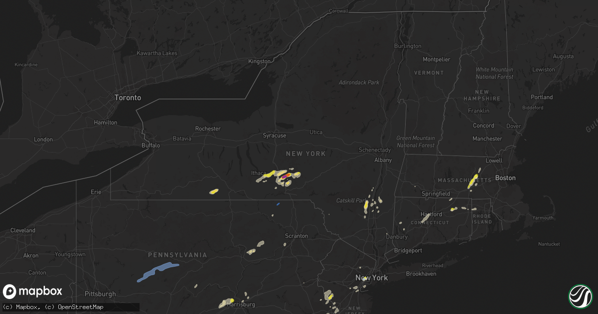
Hail Map in New York on July 17, 2021
Get this storm
July 17 map
$229
one time, instant access
Download today. No call, no setup
Keep the $229
Bought the map and want the full workflow? Apply the entire $229 to a subscription within 7 days. None of it is wasted.
Every map, not just this one
This buys you this map. Subscription and you get every map we run, in the markets you choose from a few cities to whole states to nationwide. Plus real-time alerts the moment a storm fires.
Contact data
Name, contact info, occupancy, even credit band for addresses in the footprint. You go from where it hit to who to call.
Become the source they trust
Unlimited branding weather history reports on demand. You already have the documented answer ready for the property owner, and you are the one who showed up with it.
Property data and RoofTrace estimates
Pull up any address you have got, its value and the exact code rules for that jurisdiction, straight from One Click Code. Then RoofTrace estimates the squares, pitch, and roof value, priced the way you price.
Storm reports in New York
New York
| Date | Description |
|---|---|
| 07/17/20216:09 PM CDT | Tree down on road. Time estimated by radar. |
| 07/17/20216:06 PM CDT | Tree down on road. Time estimated by radar. |
| 07/17/20215:45 PM CDT | Tree and wires down. Time estimated by radar. |
| 07/17/20215:26 PM CDT | Road closed due to a downed tree near hwy 9j and cr26a. |
| 07/17/20215:25 PM CDT | Tree down blocking road. Time estimated by radar. |
| 07/17/20215:20 PM CDT | Tree down blocking both lanes. Time estimated by radar. |
| 07/17/20214:54 PM CDT | Tree down on road. Time estimated by radar. |
| 07/17/20214:35 PM CDT | A local report indicates 2.00 inch wind near 2 N WHITNEY POINT |
| 07/17/20214:32 PM CDT | Power pole and wires downed on rowe road |
| 07/17/20214:21 PM CDT | Trees and wires down on road. Time estimated by radar. |
| 07/17/20214:15 PM CDT | A local report indicates 1.00 inch wind near 2 SE HARFORD |
| 07/17/20214:10 PM CDT | A tree down that closed route 375. |
| 07/17/20214:06 PM CDT | Trees down and roof damage at a mobile home park. Time estimated by radar. |
| 07/17/20214:06 PM CDT | Quarter sized hail reported on lapla road |
| 07/17/20214:06 PM CDT | Trees and wires down. Time estimated by radar. |
| 07/17/20214:00 PM CDT | A local report indicates 1.00 inch wind near 1 SE HARFORD |
| 07/17/20214:00 PM CDT | Estimated by picture. Time estimated by radar. |
| 07/17/20213:55 PM CDT | Tree downed on leggett road |
| 07/17/20213:45 PM CDT | Large tree down on road. Time estimated by radar. |
| 07/17/20213:16 PM CDT | Trees and wires down. |
| 07/17/20212:39 PM CDT | Tree down across the road. Time estimated by radar. |
| 07/17/20211:59 AM CDT | At 657 PM EDT, severe thunderstorms were located in southern Broome County, moving northeast at 40 mph. HAZARD...60 mph wind gusts and quarter size hail. SOURCE...Radar indicated. IMPACT...Hail damage to vehicles is expected. Expect wind damage to roofs, siding, and trees. Locations impacted include... Binghamton, Vestal, Johnson City, Endicott, Kirkwood, Conklin, Sanford, Deposit, Coventry and Port Dickinson. |
| 07/17/20211:29 AM CDT | At 629 PM EDT, a severe thunderstorm was located near Willowemoc, or 13 miles northeast of Liberty, moving northeast at 20 mph. HAZARD...60 mph wind gusts and quarter size hail. SOURCE...Radar indicated. IMPACT...Hail damage to vehicles is expected. Expect wind damage to roofs, siding, and trees. Locations impacted include... Neversink, Grahamsville, Willowemoc, Aden, Mongaup Pond Campground, Parkston, Debruce and Anderson. |
| 07/17/20211:14 AM CDT | At 614 PM EDT, a severe thunderstorm was located over Brisben, or 12 miles southwest of Norwich, moving east at 20 mph. HAZARD...60 mph wind gusts and quarter size hail. SOURCE...Radar indicated. IMPACT...Hail damage to vehicles is expected. Expect wind damage to roofs, siding, and trees. Locations impacted include... Norwich, Guilford, Coventry, Oxford, Preston, Brisben, South Oxford, Rockdale, Smithville Center and Polkville. |
| 07/17/20211:04 AM CDT | At 604 PM EDT, a severe thunderstorm was located over Monroeton, or over Towanda, moving northeast at 35 mph. HAZARD...60 mph wind gusts and quarter size hail. SOURCE...Radar indicated. IMPACT...Hail damage to vehicles is expected. Expect wind damage to roofs, siding, and trees. Locations impacted include... Rush, Towanda, Wysox, Orwell, North Towanda, Herrick, Rome, Le Raysville, Little Meadows and Friendsville. |
| 07/17/202112:36 AM CDT | At 536 PM EDT, a severe thunderstorm was located over Unadilla, or 14 miles southwest of Oneonta, moving north at 35 mph. HAZARD...60 mph wind gusts and quarter size hail. SOURCE...Radar indicated. IMPACT...Hail damage to vehicles is expected. Expect wind damage to roofs, siding, and trees. Locations impacted include... Sidney, Pittsfield, Unadilla, New Lisbon, New Berlin, Otego, Morris, Gilbertsville, Laurens and Sidney Center. |
| 07/17/202112:24 AM CDT | At 524 PM EDT, a severe thunderstorm was located near Willseyville, or 12 miles southeast of Ithaca, moving east at 25 mph. HAZARD...60 mph wind gusts and quarter size hail. SOURCE...Radar indicated. IMPACT...Hail damage to vehicles is expected. Expect wind damage to roofs, siding, and trees. Locations impacted include... Caroline, Berkshire, Richford, Willseyville, Jenksville, Speedville, West Newark and East Berkshire. |
| 07/17/202112:23 AM CDT | At 522 PM EDT, a severe thunderstorm was located near Montrose, moving northeast at 20 mph. HAZARD...60 mph wind gusts and quarter size hail. SOURCE...Radar indicated. IMPACT...Hail damage to vehicles is expected. Expect wind damage to roofs, siding, and trees. Locations impacted include... Binghamton, Kirkwood, Conklin, Montrose, Dimock, Hallstead, Windsor, New Milford, Great Bend and Friendsville. |
| 07/16/202111:57 PM CDT | At 457 PM EDT, a severe thunderstorm was located over Caroline, or 11 miles southeast of Ithaca, moving northeast at 25 mph. HAZARD...60 mph wind gusts and half dollar size hail. SOURCE...Radar indicated. IMPACT...Hail damage to vehicles is expected. Expect wind damage to roofs, siding, and trees. Locations impacted include... Caroline, Virgil, Richford, Harford, Marathon, Lapeer, Lisle, Slaterville Springs, Hunts Corners and West Slaterville. |
| 07/16/202111:47 PM CDT | At 447 PM EDT, a severe thunderstorm was located over High Falls, or near New Paltz, moving northeast at 25 mph. HAZARD...60 mph wind gusts and quarter size hail. SOURCE...Radar indicated. IMPACT...Hail damage to vehicles is expected. Expect wind damage to roofs, siding, and trees. Locations impacted include... Poughkeepsie, Kingston, New Paltz, Saugerties, Rhinebeck, Wallkill, Hyde Park, Milton, Plattekill, Pleasant Valley, Hurley, Woodstock, Wappingers Falls, Highland, Red Hook, Modena, High Falls, Stanfordville, Tillson and West Hurley. |
| 07/16/202111:30 PM CDT | At 430 PM EDT, a severe thunderstorm was located near Danby, or 9 miles south of Ithaca, moving northeast at 25 mph. HAZARD...60 mph wind gusts and quarter size hail. SOURCE...Radar indicated. IMPACT...Hail damage to vehicles is expected. Expect wind damage to roofs, siding, and trees. Locations impacted include... Ithaca, Newfield, Cayuga Heights, Lansing, Danby, Caroline, Dryden, Freeville, Brooktondale and Slaterville Springs. |
| 07/16/202110:46 PM CDT | At 346 PM EDT, a severe thunderstorm was located near Arcade, or 22 miles south of East Aurora, moving east at 20 mph. HAZARD...60 mph wind gusts. SOURCE...Radar indicated. IMPACT...Expect damage to roofs, siding, and trees. Locations impacted include... Arcade, Rushford, Houghton, Yorkshire, Sardinia, Eagle, Pike, Delevan, Gainesville and Short Tract. |
| 07/16/202110:22 PM CDT | At 322 PM EDT, a severe thunderstorm was located over Woodbury Center, or near Southbury, moving northeast at 20 mph. HAZARD...60 mph wind gusts and quarter size hail. SOURCE...Radar indicated. IMPACT...Hail damage to vehicles is expected. Expect wind damage to roofs, siding, and trees. Locations impacted include... Torrington, New Milford, Sherman, Pawling, Thomaston, Litchfield, Northwest Harwinton, Oakville, New Preston, Terryville, Woodbury Center, Gaylordsville, Watertown, Plymouth, Woodbury, Harwinton, Bethlehem, Washington, Morris and Roxbury. |
| 07/16/20219:57 PM CDT | At 256 PM EDT, a severe thunderstorm was located over Jasper, or 17 miles southeast of Hornell, moving east at 30 mph. HAZARD...Golf ball size hail and 70 mph wind gusts. SOURCE...Radar indicated. IMPACT...People and animals outdoors will be injured. Expect hail damage to roofs, siding, windows, and vehicles. Expect considerable tree damage. Wind damage is also likely to mobile homes, roofs, and outbuildings. Locations impacted include... Corning, Big Flats, Campbell, Painted Post, Addison, Woodhull, Hornby, Thurston, South Corning and Cameron. |
| 07/16/20218:51 PM CDT | At 150 PM EDT, a severe thunderstorm was located near Oakwood, or near Sandy Hook, moving northeast at 25 mph. HAZARD...60 mph wind gusts and quarter size hail. SOURCE...Radar indicated. IMPACT...Minor hail damage to vehicles is possible. Expect wind damage to trees and power lines. This severe thunderstorm will be near... Coney Island around 205 PM EDT. Sheepshead Bay and Bensonhurst around 210 PM EDT. Flatbush, Rockaway Beach, Crown Heights, Canarsie and Howard Beach around 215 PM EDT. |
| 07/16/20218:48 PM CDT | At 147 PM EDT, a severe thunderstorm was located near Genesee, or 11 miles south of Wellsville, moving northeast at 25 mph. HAZARD...60 mph wind gusts. SOURCE...Radar indicated. IMPACT...Expect damage to roofs, siding, and trees. Locations impacted include... Whitesville, Andover, Alma, Stannards and Paynesville. |
| 07/16/20217:56 PM CDT | Trees and wires down. |
| 07/16/20217:50 PM CDT | Tree downed on route 22 near pawling |
| 07/16/20217:46 PM CDT | Trees and wires down. |
| 07/16/20217:41 PM CDT | Trees and wires down. |
| 07/16/20217:36 PM CDT | Trees and wires down. |
| 07/16/20217:16 PM CDT | Trees and wires down. |
All States Impacted by Hail Map on July 17, 2021
Cities Impacted by Hail Map on July 17, 2021
- Lincoln, RI
- Harrisburg, PA
- Dalhart, TX
- Westhope, ND
- Souris, ND
- Atwood, CO
- Merino, CO
- Sterling, CO
- Boone, CO
- Fowler, CO
- Goodwell, OK
- Edgemont, SD
- Stone Ridge, NY
- Hurley, NY
- West Hurley, NY
- Kingston, NY
- Johnstown, NE
- Newtown, PA
- Langhorne, PA
- Lambertville, NJ
- Philadelphia, PA
- Muncy, PA
- Turbotville, PA
- Newark, NJ
- Elizabeth, NJ
- Potomac, MD
- Reston, VA
- Great Falls, VA
- Herndon, VA
- Leesville, SC
- Clarendon, TX
- Claude, TX
- Airville, PA
- Brogue, PA
- Rhinebeck, NY
- Red Hook, NY
- Cheney, KS
- Bloomsburg, PA
- Millville, PA
- Danville, PA
- South Haven, KS
- Geuda Springs, KS
- Rural Hall, NC
- Oxford, NY
- New Paltz, NY
- Clovis, NM
- Las Animas, CO
- Isabella, OK
- Fairview, OK
- Arnett, OK
- Whitney Point, NY
- Saint Petersburg, FL
- Seminole, FL
- Pinellas Park, FL
- Stratford, TX
- Panhandle, TX
- Deer Trail, CO
- Stilwell, OK
- Berlin, MA
- West Boylston, MA
- Boylston, MA
- Worcester, MA
- Shrewsbury, MA
- Clinton, MA
- Kingman, KS
- Vega, TX
- Brush, CO
- Canon City, CO
- Melrose, NM
- Hereford, TX
- Wildorado, TX
- Sykesville, MD
- Marriottsville, MD
- Lead, SD
- Amarillo, TX
- Rembert, SC
- Purdum, NE
- Canyon, TX
- Wiggins, CO
- Mount Airy, MD
- Carlisle, PA
- Shermans Dale, PA
- Landisburg, PA
- Newville, PA
- Humansville, MO
- Bolivar, MO
- Dunnegan, MO
- Salt Point, NY
- Hyde Park, NY
- Mebane, NC
- Burlington, NC
- Cedar Grove, NC
- Marysville, PA
- Duncannon, PA
- Jasper, NY
- Woodhull, NY
- Addison, NY
- Greenwood, NY
- Cameron Mills, NY
- Canadian, TX
- Fort Morgan, CO
- Turon, KS
- Miami, TX
- Mobeetie, TX
- Custer, SD
- Orange, VA
- Crook, CO
- Peetz, CO
- Denham Springs, LA
- Portales, NM
- Mayesville, SC
- Gable, SC
- Sumter, SC
- Evening Shade, AR
- Lincoln, AR
- Canehill, AR
- Evansville, AR
- Cunningham, KS
- Brule, NE
- Burlington, NJ
- Louisa, VA
- Gordonsville, VA
- Saint Pauls, NC
- Blackstone, VA
- McKenney, VA
- Reidsville, NC
- Muncy Valley, PA
- Benton, PA
- Unityville, PA
- Auburn, MA
- Newark Valley, NY
- Cincinnatus, NY
- Dryden, NY
- Greene, NY
- Slaterville Springs, NY
- Binghamton, NY
- Berkshire, NY
- Lisle, NY
- Richford, NY
- Ithaca, NY
- Newfield, NY
- Marathon, NY
- Willet, NY
- Maine, NY
- Willseyville, NY
- Glen Aubrey, NY
- Smithville Flats, NY
- Harford, NY
- Spencer, NY
- McDonough, NY
- Brooktondale, NY
- Hendersonville, NC
- Black Mountain, NC
- Washington Boro, PA
- Lancaster, PA
- Conestoga, PA
- Millersville, PA
- Elon, NC
- Browns Summit, NC
- McLeansville, NC
- Greensboro, NC
- Gibsonville, NC
- Ridgeland, SC
- Dundalk, MD
- Rosedale, MD
- Essex, MD
- Baltimore, MD
- Bottineau, ND
- Halifax, PA
- Willington, CT
- Ashford, CT
- Storrs Mansfield, CT
- San Jon, NM
- Calhan, CO
- Parkville, MD
- Lake Lure, NC
- Columbia, VA
- Kents Store, VA
- Baker, MT
- Camp Crook, SD
- Buffalo, SD
- Florissant, CO
- Ford, VA
- Amelia Court House, VA
- Lecompte, LA
- Snyder, CO
- Lisco, NE
- Rockland, ID
- American Falls, ID
- Pampa, TX
- Warrenton, VA
- Broad Run, VA
- Otis, MA
- Rantoul, KS
- Torrington, WY
- Cherry Valley, MA
- Pritchett, CO
- Hugo, CO
- Limon, CO
- New Port Richey, FL
- Sudan, TX
- Fairfield, NJ
- Caldwell, NJ
- Little Falls, NJ
- Cedar Grove, NJ
- Wayne, NJ
- Lexington, NC
- Seymour, TX
- Tulsa, OK
- Antler, ND
- Fairfax, OK
- Charles City, VA
- Henrico, VA
- Providence Forge, VA
- Quinton, VA
- Sandston, VA
- Coward, SC
- North Grafton, MA
- High Falls, NY
- Cottekill, NY
- Summerfield, NC
- Springfield, CO
- Hudson, KS
- Havana, KS
- Niotaze, KS
- Clayton, NM
- Cameron, NY
- Williamsburg, VA
- Lynchburg, VA
- Rustburg, VA
- Columbia, SC
- Lake Katrine, NY
- Saugerties, NY
- Titusville, NJ
- Trenton, NJ
- South Hill, VA
- Kenbridge, VA
- Murdock, KS
- Groom, TX
- Colorado Springs, CO
- Sylvia, KS
- St John, KS
- Stockville, NE
- New Hope, PA
- Stockton, NJ
- Ringoes, NJ
- Winston Salem, NC
- Pfafftown, NC
- Alma, GA
- Danville, VA
- Oldsmar, FL
- Dunning, NE
- Florence, NJ
- Levittown, PA
- Morrisville, PA
- Fairless Hills, PA
- Bristol, PA
- Peyton, CO
- Chenango Forks, NY
- Yanceyville, NC
- Troupsburg, NY
- Quanah, TX
- Happy, TX
- Bois D Arc, MO
- Willard, MO
- Ash Grove, MO
- Springfield, MO
- Rowesville, SC
- Wheeler, TX
- Vernon, TX
- Hillrose, CO
- Okeene, OK
- Benson, NC
- Angier, NC
- Lovington, NM
- Roswell, NM
- Madrid, NE
- Carmel, NY
- Wibaux, MT
- Sherwood, ND
- Plevna, KS
- Abbyville, KS
- Carthage, NC
- Vass, NC
- Mansfield Center, CT
- Newkirk, OK
- Huntingdon, PA
- Hot Springs, SD
- Lumberton, NC
- Baton Rouge, LA
- Prairieville, LA
- Broken Arrow, OK
- Grandfield, OK
- Dayville, CT
- Pomfret Center, CT
- Broadview, NM
- Staten Island, NY
- Baxley, GA
- Furlong, PA
- Frenchtown, NJ
- Flemington, NJ
- Lumberville, PA
- Doylestown, PA
- Carversville, PA
- Conover, NC
- Olar, SC
- Ehrhardt, SC
- Mohall, ND
- Eldorado, OK
- Elizabethport, NJ
- Pierce City, MO
- Granby, MO
- Lewisville, NC
- Harrison, NE
- Stafford Springs, CT
- Roxbury, CT
- Southbury, CT
- Palmyra, NJ
- Merchantville, NJ
- Camden, NJ
- Riverton, NJ
- Bensalem, PA
- Pennsauken, NJ
- Riverside, NJ
- Beverly, NJ
- Kirk, CO
- New Britain, CT
- Newington, CT
- Bristol, CT
- Southington, CT
- Plainville, CT
- West Hartford, CT
- Farmington, CT
- Grant, NE
- Glen Burnie, MD
- Curtis Bay, MD
- Sparrows Point, MD
- Fleming, CO
- Jeffersonton, VA
- Remington, VA
- Ruffin, NC
- Pelham, NC
- Gallion, AL
- Faunsdale, AL
- Piscataway, NJ
- Pollock, LA
- Woodstock, NY
- Byers, CO
- Dunseith, ND
- Swansea, SC
- Chestertown, MD
- Towson, MD
- Nottingham, MD
- North Scituate, RI
- Chepachet, RI
- Foster, RI
- East Killingly, CT
- Ellicott City, MD
- Windsor Mill, MD
- Alexandria, LA
- Fort Howard, MD
- Castle Creek, NY
- Middle River, MD
- Glen Arm, MD
- Brooklyn, MD
- Cockeysville, MD
- Millersville, MD
- Perry Hall, MD
- Pasadena, MD
- Phoenix, MD
- Lutherville Timonium, MD
- Tivoli, NY
- Washington Depot, CT
- New Milford, CT
- Port Ewen, NY
- Stevensville, PA
- Wyalusing, PA
- Laceyville, PA
- Maxwell, NE
- Bennett, CO
- Scranton, SC
- Timmonsville, SC
- Dry Prong, LA
- Colfax, LA
- Bentley, LA
- Candor, NY
- Cape Fair, MO
- Bamberg, SC
- Garden Plain, KS
- Milton, KS
- Viola, KS
- Metuchen, NJ
- Fords, NJ
- Iselin, NJ
- South Plainfield, NJ
- Edison, NJ
- Alden, KS
- Wedgefield, SC
- Paducah, TX
- Front Royal, VA
- White Post, VA
- Boyce, VA
- Manning, SC
- Hartley, TX
- Hardeeville, SC
- Okarche, OK
- Whitehall, PA
- Allentown, PA
- Clearwater, FL
- Dunedin, FL
- Orangeburg, SC
- Wagon Mound, NM
- Sutton, MA
- Oxford, MA
- Millbury, MA
- Church Creek, MD
- Cambridge, MD
- Dover, DE
- Neosho, MO
- Jeffersonville, NY
- Fort Cobb, OK
- Arlington, KS
- Lyons, GA
- Hartsville, SC
- Lance Creek, WY
- Rochdale, MA
- Northborough, MA
- Leicester, MA
- Kingston, PA
- Luzerne, PA
- Wilkes Barre, PA
- Plymouth, PA
- Booker, TX
- Red Lion, PA
- Wrightsville, PA
- Windsor, PA
- Gadsden, SC
- Staatsburg, NY
- Bristol, FL
- Voorhees, NJ
- Marlton, NJ
- Cherry Hill, NJ
- Mcalister, NM
- Palmyra, VA
- Pretty Prairie, KS
- Ruckersville, VA
- Earlysville, VA
- Charlottesville, VA
- Dyke, VA
- Owings Mills, MD
- Stevenson, MD
- Pikesville, MD
- Germantown, MD
- Gaithersburg, MD
- Bolton, MA
- Harvard, MA
- Devens, MA
- Lancaster, MA
- Friona, TX
- Bowman, SC
- Catskill, NY
- Lane, KS
- Osawatomie, KS
- Brunson, SC
- Melbourne, AR
- Endicott, NY
- Haven, KS
- Keasbey, NJ
- Sayreville, NJ
- South Amboy, NJ
- Danbury, NC
- Lawsonville, NC
- Bennettsville, SC
- Wallace, SC
- Highland, NY
- Ulster Park, NY
- Cameron, NC
- Gaston, SC
- West Columbia, SC
- Shell Knob, MO
- Lampe, MO
- Hale Center, TX
- Plainview, TX
- Olanta, PA
- Clearfield, PA
- Curwensville, PA
- Clymer, PA
- Dixonville, PA
- New Millport, PA
- Osceola Mills, PA
- Houtzdale, PA
- Glen Campbell, PA
- Philipsburg, PA
- Hillsdale, PA
- Arcadia, PA
- Mahaffey, PA
- Marion Center, PA
- Commodore, PA
- Cherry Tree, PA
- Gipsy, PA
- Indiana, PA
- West Decatur, PA
- Glen Richey, PA
- Irvona, PA
- La Jose, PA
- Ernest, PA
- Rochester Mills, PA
- Little Meadows, PA
- Friendsville, PA
- Summerfield, TX
- Willingboro, NJ
- Columbus, NJ
- Bordentown, NJ
- Jobstown, NJ
- Mount Holly, NJ
- Fallon, MT
- Freeville, NY


