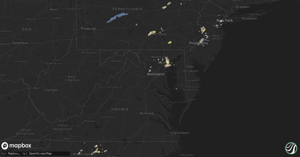
Hail Map in Maryland on July 17, 2021
Get this storm
July 17 map
$229
one time, instant access
Download today. No call, no setup
Keep the $229
Bought the map and want the full workflow? Apply the entire $229 to a subscription within 7 days. None of it is wasted.
Every map, not just this one
This buys you this map. Subscription and you get every map we run, in the markets you choose from a few cities to whole states to nationwide. Plus real-time alerts the moment a storm fires.
Contact data
Name, contact info, occupancy, even credit band for addresses in the footprint. You go from where it hit to who to call.
Become the source they trust
Unlimited branding weather history reports on demand. You already have the documented answer ready for the property owner, and you are the one who showed up with it.
Property data and RoofTrace estimates
Pull up any address you have got, its value and the exact code rules for that jurisdiction, straight from One Click Code. Then RoofTrace estimates the squares, pitch, and roof value, priced the way you price.
Storm reports in Maryland
Maryland
| Date | Description |
|---|---|
| 07/17/20216:18 PM CDT | Tree down on md-550 near pine tree road. |
| 07/17/20216:11 PM CDT | Tree down on md-26 near crum road. |
| 07/17/20216:10 PM CDT | Tree down on foxville rd west of pryor rd |
| 07/17/20216:10 PM CDT | Large tree down across road in the 15000 block of kelbaugh rd |
| 07/17/20215:01 PM CDT | Several trees down in leitersburg. |
| 07/17/20214:58 PM CDT | Four telephone poles and wires down on leitersburg smithsburg road. |
| 07/17/20214:01 PM CDT | Tree down on stanton friend road. |
| 07/17/20213:28 PM CDT | Large branch down on power lines on gruenther ave between marshall ave and broadwood drive. |
| 07/17/20213:13 PM CDT | Tree and wires down on glen mill road near joiners lane. |
| 07/17/20213:05 PM CDT | Tree down in roadway at the intersection of arundel corp rd and morris hill ave. |
| 07/17/20213:02 PM CDT | Tree down on md-150 |
| 07/17/20213:02 PM CDT | Three trees down on saffa drive. |
| 07/17/20212:46 PM CDT | Tree down on mobile home on beachwood ave near bletzer road. |
| 07/17/20212:46 PM CDT | Two trees down on garden drive and south marylyn avenue. |
| 07/17/20212:45 PM CDT | Tree down on delaware ave. |
| 07/17/20212:43 PM CDT | Tree down on midcounty highway. |
| 07/17/20212:40 PM CDT | Two trees fell onto an apartment building on garden drive causing significant structural damage. |
| 07/17/20212:31 PM CDT | Tree down on bushey road near old washington road. |
| 07/17/20212:30 PM CDT | A local report indicates 1.00 inch wind near 2 ESE ROSEDALE |
| 07/17/20211:53 PM CDT | Trees down in parkville. |
| 07/17/20211:46 PM CDT | Multiple trees down in and around long green. |
| 07/17/20211:25 PM CDT | Tree down on md-25 at seminary avenue. |
| 07/17/20211:25 PM CDT | Multiple trees down in cockeysville. |
| 07/17/20211:24 PM CDT | Tree down on a vehicle near clearfield court and tally ho road. |
| 07/17/20211:16 PM CDT | Tree and power lines down on vehicle. |
| 07/17/20211:10 PM CDT | Tree down on oakland mills road near liberty road. |
| 07/17/202112:42 PM CDT | Multiple trees down near the liberty reservoir. |
| 07/17/20213:57 AM CDT | At 856 PM EDT, a severe thunderstorm was located over Cochranville, or 15 miles west of West Chester, moving northeast at 30 mph. HAZARD...60 mph wind gusts and quarter size hail. SOURCE...Radar indicated. IMPACT...Minor damage to vehicles is possible. Wind damage to roofs, siding, trees, and power lines is possible. Locations impacted include... West Chester, Phoenixville, Coatesville, Westtown, Downingtown, Kennett Square, Royersford, Parkesburg, West Grove, Honey Brook, Cochranville, Pughtown, Marshallton, Lionville-Marchwood, Valley Forge, Glenmoore, Paoli, Chester Springs, Lionville and Ladenberg.This includes Pennsylvania Turnpike between mile markers 304 and 324. |
| 07/17/20212:55 AM CDT | At 754 PM EDT, severe thunderstorms were located along a line extending from near Manchester to Hampstead to Gamber, moving east at 40 mph. HAZARD...60 mph wind gusts. SOURCE...Radar indicated. IMPACT...Damaging winds will cause some trees and large branches to fall. This could injure those outdoors, as well as damage homes and vehicles. Roadways may become blocked by downed trees. Localized power outages are possible. Unsecured light objects may become projectiles. Locations impacted include... Cockeysville, Bel Air South, Bel Air North, Reisterstown, Mays Chapel, Timonium, Fallston, Hampstead, Manchester, Kingsville, Pleasant Hills, Jarrettsville, Gamber, Lutherville-Timonium, Edgewood, Joppatowne, Pylesville, Glen Arm, Upperco and Cardiff. |
| 07/17/20212:34 AM CDT | At 734 PM EDT, severe thunderstorms were located along a line extending from near Gettysburg to 6 miles south of Taneytown, moving northeast at 45 mph. HAZARD...60 mph wind gusts. SOURCE...Radar indicated. IMPACT...Expect damage to roofs, siding, and trees. Locations impacted include... York, Hanover, Weigelstown, Gettysburg, Parkville, Red Lion, Spry, Dallastown, Hampton, Shiloh, East York, Stonybrook-Wilshire, West York, Littlestown, Shrewsbury, Codorus, Grantley, Tyler Run-Queens Gate, McSherrystown and Manchester.This includes Interstate 83 from mile markers 0 to 26. |
| 07/17/20211:44 AM CDT | At 644 PM EDT, a severe thunderstorm was located near Hampton, moving northeast at 35 mph. HAZARD...60 mph wind gusts and penny size hail. SOURCE...Radar indicated. IMPACT...Expect damage to roofs, siding, and trees. Locations impacted include... Harrisburg, York, Lebanon, Lower Allen, Hanover, Hershey, Colonial Park, Weigelstown, Elizabethtown, Columbia, Progress, Middletown, Gettysburg, Mount Joy, Palmyra, New Cumberland, Parkville, Red Lion, Linglestown and Steelton.This includes the following Interstates... The Pennsylvania Turnpike from mile markers 239 to 271. Interstate 78 from mile markers 0 to 8. Interstate 81 from mile markers 67 to 96. Interstate 83 between mile markers 5 and 39...and from mile markers43 to 50. Interstate 283 from mile markers 0 to 2. |
| 07/17/20211:16 AM CDT | At 616 PM EDT, severe thunderstorms were located along a line extending from near Martinsburg to Inwood, moving northeast at 35 mph. HAZARD...60 mph wind gusts. SOURCE...Radar indicated. IMPACT...Damaging winds will cause some trees and large branches to fall. This could injure those outdoors, as well as damage homes and vehicles. Roadways may become blocked by downed trees. Localized power outages are possible. Unsecured light objects may become projectiles. Locations impacted include... Martinsburg, Shepherdstown, Kearneysville, Winebrenners Cross, Shanghai, Arden, Gerrardstown, Vanville and Martinsburg Airport. |
| 07/17/20211:09 AM CDT | At 609 PM EDT, a severe thunderstorm was located near Mount Holly Springs, moving northeast at 35 mph. HAZARD...60 mph wind gusts and quarter size hail. SOURCE...Radar indicated. IMPACT...Hail damage to vehicles is expected. Expect wind damage to roofs, siding, and trees. Locations impacted include... Harrisburg, Carlisle, Lower Allen, Hanover, Hershey, Colonial Park, Weigelstown, Waynesboro, Progress, Mechanicsburg, Middletown, Camp Hill, Gettysburg, Palmyra, New Cumberland, Parkville, Linglestown, Enola, Steelton and Lemoyne.This includes the following Interstates... The Pennsylvania Turnpike from mile markers 220 to 256. Interstate 81 from mile markers 26 to 81. Interstate 83 from mile markers 28 to 50. Interstate 283 from mile markers 0 to 2. |
| 07/17/202112:20 AM CDT | At 520 PM EDT, a severe thunderstorm was located over Fort Ashby, or 9 miles southeast of Bel Air, moving northeast at 40 mph. HAZARD...60 mph wind gusts and quarter size hail. SOURCE...Radar indicated. IMPACT...Damaging winds will cause some trees and large branches to fall. This could injure those outdoors, as well as damage homes and vehicles. Roadways may become blocked by downed trees. Localized power outages are possible. Unsecured light objects may become projectiles. Locations impacted include... Paw Paw, Fort Ashby, Springfield, Green Spring, Oldtown, Spring Gap, Little Orleans, Lineburg, Wagoner, Pumpkin Center, Forest Park, Bellegrove and Green Ridge. |
| 07/16/202111:28 PM CDT | At 428 PM EDT, severe thunderstorms were located along a line extending from Bowleys Quarters to near Sparrows Point, moving northeast at 15 mph. HAZARD...60 mph wind gusts and quarter size hail. SOURCE...Radar indicated. IMPACT...Damaging winds will cause some trees and large branches to fall. This could injure those outdoors, as well as damage homes and vehicles. Roadways may become blocked by downed trees. Localized power outages are possible. Unsecured light objects may become projectiles. Locations impacted include... Baltimore, Middle River, Riviera Beach, Fort Smallwood State Park, Pinehurst, North Point State Park, Sparrows Point, Gibson Island, Bodkin Point, Back River, Millers Island, Glen Burnie, Dundalk, Essex, Pasadena, Lake Shore, Bowleys Quarters, Green Haven, Edgemere and Fort Howard. |
| 07/16/202110:59 PM CDT | At 359 PM EDT, a severe thunderstorm was located over Ferndale, or over Baltimore-Washington Airport, moving northeast at 15 mph. HAZARD...60 mph wind gusts and quarter size hail. SOURCE...Radar indicated. IMPACT...Damaging winds will cause some trees and large branches to fall. This could injure those outdoors, as well as damage homes and vehicles. Roadways may become blocked by downed trees. Localized power outages are possible. Unsecured light objects may become projectiles. Locations impacted include... Baltimore, Severn, Elkridge, Riviera Beach, Baltimore-Washington Airport, Glen Burnie, Pasadena, Ferndale, Brooklyn Park, South Gate, Pumphrey, Linthicum, Lansdowne, Gambrills, Hanover, Harmans and Linthicum Heights. |
| 07/16/202110:50 PM CDT | At 349 PM EDT, a severe thunderstorm was located over Montgomery Village, or near Germantown, moving northeast at 30 mph. HAZARD...60 mph wind gusts and quarter size hail. SOURCE...Radar indicated. IMPACT...Damaging winds will cause some trees and large branches to fall. This could injure those outdoors, as well as damage homes and vehicles. Roadways may become blocked by downed trees. Localized power outages are possible. Unsecured light objects may become projectiles. Locations impacted include... Germantown, Rockville, Gaithersburg, Olney, Damascus, Ellicott City, Randallstown, Montgomery Village, Owings Mills, Eldersburg, Reisterstown, Redland, Mount Airy, Sykesville, Oakland, Gamber, Clarksburg, Derwood, New Windsor and Washington Grove. |
| 07/16/202110:27 PM CDT | At 327 PM EDT, a severe thunderstorm was located over Rosedale, or near Back River, moving southeast at 10 mph. HAZARD...60 mph wind gusts and quarter size hail. SOURCE...Radar indicated. IMPACT...Damaging winds will cause some trees and large branches to fall. This could injure those outdoors, as well as damage homes and vehicles. Roadways may become blocked by downed trees. Localized power outages are possible. Unsecured light objects may become projectiles. Locations impacted include... Baltimore, Middle River, North Point State Park, Sparrows Point, Back River, Millers Island, Dundalk, Essex, Rosedale, Rossville, White Marsh, Bowleys Quarters, Edgemere, Nottingham, Fort Howard, Chase, Eastpoint, Martin State Airport and Turners Station. |
| 07/16/202110:24 PM CDT | At 323 PM EDT, a severe thunderstorm was located near Mount Airy, or 11 miles south of Westminster, moving northeast at 30 mph. HAZARD...60 mph wind gusts and quarter size hail. SOURCE...Radar indicated. IMPACT...Damaging winds will cause some trees and large branches to fall. This could injure those outdoors, as well as damage homes and vehicles. Roadways may become blocked by downed trees. Localized power outages are possible. Unsecured light objects may become projectiles. Locations impacted include... Westminster, Eldersburg, Mount Airy, Hampstead, Sykesville, Gamber, New Windsor, Finksburg, Carrollton, Upperco, Winfield, Louisville, Boring, Watersville, Patapsco, Reese, Uniontown, Woodbine, Wagners Mill and Marston. |
| 07/16/20219:59 PM CDT | At 259 PM EDT, a severe thunderstorm was located over Rosedale, or near Baltimore, moving east at 10 mph. HAZARD...60 mph wind gusts and quarter size hail. SOURCE...Radar indicated. IMPACT...Damaging winds will cause some trees and large branches to fall. This could injure those outdoors, as well as damage homes and vehicles. Roadways may become blocked by downed trees. Localized power outages are possible. Unsecured light objects may become projectiles. Locations impacted include... Baltimore, Middle River, Dundalk, Essex, Rosedale, Rossville, White Marsh, Bowleys Quarters, Edgewood, Joppatowne, Nottingham, Fullerton, Magnolia, Chase, Eastpoint and Martin State Airport. |
| 07/16/20219:56 PM CDT | At 255 PM EDT, a severe thunderstorm was located near Sunnyburn, moving north at 20 mph. HAZARD...60 mph wind gusts and quarter size hail. SOURCE...Radar indicated. IMPACT...Hail damage to vehicles is expected. Expect wind damage to roofs, siding, and trees. Locations impacted include... Quarryville, Delta, Smithville, Shenks Ferry, Holtwood, Sunnyburn, Safe Harbor, Susquehanna Trails, Fawn Grove, Buck, Peach Bottom, Rawlinsville and Airville. |
| 07/16/20219:40 PM CDT | At 239 PM EDT, severe thunderstorms were located along a line extending from near Jarrettsville to Carney, moving east at 15 mph. HAZARD...60 mph wind gusts and quarter size hail. SOURCE...Radar indicated. IMPACT...Damaging winds will cause some trees and large branches to fall. This could injure those outdoors, as well as damage homes and vehicles. Roadways may become blocked by downed trees. Localized power outages are possible. Unsecured light objects may become projectiles. Locations impacted include... Baltimore, Towson, Bel Air South, Parkville, Bel Air North, Carney, Perry Hall, White Marsh, Fallston, Riverside, Hampton, Kingsville, Pleasant Hills, Jarrettsville, Perryman, Edgewood, Joppatowne, Pylesville, Darlington and Glen Arm. |
| 07/16/20218:29 PM CDT | At 129 PM EDT, a severe thunderstorm was located over Oakland, or 10 miles northwest of Historic Ellicott City, moving northeast at 15 mph. HAZARD...60 mph wind gusts and quarter size hail. SOURCE...Radar indicated. IMPACT...Damaging winds will cause some trees and large branches to fall. This could injure those outdoors, as well as damage homes and vehicles. Roadways may become blocked by downed trees. Localized power outages are possible. Unsecured light objects may become projectiles. Locations impacted include... Pikesville, Towson, Randallstown, Owings Mills, Eldersburg, Reisterstown, Lochearn, Mays Chapel, Oakland, Garrison, Ruxton, Louisville, Riderwood, Glyndon, Brooklandville, Mcdonogh, Carrolltowne, Stevenson and Butler. |
| 07/16/20217:10 PM CDT | Couple of trees and wires down leading to road being blocked near intersection of md state highway 650 & brighton dam road. |
| 07/16/20217:08 PM CDT | A local report indicates 58 MPH wind near 6 SSE FISHING CREEK |
All States Impacted by Hail Map on July 17, 2021
Cities Impacted by Hail Map on July 17, 2021
- Lincoln, RI
- Harrisburg, PA
- Dalhart, TX
- Westhope, ND
- Souris, ND
- Atwood, CO
- Merino, CO
- Sterling, CO
- Boone, CO
- Fowler, CO
- Goodwell, OK
- Edgemont, SD
- Stone Ridge, NY
- Hurley, NY
- West Hurley, NY
- Kingston, NY
- Johnstown, NE
- Newtown, PA
- Langhorne, PA
- Lambertville, NJ
- Philadelphia, PA
- Muncy, PA
- Turbotville, PA
- Newark, NJ
- Elizabeth, NJ
- Potomac, MD
- Reston, VA
- Great Falls, VA
- Herndon, VA
- Leesville, SC
- Clarendon, TX
- Claude, TX
- Airville, PA
- Brogue, PA
- Rhinebeck, NY
- Red Hook, NY
- Cheney, KS
- Bloomsburg, PA
- Millville, PA
- Danville, PA
- South Haven, KS
- Geuda Springs, KS
- Rural Hall, NC
- Oxford, NY
- New Paltz, NY
- Clovis, NM
- Las Animas, CO
- Isabella, OK
- Fairview, OK
- Arnett, OK
- Whitney Point, NY
- Saint Petersburg, FL
- Seminole, FL
- Pinellas Park, FL
- Stratford, TX
- Panhandle, TX
- Deer Trail, CO
- Stilwell, OK
- Berlin, MA
- West Boylston, MA
- Boylston, MA
- Worcester, MA
- Shrewsbury, MA
- Clinton, MA
- Kingman, KS
- Vega, TX
- Brush, CO
- Canon City, CO
- Melrose, NM
- Hereford, TX
- Wildorado, TX
- Sykesville, MD
- Marriottsville, MD
- Lead, SD
- Amarillo, TX
- Rembert, SC
- Purdum, NE
- Canyon, TX
- Wiggins, CO
- Mount Airy, MD
- Carlisle, PA
- Shermans Dale, PA
- Landisburg, PA
- Newville, PA
- Humansville, MO
- Bolivar, MO
- Dunnegan, MO
- Salt Point, NY
- Hyde Park, NY
- Mebane, NC
- Burlington, NC
- Cedar Grove, NC
- Marysville, PA
- Duncannon, PA
- Jasper, NY
- Woodhull, NY
- Addison, NY
- Greenwood, NY
- Cameron Mills, NY
- Canadian, TX
- Fort Morgan, CO
- Turon, KS
- Miami, TX
- Mobeetie, TX
- Custer, SD
- Orange, VA
- Crook, CO
- Peetz, CO
- Denham Springs, LA
- Portales, NM
- Mayesville, SC
- Gable, SC
- Sumter, SC
- Evening Shade, AR
- Lincoln, AR
- Canehill, AR
- Evansville, AR
- Cunningham, KS
- Brule, NE
- Burlington, NJ
- Louisa, VA
- Gordonsville, VA
- Saint Pauls, NC
- Blackstone, VA
- McKenney, VA
- Reidsville, NC
- Muncy Valley, PA
- Benton, PA
- Unityville, PA
- Auburn, MA
- Newark Valley, NY
- Cincinnatus, NY
- Dryden, NY
- Greene, NY
- Slaterville Springs, NY
- Binghamton, NY
- Berkshire, NY
- Lisle, NY
- Richford, NY
- Ithaca, NY
- Newfield, NY
- Marathon, NY
- Willet, NY
- Maine, NY
- Willseyville, NY
- Glen Aubrey, NY
- Smithville Flats, NY
- Harford, NY
- Spencer, NY
- McDonough, NY
- Brooktondale, NY
- Hendersonville, NC
- Black Mountain, NC
- Washington Boro, PA
- Lancaster, PA
- Conestoga, PA
- Millersville, PA
- Elon, NC
- Browns Summit, NC
- McLeansville, NC
- Greensboro, NC
- Gibsonville, NC
- Ridgeland, SC
- Dundalk, MD
- Rosedale, MD
- Essex, MD
- Baltimore, MD
- Bottineau, ND
- Halifax, PA
- Willington, CT
- Ashford, CT
- Storrs Mansfield, CT
- San Jon, NM
- Calhan, CO
- Parkville, MD
- Lake Lure, NC
- Columbia, VA
- Kents Store, VA
- Baker, MT
- Camp Crook, SD
- Buffalo, SD
- Florissant, CO
- Ford, VA
- Amelia Court House, VA
- Lecompte, LA
- Snyder, CO
- Lisco, NE
- Rockland, ID
- American Falls, ID
- Pampa, TX
- Warrenton, VA
- Broad Run, VA
- Otis, MA
- Rantoul, KS
- Torrington, WY
- Cherry Valley, MA
- Pritchett, CO
- Hugo, CO
- Limon, CO
- New Port Richey, FL
- Sudan, TX
- Fairfield, NJ
- Caldwell, NJ
- Little Falls, NJ
- Cedar Grove, NJ
- Wayne, NJ
- Lexington, NC
- Seymour, TX
- Tulsa, OK
- Antler, ND
- Fairfax, OK
- Charles City, VA
- Henrico, VA
- Providence Forge, VA
- Quinton, VA
- Sandston, VA
- Coward, SC
- North Grafton, MA
- High Falls, NY
- Cottekill, NY
- Summerfield, NC
- Springfield, CO
- Hudson, KS
- Havana, KS
- Niotaze, KS
- Clayton, NM
- Cameron, NY
- Williamsburg, VA
- Lynchburg, VA
- Rustburg, VA
- Columbia, SC
- Lake Katrine, NY
- Saugerties, NY
- Titusville, NJ
- Trenton, NJ
- South Hill, VA
- Kenbridge, VA
- Murdock, KS
- Groom, TX
- Colorado Springs, CO
- Sylvia, KS
- St John, KS
- Stockville, NE
- New Hope, PA
- Stockton, NJ
- Ringoes, NJ
- Winston Salem, NC
- Pfafftown, NC
- Alma, GA
- Danville, VA
- Oldsmar, FL
- Dunning, NE
- Florence, NJ
- Levittown, PA
- Morrisville, PA
- Fairless Hills, PA
- Bristol, PA
- Peyton, CO
- Chenango Forks, NY
- Yanceyville, NC
- Troupsburg, NY
- Quanah, TX
- Happy, TX
- Bois D Arc, MO
- Willard, MO
- Ash Grove, MO
- Springfield, MO
- Rowesville, SC
- Wheeler, TX
- Vernon, TX
- Hillrose, CO
- Okeene, OK
- Benson, NC
- Angier, NC
- Lovington, NM
- Roswell, NM
- Madrid, NE
- Carmel, NY
- Wibaux, MT
- Sherwood, ND
- Plevna, KS
- Abbyville, KS
- Carthage, NC
- Vass, NC
- Mansfield Center, CT
- Newkirk, OK
- Huntingdon, PA
- Hot Springs, SD
- Lumberton, NC
- Baton Rouge, LA
- Prairieville, LA
- Broken Arrow, OK
- Grandfield, OK
- Dayville, CT
- Pomfret Center, CT
- Broadview, NM
- Staten Island, NY
- Baxley, GA
- Furlong, PA
- Frenchtown, NJ
- Flemington, NJ
- Lumberville, PA
- Doylestown, PA
- Carversville, PA
- Conover, NC
- Olar, SC
- Ehrhardt, SC
- Mohall, ND
- Eldorado, OK
- Elizabethport, NJ
- Pierce City, MO
- Granby, MO
- Lewisville, NC
- Harrison, NE
- Stafford Springs, CT
- Roxbury, CT
- Southbury, CT
- Palmyra, NJ
- Merchantville, NJ
- Camden, NJ
- Riverton, NJ
- Bensalem, PA
- Pennsauken, NJ
- Riverside, NJ
- Beverly, NJ
- Kirk, CO
- New Britain, CT
- Newington, CT
- Bristol, CT
- Southington, CT
- Plainville, CT
- West Hartford, CT
- Farmington, CT
- Grant, NE
- Glen Burnie, MD
- Curtis Bay, MD
- Sparrows Point, MD
- Fleming, CO
- Jeffersonton, VA
- Remington, VA
- Ruffin, NC
- Pelham, NC
- Gallion, AL
- Faunsdale, AL
- Piscataway, NJ
- Pollock, LA
- Woodstock, NY
- Byers, CO
- Dunseith, ND
- Swansea, SC
- Chestertown, MD
- Towson, MD
- Nottingham, MD
- North Scituate, RI
- Chepachet, RI
- Foster, RI
- East Killingly, CT
- Ellicott City, MD
- Windsor Mill, MD
- Alexandria, LA
- Fort Howard, MD
- Castle Creek, NY
- Middle River, MD
- Glen Arm, MD
- Brooklyn, MD
- Cockeysville, MD
- Millersville, MD
- Perry Hall, MD
- Pasadena, MD
- Phoenix, MD
- Lutherville Timonium, MD
- Tivoli, NY
- Washington Depot, CT
- New Milford, CT
- Port Ewen, NY
- Stevensville, PA
- Wyalusing, PA
- Laceyville, PA
- Maxwell, NE
- Bennett, CO
- Scranton, SC
- Timmonsville, SC
- Dry Prong, LA
- Colfax, LA
- Bentley, LA
- Candor, NY
- Cape Fair, MO
- Bamberg, SC
- Garden Plain, KS
- Milton, KS
- Viola, KS
- Metuchen, NJ
- Fords, NJ
- Iselin, NJ
- South Plainfield, NJ
- Edison, NJ
- Alden, KS
- Wedgefield, SC
- Paducah, TX
- Front Royal, VA
- White Post, VA
- Boyce, VA
- Manning, SC
- Hartley, TX
- Hardeeville, SC
- Okarche, OK
- Whitehall, PA
- Allentown, PA
- Clearwater, FL
- Dunedin, FL
- Orangeburg, SC
- Wagon Mound, NM
- Sutton, MA
- Oxford, MA
- Millbury, MA
- Church Creek, MD
- Cambridge, MD
- Dover, DE
- Neosho, MO
- Jeffersonville, NY
- Fort Cobb, OK
- Arlington, KS
- Lyons, GA
- Hartsville, SC
- Lance Creek, WY
- Rochdale, MA
- Northborough, MA
- Leicester, MA
- Kingston, PA
- Luzerne, PA
- Wilkes Barre, PA
- Plymouth, PA
- Booker, TX
- Red Lion, PA
- Wrightsville, PA
- Windsor, PA
- Gadsden, SC
- Staatsburg, NY
- Bristol, FL
- Voorhees, NJ
- Marlton, NJ
- Cherry Hill, NJ
- Mcalister, NM
- Palmyra, VA
- Pretty Prairie, KS
- Ruckersville, VA
- Earlysville, VA
- Charlottesville, VA
- Dyke, VA
- Owings Mills, MD
- Stevenson, MD
- Pikesville, MD
- Germantown, MD
- Gaithersburg, MD
- Bolton, MA
- Harvard, MA
- Devens, MA
- Lancaster, MA
- Friona, TX
- Bowman, SC
- Catskill, NY
- Lane, KS
- Osawatomie, KS
- Brunson, SC
- Melbourne, AR
- Endicott, NY
- Haven, KS
- Keasbey, NJ
- Sayreville, NJ
- South Amboy, NJ
- Danbury, NC
- Lawsonville, NC
- Bennettsville, SC
- Wallace, SC
- Highland, NY
- Ulster Park, NY
- Cameron, NC
- Gaston, SC
- West Columbia, SC
- Shell Knob, MO
- Lampe, MO
- Hale Center, TX
- Plainview, TX
- Olanta, PA
- Clearfield, PA
- Curwensville, PA
- Clymer, PA
- Dixonville, PA
- New Millport, PA
- Osceola Mills, PA
- Houtzdale, PA
- Glen Campbell, PA
- Philipsburg, PA
- Hillsdale, PA
- Arcadia, PA
- Mahaffey, PA
- Marion Center, PA
- Commodore, PA
- Cherry Tree, PA
- Gipsy, PA
- Indiana, PA
- West Decatur, PA
- Glen Richey, PA
- Irvona, PA
- La Jose, PA
- Ernest, PA
- Rochester Mills, PA
- Little Meadows, PA
- Friendsville, PA
- Summerfield, TX
- Willingboro, NJ
- Columbus, NJ
- Bordentown, NJ
- Jobstown, NJ
- Mount Holly, NJ
- Fallon, MT
- Freeville, NY


