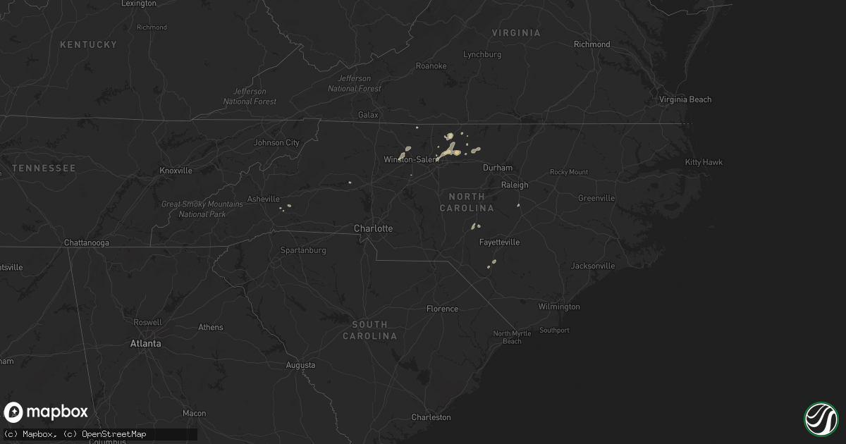
Hail Map in North Carolina on July 17, 2021
Get this storm
July 17 map
$229
one time, instant access
Download today. No call, no setup
Keep the $229
Bought the map and want the full workflow? Apply the entire $229 to a subscription within 7 days. None of it is wasted.
Every map, not just this one
This buys you this map. Subscription and you get every map we run, in the markets you choose from a few cities to whole states to nationwide. Plus real-time alerts the moment a storm fires.
Contact data
Name, contact info, occupancy, even credit band for addresses in the footprint. You go from where it hit to who to call.
Become the source they trust
Unlimited branding weather history reports on demand. You already have the documented answer ready for the property owner, and you are the one who showed up with it.
Property data and RoofTrace estimates
Pull up any address you have got, its value and the exact code rules for that jurisdiction, straight from One Click Code. Then RoofTrace estimates the squares, pitch, and roof value, priced the way you price.
Storm reports in North Carolina
North Carolina
| Date | Description |
|---|---|
| 07/17/20215:11 PM CDT | A tree fell on power lines on surl mount tirzah rd. Time estimated by radar. |
| 07/17/20215:04 PM CDT | A tree was reported down near the intersection of dick holeman rd and forest view dr. Time estimated by radar. |
| 07/17/20215:02 PM CDT | Power lines were reported down across the roadway near the intersection of terry rd and st. Marys rd. Time estimated by radar. |
| 07/17/20215:02 PM CDT | A tree was reported down near the intersection of ned moore rd and windy creek rd. Time estimated by radar. |
| 07/17/20215:00 PM CDT | A tree was reported down near the intersection of nc highway 57 and guess rd. Time estimated by radar. |
| 07/17/20214:58 PM CDT | A tree was reported down near the intersection of burlington rd and snipes rd. Time estimated by radar. |
| 07/17/20214:55 PM CDT | A tree was reported down near the intersection of n hassel st. And w tryon st. Time estimated by radar. |
| 07/17/20214:35 PM CDT | A tree was reported down near the intersection of bason rd and pine lake ln. |
| 07/17/20214:20 PM CDT | Additional trees reported down in the williamsburg area. |
| 07/17/20214:04 PM CDT | A tree was reported down near the intersection of w friendly ave and hobbs rd. |
| 07/17/20213:58 PM CDT | A tree was reported down near the intersection of east cone blvd and yanceyville st. |
| 07/17/20213:58 PM CDT | A tree was reported down near the intersection of rankin rd and summit ave. |
| 07/17/20213:55 PM CDT | A tree fell down and knocked down power lines near the intersection of rosecrest dr. And hawthorne st in greensboro. |
| 07/17/20213:30 PM CDT | Two large tree limbs down. |
| 07/17/20213:05 PM CDT | A couple trees down. |
| 07/17/20212:05 PM CDT | Several trees down near highway 87. |
| 07/17/202112:58 PM CDT | Trees down near i-74. |
| 07/17/202112:40 PM CDT | At least 4 trees were either blown over or heavily damaged in riverbend park. Other large limbs down in the park. |
| 07/17/20214:59 AM CDT | At 958 PM EDT, a severe thunderstorm was located over Leasburg, or 9 miles west of Roxboro, moving east at 35 mph. HAZARD...60 mph wind gusts. SOURCE...Radar indicated. IMPACT...Expect damage to roofs, siding, and trees. Locations impacted include... Oxford, Roxboro, Concord, Stovall, Bethel Hill, Bushy Fork, Hyco Lake, Mayo Reservoir, Hyco Marina and Berea. |
| 07/17/20214:18 AM CDT | At 918 PM EDT, severe thunderstorms were located along a line extending from Eden to near Monroeton, moving east at 40 mph. HAZARD...60 mph wind gusts. SOURCE...Radar indicated. IMPACT...Expect damage to roofs, siding, and trees. Locations impacted include... Eden... Reidsville... Wentworth... Yanceyville... Bethel... Jericho... and Prospect Hill. |
| 07/17/20213:49 AM CDT | At 848 PM EDT, severe thunderstorms were located along a line extending from near Pine Hall to near Kernersville, moving east at 35 mph. HAZARD...60 mph wind gusts and nickel size hail. SOURCE...Radar indicated. At 835 pm, law enforcement reported a tree down on Olivette Chruch Rd. IMPACT...Expect damage to roofs, siding, and trees. Locations impacted include... Greensboro, Winston-Salem, High Point, Kernersville, Summerfield, Stokesdale, Walkertown, Haw River State Park, Lake Jeanette Marina and Monticello. |
| 07/17/20213:14 AM CDT | At 814 PM EDT, severe thunderstorms were located along a line extending from near Fieldale to near Ayersville, moving east at 30 mph. HAZARD...60 mph wind gusts. SOURCE...Radar indicated. IMPACT...Expect damage to roofs, siding, and trees. Locations impacted include... Eden... Martinsville... Stoneville... Spencer... Callands... Axton... and Leatherwood.This includes The following Locations The Martinsville Speedway andMartinsville Airport. |
| 07/17/20213:10 AM CDT | At 809 PM EDT, a severe thunderstorm was located near Enon, or 7 miles west of Winston-Salem, moving east at 25 mph. HAZARD...60 mph wind gusts and nickel size hail. SOURCE...Radar indicated. IMPACT...Expect damage to roofs, siding, and trees. Locations impacted include... Winston-Salem, Thomasville, Kernersville, Clemmons, Bermuda Run, Lewisville, Walkertown, Rural Hall, Pfafftown and Belews Creek. |
| 07/17/20212:44 AM CDT | At 744 PM EDT, severe thunderstorms were located along a line extending from near Mabry Mill to near Swancreek, moving east at 25 mph. HAZARD...60 mph wind gusts. SOURCE...Radar indicated. IMPACT...Expect damage to roofs, siding, and trees. Locations impacted include... Mount Airy... Elkin... Fairview... Flat Rock... Yadkinville... Jonesville... and Dobson. |
| 07/17/202112:44 AM CDT | At 544 PM EDT, severe thunderstorms were located along a line extending from near Prospect Hill to near Mebane, moving east at 40 mph. HAZARD...60 mph wind gusts and quarter size hail. SOURCE...Radar indicated. IMPACT...Hail damage to vehicles is expected. Expect wind damage to roofs, siding, and trees. Locations impacted include... Durham, Roxboro, Hillsborough, Rougemont, Bushy Fork, Lake Michie, Moriah, Eno River State Park, Surl and Bahama. |
| 07/17/202112:21 AM CDT | At 520 PM EDT, a severe thunderstorm was located near Camp Springs, moving east at 35 mph. HAZARD...60 mph wind gusts and penny size hail. SOURCE...Radar indicated. IMPACT...Expect damage to roofs, siding, and trees. Locations impacted include... Burlington, Graham, Hillsborough, Mebane, Elon, Gibsonville, Haw River, Swepsonville, Alamance and Carr. |
| 07/17/202112:01 AM CDT | At 501 PM EDT, a severe thunderstorm was located 5 miles northwest of Downtown Asheville, or near Woodfin, moving east at 10 mph. HAZARD...60 mph wind gusts and quarter size hail. SOURCE...Radar indicated. IMPACT...Minor hail damage to vehicles is expected. Expect wind damage to trees and power lines. Locations impacted include... Downtown Asheville, East Asheville, West Asheville, North Asheville, Woodfin, Swannanoa, Weaverville, Leicester, B.R. Parkway-East Asheville To Craggy Gardens and UNC-Asheville. |
| 07/17/202112:00 AM CDT | At 459 PM EDT, severe thunderstorms were located along a line extending from near Camp Springs to near Greensboro, moving east at 20 mph. HAZARD...60 mph wind gusts and quarter size hail. SOURCE...Radar indicated. IMPACT...Hail damage to vehicles is expected. Expect wind damage to roofs, siding, and trees. Locations impacted include... Reidsville... Yanceyville... Jericho... Prospect Hill... Camp Springs... Leasburg... and Topnot. |
| 07/16/202111:43 PM CDT | At 442 PM EDT, a severe thunderstorm was located near High Point, moving northeast at 30 mph. HAZARD...60 mph wind gusts and penny size hail. SOURCE...Radar indicated. IMPACT...Expect damage to roofs, siding, and trees. Locations impacted include... Greensboro, High Point, McLeansville, Summerfield, Gibsonville, Pleasant Garden, Jamestown, Haw River State Park, Lake Guilford Mackintosh Marina and Forest Oaks. |
| 07/16/202111:24 PM CDT | At 423 PM EDT, a severe thunderstorm was located 11 miles northwest of Morganton, or near Table Rock, moving east at 20 mph. HAZARD...60 mph wind gusts and quarter size hail. SOURCE...Radar indicated. IMPACT...Minor hail damage to vehicles is expected. Expect wind damage to trees and power lines. Locations impacted include... Lenoir, Gamewell, Cajah's Mountain, Cedar Rock, Table Rock, Edgemont, Globe, Collettsville, Patterson and Upton. |
| 07/16/202111:00 PM CDT | At 400 PM EDT, a severe thunderstorm was located over Harrisons Crossroads, or near Reidsville, moving east at 15 mph. HAZARD...60 mph wind gusts and quarter size hail. SOURCE...Radar indicated. IMPACT...Hail damage to vehicles is expected. Expect wind damage to roofs, siding, and trees. Locations impacted include... Reidsville... Wentworth... Yanceyville... Bethel... Providence... Camp Springs... and Jericho. |
| 07/16/202110:48 PM CDT | At 348 PM EDT, a severe thunderstorm was located over Mayfield, moving northeast at 15 mph. HAZARD...60 mph wind gusts. SOURCE...Radar indicated. IMPACT...Expect damage to roofs, siding, and trees. Locations impacted include... Danville... Bethel... Providence... Mayfield... Blairs... Milton... and Dry Fork.This includes The following Location Danville Airport. |
| 07/16/20219:56 PM CDT | At 256 PM EDT, a severe thunderstorm was located near Reidsville, moving northeast at 15 mph. HAZARD...60 mph wind gusts. SOURCE...Radar indicated. IMPACT...Expect damage to roofs, siding, and trees. Locations impacted include... Reidsville... Yanceyville... Bethel... Providence... Camp Springs... Quick... and Blanch. |
| 07/16/20219:23 PM CDT | At 220 PM EDT, a severe thunderstorm was located over Chavistown, or near Bennettsville, moving northeast at 10 mph. HAZARD...60 mph wind gusts and penny size hail. SOURCE...Radar indicated. IMPACT...Expect wind damage to trees and power lines. Locations impacted include... Bennettsville, Mccoll, Chavistown and Wallace. |
| 07/16/20219:13 PM CDT | Roxboro fire department reports trees fell on power lines and a car outside the city of hurdle mills. The intersection was near clay long rd and hurdle mills rd. Time e |
| 07/16/20219:13 PM CDT | Law enforcement confirms multiple trees reported down near the intersection of dick holeman rd and durham rd. |
| 07/16/20218:33 PM CDT | At 133 PM EDT, a severe thunderstorm was located 7 miles south of Taylorsville, or 4 miles northwest of Lookout Shoals Lake, moving northeast at 15 mph. HAZARD...60 mph wind gusts and quarter size hail. SOURCE...Radar indicated. IMPACT...Minor hail damage to vehicles is expected. Expect wind damage to trees and power lines. Locations impacted include... Stony Point, Lookout Shoals Lake, Hiddenite, Millersville, Scotts, Oxford and Lake Hickory. |
| 07/16/20218:22 PM CDT | Multiple trees down in the reidsville area. |
| 07/16/20218:14 PM CDT | Multiple trees down in the stoneville area. |
| 07/16/20217:54 PM CDT | A tree was reported down across highway 68 near the intersection of case ridge dr and nc highway 68. Time estimated by radar. |
| 07/16/20217:54 PM CDT | A tree was reported down near the intersection of nc highway 68 and oak ridge rd. Time estimated by radar. |
| 07/16/20217:52 PM CDT | Report from mping: trees uprooted or snapped; roof blown off. Time estimated by radar. |
| 07/16/20217:40 PM CDT | Tree down in walnut cove. |
| 07/16/20217:35 PM CDT | Multiple trees down near the intersection of tuttle ridge rd and baux mountain rd. Time estimated by radar. |
| 07/16/20217:35 PM CDT | Multiple trees down near the 6000 block of sullivan town rd. Time estimated by radar. |
| 07/16/20217:32 PM CDT | Multiple trees reported down near the 8900 block of red bank rd. Time estimated by radar. |
| 07/16/20217:30 PM CDT | 3 trees down in the garmanton area. |
| 07/16/20217:17 PM CDT | Tree down on pine street in king. |
| 07/16/20217:14 PM CDT | A tree was reported down at the intersection of olivet church rd and birchdale dr. Time estimated by radar. |
All States Impacted by Hail Map on July 17, 2021
Cities Impacted by Hail Map on July 17, 2021
- Lincoln, RI
- Harrisburg, PA
- Dalhart, TX
- Westhope, ND
- Souris, ND
- Atwood, CO
- Merino, CO
- Sterling, CO
- Boone, CO
- Fowler, CO
- Goodwell, OK
- Edgemont, SD
- Stone Ridge, NY
- Hurley, NY
- West Hurley, NY
- Kingston, NY
- Johnstown, NE
- Newtown, PA
- Langhorne, PA
- Lambertville, NJ
- Philadelphia, PA
- Muncy, PA
- Turbotville, PA
- Newark, NJ
- Elizabeth, NJ
- Potomac, MD
- Reston, VA
- Great Falls, VA
- Herndon, VA
- Leesville, SC
- Clarendon, TX
- Claude, TX
- Airville, PA
- Brogue, PA
- Rhinebeck, NY
- Red Hook, NY
- Cheney, KS
- Bloomsburg, PA
- Millville, PA
- Danville, PA
- South Haven, KS
- Geuda Springs, KS
- Rural Hall, NC
- Oxford, NY
- New Paltz, NY
- Clovis, NM
- Las Animas, CO
- Isabella, OK
- Fairview, OK
- Arnett, OK
- Whitney Point, NY
- Saint Petersburg, FL
- Seminole, FL
- Pinellas Park, FL
- Stratford, TX
- Panhandle, TX
- Deer Trail, CO
- Stilwell, OK
- Berlin, MA
- West Boylston, MA
- Boylston, MA
- Worcester, MA
- Shrewsbury, MA
- Clinton, MA
- Kingman, KS
- Vega, TX
- Brush, CO
- Canon City, CO
- Melrose, NM
- Hereford, TX
- Wildorado, TX
- Sykesville, MD
- Marriottsville, MD
- Lead, SD
- Amarillo, TX
- Rembert, SC
- Purdum, NE
- Canyon, TX
- Wiggins, CO
- Mount Airy, MD
- Carlisle, PA
- Shermans Dale, PA
- Landisburg, PA
- Newville, PA
- Humansville, MO
- Bolivar, MO
- Dunnegan, MO
- Salt Point, NY
- Hyde Park, NY
- Mebane, NC
- Burlington, NC
- Cedar Grove, NC
- Marysville, PA
- Duncannon, PA
- Jasper, NY
- Woodhull, NY
- Addison, NY
- Greenwood, NY
- Cameron Mills, NY
- Canadian, TX
- Fort Morgan, CO
- Turon, KS
- Miami, TX
- Mobeetie, TX
- Custer, SD
- Orange, VA
- Crook, CO
- Peetz, CO
- Denham Springs, LA
- Portales, NM
- Mayesville, SC
- Gable, SC
- Sumter, SC
- Evening Shade, AR
- Lincoln, AR
- Canehill, AR
- Evansville, AR
- Cunningham, KS
- Brule, NE
- Burlington, NJ
- Louisa, VA
- Gordonsville, VA
- Saint Pauls, NC
- Blackstone, VA
- McKenney, VA
- Reidsville, NC
- Muncy Valley, PA
- Benton, PA
- Unityville, PA
- Auburn, MA
- Newark Valley, NY
- Cincinnatus, NY
- Dryden, NY
- Greene, NY
- Slaterville Springs, NY
- Binghamton, NY
- Berkshire, NY
- Lisle, NY
- Richford, NY
- Ithaca, NY
- Newfield, NY
- Marathon, NY
- Willet, NY
- Maine, NY
- Willseyville, NY
- Glen Aubrey, NY
- Smithville Flats, NY
- Harford, NY
- Spencer, NY
- McDonough, NY
- Brooktondale, NY
- Hendersonville, NC
- Black Mountain, NC
- Washington Boro, PA
- Lancaster, PA
- Conestoga, PA
- Millersville, PA
- Elon, NC
- Browns Summit, NC
- McLeansville, NC
- Greensboro, NC
- Gibsonville, NC
- Ridgeland, SC
- Dundalk, MD
- Rosedale, MD
- Essex, MD
- Baltimore, MD
- Bottineau, ND
- Halifax, PA
- Willington, CT
- Ashford, CT
- Storrs Mansfield, CT
- San Jon, NM
- Calhan, CO
- Parkville, MD
- Lake Lure, NC
- Columbia, VA
- Kents Store, VA
- Baker, MT
- Camp Crook, SD
- Buffalo, SD
- Florissant, CO
- Ford, VA
- Amelia Court House, VA
- Lecompte, LA
- Snyder, CO
- Lisco, NE
- Rockland, ID
- American Falls, ID
- Pampa, TX
- Warrenton, VA
- Broad Run, VA
- Otis, MA
- Rantoul, KS
- Torrington, WY
- Cherry Valley, MA
- Pritchett, CO
- Hugo, CO
- Limon, CO
- New Port Richey, FL
- Sudan, TX
- Fairfield, NJ
- Caldwell, NJ
- Little Falls, NJ
- Cedar Grove, NJ
- Wayne, NJ
- Lexington, NC
- Seymour, TX
- Tulsa, OK
- Antler, ND
- Fairfax, OK
- Charles City, VA
- Henrico, VA
- Providence Forge, VA
- Quinton, VA
- Sandston, VA
- Coward, SC
- North Grafton, MA
- High Falls, NY
- Cottekill, NY
- Summerfield, NC
- Springfield, CO
- Hudson, KS
- Havana, KS
- Niotaze, KS
- Clayton, NM
- Cameron, NY
- Williamsburg, VA
- Lynchburg, VA
- Rustburg, VA
- Columbia, SC
- Lake Katrine, NY
- Saugerties, NY
- Titusville, NJ
- Trenton, NJ
- South Hill, VA
- Kenbridge, VA
- Murdock, KS
- Groom, TX
- Colorado Springs, CO
- Sylvia, KS
- St John, KS
- Stockville, NE
- New Hope, PA
- Stockton, NJ
- Ringoes, NJ
- Winston Salem, NC
- Pfafftown, NC
- Alma, GA
- Danville, VA
- Oldsmar, FL
- Dunning, NE
- Florence, NJ
- Levittown, PA
- Morrisville, PA
- Fairless Hills, PA
- Bristol, PA
- Peyton, CO
- Chenango Forks, NY
- Yanceyville, NC
- Troupsburg, NY
- Quanah, TX
- Happy, TX
- Bois D Arc, MO
- Willard, MO
- Ash Grove, MO
- Springfield, MO
- Rowesville, SC
- Wheeler, TX
- Vernon, TX
- Hillrose, CO
- Okeene, OK
- Benson, NC
- Angier, NC
- Lovington, NM
- Roswell, NM
- Madrid, NE
- Carmel, NY
- Wibaux, MT
- Sherwood, ND
- Plevna, KS
- Abbyville, KS
- Carthage, NC
- Vass, NC
- Mansfield Center, CT
- Newkirk, OK
- Huntingdon, PA
- Hot Springs, SD
- Lumberton, NC
- Baton Rouge, LA
- Prairieville, LA
- Broken Arrow, OK
- Grandfield, OK
- Dayville, CT
- Pomfret Center, CT
- Broadview, NM
- Staten Island, NY
- Baxley, GA
- Furlong, PA
- Frenchtown, NJ
- Flemington, NJ
- Lumberville, PA
- Doylestown, PA
- Carversville, PA
- Conover, NC
- Olar, SC
- Ehrhardt, SC
- Mohall, ND
- Eldorado, OK
- Elizabethport, NJ
- Pierce City, MO
- Granby, MO
- Lewisville, NC
- Harrison, NE
- Stafford Springs, CT
- Roxbury, CT
- Southbury, CT
- Palmyra, NJ
- Merchantville, NJ
- Camden, NJ
- Riverton, NJ
- Bensalem, PA
- Pennsauken, NJ
- Riverside, NJ
- Beverly, NJ
- Kirk, CO
- New Britain, CT
- Newington, CT
- Bristol, CT
- Southington, CT
- Plainville, CT
- West Hartford, CT
- Farmington, CT
- Grant, NE
- Glen Burnie, MD
- Curtis Bay, MD
- Sparrows Point, MD
- Fleming, CO
- Jeffersonton, VA
- Remington, VA
- Ruffin, NC
- Pelham, NC
- Gallion, AL
- Faunsdale, AL
- Piscataway, NJ
- Pollock, LA
- Woodstock, NY
- Byers, CO
- Dunseith, ND
- Swansea, SC
- Chestertown, MD
- Towson, MD
- Nottingham, MD
- North Scituate, RI
- Chepachet, RI
- Foster, RI
- East Killingly, CT
- Ellicott City, MD
- Windsor Mill, MD
- Alexandria, LA
- Fort Howard, MD
- Castle Creek, NY
- Middle River, MD
- Glen Arm, MD
- Brooklyn, MD
- Cockeysville, MD
- Millersville, MD
- Perry Hall, MD
- Pasadena, MD
- Phoenix, MD
- Lutherville Timonium, MD
- Tivoli, NY
- Washington Depot, CT
- New Milford, CT
- Port Ewen, NY
- Stevensville, PA
- Wyalusing, PA
- Laceyville, PA
- Maxwell, NE
- Bennett, CO
- Scranton, SC
- Timmonsville, SC
- Dry Prong, LA
- Colfax, LA
- Bentley, LA
- Candor, NY
- Cape Fair, MO
- Bamberg, SC
- Garden Plain, KS
- Milton, KS
- Viola, KS
- Metuchen, NJ
- Fords, NJ
- Iselin, NJ
- South Plainfield, NJ
- Edison, NJ
- Alden, KS
- Wedgefield, SC
- Paducah, TX
- Front Royal, VA
- White Post, VA
- Boyce, VA
- Manning, SC
- Hartley, TX
- Hardeeville, SC
- Okarche, OK
- Whitehall, PA
- Allentown, PA
- Clearwater, FL
- Dunedin, FL
- Orangeburg, SC
- Wagon Mound, NM
- Sutton, MA
- Oxford, MA
- Millbury, MA
- Church Creek, MD
- Cambridge, MD
- Dover, DE
- Neosho, MO
- Jeffersonville, NY
- Fort Cobb, OK
- Arlington, KS
- Lyons, GA
- Hartsville, SC
- Lance Creek, WY
- Rochdale, MA
- Northborough, MA
- Leicester, MA
- Kingston, PA
- Luzerne, PA
- Wilkes Barre, PA
- Plymouth, PA
- Booker, TX
- Red Lion, PA
- Wrightsville, PA
- Windsor, PA
- Gadsden, SC
- Staatsburg, NY
- Bristol, FL
- Voorhees, NJ
- Marlton, NJ
- Cherry Hill, NJ
- Mcalister, NM
- Palmyra, VA
- Pretty Prairie, KS
- Ruckersville, VA
- Earlysville, VA
- Charlottesville, VA
- Dyke, VA
- Owings Mills, MD
- Stevenson, MD
- Pikesville, MD
- Germantown, MD
- Gaithersburg, MD
- Bolton, MA
- Harvard, MA
- Devens, MA
- Lancaster, MA
- Friona, TX
- Bowman, SC
- Catskill, NY
- Lane, KS
- Osawatomie, KS
- Brunson, SC
- Melbourne, AR
- Endicott, NY
- Haven, KS
- Keasbey, NJ
- Sayreville, NJ
- South Amboy, NJ
- Danbury, NC
- Lawsonville, NC
- Bennettsville, SC
- Wallace, SC
- Highland, NY
- Ulster Park, NY
- Cameron, NC
- Gaston, SC
- West Columbia, SC
- Shell Knob, MO
- Lampe, MO
- Hale Center, TX
- Plainview, TX
- Olanta, PA
- Clearfield, PA
- Curwensville, PA
- Clymer, PA
- Dixonville, PA
- New Millport, PA
- Osceola Mills, PA
- Houtzdale, PA
- Glen Campbell, PA
- Philipsburg, PA
- Hillsdale, PA
- Arcadia, PA
- Mahaffey, PA
- Marion Center, PA
- Commodore, PA
- Cherry Tree, PA
- Gipsy, PA
- Indiana, PA
- West Decatur, PA
- Glen Richey, PA
- Irvona, PA
- La Jose, PA
- Ernest, PA
- Rochester Mills, PA
- Little Meadows, PA
- Friendsville, PA
- Summerfield, TX
- Willingboro, NJ
- Columbus, NJ
- Bordentown, NJ
- Jobstown, NJ
- Mount Holly, NJ
- Fallon, MT
- Freeville, NY


