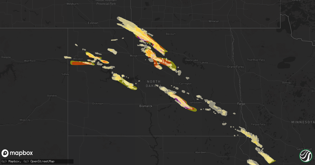
Hail Map in North Dakota on July 14, 2024
Get this storm
July 14 map
$229
one time, instant access
Download today. No call, no setup
Keep the $229
Bought the map and want the full workflow? Apply the entire $229 to a subscription within 7 days. None of it is wasted.
Every map, not just this one
This buys you this map. Subscription and you get every map we run, in the markets you choose from a few cities to whole states to nationwide. Plus real-time alerts the moment a storm fires.
Contact data
Name, contact info, occupancy, even credit band for addresses in the footprint. You go from where it hit to who to call.
Become the source they trust
Unlimited branding weather history reports on demand. You already have the documented answer ready for the property owner, and you are the one who showed up with it.
Property data and RoofTrace estimates
Pull up any address you have got, its value and the exact code rules for that jurisdiction, straight from One Click Code. Then RoofTrace estimates the squares, pitch, and roof value, priced the way you price.
Storm reports in North Dakota
North Dakota
| Date | Description |
|---|---|
| 07/14/20246:40 PM CDT | Late report from the sunday. A few ping pong ball size hail at the beginning... Then smaller hail to follow. Time estimated by radar. |
| 07/14/20245:35 PM CDT | Hail and wind lasted 10 minutes. |
| 07/14/20244:33 AM CDT | Personal weather station rrtclfx in colfax nd reported sustained maximum wind 54 mph with gust to 62 mph. Time acquired from pws website. |
| 07/14/20244:20 AM CDT | Fields of corn damaged. |
| 07/14/20244:00 AM CDT | Large tree branches down. Estimated 60 mph wind gust. |
| 07/14/20243:47 AM CDT | Weatherunderground station. |
| 07/14/20243:22 AM CDT | Report from mping: quarter |
| 07/14/20243:00 AM CDT | Windows throughout two houses were taken out... With siding destroyed. Vehicles dented. Crops in the area were destroyed. Time estimated by radar. |
| 07/14/20242:40 AM CDT | Report relayed via broadcast media with radar estimated time. |
| 07/14/20242:19 AM CDT | Hail ended at 227 am cdt. |
| 07/13/202411:33 PM CDT | A local report indicates 1.00 inch wind near Stanton |
| 07/13/202411:17 PM CDT | Hail ranging from dime to ping pong ball size. Relayed via picture from social media. Hail lasted until 1129 cdt. |
| 07/13/202411:15 PM CDT | Late report from sunday night storms. |
| 07/13/202411:12 PM CDT | Report from mping: quarter |
| 07/13/202411:00 PM CDT | Ping pong ball size hail combined with 80 mph wind gusts to cause extensive crop and house damage in the area. The house at this location lost some windows along with o |
| 07/13/202411:00 PM CDT | Strong thunderstorm winds combined with ping pong ball size hail to cause extensive crop and house damage in the area. The house at this location lost some windows alon |
| 07/13/202410:56 PM CDT | Nearby personal weather station kndesmon3 less than half a mile away from lsr location measured maximum sustained wind of 53 mph with gust to 72 mph at 2254 ct. Time ac |
| 07/13/202410:54 PM CDT | Report from sunday night storms. |
| 07/13/202410:50 PM CDT | Late report from sunday night storms. |
| 07/13/202410:50 PM CDT | Late report from sunday night storms. Time estimated by radar. |
| 07/13/202410:35 PM CDT | Observed gust from nddot us-52 - drake mesonet station. |
| 07/13/202410:35 PM CDT | Late report from the sunday night storms. Lots of small hail with some quarters. Time estimated from radar. |
| 07/13/202410:25 PM CDT | A local report indicates 1.75 inch wind near 1 SSE White Shield |
| 07/13/202410:25 PM CDT | Late report from sunday night. Strong winds accompanied golf ball size hail. |
| 07/13/202410:15 PM CDT | A local report indicates 1.00 inch wind near 1 NE Orrin |
| 07/13/202410:15 PM CDT | Also contained pea size hail which left some drifts. |
| 07/13/202410:15 PM CDT | Hail lasted for about 15 minutes from 10:15pm to 10:30pm. Late report. Callback. |
| 07/13/202410:09 PM CDT | Relayed through broadcast media. Second round of hail. |
| 07/13/202410:05 PM CDT | Social media report of pea size hail from 1000 to 1005 cdt golf ball size hail form 1005 to 1010 cdt. |
| 07/13/20249:55 PM CDT | Late report from sunday night storm. |
| 07/13/20249:55 PM CDT | Late report from sunday night storm. |
| 07/13/20249:27 PM CDT | Reported at denbigh experimental forest. |
| 07/13/20249:20 PM CDT | Photos relayed through broadcast media. Hail lasted for approximately 10 minutes. |
| 07/13/20249:16 PM CDT | Corrects previous hail report from 7 nne towner. Public report of baseball size hail with lots of tennis ball and golf ball size hail. |
| 07/13/20249:10 PM CDT | Trained spotter reported half dollar size hail in newburg. |
| 07/13/20249:00 PM CDT | 2 inch hail in newburg reported by the broadcast media. |
| 07/13/20248:52 PM CDT | Hail from 8:52pm until 9:05pm. 0.60 inch of rain. |
| 07/13/20248:20 PM CDT | Photos from social media showing 1.25 hail 4 miles west of willow city. |
| 07/13/20247:49 PM CDT | Windy too but unable to estimate the speed. |
| 07/13/20247:11 PM CDT | Images of golf ball sized hail damaging a car windshield... Siding... And a window to a house. |
| 07/13/20247:07 PM CDT | Bottineau county sheriff reports the hail is ongoing at the time of call. |
All States Impacted by Hail Map on July 14, 2024
Cities Impacted by Hail Map on July 14, 2024
- Ashton, IL
- Oregon, IL
- Chana, IL
- Rochelle, IL
- Mchenry, IL
- Grant Park, IL
- Kempton, PA
- Shoemakersville, PA
- Hamburg, PA
- New Tripoli, PA
- Fleetwood, PA
- Attica, IN
- Lafayette, IN
- Delphi, IN
- Dayton, IN
- Blandon, PA
- Bringhurst, IN
- Frankfort, IN
- Mulberry, IN
- Kutztown, PA
- Markle, IN
- Rossville, IN
- Kirklin, IN
- Green Lane, PA
- Harleysville, PA
- Perkiomenville, PA
- Huntington, IN
- Michigantown, IN
- Telford, PA
- Schwenksville, PA
- Sheridan, IN
- Bernville, PA
- Arcadia, IN
- Atlanta, IN
- Cloverdale, IN
- Monroeville, IN
- Cicero, IN
- Westfield, IN
- Sellersville, PA
- Zieglerville, PA
- Indianapolis, IN
- Zionsville, IN
- Carmel, IN
- Souderton, PA
- Quakertown, PA
- Elverson, PA
- Glenmoore, PA
- Hatfield, PA
- Lansdale, PA
- Ottawa, OH
- Continental, OH
- De Kalb, MS
- Downingtown, PA
- Chester Springs, PA
- Blue Bell, PA
- Norristown, PA
- North Wales, PA
- New Palestine, IN
- Scooba, MS
- New Brunswick, NJ
- Piscataway, NJ
- Highland Park, NJ
- Somerset, NJ
- Shuqualak, MS
- Edison, NJ
- South Plainfield, NJ
- Greenwood, IN
- Fountaintown, IN
- Fairland, IN
- Davidsonville, MD
- Edgewater, MD
- Flourtown, PA
- Fort Washington, PA
- Ambler, PA
- Forest, IN
- Shelbyville, IN
- Tipton, IN
- Kempton, IN
- Coatesville, PA
- Bargersville, IN
- Franklin, IN
- Metuchen, NJ
- York, AL
- Livingston, AL
- Morgantown, IN
- Exton, PA
- Silver Springs, FL
- Narvon, PA
- Gap, PA
- Parkesburg, PA
- Honey Brook, PA
- Meridian, MS
- Greensburg, IN
- Thorndale, PA
- Harwood, MD
- Riva, MD
- Atglen, PA
- West Milton, OH
- Tipp City, OH
- Vandalia, OH
- Dayton, OH
- Englewood, OH
- Alpha, OH
- Xenia, OH
- Fairborn, OH
- Warren, IN
- Bluffton, IN
- Uniondale, IN
- Liberty Center, IN
- Decatur, IN
- Ossian, IN
- Craigville, IN
- Berne, IN
- Monroe, IN
- Geneva, IN
- Rockford, OH
- Willshire, OH
- Bryn Mawr, PA
- Gladwyne, PA
- Cochranville, PA
- Christiana, PA
- Deland, FL
- Cuba, AL
- Shady Side, MD
- Lisman, AL
- Butler, AL
- Saint Cloud, WI
- Malone, WI
- Fort McCoy, FL
- Oregonia, OH
- Waynesville, OH
- Wilmington, OH
- Harveysburg, OH
- Clarksville, OH
- New Vienna, OH
- Leesburg, OH
- Hillsboro, OH
- Deltona, FL
- New Carlisle, OH
- New Lebanon, OH
- Brookville, OH
- Clayton, OH
- Essington, PA
- Prospect Park, PA
- Norwood, PA
- Ridley Park, PA
- Pine Valley, CA
- Goose Creek, SC
- Twentynine Palms, CA
- Gibsonton, FL
- Amory, MS
- Bel Air, MD
- Toxey, AL
- Gatesville, NC
- Nettleton, MS
- Meadview, AZ
- Cofield, NC
- Harrellsville, NC
- Tyner, NC
- Hobbsville, NC
- Hanahan, SC
- Tampa, FL
- Riverview, FL
- Oviedo, FL
- Winter Park, FL
- Orlando, FL
- Prescott, AZ
- Seligman, AZ
- Mountain Center, CA
- Seffner, FL
- Dover, FL
- Peach Springs, AZ
- Ishpeming, MI
- Negaunee, MI
- Edenton, NC
- Willcox, AZ
- Anza, CA
- Put In Bay, OH
- Charleston, SC
- North Charleston, SC
- Palmer, MI
- Glenmora, LA
- Hertford, NC
- Pitkin, LA
- Patagonia, AZ
- Forest, MS
- Gwinn, MI
- Skandia, MI
- Millry, AL
- Lena, MS
- Whiteriver, AZ
- Charleston Afb, SC
- Sonoita, AZ
- Clermont, FL
- Payson, AZ
- Rock, MI
- Colerain, NC
- Frankville, AL
- Palm Desert, CA
- Sherwood, ND
- Oakdale, LA
- Elizabeth, LA
- Summerville, SC
- Mohall, ND
- Antler, ND
- Singer, LA
- Saint Stephens, AL
- Peridot, AZ
- Rio Rico, AZ
- Padroni, CO
- Tubac, AZ
- Wellsburg, IA
- Iron River, MI
- Kingman, AZ
- Grundy Center, IA
- Crystal Falls, MI
- Chatom, AL
- State Line, MS
- Big Bear City, CA
- Richton, MS
- Leakesville, MS
- Reinbeck, IA
- Hayward, WI
- Westhope, ND
- Rapid River, MI
- Fruitdale, AL
- Sterling, CO
- Pine, AZ
- Nahunta, GA
- Watersmeet, MI
- Sedona, AZ
- Benson, AZ
- Neely, MS
- Tucson, AZ
- Maxbass, ND
- Lincoln, IA
- Gladbrook, IA
- Lindon, CO
- Nogales, AZ
- Morrison, IA
- Dike, IA
- Sagola, MI
- Otis, CO
- Holland, IA
- Potter, NE
- Memphis, TN
- Little Lake, MI
- McLain, MS
- Brandon, FL
- Vail, AZ
- Woodrow, CO
- Stockton, AL
- Little River, AL
- Blue Mounds, WI
- Galena, IL
- Houlka, MS
- Houston, MS
- Mount Vernon, AL
- Foster City, MI
- Garwin, IA
- Toledo, IA
- Beaumont, MS
- New Augusta, MS
- Brooklyn, MS
- Iron Mountain, MI
- Aurora, NC
- Mount Horeb, WI
- Black Earth, WI
- Mazomanie, WI
- Goose Lake, IA
- Elizabeth, IL
- Anton, CO
- Cope, CO
- Stockton, IL
- Wheatland, IA
- Calamus, IA
- Cross Plains, WI
- Hanover, IL
- Saint Petersburg, FL
- Felch, MI
- Souris, ND
- Eagle River, WI
- Madison, WI
- Charlotte, IA
- Akron, CO
- Donahue, IA
- Long Grove, IA
- Lake Tomahawk, WI
- Newburg, ND
- Three Lakes, WI
- Perronville, MI
- Middleton, WI
- Dane, WI
- Freeport, IL
- German Valley, IL
- Darlington, WI
- Shullsburg, WI
- Grand Mound, IA
- Bainville, MT
- Rhinelander, WI
- Poplarville, MS
- Lumberton, MS
- Dixon, IA
- De Witt, IA
- Clinton, IA
- Gratiot, WI
- Rimrock, AZ
- Waunakee, WI
- Yuma, CO
- Bryant, IA
- Mount Carroll, IL
- Barneveld, WI
- Arena, WI
- Camp Verde, AZ
- Alamo, ND
- Zahl, ND
- Kramer, ND
- Joes, CO
- Ernul, NC
- New Bern, NC
- Williston, ND
- Mount Lemmon, AZ
- Groveland, FL
- Purvis, MS
- Hattiesburg, MS
- Verona, WI
- Winslow, IL
- Bantry, ND
- Upham, ND
- Willow City, ND
- Browntown, WI
- Oregon, WI
- Bottineau, ND
- Casselberry, FL
- Winter Springs, FL
- Traer, IA
- South Wayne, WI
- Arriba, CO
- Flagler, CO
- Brodhead, WI
- Cherry Valley, IL
- Rockford, IL
- Winnebago, IL
- Byron, IL
- Sauk City, WI
- Stoughton, WI
- Cedar Falls, IA
- Belvidere, IL
- Kirkland, IL
- Woodman, WI
- Harleyville, SC
- Dorchester, SC
- Parkersburg, IA
- Crawford, NE
- Whitney, NE
- Pecatonica, IL
- Stillman Valley, IL
- Cuba City, WI
- Belmont, WI
- Albany, WI
- Towner, ND
- Seibert, CO
- Milledgeville, IL
- Chadwick, IL
- Morrison, IL
- Saint George, SC
- Ridott, IL
- Thomson, IL
- Sabula, IA
- Marana, AZ
- Rugby, ND
- Stratton, CO
- Vona, CO
- Waverly, IA
- Janesville, IA
- Shell Rock, IA
- Deering, ND
- Fulton, IL
- Erie, IL
- Oracle, AZ
- Bridgeport, NE
- Prentiss, MS
- Monroe Center, IL
- Monroe, WI
- Mount Morris, IL
- Monticello, WI
- Juda, WI
- Esmond, IL
- Ray, ND
- Darien, WI
- Avalon, WI
- Trenary, MI
- Milton, WI
- Janesville, WI
- Lindenwood, IL
- Holcomb, IL
- Davis Junction, IL
- Watford City, ND
- Epping, ND
- Sterling, IL
- Tioga, ND
- Fenton, IL
- Eloy, AZ
- Newhebron, MS
- Trenton, ND
- Alexander, ND
- Keene, ND
- New Town, ND
- Stanley, ND
- Red Rock, AZ
- Picacho, AZ
- Florence, AZ
- Dixon, IL
- Lyndon, IL
- Malta, IL
- Steward, IL
- Dewey, AZ
- Humboldt, AZ
- Fremont, IA
- Granville, ND
- New Boston, IL
- Delavan, WI
- Whitewater, WI
- Lake Geneva, WI
- Illinois City, IL
- Prescott Valley, AZ
- Rose Hill, IA
- Oskaloosa, IA
- Elkhorn, WI
- Glenburn, ND
- Franklin Grove, IL
- Joy, IL
- Lee, IL
- Mayer, AZ
- Maple Park, IL
- Elburn, IL
- Hampshire, IL
- Elgin, IL
- Saint Charles, IL
- Kenmare, ND
- Waterman, IL
- Shabbona, IL
- Arizona City, AZ
- Dekalb, IL
- Carriere, MS
- Lost Nation, IA
- Delmar, IA
- White Earth, ND
- Sugar Grove, IL
- Big Rock, IL
- Karlsruhe, ND
- Palermo, ND
- Casa Grande, AZ
- Hinckley, IL
- Lowden, IA
- Preston, IA
- Picayune, MS
- Stennis Space Center, MS
- Miles, IA
- Drake, ND
- Berthold, ND
- Aurora, IL
- West Chicago, IL
- Naperville, IL
- Warrenville, IL
- Teeds Grove, IA
- Stockton, IA
- New Liberty, IA
- Black Canyon City, AZ
- West Brooklyn, IL
- Batavia, IL
- Geneva, IL
- Wayne, IL
- Paw Paw, IL
- Earlville, IL
- Bristol, IL
- Oswego, IL
- Montgomery, IL
- Yorkville, IL
- Tolley, ND
- Maricopa, AZ
- Parshall, ND
- Walcott, IA
- Davenport, IA
- McCausland, IA
- Camanche, IA
- Durant, IA
- Princeton, IA
- Eldridge, IA
- Walnut, IL
- Harmon, IL
- Deer Grove, IL
- Plaza, ND
- Plainfield, IL
- Bay Saint Louis, MS
- Sublette, IL
- Garrison, ND
- Amboy, IL
- Ohio, IL
- Woodridge, IL
- Lisle, IL
- Downers Grove, IL
- Bolingbrook, IL
- Cordova, IL
- Compton, IL
- La Moille, IL
- Mendota, IL
- Blue Grass, IA
- East Moline, IL
- Port Byron, IL
- Bettendorf, IA
- Le Claire, IA
- Pleasant Valley, IA
- Rapids City, IL
- Hampton, IL
- Albany, IL
- Romeoville, IL
- Lemont, IL
- Darien, IL
- Lockport, IL
- Prophetstown, IL
- Congress, AZ
- Morristown, AZ
- Coal Valley, IL
- Geneseo, IL
- Hillsdale, IL
- Silvis, IL
- Rock Island, IL
- Moline, IL
- Carbon Cliff, IL
- Rock Falls, IL
- Bartlett, IL
- Hoffman Estates, IL
- Newark, IL
- North Aurora, IL
- Mooseheart, IL
- Plano, IL
- Sandwich, IL
- Gilberts, IL
- Barrington, IL
- Sheridan, IL
- Somonauk, IL
- Wasco, IL
- Streamwood, IL
- Carpentersville, IL
- Dundee, IL
- South Elgin, IL
- Millbrook, IL
- Algonquin, IL
- Hanover Park, IL
- Roselle, IL
- Carol Stream, IL
- Glen Ellyn, IL
- Glendale Heights, IL
- Bloomingdale, IL
- Winfield, IL
- Wheaton, IL
- Schaumburg, IL
- Broadview, IL
- Westmont, IL
- La Grange Park, IL
- Elk Grove Village, IL
- Hinsdale, IL
- Westchester, IL
- Elmhurst, IL
- Oak Park, IL
- Berkeley, IL
- Bensenville, IL
- Villa Park, IL
- Stone Park, IL
- Lincolnwood, IL
- Addison, IL
- Maywood, IL
- Brookfield, IL
- Oak Brook, IL
- Riverside, IL
- Lombard, IL
- Melrose Park, IL
- Medinah, IL
- River Forest, IL
- Itasca, IL
- Hines, IL
- Arlington Heights, IL
- Bellwood, IL
- Hillside, IL
- Park Ridge, IL
- Franklin Park, IL
- River Grove, IL
- Rolling Meadows, IL
- Western Springs, IL
- Mount Prospect, IL
- Chicago, IL
- Willowbrook, IL
- Des Plaines, IL
- Wood Dale, IL
- La Grange, IL
- Forest Park, IL
- Elmwood Park, IL
- Clarendon Hills, IL
- Skokie, IL
- Niles, IL
- Harwood Heights, IL
- Schiller Park, IL
- Lyons, IL
- Berwyn, IL
- Palatine, IL
- Harvey, IL
- Justice, IL
- Palos Hills, IL
- South Holland, IL
- Crestwood, IL
- Palos Heights, IL
- Homewood, IL
- Oak Forest, IL
- Bridgeview, IL
- Midlothian, IL
- Blue Island, IL
- Robbins, IL
- Tinley Park, IL
- Country Club Hills, IL
- Hickory Hills, IL
- Alsip, IL
- Thornton, IL
- Riverdale, IL
- Dolton, IL
- Glenwood, IL
- Orland Park, IL
- Chicago Heights, IL
- Hometown, IL
- Lansing, IL
- Markham, IL
- Burbank, IL
- Oak Lawn, IL
- Posen, IL
- Hazel Crest, IL
- Palos Park, IL
- Worth, IL
- Evergreen Park, IL
- Chicago Ridge, IL
- Flossmoor, IL
- Cicero, IL
- Summit Argo, IL
- Willow Springs, IL
- Homer Glen, IL
- Calumet City, IL
- Hazen, ND
- Atkinson, IL
- Annawan, IL
- Arlington, IL
- Princeton, IL
- Tiskilwa, IL
- Wyanet, IL
- Shelbyville, MI
- Van Orin, IL
- Colona, IL
- Phoenix, AZ
- Malden, IL
- Middleville, MI
- Wayland, MI
- Roseglen, ND
- Ryder, ND
- Toulon, IL
- Stanton, ND
- Paradise Valley, AZ
- Scottsdale, AZ
- Bureau, IL
- Washburn, ND
- Spring Valley, IL
- Neponset, IL
- Wilmington, IL
- Morris, IL
- Coal City, IL
- Elwood, IL
- Channahon, IL
- Hammond, IN
- Whiting, IN
- Gary, IN
- East Chicago, IN
- Leland, IL
- Osco, IL
- Putnam, IL
- New Bedford, IL
- Buda, IL
- Hooppole, IL
- Kewanee, IL
- Mineral, IL
- Galva, IL
- Millington, IL
- Tampico, IL
- Cambridge, IL
- Manlius, IL
- Sheffield, IL
- Bradford, IL
- Triumph, IL
- Hennepin, IL
- Dalzell, IL
- Troy Grove, IL
- Cherry, IL
- Mark, IL
- Peru, IL
- Ladd, IL
- Granville, IL
- Dover, IL
- Ottawa, IL
- Oglesby, IL
- Utica, IL
- Depue, IL
- La Salle, IL
- Serena, IL
- Seatonville, IL
- Rio Verde, AZ
- Altona, IL
- Woodhull, IL
- Manteno, IL
- Peotone, IL
- Cave Creek, AZ
- Dorr, MI
- Grand Ridge, IL
- Esmond, ND
- Maddock, ND
- Anamoose, ND
- Harvey, ND
- Fessenden, ND
- Martin, ND
- Beulah, ND
- Underwood, ND
- Standard, IL
- McNabb, IL
- Cedar Point, IL
- Wedron, IL
- Seneca, IL
- Marseilles, IL
- Tonica, IL
- Lostant, IL
- Minooka, IL
- Joliet, IL
- Streator, IL
- New Rockford, ND
- Cathay, ND
- Lake Village, IN
- Momence, IL
- Lowell, IN
- Sheyenne, ND
- Victoria, IL
- La Fayette, IL
- Byron Center, MI
- Turtle Lake, ND
- Balfour, ND
- Carrington, ND
- Wickenburg, AZ
- Galesburg, IL
- Alexis, IL
- Gerlaw, IL
- Grandville, MI
- Schneider, IN
- Ransom, IL
- Gilson, IL
- Williamsfield, IL
- Dahinda, IL
- Wyoming, MI
- Grand Rapids, MI
- Caledonia, MI
- Alto, MI
- Chandler, AZ
- Morocco, IN
- Peoria, IL
- Kankakee, IL
- Bonfield, IL
- Chebanse, IL
- Yates City, IL
- Herscher, IL
- Clifton, IL
- Metamora, IL
- Washington, IL
- Wyoming, IL
- Bishop Hill, IL
- Shorewood, IL
- Henry, IL
- Dana, IL
- Leonore, IL
- Graymont, IL
- Minonk, IL
- Chillicothe, IL
- Cornell, IL
- Lowpoint, IL
- Pontiac, IL
- Dwight, IL
- Toluca, IL
- Verona, IL
- Gardner, IL
- Rutland, IL
- Flanagan, IL
- Blackstone, IL
- Lacon, IL
- Long Point, IL
- Roanoke, IL
- Speer, IL
- La Rose, IL
- Wenona, IL
- Magnolia, IL
- Sparland, IL
- Ancona, IL
- Kinsman, IL
- Gridley, IL
- Washburn, IL
- Varna, IL
- Chenoa, IL
- Odell, IL
- Mazon, IL
- Benson, IL
- Braidwood, IL
- Cabery, IL
- Essex, IL
- Emington, IL
- Braceville, IL
- Reddick, IL
- Campus, IL
- Buckingham, IL
- South Wilmington, IL
- Saunemin, IL
- Elmwood, IL
- Canton, IL
- Carlock, IL
- Bloomington, IL
- Farmington, IL
- Ada, MI
- Lowell, MI
- Glasford, IL
- Mapleton, IL
- Trivoli, IL
- Buckeye, AZ
- Ashkum, IL
- Mcclusky, ND
- Goodrich, ND
- Normal, IL
- Denhoff, ND
- South Pekin, IL
- Kingston Mines, IL
- Manito, IL
- Pekin, IL
- Wing, ND
- Ypsilanti, ND
- McLean, IL
- Litchville, ND
- Marion, ND
- Tuttle, ND
- Shirley, IL
- Bowdon, ND
- Waynesville, IL
- Robinson, ND
- Kathryn, ND
- Hurdsfield, ND
- Clinton, IL
- Sykeston, ND
- Woodworth, ND
- Jamestown, ND
- Dawson, ND
- Pingree, ND
- Eagle, MI
- Dewitt, MI
- Pettibone, ND
- Cisco, IL
- Argenta, IL
- Templeton, IN
- Oxford, IN
- Otterbein, IN
- Green Valley, IL
- Rossville, IL
- Courtenay, ND
- Wimbledon, ND
- Delavan, IL
- Midland, SD
- Tappen, ND
- Oreana, IL
- Saint Johns, MI
- Homer, IL
- Fairmount, IL
- Cleveland, ND
- Medina, ND
- Fithian, IL
- Cerro Gordo, IL
- Spiritwood, ND
- Sanborn, ND
- Valley City, ND
- Decatur, IL
- Forsyth, IL
- Jud, ND
- Montpelier, ND
- Emden, IL
- Milbank, SD
- Big Stone City, SD
- Nome, ND
- Bellingham, MN
- Fingal, ND
- Marietta, MN
- Fairmount, ND
- Wahpeton, ND
- Oriska, ND
- Onida, SD
- Howell, MI
- Madison, MN
- Webster, SD
- Enderlin, ND
- Odessa, MN
- Campbell, MN
- Sisseton, SD
- Tintah, MN
- Milnor, ND
- Claire City, SD
- Elbow Lake, MN
- Norcross, MN
- Lidgerwood, ND
- Veblen, SD
- Dawson, MN
- Montevideo, MN
- Waubay, SD
- Barney, ND
- Wyndmere, ND
- Sheldon, ND
- Leonard, ND
- Sayreville, NJ
- Hankinson, ND
- Ortley, SD
- Colonia, NJ
- Lisbon, ND
- Fort Ransom, ND
- Cayuga, ND
- Summit, SD
- Twin Brooks, SD
- Clarkfield, MN
- Marvin, SD
- Boyd, MN
- Granite Falls, MN
- Parlin, NJ
- Echo, MN
- Miller, SD
- Walcott, ND
- Orient, SD
- Sacred Heart, MN
- Belview, MN
- Wood Lake, MN
- Kindred, ND
- Redwood Falls, MN
- Renville, MN
- Clements, MN
- Morton, MN
- Morgan, MN
- Appleton, MN
- Sleepy Eye, MN
- Wheaton, MN
- Maynard, MN
- Donnelly, MN
- New Ulm, MN
- Herman, MN
- Dumont, MN
- Chokio, MN
- Alberta, MN
- Morris, MN
- Hanley Falls, MN
- Holloway, MN
- Hancock, MN
- Vesta, MN
- Franklin, MN
- Hanska, MN
- Danvers, MN
- Clontarf, MN
- Benson, MN
- Seaforth, MN
- Wabasso, MN
- Murdock, MN
- Kerkhoven, MN
- Ross, ND
- New Lenox, IL
- Manhattan, IL
- Frankfort, IL


