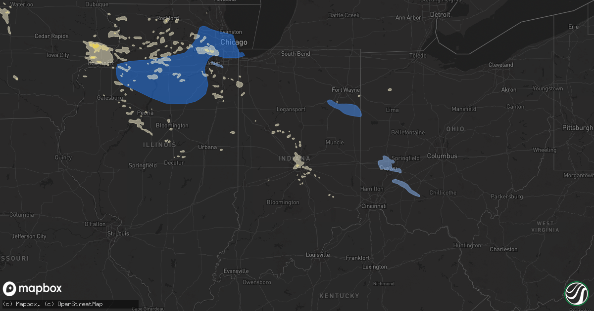
Hail Map in Indiana on July 14, 2024
Get this storm
July 14 map
$229
one time, instant access
Download today. No call, no setup
Keep the $229
Bought the map and want the full workflow? Apply the entire $229 to a subscription within 7 days. None of it is wasted.
Every map, not just this one
This buys you this map. Subscription and you get every map we run, in the markets you choose from a few cities to whole states to nationwide. Plus real-time alerts the moment a storm fires.
Contact data
Name, contact info, occupancy, even credit band for addresses in the footprint. You go from where it hit to who to call.
Become the source they trust
Unlimited branding weather history reports on demand. You already have the documented answer ready for the property owner, and you are the one who showed up with it.
Property data and RoofTrace estimates
Pull up any address you have got, its value and the exact code rules for that jurisdiction, straight from One Click Code. Then RoofTrace estimates the squares, pitch, and roof value, priced the way you price.
Storm reports in Indiana
Indiana
| Date | Description |
|---|---|
| 07/14/20241:31 PM CDT | Corrects previous tstm wnd dmg report from dublin. Three-inch branch blown down near the intersection of johnson street and maple street. Time estimated from radar data |
| 07/14/20241:31 PM CDT | Large tree blown down near the intersection of pearl street and main street. Time estimated from radar data. |
| 07/14/20241:24 PM CDT | 30 to 40 properties with tree damage in cambridge city. Several homes were damaged due to fallen trees. |
| 07/14/202412:40 PM CDT | Delayed report of large trees down and power poles down in the avondale area. Time estimated from radar. |
| 07/14/202411:53 AM CDT | Large tree limbed fell onto a shed at a residence on n. Goshen road. Time estimated from radar. |
| 07/14/202411:52 AM CDT | Tree down blocking the road on division road... Just east of meridian road. Time estimated from radar. |
| 07/14/202411:47 AM CDT | Several healthy trees snapped or downed. One travel trailer tipped over on its side. |
| 07/14/202411:47 AM CDT | Large tree down on oak steet. |
| 07/14/202411:45 AM CDT | Large tree down on gardendale avenue. Time estimated from radar. |
| 07/14/202411:41 AM CDT | Large tree down on river road at rangeline road. Time estimated from radar. |
| 07/14/202411:24 AM CDT | Power pole downed on county road 300 s near burlington avenue. Time estimated from radar. |
| 07/14/202411:22 AM CDT | Multiple trees down in south whitley area. |
| 07/14/202411:16 AM CDT | Delayed report or tree and power lines down near 300 e 150 n. |
| 07/14/202411:12 AM CDT | Large tree limbs down including a ten inch in diameter branch near adams and church roads. Time estimated from radar. |
| 07/14/202411:10 AM CDT | Large tree down blocking roadway at us 35 and delaware road. Time estimated from radar. |
| 07/14/202411:10 AM CDT | Tree down blocking roadway near france park. Time estimated from radar. |
| 07/14/20249:39 AM CDT | Measured on a personal weather station. |
| 07/14/20242:30 AM CDT | Tree downed. |
| 07/14/202412:18 AM CDT | Peak gust measured on personal weather station. |
| 07/14/202412:15 AM CDT | Report from mping: small limbs of 1 to 3 inch diameter broken off. |
All States Impacted by Hail Map on July 14, 2024
Cities Impacted by Hail Map on July 14, 2024
- Ashton, IL
- Oregon, IL
- Chana, IL
- Rochelle, IL
- Mchenry, IL
- Grant Park, IL
- Kempton, PA
- Shoemakersville, PA
- Hamburg, PA
- New Tripoli, PA
- Fleetwood, PA
- Attica, IN
- Lafayette, IN
- Delphi, IN
- Dayton, IN
- Blandon, PA
- Bringhurst, IN
- Frankfort, IN
- Mulberry, IN
- Kutztown, PA
- Markle, IN
- Rossville, IN
- Kirklin, IN
- Green Lane, PA
- Harleysville, PA
- Perkiomenville, PA
- Huntington, IN
- Michigantown, IN
- Telford, PA
- Schwenksville, PA
- Sheridan, IN
- Bernville, PA
- Arcadia, IN
- Atlanta, IN
- Cloverdale, IN
- Monroeville, IN
- Cicero, IN
- Westfield, IN
- Sellersville, PA
- Zieglerville, PA
- Indianapolis, IN
- Zionsville, IN
- Carmel, IN
- Souderton, PA
- Quakertown, PA
- Elverson, PA
- Glenmoore, PA
- Hatfield, PA
- Lansdale, PA
- Ottawa, OH
- Continental, OH
- De Kalb, MS
- Downingtown, PA
- Chester Springs, PA
- Blue Bell, PA
- Norristown, PA
- North Wales, PA
- New Palestine, IN
- Scooba, MS
- New Brunswick, NJ
- Piscataway, NJ
- Highland Park, NJ
- Somerset, NJ
- Shuqualak, MS
- Edison, NJ
- South Plainfield, NJ
- Greenwood, IN
- Fountaintown, IN
- Fairland, IN
- Davidsonville, MD
- Edgewater, MD
- Flourtown, PA
- Fort Washington, PA
- Ambler, PA
- Forest, IN
- Shelbyville, IN
- Tipton, IN
- Kempton, IN
- Coatesville, PA
- Bargersville, IN
- Franklin, IN
- Metuchen, NJ
- York, AL
- Livingston, AL
- Morgantown, IN
- Exton, PA
- Silver Springs, FL
- Narvon, PA
- Gap, PA
- Parkesburg, PA
- Honey Brook, PA
- Meridian, MS
- Greensburg, IN
- Thorndale, PA
- Harwood, MD
- Riva, MD
- Atglen, PA
- West Milton, OH
- Tipp City, OH
- Vandalia, OH
- Dayton, OH
- Englewood, OH
- Alpha, OH
- Xenia, OH
- Fairborn, OH
- Warren, IN
- Bluffton, IN
- Uniondale, IN
- Liberty Center, IN
- Decatur, IN
- Ossian, IN
- Craigville, IN
- Berne, IN
- Monroe, IN
- Geneva, IN
- Rockford, OH
- Willshire, OH
- Bryn Mawr, PA
- Gladwyne, PA
- Cochranville, PA
- Christiana, PA
- Deland, FL
- Cuba, AL
- Shady Side, MD
- Lisman, AL
- Butler, AL
- Saint Cloud, WI
- Malone, WI
- Fort McCoy, FL
- Oregonia, OH
- Waynesville, OH
- Wilmington, OH
- Harveysburg, OH
- Clarksville, OH
- New Vienna, OH
- Leesburg, OH
- Hillsboro, OH
- Deltona, FL
- New Carlisle, OH
- New Lebanon, OH
- Brookville, OH
- Clayton, OH
- Essington, PA
- Prospect Park, PA
- Norwood, PA
- Ridley Park, PA
- Pine Valley, CA
- Goose Creek, SC
- Twentynine Palms, CA
- Gibsonton, FL
- Amory, MS
- Bel Air, MD
- Toxey, AL
- Gatesville, NC
- Nettleton, MS
- Meadview, AZ
- Cofield, NC
- Harrellsville, NC
- Tyner, NC
- Hobbsville, NC
- Hanahan, SC
- Tampa, FL
- Riverview, FL
- Oviedo, FL
- Winter Park, FL
- Orlando, FL
- Prescott, AZ
- Seligman, AZ
- Mountain Center, CA
- Seffner, FL
- Dover, FL
- Peach Springs, AZ
- Ishpeming, MI
- Negaunee, MI
- Edenton, NC
- Willcox, AZ
- Anza, CA
- Put In Bay, OH
- Charleston, SC
- North Charleston, SC
- Palmer, MI
- Glenmora, LA
- Hertford, NC
- Pitkin, LA
- Patagonia, AZ
- Forest, MS
- Gwinn, MI
- Skandia, MI
- Millry, AL
- Lena, MS
- Whiteriver, AZ
- Charleston Afb, SC
- Sonoita, AZ
- Clermont, FL
- Payson, AZ
- Rock, MI
- Colerain, NC
- Frankville, AL
- Palm Desert, CA
- Sherwood, ND
- Oakdale, LA
- Elizabeth, LA
- Summerville, SC
- Mohall, ND
- Antler, ND
- Singer, LA
- Saint Stephens, AL
- Peridot, AZ
- Rio Rico, AZ
- Padroni, CO
- Tubac, AZ
- Wellsburg, IA
- Iron River, MI
- Kingman, AZ
- Grundy Center, IA
- Crystal Falls, MI
- Chatom, AL
- State Line, MS
- Big Bear City, CA
- Richton, MS
- Leakesville, MS
- Reinbeck, IA
- Hayward, WI
- Westhope, ND
- Rapid River, MI
- Fruitdale, AL
- Sterling, CO
- Pine, AZ
- Nahunta, GA
- Watersmeet, MI
- Sedona, AZ
- Benson, AZ
- Neely, MS
- Tucson, AZ
- Maxbass, ND
- Lincoln, IA
- Gladbrook, IA
- Lindon, CO
- Nogales, AZ
- Morrison, IA
- Dike, IA
- Sagola, MI
- Otis, CO
- Holland, IA
- Potter, NE
- Memphis, TN
- Little Lake, MI
- McLain, MS
- Brandon, FL
- Vail, AZ
- Woodrow, CO
- Stockton, AL
- Little River, AL
- Blue Mounds, WI
- Galena, IL
- Houlka, MS
- Houston, MS
- Mount Vernon, AL
- Foster City, MI
- Garwin, IA
- Toledo, IA
- Beaumont, MS
- New Augusta, MS
- Brooklyn, MS
- Iron Mountain, MI
- Aurora, NC
- Mount Horeb, WI
- Black Earth, WI
- Mazomanie, WI
- Goose Lake, IA
- Elizabeth, IL
- Anton, CO
- Cope, CO
- Stockton, IL
- Wheatland, IA
- Calamus, IA
- Cross Plains, WI
- Hanover, IL
- Saint Petersburg, FL
- Felch, MI
- Souris, ND
- Eagle River, WI
- Madison, WI
- Charlotte, IA
- Akron, CO
- Donahue, IA
- Long Grove, IA
- Lake Tomahawk, WI
- Newburg, ND
- Three Lakes, WI
- Perronville, MI
- Middleton, WI
- Dane, WI
- Freeport, IL
- German Valley, IL
- Darlington, WI
- Shullsburg, WI
- Grand Mound, IA
- Bainville, MT
- Rhinelander, WI
- Poplarville, MS
- Lumberton, MS
- Dixon, IA
- De Witt, IA
- Clinton, IA
- Gratiot, WI
- Rimrock, AZ
- Waunakee, WI
- Yuma, CO
- Bryant, IA
- Mount Carroll, IL
- Barneveld, WI
- Arena, WI
- Camp Verde, AZ
- Alamo, ND
- Zahl, ND
- Kramer, ND
- Joes, CO
- Ernul, NC
- New Bern, NC
- Williston, ND
- Mount Lemmon, AZ
- Groveland, FL
- Purvis, MS
- Hattiesburg, MS
- Verona, WI
- Winslow, IL
- Bantry, ND
- Upham, ND
- Willow City, ND
- Browntown, WI
- Oregon, WI
- Bottineau, ND
- Casselberry, FL
- Winter Springs, FL
- Traer, IA
- South Wayne, WI
- Arriba, CO
- Flagler, CO
- Brodhead, WI
- Cherry Valley, IL
- Rockford, IL
- Winnebago, IL
- Byron, IL
- Sauk City, WI
- Stoughton, WI
- Cedar Falls, IA
- Belvidere, IL
- Kirkland, IL
- Woodman, WI
- Harleyville, SC
- Dorchester, SC
- Parkersburg, IA
- Crawford, NE
- Whitney, NE
- Pecatonica, IL
- Stillman Valley, IL
- Cuba City, WI
- Belmont, WI
- Albany, WI
- Towner, ND
- Seibert, CO
- Milledgeville, IL
- Chadwick, IL
- Morrison, IL
- Saint George, SC
- Ridott, IL
- Thomson, IL
- Sabula, IA
- Marana, AZ
- Rugby, ND
- Stratton, CO
- Vona, CO
- Waverly, IA
- Janesville, IA
- Shell Rock, IA
- Deering, ND
- Fulton, IL
- Erie, IL
- Oracle, AZ
- Bridgeport, NE
- Prentiss, MS
- Monroe Center, IL
- Monroe, WI
- Mount Morris, IL
- Monticello, WI
- Juda, WI
- Esmond, IL
- Ray, ND
- Darien, WI
- Avalon, WI
- Trenary, MI
- Milton, WI
- Janesville, WI
- Lindenwood, IL
- Holcomb, IL
- Davis Junction, IL
- Watford City, ND
- Epping, ND
- Sterling, IL
- Tioga, ND
- Fenton, IL
- Eloy, AZ
- Newhebron, MS
- Trenton, ND
- Alexander, ND
- Keene, ND
- New Town, ND
- Stanley, ND
- Red Rock, AZ
- Picacho, AZ
- Florence, AZ
- Dixon, IL
- Lyndon, IL
- Malta, IL
- Steward, IL
- Dewey, AZ
- Humboldt, AZ
- Fremont, IA
- Granville, ND
- New Boston, IL
- Delavan, WI
- Whitewater, WI
- Lake Geneva, WI
- Illinois City, IL
- Prescott Valley, AZ
- Rose Hill, IA
- Oskaloosa, IA
- Elkhorn, WI
- Glenburn, ND
- Franklin Grove, IL
- Joy, IL
- Lee, IL
- Mayer, AZ
- Maple Park, IL
- Elburn, IL
- Hampshire, IL
- Elgin, IL
- Saint Charles, IL
- Kenmare, ND
- Waterman, IL
- Shabbona, IL
- Arizona City, AZ
- Dekalb, IL
- Carriere, MS
- Lost Nation, IA
- Delmar, IA
- White Earth, ND
- Sugar Grove, IL
- Big Rock, IL
- Karlsruhe, ND
- Palermo, ND
- Casa Grande, AZ
- Hinckley, IL
- Lowden, IA
- Preston, IA
- Picayune, MS
- Stennis Space Center, MS
- Miles, IA
- Drake, ND
- Berthold, ND
- Aurora, IL
- West Chicago, IL
- Naperville, IL
- Warrenville, IL
- Teeds Grove, IA
- Stockton, IA
- New Liberty, IA
- Black Canyon City, AZ
- West Brooklyn, IL
- Batavia, IL
- Geneva, IL
- Wayne, IL
- Paw Paw, IL
- Earlville, IL
- Bristol, IL
- Oswego, IL
- Montgomery, IL
- Yorkville, IL
- Tolley, ND
- Maricopa, AZ
- Parshall, ND
- Walcott, IA
- Davenport, IA
- McCausland, IA
- Camanche, IA
- Durant, IA
- Princeton, IA
- Eldridge, IA
- Walnut, IL
- Harmon, IL
- Deer Grove, IL
- Plaza, ND
- Plainfield, IL
- Bay Saint Louis, MS
- Sublette, IL
- Garrison, ND
- Amboy, IL
- Ohio, IL
- Woodridge, IL
- Lisle, IL
- Downers Grove, IL
- Bolingbrook, IL
- Cordova, IL
- Compton, IL
- La Moille, IL
- Mendota, IL
- Blue Grass, IA
- East Moline, IL
- Port Byron, IL
- Bettendorf, IA
- Le Claire, IA
- Pleasant Valley, IA
- Rapids City, IL
- Hampton, IL
- Albany, IL
- Romeoville, IL
- Lemont, IL
- Darien, IL
- Lockport, IL
- Prophetstown, IL
- Congress, AZ
- Morristown, AZ
- Coal Valley, IL
- Geneseo, IL
- Hillsdale, IL
- Silvis, IL
- Rock Island, IL
- Moline, IL
- Carbon Cliff, IL
- Rock Falls, IL
- Bartlett, IL
- Hoffman Estates, IL
- Newark, IL
- North Aurora, IL
- Mooseheart, IL
- Plano, IL
- Sandwich, IL
- Gilberts, IL
- Barrington, IL
- Sheridan, IL
- Somonauk, IL
- Wasco, IL
- Streamwood, IL
- Carpentersville, IL
- Dundee, IL
- South Elgin, IL
- Millbrook, IL
- Algonquin, IL
- Hanover Park, IL
- Roselle, IL
- Carol Stream, IL
- Glen Ellyn, IL
- Glendale Heights, IL
- Bloomingdale, IL
- Winfield, IL
- Wheaton, IL
- Schaumburg, IL
- Broadview, IL
- Westmont, IL
- La Grange Park, IL
- Elk Grove Village, IL
- Hinsdale, IL
- Westchester, IL
- Elmhurst, IL
- Oak Park, IL
- Berkeley, IL
- Bensenville, IL
- Villa Park, IL
- Stone Park, IL
- Lincolnwood, IL
- Addison, IL
- Maywood, IL
- Brookfield, IL
- Oak Brook, IL
- Riverside, IL
- Lombard, IL
- Melrose Park, IL
- Medinah, IL
- River Forest, IL
- Itasca, IL
- Hines, IL
- Arlington Heights, IL
- Bellwood, IL
- Hillside, IL
- Park Ridge, IL
- Franklin Park, IL
- River Grove, IL
- Rolling Meadows, IL
- Western Springs, IL
- Mount Prospect, IL
- Chicago, IL
- Willowbrook, IL
- Des Plaines, IL
- Wood Dale, IL
- La Grange, IL
- Forest Park, IL
- Elmwood Park, IL
- Clarendon Hills, IL
- Skokie, IL
- Niles, IL
- Harwood Heights, IL
- Schiller Park, IL
- Lyons, IL
- Berwyn, IL
- Palatine, IL
- Harvey, IL
- Justice, IL
- Palos Hills, IL
- South Holland, IL
- Crestwood, IL
- Palos Heights, IL
- Homewood, IL
- Oak Forest, IL
- Bridgeview, IL
- Midlothian, IL
- Blue Island, IL
- Robbins, IL
- Tinley Park, IL
- Country Club Hills, IL
- Hickory Hills, IL
- Alsip, IL
- Thornton, IL
- Riverdale, IL
- Dolton, IL
- Glenwood, IL
- Orland Park, IL
- Chicago Heights, IL
- Hometown, IL
- Lansing, IL
- Markham, IL
- Burbank, IL
- Oak Lawn, IL
- Posen, IL
- Hazel Crest, IL
- Palos Park, IL
- Worth, IL
- Evergreen Park, IL
- Chicago Ridge, IL
- Flossmoor, IL
- Cicero, IL
- Summit Argo, IL
- Willow Springs, IL
- Homer Glen, IL
- Calumet City, IL
- Hazen, ND
- Atkinson, IL
- Annawan, IL
- Arlington, IL
- Princeton, IL
- Tiskilwa, IL
- Wyanet, IL
- Shelbyville, MI
- Van Orin, IL
- Colona, IL
- Phoenix, AZ
- Malden, IL
- Middleville, MI
- Wayland, MI
- Roseglen, ND
- Ryder, ND
- Toulon, IL
- Stanton, ND
- Paradise Valley, AZ
- Scottsdale, AZ
- Bureau, IL
- Washburn, ND
- Spring Valley, IL
- Neponset, IL
- Wilmington, IL
- Morris, IL
- Coal City, IL
- Elwood, IL
- Channahon, IL
- Hammond, IN
- Whiting, IN
- Gary, IN
- East Chicago, IN
- Leland, IL
- Osco, IL
- Putnam, IL
- New Bedford, IL
- Buda, IL
- Hooppole, IL
- Kewanee, IL
- Mineral, IL
- Galva, IL
- Millington, IL
- Tampico, IL
- Cambridge, IL
- Manlius, IL
- Sheffield, IL
- Bradford, IL
- Triumph, IL
- Hennepin, IL
- Dalzell, IL
- Troy Grove, IL
- Cherry, IL
- Mark, IL
- Peru, IL
- Ladd, IL
- Granville, IL
- Dover, IL
- Ottawa, IL
- Oglesby, IL
- Utica, IL
- Depue, IL
- La Salle, IL
- Serena, IL
- Seatonville, IL
- Rio Verde, AZ
- Altona, IL
- Woodhull, IL
- Manteno, IL
- Peotone, IL
- Cave Creek, AZ
- Dorr, MI
- Grand Ridge, IL
- Esmond, ND
- Maddock, ND
- Anamoose, ND
- Harvey, ND
- Fessenden, ND
- Martin, ND
- Beulah, ND
- Underwood, ND
- Standard, IL
- McNabb, IL
- Cedar Point, IL
- Wedron, IL
- Seneca, IL
- Marseilles, IL
- Tonica, IL
- Lostant, IL
- Minooka, IL
- Joliet, IL
- Streator, IL
- New Rockford, ND
- Cathay, ND
- Lake Village, IN
- Momence, IL
- Lowell, IN
- Sheyenne, ND
- Victoria, IL
- La Fayette, IL
- Byron Center, MI
- Turtle Lake, ND
- Balfour, ND
- Carrington, ND
- Wickenburg, AZ
- Galesburg, IL
- Alexis, IL
- Gerlaw, IL
- Grandville, MI
- Schneider, IN
- Ransom, IL
- Gilson, IL
- Williamsfield, IL
- Dahinda, IL
- Wyoming, MI
- Grand Rapids, MI
- Caledonia, MI
- Alto, MI
- Chandler, AZ
- Morocco, IN
- Peoria, IL
- Kankakee, IL
- Bonfield, IL
- Chebanse, IL
- Yates City, IL
- Herscher, IL
- Clifton, IL
- Metamora, IL
- Washington, IL
- Wyoming, IL
- Bishop Hill, IL
- Shorewood, IL
- Henry, IL
- Dana, IL
- Leonore, IL
- Graymont, IL
- Minonk, IL
- Chillicothe, IL
- Cornell, IL
- Lowpoint, IL
- Pontiac, IL
- Dwight, IL
- Toluca, IL
- Verona, IL
- Gardner, IL
- Rutland, IL
- Flanagan, IL
- Blackstone, IL
- Lacon, IL
- Long Point, IL
- Roanoke, IL
- Speer, IL
- La Rose, IL
- Wenona, IL
- Magnolia, IL
- Sparland, IL
- Ancona, IL
- Kinsman, IL
- Gridley, IL
- Washburn, IL
- Varna, IL
- Chenoa, IL
- Odell, IL
- Mazon, IL
- Benson, IL
- Braidwood, IL
- Cabery, IL
- Essex, IL
- Emington, IL
- Braceville, IL
- Reddick, IL
- Campus, IL
- Buckingham, IL
- South Wilmington, IL
- Saunemin, IL
- Elmwood, IL
- Canton, IL
- Carlock, IL
- Bloomington, IL
- Farmington, IL
- Ada, MI
- Lowell, MI
- Glasford, IL
- Mapleton, IL
- Trivoli, IL
- Buckeye, AZ
- Ashkum, IL
- Mcclusky, ND
- Goodrich, ND
- Normal, IL
- Denhoff, ND
- South Pekin, IL
- Kingston Mines, IL
- Manito, IL
- Pekin, IL
- Wing, ND
- Ypsilanti, ND
- McLean, IL
- Litchville, ND
- Marion, ND
- Tuttle, ND
- Shirley, IL
- Bowdon, ND
- Waynesville, IL
- Robinson, ND
- Kathryn, ND
- Hurdsfield, ND
- Clinton, IL
- Sykeston, ND
- Woodworth, ND
- Jamestown, ND
- Dawson, ND
- Pingree, ND
- Eagle, MI
- Dewitt, MI
- Pettibone, ND
- Cisco, IL
- Argenta, IL
- Templeton, IN
- Oxford, IN
- Otterbein, IN
- Green Valley, IL
- Rossville, IL
- Courtenay, ND
- Wimbledon, ND
- Delavan, IL
- Midland, SD
- Tappen, ND
- Oreana, IL
- Saint Johns, MI
- Homer, IL
- Fairmount, IL
- Cleveland, ND
- Medina, ND
- Fithian, IL
- Cerro Gordo, IL
- Spiritwood, ND
- Sanborn, ND
- Valley City, ND
- Decatur, IL
- Forsyth, IL
- Jud, ND
- Montpelier, ND
- Emden, IL
- Milbank, SD
- Big Stone City, SD
- Nome, ND
- Bellingham, MN
- Fingal, ND
- Marietta, MN
- Fairmount, ND
- Wahpeton, ND
- Oriska, ND
- Onida, SD
- Howell, MI
- Madison, MN
- Webster, SD
- Enderlin, ND
- Odessa, MN
- Campbell, MN
- Sisseton, SD
- Tintah, MN
- Milnor, ND
- Claire City, SD
- Elbow Lake, MN
- Norcross, MN
- Lidgerwood, ND
- Veblen, SD
- Dawson, MN
- Montevideo, MN
- Waubay, SD
- Barney, ND
- Wyndmere, ND
- Sheldon, ND
- Leonard, ND
- Sayreville, NJ
- Hankinson, ND
- Ortley, SD
- Colonia, NJ
- Lisbon, ND
- Fort Ransom, ND
- Cayuga, ND
- Summit, SD
- Twin Brooks, SD
- Clarkfield, MN
- Marvin, SD
- Boyd, MN
- Granite Falls, MN
- Parlin, NJ
- Echo, MN
- Miller, SD
- Walcott, ND
- Orient, SD
- Sacred Heart, MN
- Belview, MN
- Wood Lake, MN
- Kindred, ND
- Redwood Falls, MN
- Renville, MN
- Clements, MN
- Morton, MN
- Morgan, MN
- Appleton, MN
- Sleepy Eye, MN
- Wheaton, MN
- Maynard, MN
- Donnelly, MN
- New Ulm, MN
- Herman, MN
- Dumont, MN
- Chokio, MN
- Alberta, MN
- Morris, MN
- Hanley Falls, MN
- Holloway, MN
- Hancock, MN
- Vesta, MN
- Franklin, MN
- Hanska, MN
- Danvers, MN
- Clontarf, MN
- Benson, MN
- Seaforth, MN
- Wabasso, MN
- Murdock, MN
- Kerkhoven, MN
- Ross, ND
- New Lenox, IL
- Manhattan, IL
- Frankfort, IL


