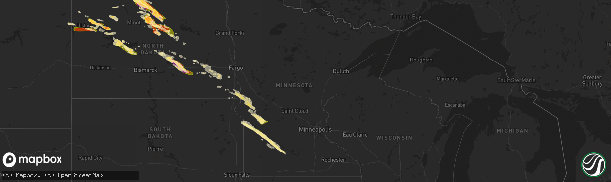
Hail Map in Minnesota on July 14, 2024
The weather event in Minnesota on July 14, 2024 includes Wind and Hail maps. 25 states and 975 cities were impacted and suffered possible damage. The total estimated number of properties impacted is 14,951.
Want more than just the map?
Turn this storm into a full workflow.
- Owner + property data so you know who to knock
- OnDemand branded weather history reports to win the "did we even have hail?" argument
- RoofTrace estimate so reps stop guessing numbers at the door
Bought this map? Upgrade within 7 days and we'll credit the $230. (10-15 min setup call)
Wind
Hail
14,951
Estimated number of impacted properties by a 1.00" hail or larger0
Estimated number of impacted properties by a 1.75" hail or larger0
Estimated number of impacted properties by a 2.50" hail or largerStorm reports in Minnesota
Minnesota
| Date | Description |
|---|---|
| 07/14/20246:55 AM CDT | Semi was blown off highway 29 near 120th st se. |
| 07/14/20245:49 AM CDT | Report from mping: quarter |
| 07/14/20245:42 AM CDT | Public report of crop damage from hail and wind around the herman area in southwest grant county including striping of corn. Time estimated based on radar. |
| 07/14/20245:29 AM CDT | A local report indicates 1.25 inch wind near Morgan |
| 07/14/20245:08 AM CDT | Report from mping: half dollar |
| 07/14/20244:30 AM CDT | Report from mping: half dollar |
All States Impacted by Hail Map on July 14, 2024
Cities Impacted by Hail Map on July 14, 2024
- Ashton, IL
- Oregon, IL
- Chana, IL
- Rochelle, IL
- Mchenry, IL
- Grant Park, IL
- Kempton, PA
- Shoemakersville, PA
- Hamburg, PA
- New Tripoli, PA
- Fleetwood, PA
- Attica, IN
- Lafayette, IN
- Delphi, IN
- Dayton, IN
- Blandon, PA
- Bringhurst, IN
- Frankfort, IN
- Mulberry, IN
- Kutztown, PA
- Markle, IN
- Rossville, IN
- Kirklin, IN
- Green Lane, PA
- Harleysville, PA
- Perkiomenville, PA
- Huntington, IN
- Michigantown, IN
- Telford, PA
- Schwenksville, PA
- Sheridan, IN
- Bernville, PA
- Arcadia, IN
- Atlanta, IN
- Cloverdale, IN
- Monroeville, IN
- Cicero, IN
- Westfield, IN
- Sellersville, PA
- Zieglerville, PA
- Indianapolis, IN
- Zionsville, IN
- Carmel, IN
- Souderton, PA
- Quakertown, PA
- Elverson, PA
- Glenmoore, PA
- Hatfield, PA
- Lansdale, PA
- Ottawa, OH
- Continental, OH
- De Kalb, MS
- Downingtown, PA
- Chester Springs, PA
- Blue Bell, PA
- Norristown, PA
- North Wales, PA
- New Palestine, IN
- Scooba, MS
- New Brunswick, NJ
- Piscataway, NJ
- Highland Park, NJ
- Somerset, NJ
- Shuqualak, MS
- Edison, NJ
- South Plainfield, NJ
- Greenwood, IN
- Fountaintown, IN
- Fairland, IN
- Davidsonville, MD
- Edgewater, MD
- Flourtown, PA
- Fort Washington, PA
- Ambler, PA
- Forest, IN
- Shelbyville, IN
- Tipton, IN
- Kempton, IN
- Coatesville, PA
- Bargersville, IN
- Franklin, IN
- Metuchen, NJ
- York, AL
- Livingston, AL
- Morgantown, IN
- Exton, PA
- Silver Springs, FL
- Narvon, PA
- Gap, PA
- Parkesburg, PA
- Honey Brook, PA
- Meridian, MS
- Greensburg, IN
- Thorndale, PA
- Harwood, MD
- Riva, MD
- Atglen, PA
- West Milton, OH
- Tipp City, OH
- Vandalia, OH
- Dayton, OH
- Englewood, OH
- Alpha, OH
- Xenia, OH
- Fairborn, OH
- Warren, IN
- Bluffton, IN
- Uniondale, IN
- Liberty Center, IN
- Decatur, IN
- Ossian, IN
- Craigville, IN
- Berne, IN
- Monroe, IN
- Geneva, IN
- Rockford, OH
- Willshire, OH
- Bryn Mawr, PA
- Gladwyne, PA
- Cochranville, PA
- Christiana, PA
- Deland, FL
- Cuba, AL
- Shady Side, MD
- Lisman, AL
- Butler, AL
- Saint Cloud, WI
- Malone, WI
- Fort McCoy, FL
- Oregonia, OH
- Waynesville, OH
- Wilmington, OH
- Harveysburg, OH
- Clarksville, OH
- New Vienna, OH
- Leesburg, OH
- Hillsboro, OH
- Deltona, FL
- New Carlisle, OH
- New Lebanon, OH
- Brookville, OH
- Clayton, OH
- Essington, PA
- Prospect Park, PA
- Norwood, PA
- Ridley Park, PA
- Pine Valley, CA
- Goose Creek, SC
- Twentynine Palms, CA
- Gibsonton, FL
- Amory, MS
- Bel Air, MD
- Toxey, AL
- Gatesville, NC
- Nettleton, MS
- Meadview, AZ
- Cofield, NC
- Harrellsville, NC
- Tyner, NC
- Hobbsville, NC
- Hanahan, SC
- Tampa, FL
- Riverview, FL
- Oviedo, FL
- Winter Park, FL
- Orlando, FL
- Prescott, AZ
- Seligman, AZ
- Mountain Center, CA
- Seffner, FL
- Dover, FL
- Peach Springs, AZ
- Ishpeming, MI
- Negaunee, MI
- Edenton, NC
- Willcox, AZ
- Anza, CA
- Put In Bay, OH
- Charleston, SC
- North Charleston, SC
- Palmer, MI
- Glenmora, LA
- Hertford, NC
- Pitkin, LA
- Patagonia, AZ
- Forest, MS
- Gwinn, MI
- Skandia, MI
- Millry, AL
- Lena, MS
- Whiteriver, AZ
- Charleston Afb, SC
- Sonoita, AZ
- Clermont, FL
- Payson, AZ
- Rock, MI
- Colerain, NC
- Frankville, AL
- Palm Desert, CA
- Sherwood, ND
- Oakdale, LA
- Elizabeth, LA
- Summerville, SC
- Mohall, ND
- Antler, ND
- Singer, LA
- Saint Stephens, AL
- Peridot, AZ
- Rio Rico, AZ
- Padroni, CO
- Tubac, AZ
- Wellsburg, IA
- Iron River, MI
- Kingman, AZ
- Grundy Center, IA
- Crystal Falls, MI
- Chatom, AL
- State Line, MS
- Big Bear City, CA
- Richton, MS
- Leakesville, MS
- Reinbeck, IA
- Hayward, WI
- Westhope, ND
- Rapid River, MI
- Fruitdale, AL
- Sterling, CO
- Pine, AZ
- Nahunta, GA
- Watersmeet, MI
- Sedona, AZ
- Benson, AZ
- Neely, MS
- Tucson, AZ
- Maxbass, ND
- Lincoln, IA
- Gladbrook, IA
- Lindon, CO
- Nogales, AZ
- Morrison, IA
- Dike, IA
- Sagola, MI
- Otis, CO
- Holland, IA
- Potter, NE
- Memphis, TN
- Little Lake, MI
- McLain, MS
- Brandon, FL
- Vail, AZ
- Woodrow, CO
- Stockton, AL
- Little River, AL
- Blue Mounds, WI
- Galena, IL
- Houlka, MS
- Houston, MS
- Mount Vernon, AL
- Foster City, MI
- Garwin, IA
- Toledo, IA
- Beaumont, MS
- New Augusta, MS
- Brooklyn, MS
- Iron Mountain, MI
- Aurora, NC
- Mount Horeb, WI
- Black Earth, WI
- Mazomanie, WI
- Goose Lake, IA
- Elizabeth, IL
- Anton, CO
- Cope, CO
- Stockton, IL
- Wheatland, IA
- Calamus, IA
- Cross Plains, WI
- Hanover, IL
- Saint Petersburg, FL
- Felch, MI
- Souris, ND
- Eagle River, WI
- Madison, WI
- Charlotte, IA
- Akron, CO
- Donahue, IA
- Long Grove, IA
- Lake Tomahawk, WI
- Newburg, ND
- Three Lakes, WI
- Perronville, MI
- Middleton, WI
- Dane, WI
- Freeport, IL
- German Valley, IL
- Darlington, WI
- Shullsburg, WI
- Grand Mound, IA
- Bainville, MT
- Rhinelander, WI
- Poplarville, MS
- Lumberton, MS
- Dixon, IA
- De Witt, IA
- Clinton, IA
- Gratiot, WI
- Rimrock, AZ
- Waunakee, WI
- Yuma, CO
- Bryant, IA
- Mount Carroll, IL
- Barneveld, WI
- Arena, WI
- Camp Verde, AZ
- Alamo, ND
- Zahl, ND
- Kramer, ND
- Joes, CO
- Ernul, NC
- New Bern, NC
- Williston, ND
- Mount Lemmon, AZ
- Groveland, FL
- Purvis, MS
- Hattiesburg, MS
- Verona, WI
- Winslow, IL
- Bantry, ND
- Upham, ND
- Willow City, ND
- Browntown, WI
- Oregon, WI
- Bottineau, ND
- Casselberry, FL
- Winter Springs, FL
- Traer, IA
- South Wayne, WI
- Arriba, CO
- Flagler, CO
- Brodhead, WI
- Cherry Valley, IL
- Rockford, IL
- Winnebago, IL
- Byron, IL
- Sauk City, WI
- Stoughton, WI
- Cedar Falls, IA
- Belvidere, IL
- Kirkland, IL
- Woodman, WI
- Harleyville, SC
- Dorchester, SC
- Parkersburg, IA
- Crawford, NE
- Whitney, NE
- Pecatonica, IL
- Stillman Valley, IL
- Cuba City, WI
- Belmont, WI
- Albany, WI
- Towner, ND
- Seibert, CO
- Milledgeville, IL
- Chadwick, IL
- Morrison, IL
- Saint George, SC
- Ridott, IL
- Thomson, IL
- Sabula, IA
- Marana, AZ
- Rugby, ND
- Stratton, CO
- Vona, CO
- Waverly, IA
- Janesville, IA
- Shell Rock, IA
- Deering, ND
- Fulton, IL
- Erie, IL
- Oracle, AZ
- Bridgeport, NE
- Prentiss, MS
- Monroe Center, IL
- Monroe, WI
- Mount Morris, IL
- Monticello, WI
- Juda, WI
- Esmond, IL
- Ray, ND
- Darien, WI
- Avalon, WI
- Trenary, MI
- Milton, WI
- Janesville, WI
- Lindenwood, IL
- Holcomb, IL
- Davis Junction, IL
- Watford City, ND
- Epping, ND
- Sterling, IL
- Tioga, ND
- Fenton, IL
- Eloy, AZ
- Newhebron, MS
- Trenton, ND
- Alexander, ND
- Keene, ND
- New Town, ND
- Stanley, ND
- Red Rock, AZ
- Picacho, AZ
- Florence, AZ
- Dixon, IL
- Lyndon, IL
- Malta, IL
- Steward, IL
- Dewey, AZ
- Humboldt, AZ
- Fremont, IA
- Granville, ND
- New Boston, IL
- Delavan, WI
- Whitewater, WI
- Lake Geneva, WI
- Illinois City, IL
- Prescott Valley, AZ
- Rose Hill, IA
- Oskaloosa, IA
- Elkhorn, WI
- Glenburn, ND
- Franklin Grove, IL
- Joy, IL
- Lee, IL
- Mayer, AZ
- Maple Park, IL
- Elburn, IL
- Hampshire, IL
- Elgin, IL
- Saint Charles, IL
- Kenmare, ND
- Waterman, IL
- Shabbona, IL
- Arizona City, AZ
- Dekalb, IL
- Carriere, MS
- Lost Nation, IA
- Delmar, IA
- White Earth, ND
- Sugar Grove, IL
- Big Rock, IL
- Karlsruhe, ND
- Palermo, ND
- Casa Grande, AZ
- Hinckley, IL
- Lowden, IA
- Preston, IA
- Picayune, MS
- Stennis Space Center, MS
- Miles, IA
- Drake, ND
- Berthold, ND
- Aurora, IL
- West Chicago, IL
- Naperville, IL
- Warrenville, IL
- Teeds Grove, IA
- Stockton, IA
- New Liberty, IA
- Black Canyon City, AZ
- West Brooklyn, IL
- Batavia, IL
- Geneva, IL
- Wayne, IL
- Paw Paw, IL
- Earlville, IL
- Bristol, IL
- Oswego, IL
- Montgomery, IL
- Yorkville, IL
- Tolley, ND
- Maricopa, AZ
- Parshall, ND
- Walcott, IA
- Davenport, IA
- McCausland, IA
- Camanche, IA
- Durant, IA
- Princeton, IA
- Eldridge, IA
- Walnut, IL
- Harmon, IL
- Deer Grove, IL
- Plaza, ND
- Plainfield, IL
- Bay Saint Louis, MS
- Sublette, IL
- Garrison, ND
- Amboy, IL
- Ohio, IL
- Woodridge, IL
- Lisle, IL
- Downers Grove, IL
- Bolingbrook, IL
- Cordova, IL
- Compton, IL
- La Moille, IL
- Mendota, IL
- Blue Grass, IA
- East Moline, IL
- Port Byron, IL
- Bettendorf, IA
- Le Claire, IA
- Pleasant Valley, IA
- Rapids City, IL
- Hampton, IL
- Albany, IL
- Romeoville, IL
- Lemont, IL
- Darien, IL
- Lockport, IL
- Prophetstown, IL
- Congress, AZ
- Morristown, AZ
- Coal Valley, IL
- Geneseo, IL
- Hillsdale, IL
- Silvis, IL
- Rock Island, IL
- Moline, IL
- Carbon Cliff, IL
- Rock Falls, IL
- Bartlett, IL
- Hoffman Estates, IL
- Newark, IL
- North Aurora, IL
- Mooseheart, IL
- Plano, IL
- Sandwich, IL
- Gilberts, IL
- Barrington, IL
- Sheridan, IL
- Somonauk, IL
- Wasco, IL
- Streamwood, IL
- Carpentersville, IL
- Dundee, IL
- South Elgin, IL
- Millbrook, IL
- Algonquin, IL
- Hanover Park, IL
- Roselle, IL
- Carol Stream, IL
- Glen Ellyn, IL
- Glendale Heights, IL
- Bloomingdale, IL
- Winfield, IL
- Wheaton, IL
- Schaumburg, IL
- Broadview, IL
- Westmont, IL
- La Grange Park, IL
- Elk Grove Village, IL
- Hinsdale, IL
- Westchester, IL
- Elmhurst, IL
- Oak Park, IL
- Berkeley, IL
- Bensenville, IL
- Villa Park, IL
- Stone Park, IL
- Lincolnwood, IL
- Addison, IL
- Maywood, IL
- Brookfield, IL
- Oak Brook, IL
- Riverside, IL
- Lombard, IL
- Melrose Park, IL
- Medinah, IL
- River Forest, IL
- Itasca, IL
- Hines, IL
- Arlington Heights, IL
- Bellwood, IL
- Hillside, IL
- Park Ridge, IL
- Franklin Park, IL
- River Grove, IL
- Rolling Meadows, IL
- Western Springs, IL
- Mount Prospect, IL
- Chicago, IL
- Willowbrook, IL
- Des Plaines, IL
- Wood Dale, IL
- La Grange, IL
- Forest Park, IL
- Elmwood Park, IL
- Clarendon Hills, IL
- Skokie, IL
- Niles, IL
- Harwood Heights, IL
- Schiller Park, IL
- Lyons, IL
- Berwyn, IL
- Palatine, IL
- Harvey, IL
- Justice, IL
- Palos Hills, IL
- South Holland, IL
- Crestwood, IL
- Palos Heights, IL
- Homewood, IL
- Oak Forest, IL
- Bridgeview, IL
- Midlothian, IL
- Blue Island, IL
- Robbins, IL
- Tinley Park, IL
- Country Club Hills, IL
- Hickory Hills, IL
- Alsip, IL
- Thornton, IL
- Riverdale, IL
- Dolton, IL
- Glenwood, IL
- Orland Park, IL
- Chicago Heights, IL
- Hometown, IL
- Lansing, IL
- Markham, IL
- Burbank, IL
- Oak Lawn, IL
- Posen, IL
- Hazel Crest, IL
- Palos Park, IL
- Worth, IL
- Evergreen Park, IL
- Chicago Ridge, IL
- Flossmoor, IL
- Cicero, IL
- Summit Argo, IL
- Willow Springs, IL
- Homer Glen, IL
- Calumet City, IL
- Hazen, ND
- Atkinson, IL
- Annawan, IL
- Arlington, IL
- Princeton, IL
- Tiskilwa, IL
- Wyanet, IL
- Shelbyville, MI
- Van Orin, IL
- Colona, IL
- Phoenix, AZ
- Malden, IL
- Middleville, MI
- Wayland, MI
- Roseglen, ND
- Ryder, ND
- Toulon, IL
- Stanton, ND
- Paradise Valley, AZ
- Scottsdale, AZ
- Bureau, IL
- Washburn, ND
- Spring Valley, IL
- Neponset, IL
- Wilmington, IL
- Morris, IL
- Coal City, IL
- Elwood, IL
- Channahon, IL
- Hammond, IN
- Whiting, IN
- Gary, IN
- East Chicago, IN
- Leland, IL
- Osco, IL
- Putnam, IL
- New Bedford, IL
- Buda, IL
- Hooppole, IL
- Kewanee, IL
- Mineral, IL
- Galva, IL
- Millington, IL
- Tampico, IL
- Cambridge, IL
- Manlius, IL
- Sheffield, IL
- Bradford, IL
- Triumph, IL
- Hennepin, IL
- Dalzell, IL
- Troy Grove, IL
- Cherry, IL
- Mark, IL
- Peru, IL
- Ladd, IL
- Granville, IL
- Dover, IL
- Ottawa, IL
- Oglesby, IL
- Utica, IL
- Depue, IL
- La Salle, IL
- Serena, IL
- Seatonville, IL
- Rio Verde, AZ
- Altona, IL
- Woodhull, IL
- Manteno, IL
- Peotone, IL
- Cave Creek, AZ
- Dorr, MI
- Grand Ridge, IL
- Esmond, ND
- Maddock, ND
- Anamoose, ND
- Harvey, ND
- Fessenden, ND
- Martin, ND
- Beulah, ND
- Underwood, ND
- Standard, IL
- McNabb, IL
- Cedar Point, IL
- Wedron, IL
- Seneca, IL
- Marseilles, IL
- Tonica, IL
- Lostant, IL
- Minooka, IL
- Joliet, IL
- Streator, IL
- New Rockford, ND
- Cathay, ND
- Lake Village, IN
- Momence, IL
- Lowell, IN
- Sheyenne, ND
- Victoria, IL
- La Fayette, IL
- Byron Center, MI
- Turtle Lake, ND
- Balfour, ND
- Carrington, ND
- Wickenburg, AZ
- Galesburg, IL
- Alexis, IL
- Gerlaw, IL
- Grandville, MI
- Schneider, IN
- Ransom, IL
- Gilson, IL
- Williamsfield, IL
- Dahinda, IL
- Wyoming, MI
- Grand Rapids, MI
- Caledonia, MI
- Alto, MI
- Chandler, AZ
- Morocco, IN
- Peoria, IL
- Kankakee, IL
- Bonfield, IL
- Chebanse, IL
- Yates City, IL
- Herscher, IL
- Clifton, IL
- Metamora, IL
- Washington, IL
- Wyoming, IL
- Bishop Hill, IL
- Shorewood, IL
- Henry, IL
- Dana, IL
- Leonore, IL
- Graymont, IL
- Minonk, IL
- Chillicothe, IL
- Cornell, IL
- Lowpoint, IL
- Pontiac, IL
- Dwight, IL
- Toluca, IL
- Verona, IL
- Gardner, IL
- Rutland, IL
- Flanagan, IL
- Blackstone, IL
- Lacon, IL
- Long Point, IL
- Roanoke, IL
- Speer, IL
- La Rose, IL
- Wenona, IL
- Magnolia, IL
- Sparland, IL
- Ancona, IL
- Kinsman, IL
- Gridley, IL
- Washburn, IL
- Varna, IL
- Chenoa, IL
- Odell, IL
- Mazon, IL
- Benson, IL
- Braidwood, IL
- Cabery, IL
- Essex, IL
- Emington, IL
- Braceville, IL
- Reddick, IL
- Campus, IL
- Buckingham, IL
- South Wilmington, IL
- Saunemin, IL
- Elmwood, IL
- Canton, IL
- Carlock, IL
- Bloomington, IL
- Farmington, IL
- Ada, MI
- Lowell, MI
- Glasford, IL
- Mapleton, IL
- Trivoli, IL
- Buckeye, AZ
- Ashkum, IL
- Mcclusky, ND
- Goodrich, ND
- Normal, IL
- Denhoff, ND
- South Pekin, IL
- Kingston Mines, IL
- Manito, IL
- Pekin, IL
- Wing, ND
- Ypsilanti, ND
- McLean, IL
- Litchville, ND
- Marion, ND
- Tuttle, ND
- Shirley, IL
- Bowdon, ND
- Waynesville, IL
- Robinson, ND
- Kathryn, ND
- Hurdsfield, ND
- Clinton, IL
- Sykeston, ND
- Woodworth, ND
- Jamestown, ND
- Dawson, ND
- Pingree, ND
- Eagle, MI
- Dewitt, MI
- Pettibone, ND
- Cisco, IL
- Argenta, IL
- Templeton, IN
- Oxford, IN
- Otterbein, IN
- Green Valley, IL
- Rossville, IL
- Courtenay, ND
- Wimbledon, ND
- Delavan, IL
- Midland, SD
- Tappen, ND
- Oreana, IL
- Saint Johns, MI
- Homer, IL
- Fairmount, IL
- Cleveland, ND
- Medina, ND
- Fithian, IL
- Cerro Gordo, IL
- Spiritwood, ND
- Sanborn, ND
- Valley City, ND
- Decatur, IL
- Forsyth, IL
- Jud, ND
- Montpelier, ND
- Emden, IL
- Milbank, SD
- Big Stone City, SD
- Nome, ND
- Bellingham, MN
- Fingal, ND
- Marietta, MN
- Fairmount, ND
- Wahpeton, ND
- Oriska, ND
- Onida, SD
- Howell, MI
- Madison, MN
- Webster, SD
- Enderlin, ND
- Odessa, MN
- Campbell, MN
- Sisseton, SD
- Tintah, MN
- Milnor, ND
- Claire City, SD
- Elbow Lake, MN
- Norcross, MN
- Lidgerwood, ND
- Veblen, SD
- Dawson, MN
- Montevideo, MN
- Waubay, SD
- Barney, ND
- Wyndmere, ND
- Sheldon, ND
- Leonard, ND
- Sayreville, NJ
- Hankinson, ND
- Ortley, SD
- Colonia, NJ
- Lisbon, ND
- Fort Ransom, ND
- Cayuga, ND
- Summit, SD
- Twin Brooks, SD
- Clarkfield, MN
- Marvin, SD
- Boyd, MN
- Granite Falls, MN
- Parlin, NJ
- Echo, MN
- Miller, SD
- Walcott, ND
- Orient, SD
- Sacred Heart, MN
- Belview, MN
- Wood Lake, MN
- Kindred, ND
- Redwood Falls, MN
- Renville, MN
- Clements, MN
- Morton, MN
- Morgan, MN
- Appleton, MN
- Sleepy Eye, MN
- Wheaton, MN
- Maynard, MN
- Donnelly, MN
- New Ulm, MN
- Herman, MN
- Dumont, MN
- Chokio, MN
- Alberta, MN
- Morris, MN
- Hanley Falls, MN
- Holloway, MN
- Hancock, MN
- Vesta, MN
- Franklin, MN
- Hanska, MN
- Danvers, MN
- Clontarf, MN
- Benson, MN
- Seaforth, MN
- Wabasso, MN
- Murdock, MN
- Kerkhoven, MN
- Ross, ND
- New Lenox, IL
- Manhattan, IL
- Frankfort, IL


