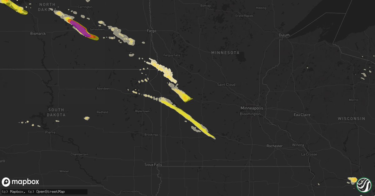
Hail Map on July 14, 2024
Get this storm
July 14 map
$229
one time, instant access
Download today. No call, no setup
Keep the $229
Bought the map and want the full workflow? Apply the entire $229 to a subscription within 7 days. None of it is wasted.
Every map, not just this one
This buys you this map. Subscription and you get every map we run, in the markets you choose from a few cities to whole states to nationwide. Plus real-time alerts the moment a storm fires.
Contact data
Name, contact info, occupancy, even credit band for addresses in the footprint. You go from where it hit to who to call.
Become the source they trust
Unlimited branding weather history reports on demand. You already have the documented answer ready for the property owner, and you are the one who showed up with it.
Property data and RoofTrace estimates
Pull up any address you have got, its value and the exact code rules for that jurisdiction, straight from One Click Code. Then RoofTrace estimates the squares, pitch, and roof value, priced the way you price.
States Impacted by Hail Map on July 14, 2024
Storm reports
Utah
| Date | Description |
|---|---|
| 07/14/20246:10 PM CDT | Mesonet station pc477 palisade lake. |
| 07/14/20246:00 PM CDT | Mesonet station utsom us-89 at mp 254 south manti. |
| 07/14/20245:30 PM CDT | Mesonet station utsla i-70 at salina. |
| 07/14/20245:10 PM CDT | Mesonet station pc482 bull claim hill. |
| 07/13/202411:30 PM CDT | Mesonet station wpk wendover peak. |
| 07/13/202411:10 PM CDT | Mesonet station dpg05 white sage. |
| 07/13/202411:00 PM CDT | Mesonet station dpg23 lower cedar mtn. |
| 07/13/202410:55 PM CDT | Mesonet station lmr lakeside mountain. |
| 07/13/202410:45 PM CDT | Mesonet station wpk wendover peak. |
| 07/13/202410:10 PM CDT | Mesonet station ut32 i-80 at mp 1. |
| 07/13/202410:05 PM CDT | Mesonet station wpoe wendover port of entry. |
| 07/13/202410:01 PM CDT | Mesonet station ur298 15.9 w knolls. |
| 07/13/20249:20 PM CDT | Mesonet station uttp2 i-80 at mp 2 tripod. |
North Dakota
| Date | Description |
|---|---|
| 07/14/20246:40 PM CDT | Late report from the sunday. A few ping pong ball size hail at the beginning... Then smaller hail to follow. Time estimated by radar. |
| 07/14/20245:35 PM CDT | Hail and wind lasted 10 minutes. |
| 07/14/20244:33 AM CDT | Personal weather station rrtclfx in colfax nd reported sustained maximum wind 54 mph with gust to 62 mph. Time acquired from pws website. |
| 07/14/20244:20 AM CDT | Fields of corn damaged. |
| 07/14/20244:00 AM CDT | Large tree branches down. Estimated 60 mph wind gust. |
| 07/14/20243:47 AM CDT | Weatherunderground station. |
| 07/14/20243:22 AM CDT | Report from mping: quarter |
| 07/14/20243:00 AM CDT | Windows throughout two houses were taken out... With siding destroyed. Vehicles dented. Crops in the area were destroyed. Time estimated by radar. |
| 07/14/20242:40 AM CDT | Report relayed via broadcast media with radar estimated time. |
| 07/14/20242:19 AM CDT | Hail ended at 227 am cdt. |
| 07/13/202411:33 PM CDT | A local report indicates 1.00 inch wind near Stanton |
| 07/13/202411:17 PM CDT | Hail ranging from dime to ping pong ball size. Relayed via picture from social media. Hail lasted until 1129 cdt. |
| 07/13/202411:15 PM CDT | Late report from sunday night storms. |
| 07/13/202411:12 PM CDT | Report from mping: quarter |
| 07/13/202411:00 PM CDT | Ping pong ball size hail combined with 80 mph wind gusts to cause extensive crop and house damage in the area. The house at this location lost some windows along with o |
| 07/13/202411:00 PM CDT | Strong thunderstorm winds combined with ping pong ball size hail to cause extensive crop and house damage in the area. The house at this location lost some windows alon |
| 07/13/202410:56 PM CDT | Nearby personal weather station kndesmon3 less than half a mile away from lsr location measured maximum sustained wind of 53 mph with gust to 72 mph at 2254 ct. Time ac |
| 07/13/202410:54 PM CDT | Report from sunday night storms. |
| 07/13/202410:50 PM CDT | Late report from sunday night storms. |
| 07/13/202410:50 PM CDT | Late report from sunday night storms. Time estimated by radar. |
| 07/13/202410:35 PM CDT | Late report from the sunday night storms. Lots of small hail with some quarters. Time estimated from radar. |
| 07/13/202410:35 PM CDT | Observed gust from nddot us-52 - drake mesonet station. |
| 07/13/202410:25 PM CDT | A local report indicates 1.75 inch wind near 1 SSE White Shield |
| 07/13/202410:25 PM CDT | Late report from sunday night. Strong winds accompanied golf ball size hail. |
| 07/13/202410:15 PM CDT | Also contained pea size hail which left some drifts. |
| 07/13/202410:15 PM CDT | A local report indicates 1.00 inch wind near 1 NE Orrin |
| 07/13/202410:15 PM CDT | Hail lasted for about 15 minutes from 10:15pm to 10:30pm. Late report. Callback. |
| 07/13/202410:09 PM CDT | Relayed through broadcast media. Second round of hail. |
| 07/13/202410:05 PM CDT | Social media report of pea size hail from 1000 to 1005 cdt golf ball size hail form 1005 to 1010 cdt. |
| 07/13/20249:55 PM CDT | Late report from sunday night storm. |
| 07/13/20249:55 PM CDT | Late report from sunday night storm. |
| 07/13/20249:27 PM CDT | Reported at denbigh experimental forest. |
| 07/13/20249:20 PM CDT | Photos relayed through broadcast media. Hail lasted for approximately 10 minutes. |
| 07/13/20249:16 PM CDT | Corrects previous hail report from 7 nne towner. Public report of baseball size hail with lots of tennis ball and golf ball size hail. |
| 07/13/20249:10 PM CDT | Trained spotter reported half dollar size hail in newburg. |
| 07/13/20249:00 PM CDT | 2 inch hail in newburg reported by the broadcast media. |
| 07/13/20248:52 PM CDT | Hail from 8:52pm until 9:05pm. 0.60 inch of rain. |
| 07/13/20248:20 PM CDT | Photos from social media showing 1.25 hail 4 miles west of willow city. |
| 07/13/20247:49 PM CDT | Windy too but unable to estimate the speed. |
| 07/13/20247:11 PM CDT | Images of golf ball sized hail damaging a car windshield... Siding... And a window to a house. |
| 07/13/20247:07 PM CDT | Bottineau county sheriff reports the hail is ongoing at the time of call. |
North Carolina
| Date | Description |
|---|---|
| 07/14/20244:42 PM CDT | Member of the public estimated quarter size hail in hertford. |
| 07/14/20244:24 PM CDT | 911 call center reported two trees down across gum pond road near the intersection with whites landing road. Time estimated by radar. |
| 07/14/20244:12 PM CDT | Tree down on power line resulting in 90 power outages southeast of harrellsville in the far southeast portion of hertford county. Time estimated from radar data. |
Nevada
| Date | Description |
|---|---|
| 07/14/20241:56 PM CDT | Nv dot mesonet reported a wind gust to 64 mph. |
| 07/13/20248:50 PM CDT | Moor upr |
| 07/13/20248:32 PM CDT | Ruby lake raws |
South Carolina
| Date | Description |
|---|---|
| 07/14/20244:20 PM CDT | A trained spotter reported quarter size hail near the 5100 block of lancaster st. |
| 07/14/20244:08 PM CDT | Thunderstorm produced a wind gust of 51 knots... 59 mph at the charleston... Sc international airport. |
Indiana
| Date | Description |
|---|---|
| 07/14/20241:31 PM CDT | Corrects previous tstm wnd dmg report from dublin. Three-inch branch blown down near the intersection of johnson street and maple street. Time estimated from radar data |
| 07/14/20241:31 PM CDT | Large tree blown down near the intersection of pearl street and main street. Time estimated from radar data. |
| 07/14/20241:24 PM CDT | 30 to 40 properties with tree damage in cambridge city. Several homes were damaged due to fallen trees. |
| 07/14/202412:40 PM CDT | Delayed report of large trees down and power poles down in the avondale area. Time estimated from radar. |
| 07/14/202411:53 AM CDT | Large tree limbed fell onto a shed at a residence on n. Goshen road. Time estimated from radar. |
| 07/14/202411:52 AM CDT | Tree down blocking the road on division road... Just east of meridian road. Time estimated from radar. |
| 07/14/202411:47 AM CDT | Large tree down on oak steet. |
| 07/14/202411:47 AM CDT | Several healthy trees snapped or downed. One travel trailer tipped over on its side. |
| 07/14/202411:45 AM CDT | Large tree down on gardendale avenue. Time estimated from radar. |
| 07/14/202411:41 AM CDT | Large tree down on river road at rangeline road. Time estimated from radar. |
| 07/14/202411:24 AM CDT | Power pole downed on county road 300 s near burlington avenue. Time estimated from radar. |
| 07/14/202411:22 AM CDT | Multiple trees down in south whitley area. |
| 07/14/202411:16 AM CDT | Delayed report or tree and power lines down near 300 e 150 n. |
| 07/14/202411:12 AM CDT | Large tree limbs down including a ten inch in diameter branch near adams and church roads. Time estimated from radar. |
| 07/14/202411:10 AM CDT | Large tree down blocking roadway at us 35 and delaware road. Time estimated from radar. |
| 07/14/202411:10 AM CDT | Tree down blocking roadway near france park. Time estimated from radar. |
| 07/14/20249:39 AM CDT | Measured on a personal weather station. |
| 07/14/20242:30 AM CDT | Tree downed. |
| 07/14/202412:18 AM CDT | Peak gust measured on personal weather station. |
| 07/14/202412:15 AM CDT | Report from mping: small limbs of 1 to 3 inch diameter broken off. |
South Dakota
| Date | Description |
|---|---|
| 07/14/202411:35 AM CDT | Damage to grain bins at local agricultural service. Time estimated based on radar data. |
| 07/14/20245:10 AM CDT | Mesonet station 58 victor |
| 07/14/20243:44 AM CDT | Mesonet station 19 harrold |
Florida
| Date | Description |
|---|---|
| 07/14/20244:09 PM CDT | The asos at the orlando executive airport measured a wind gust of 61mph/53kts from the north-northeast. |
Colorado
| Date | Description |
|---|---|
| 07/14/20243:09 PM CDT | [landspout] relayed through media. |
| 07/13/20249:00 PM CDT | Asos station kitr burlington co airport. |
| 07/13/20247:57 PM CDT | Mesonet station ew7003 17 n flagler. |
Minnesota
| Date | Description |
|---|---|
| 07/14/20246:55 AM CDT | Semi was blown off highway 29 near 120th st se. |
| 07/14/20245:49 AM CDT | Report from mping: quarter |
| 07/14/20245:42 AM CDT | Public report of crop damage from hail and wind around the herman area in southwest grant county including striping of corn. Time estimated based on radar. |
| 07/14/20245:29 AM CDT | A local report indicates 1.25 inch wind near Morgan |
| 07/14/20245:08 AM CDT | Report from mping: half dollar |
| 07/14/20244:30 AM CDT | Report from mping: half dollar |
New York
| Date | Description |
|---|---|
| 07/14/20245:23 AM CDT | Trees down on state route 79. |
Michigan
| Date | Description |
|---|---|
| 07/14/202412:22 AM CDT | A few trees downed on riverside rd between central ave and martin rd. |
Kansas
| Date | Description |
|---|---|
| 07/13/202410:53 PM CDT | Corrects previous non-tstm wnd gst report from 1 nne goodland. Asos station kgld goodland. |
Wisconsin
| Date | Description |
|---|---|
| 07/13/20249:14 PM CDT | Report of small broken tree limbs relayed via mping. Time estimated via radar data. |
| 07/13/20249:06 PM CDT | Power poles snapped... Wires down and tree damage concentrated in a 2 mile radius around the north lake area. Time estimated from radar. |
| 07/13/20249:00 PM CDT | Reports of broken tree limbs relayed via mping. Time estimated from radar data. |
| 07/13/20248:45 PM CDT | Numerous reports of trees and powerlines down in the janesville area. |
| 07/13/20248:45 PM CDT | Report of broken tree limbs relayed via mping. Time estimated from radar data. |
| 07/13/20248:45 PM CDT | Reports of downed trees relayed via mping. Time estimated via radar. |
| 07/13/20247:18 PM CDT | Report from mping: ping pong ball |
| 07/13/20247:15 PM CDT | Trees and power lines down in the cross plains area. |
Ohio
| Date | Description |
|---|---|
| 07/14/20245:15 PM CDT | Tree down on road blocking one lane. |
| 07/14/20245:15 PM CDT | Tree down blocking one lane of the road by the airport. |
| 07/14/20245:03 PM CDT | Trees down. |
| 07/14/20244:50 PM CDT | Trees down. |
| 07/14/20244:40 PM CDT | Tree blocking county rd 29 close to the beach at lake vesuvius. |
| 07/14/20244:30 PM CDT | Tree and power lines down. |
| 07/14/20244:25 PM CDT | Multiple trees down. |
| 07/14/20244:23 PM CDT | Tree down at bolar road and hagerty road. |
| 07/14/20244:15 PM CDT | Multiple trees down. |
| 07/14/20244:15 PM CDT | Multiple trees down. |
| 07/14/20244:05 PM CDT | Multiple trees down. |
| 07/14/20244:05 PM CDT | Multiple trees down. |
| 07/14/20243:52 PM CDT | Several trees down outside of waverly on route 104... One fell on a power line. |
| 07/14/20243:24 PM CDT | Trees blown down countywide creating significant power outages. |
| 07/14/20243:24 PM CDT | Tree downed on powerlines. |
| 07/14/20243:08 PM CDT | Trees down in greenfield. |
| 07/14/20243:00 PM CDT | Trees down in leesburg. Ten minutes later... Trees were blown down in greenfield and along u.s. 50 at fairview. |
| 07/14/20243:00 PM CDT | Corrects previous tstm wnd dmg report from 5 se lynchburg. Trees down in leesburg. |
| 07/14/20243:00 PM CDT | Corrects previous tstm wnd dmg report from 5 se lynchburg. Trees down in leesburg. |
| 07/14/20242:56 PM CDT | Trees down countywide... Concentrated in washington court house. |
| 07/14/20242:49 PM CDT | A local report indicates 66 MPH wind near 3 ESE Wilmington |
| 07/14/20242:48 PM CDT | Emergency management reports multiple trees down within wilmington. |
| 07/14/20242:47 PM CDT | Large tree branch blown onto ohio 730 near mcquinn road intersection. Time estimated from radar data. |
| 07/14/20242:38 PM CDT | Two 60-foot tall pine trees blown down on top of house. Time estimated from radar data. |
| 07/14/20242:33 PM CDT | Trees down blocking east main street and kings mills road. |
| 07/14/20242:22 PM CDT | Large tree branch blown onto walnut street in xenia. Time estimated from radar data. |
| 07/14/20242:21 PM CDT | Several large trees blown down at a church. Time estimated from radar data. |
| 07/14/20242:20 PM CDT | 12-inch diameter tree blown down. |
| 07/14/20242:20 PM CDT | Two large trees blown down along route 4. |
| 07/14/20242:15 PM CDT | 12-inch diameter tree blown down onto road. Time estimated from radar data. |
| 07/14/20242:10 PM CDT | Eight-inch diameter limb blown down. |
| 07/14/20242:06 PM CDT | Multiple large tree limbs blown down near the intersection of weng avenue and hazel avenue in dayton. Time estimated from radar data. |
| 07/14/20241:58 PM CDT | Power poles and trees blown down. Barn with roofing material off on northwest corner of 35 and county line road. |
| 07/14/20241:57 PM CDT | A local report indicates 59 MPH wind near 2 NW Vandalia |
| 07/14/20241:49 PM CDT | Multiple large trees blown down or tops snapped off along mckaig avenue just south of hobart nature preserve. Time estimated from radar data. |
| 07/14/202412:58 PM CDT | Tree down on home west of celina. |
California
| Date | Description |
|---|---|
| 07/14/20244:22 PM CDT | Report via social media with picture of hail larger than 1 inch at twentynine palms high school. |
New Jersey
| Date | Description |
|---|---|
| 07/14/20243:39 PM CDT | Report of a large tree and branches down blocking new hampshire avenue in lakewood. Time estimated from radar. |
| 07/14/20243:30 PM CDT | Several wires down in edgewater park. Time estimated from radar. |
| 07/14/20243:22 PM CDT | Wires down near moorestown and maple shade. Time estimated from radar. |
| 07/14/20243:20 PM CDT | Pictures sent in of roof damage of a garage in delran... With snapped trees in the background. Time given in report. |
| 07/14/20243:17 PM CDT | Photo relayed via social media of a large tree uprooted in riverside. Time estimated from radar. |
| 07/14/20243:17 PM CDT | Pictures on social media showed several trees down in delran on alden avenue and stewart avenue... Some blocking the roadway and taking down wires. Time estimated from |
| 07/14/20243:17 PM CDT | Several wires down in riverside... Mainly around river road and bridgeboro street. Time estimated from radar. |
| 07/14/20243:17 PM CDT | Report of several trees down in delanco. Time estimated from radar. |
| 07/14/20243:14 PM CDT | Trees down around freehold township... Nj. Time estimated from radar. |
| 07/14/20242:58 PM CDT | Reports of several trees and wires down around millstone. Time estimated from radar. |
| 07/14/20242:05 PM CDT | Large tree uprooted. Time estimated from radar. |
| 07/14/20241:54 PM CDT | Large tree limb down on janie lane between myra place and raritan road. |
| 07/14/20241:35 PM CDT | Multiple trees down on the south side of south plainfield. Time estimated from radar. |
Illinois
| Date | Description |
|---|---|
| 07/14/202411:51 AM CDT | Some shingles blown off and large branches down. |
| 07/14/20249:25 AM CDT | Trees and large tree limbs downed in and near grant park. Patches of corn also flattened east of grant park. |
| 07/14/20248:43 AM CDT | Report relayed that part of the roof of the forge music venue was damaged or destroyed. Time estimated based on radar. |
| 07/14/20248:43 AM CDT | Updates previous tstm wnd dmg report from joliet. Photos relayed by em show about half of the roof blown off the illinois rock and roll museum. The roof and roofing mat |
| 07/14/20248:43 AM CDT | Corrects previous tstm wnd dmg report from joliet. Part of the roof of the joliet junior college was blown off... Hitting the illinois rock and roll museum to its south |
| 07/14/20248:40 AM CDT | Several branches down and lost power. |
| 07/14/20248:39 AM CDT | Multiple reports of tree damage across the west side of joliet... Including snapped trees and downed limbs. Time estimated from radar. |
| 07/14/20242:08 AM CDT | Delayed report. Large tree blown down blocking route 1. |
| 07/14/20241:25 AM CDT | Large tree limb down on south linden near jersey st. Blocking all lanes. |
| 07/14/20241:25 AM CDT | A local report indicates 1.00 inch wind near Normal |
| 07/14/20241:20 AM CDT | Delayed report. Several large hardwood tree limbs down around mcgraw park area. One large tree 2 ft in diameter split... Possibly due to lightning. |
| 07/14/20241:20 AM CDT | Corrects previous tstm wnd dmg report from 1 nnw central illinois airport. Delayed report. Several large hardwood tree limbs down around mcgraw park area. One large tre |
| 07/14/20241:20 AM CDT | Corrects previous tstm wnd dmg report from 1 ssw bloomington. Corrects previous tstm wnd dmg report from 1 nnw central illinois airport. Delayed report. Several large h |
| 07/14/202412:49 AM CDT | Large tree limbs downed and large metal sheets removed from a farm outbuilding near chatsworth. Time estimated from radar. |
| 07/14/202412:29 AM CDT | Pontiac municipal airport. |
| 07/14/202412:18 AM CDT | Several instances of tree damage in the cornell area... Including snapped trees and downed large tree limbs. Time estimated from radar. |
| 07/14/202412:00 AM CDT | Tree limbs blown down onto power lines. Time estimated from radar. |
| 07/13/202411:51 PM CDT | Corrects previous tstm wnd dmg report from 3 e varna. Some shingles blown off and large branches down. Corrected time. |
| 07/13/202411:51 PM CDT | Corrects previous tstm wnd dmg repor |
| 07/13/202411:50 PM CDT | Power lines and trees downed throughout town. |
| 07/13/202411:50 PM CDT | Large branches of 1 foot plus downed. |
| 07/13/202411:45 PM CDT | Corrects previous tstm wnd gst report from 2 nw peru. Illinois valley regional airport. |
| 07/13/202411:45 PM CDT | Illinois valley regional airport. |
| 07/13/202411:43 PM CDT | Couple trees downed in wolf hollow area. Time estimated using radar. |
| 07/13/202411:42 PM CDT | Ef1... Max wind 100 mph... Path length 6.33 miles... Max width 100 yards. This tornado touched down just east of the illinois river... Near the north edge of billsbach |
| 07/13/202411:40 PM CDT | Wind damage to mobile home park on the north side of henry. Time estimated from radar. |
| 07/13/202411:40 PM CDT | Ef1... Max wind 90 mph... Path length 0.45 miles... Width 50 yards. Mostly straight line wind damage occurred... With hardwood trees snapped 1/3 the way up... But mostl |
| 07/13/202411:22 PM CDT | Sheriff reported a tree blocking midland road near the country club. Time of the event estimated using radar. |
| 07/13/202411:19 PM CDT | Measured at the kewanee airport. |
| 07/13/202411:15 PM CDT | Powerpoles and a tree down near neponset. Time of the event estimated using radar. |
| 07/13/202411:00 PM CDT | Tree limb down on powerlines. Time of the event estimated using radar. |
| 07/13/202410:54 PM CDT | Measured at bob reade field on the north side of geneseo. |
| 07/13/202410:50 PM CDT | Trees and power lines down throughout town. |
| 07/13/202410:46 PM CDT | Several small tree branches down approx. 3-4 inch in diameter reported via social media. Time estimated from radar. |
| 07/13/202410:45 PM CDT | A local report indicates 58 MPH wind near 1 WNW North Center - Ch |
| 07/13/202410:44 PM CDT | Relayed by broadcast media. |
| 07/13/202410:40 PM CDT | Numerous large branches and several trees down in a path from near 48th and state st to east of mlk dr and 46th st. |
| 07/13/202410:36 PM CDT | Delayed report and time estimated from radar. Large tree down across residential street. |
| 07/13/202410:35 PM CDT | Local media reported roof damage and debris scattered on the street from a building near 68th street and rhodes avenue. Time estimated by radar. |
| 07/13/202410:34 PM CDT | Measured gust to 60 mph. |
| 07/13/202410:34 PM CDT | A local report indicates 59 MPH wind near Midway Airport |
| 07/13/202410:19 PM CDT | Light pole leaning over granart road. |
| 07/13/202410:15 PM CDT | 10 inch tree limb downed. |
| 07/13/202410:15 PM CDT | Tree blocking road... Stewart and scotch road. |
| 07/13/202410:12 PM CDT | Wind gusts at least 60 mph. |
| 07/13/202410:12 PM CDT | Peak gust recorded on personal weather station. |
| 07/13/202410:10 PM CDT | House lost its roof and chimmeny on stargrass lane. Another house was damaged after a gazebo was blown into. Time estimated. |
| 07/13/202410:09 PM CDT | Tree and power lines down on occupied vehicle on schnider road. |
| 07/13/202410:09 PM CDT | Tree reported down rt47 and hydraulic. |
| 07/13/202410:04 PM CDT | Nws employee reported 6 to 12 inch branches down around the woodridge circle. Time estimated by radar. |
| 07/13/202410:00 PM CDT | Tree down castle street south of plesant. |
| 07/13/20249:58 PM CDT | Power poles and lines blocking lafox road. |
| 07/13/20249:57 PM CDT | Roughly 2 foot tree blocking road in 700 block of elmwood. |
| 07/13/20249:57 PM CDT | 6-8 inch branch downed in 500 block of elite st. |
| 07/13/20249:55 PM CDT | 8 inch tree limb downed. |
| 07/13/20249:55 PM CDT | 14-inch tree branch downed. |
| 07/13/20249:55 PM CDT | Large tree limb blown down on fremont street. |
| 07/13/20249:55 PM CDT | Measured wind gust to 70 mph at kdpa asos. |
| 07/13/20249:54 PM CDT | Several trees and corn crops damaged just west of dupage airport. |
| 07/13/20249:50 PM CDT | Power poles blownd down on loretta drive. Numerous trees down in roadway. |
| 07/13/20249:49 PM CDT | Large tree blocking ramm road. |
| 07/13/20249:48 PM CDT | Roof collapse and roof blown off storage building. |
| 07/13/20249:47 PM CDT | Tree and power lines down on meredith road. |
| 07/13/20249:46 PM CDT | Estimated wind gust to 60 mph at route 38 and peck road. |
| 07/13/20249:46 PM CDT | Tree down on a house and cars on main street. |
| 07/13/20249:44 PM CDT | Public posted on social media of a tree uprooted in the yard of the algonquin lakes subdivision near algonquin road and lake cook road. Time estimated by radar. |
| 07/13/20249:42 PM CDT | Tree blocking marcy road. |
| 07/13/20249:42 PM CDT | Public reported 1 foot diameter tree snapped at its base. Time estimated by radar. |
| 07/13/20249:41 PM CDT | Large branch downed or tree uprooted. Relayed via mping. |
| 07/13/20249:41 PM CDT | Numerous trees blown down. |
| 07/13/20249:40 PM CDT | Tree limbs snapped and downed on house. |
| 07/13/20249:36 PM CDT | Numerous trees blown down along peplow road... Road is impassible... Tree limbs down on lines. |
| 07/13/20249:30 PM CDT | Public reported tree limbs and a small tree down. Radar estimated by radar. |
| 07/13/20249:25 PM CDT | Roof off a house... Several trees down... Damage to a greenhouse. |
| 07/13/20249:16 PM CDT | Relayed by broadcast media. |
| 07/13/20249:13 PM CDT | Numerous trees and limbs downed between 1st street and the railroad tracks... Just north of taylor street. |
| 07/13/20249:00 PM CDT | Public reported tree down on twombly rd approx. 1/4 mile from woodlawn rd. Time estimated by radar. |
| 07/13/20248:59 PM CDT | Public reported a tree down on parkview drive in rochelle. Time estimated by radar. |
| 07/13/20248:39 PM CDT | Tree limb damage. Possible tornado 839 pm to 843 pm in this area. |
| 07/13/20248:25 PM CDT | Tree limbs blown down. |
| 07/13/20248:15 PM CDT | Awos at the freeport airport measured a gust of 58 mph. |
| 07/13/20248:15 PM CDT | Tree limbs down. |
| 07/13/20247:40 PM CDT | Trees down a few miles south of stockton. Times estimated from radar data. |
| 07/13/20247:16 PM CDT | Corrects previous tstm wnd dmg report from hanover. Tree down in hanover. Time estimated from radar data. |
Iowa
| Date | Description |
|---|---|
| 07/14/20246:30 AM CDT | Tree blown down. Time estimated from radar data. |
| 07/13/202410:35 PM CDT | Tree blown down. |
| 07/13/202410:35 PM CDT | 1400 block of west 3rd street. Tree blown down. |
| 07/13/202410:35 PM CDT | 1500 block of iowa street. Tree down on powerline. |
| 07/13/202410:35 PM CDT | Trees blown down at 7th and iowa st. |
| 07/13/202410:21 PM CDT | Delayed report and time estimated from radar. Several 2-3 inch diameter branches down. Vehicle damaged. |
Maryland
| Date | Description |
|---|---|
| 07/14/20243:11 PM CDT | Wunderground station kmdmaryl25 measured gust. Station is located on poplar island. |
| 07/14/20242:23 PM CDT | Ncep meteorologist reported tree damage along lane drive with a microburst. |
Georgia
| Date | Description |
|---|---|
| 07/14/20243:53 AM CDT | Multiple trees reported down between druid hills... Dectaur... And the emory university area. |
| 07/14/20243:10 AM CDT | Tree down on powerlines at duluth highway and christiana drive. |
Arizona
| Date | Description |
|---|---|
| 07/14/20246:57 PM CDT | Report of 61m gust and 1/4 inch to 3/4 inch hail. |
| 07/14/20246:44 PM CDT | Personal weather station reported 66m wind gust. |
| 07/13/202411:50 PM CDT | Automated observation of 64 mph wind gust from thunderstorm downburst. |
| 07/13/20248:49 PM CDT | Awnings torn off homes... Debris in the roads. |
| 07/13/20248:43 PM CDT | Report of roof damage and possibly partially blown off in picture rocks... Az. |
| 07/13/20248:29 PM CDT | Personal weather station measured gust to 76. |
| 07/13/20248:15 PM CDT | Mesonet station gw4314 tucson. |
| 07/13/20248:00 PM CDT | West wall blown off of business near southwest corner of w prince rd and n fairview ave. |
| 07/13/20248:00 PM CDT | Large tree down near euclid and n first ave with many other large tree limbs snapped in the area. |
| 07/13/20247:50 PM CDT | Metal covered parking destroyed at granada and alameda. |
| 07/13/20247:45 PM CDT | Very large |
| 07/13/20247:15 PM CDT | Estimated ping pong ball sized hail at bullpen day use area. Report from social media. |
West Virginia
| Date | Description |
|---|---|
| 07/14/20246:15 PM CDT | Tree down on kelly drive. |
| 07/14/20246:14 PM CDT | Tree down at lens creek rd and bell cover rd intersection. |
| 07/14/20246:11 PM CDT | Tree down at 83rd st and maccorkle ave se intersection. |
| 07/14/20246:04 PM CDT | Tree down on campbells creek dr. |
| 07/14/20246:01 PM CDT | Tree down at ridgemont rd and laurel rd intersection. |
| 07/14/20246:01 PM CDT | 1-inch tree limbs broken. |
| 07/14/20245:58 PM CDT | Tree down at oakhurst dr and atlas rd intersection. |
| 07/14/20245:55 PM CDT | Large tree blocking laurel rd. |
| 07/14/20245:50 PM CDT | Tree down on lower falls rd. |
| 07/14/20245:27 PM CDT | 1-inch tree limbs broken. |
| 07/14/20245:15 PM CDT | 3-inch tree limbs broken. |
| 07/14/20245:15 PM CDT | Tree and power lines down on martha rd. |
| 07/14/20245:08 PM CDT | Tree down on washington blvd. |
| 07/14/20245:05 PM CDT | Tree down blocking intersection. |
| 07/14/20245:03 PM CDT | Trees down. |
Pennsylvania
| Date | Description |
|---|---|
| 07/14/20243:28 PM CDT | Asos station kphl philadelphia international airport. |
| 07/14/20243:15 PM CDT | Large tree down and also tree debris all over the street and yards. Time estimated from radar. |
| 07/14/20243:12 PM CDT | Spotter reports a portion of a flat roof peeled off of a row home on linden avenue in the holmesburg section of philadelphia. A couple tree trunks snapped nearby. Photo |
| 07/14/20242:18 PM CDT | Tree uprooted and fallen onto power lines on burnside ave. Time estimated from radar. |
| 07/14/20242:07 PM CDT | Reports of several trees and wires down around downingtown. Time estimated. |
| 07/14/20242:07 PM CDT | Reports of several trees and wires down around coatesville. Time estimated. |
| 07/14/20242:05 PM CDT | Multiple large limbs down on route 100 near the turnpike. Time estimated from radar. |
| 07/14/20241:57 PM CDT | Reports of several trees and wires down around east brandywine township. Time estimated. |
| 07/14/20241:40 PM CDT | Tree down on 401. Time estimated from radar. |
| 07/14/20241:32 PM CDT | Trees and wires down in chester springs. Time estimated from radar. |
| 07/14/20241:32 PM CDT | Hail up to quarter size occurred for two minutes on flagstone road in chester springs. |
| 07/14/202412:45 PM CDT | Large tree down onto a garage and some other tree damage occurred on morwood road in franconia. Time estimated from radar. |
| 07/14/202411:48 AM CDT | Picture sent in of a tree down blocking the roadway on sally ann furnace road in lyons... Pa. Time estimated from radar. |
| 07/14/202411:39 AM CDT | Pictures received of trees and several large branches down in fleetwood. Time estimated from radar. |
| 07/14/202411:34 AM CDT | Utility company reports tree damage with over 100 power outages around lenhartsville. Time estimated from radar. |
| 07/14/202411:20 AM CDT | Trees down in perry... Pa. Time estimated from radar. |
| 07/14/202411:20 AM CDT | Trees down on wires in windsor township. Time estimated from radar. |
Kentucky
| Date | Description |
|---|---|
| 07/14/20244:51 PM CDT | Trees down. |
| 07/14/20244:48 PM CDT | Trees down at us highway 23 n and virginia street. |
Cities Impacted by Hail Map on July 14, 2024
- Ashton, IL
- Oregon, IL
- Chana, IL
- Rochelle, IL
- Mchenry, IL
- Grant Park, IL
- Kempton, PA
- Shoemakersville, PA
- Hamburg, PA
- New Tripoli, PA
- Fleetwood, PA
- Attica, IN
- Lafayette, IN
- Delphi, IN
- Dayton, IN
- Blandon, PA
- Bringhurst, IN
- Frankfort, IN
- Mulberry, IN
- Kutztown, PA
- Markle, IN
- Rossville, IN
- Kirklin, IN
- Green Lane, PA
- Harleysville, PA
- Perkiomenville, PA
- Huntington, IN
- Michigantown, IN
- Telford, PA
- Schwenksville, PA
- Sheridan, IN
- Bernville, PA
- Arcadia, IN
- Atlanta, IN
- Cloverdale, IN
- Monroeville, IN
- Cicero, IN
- Westfield, IN
- Sellersville, PA
- Zieglerville, PA
- Indianapolis, IN
- Zionsville, IN
- Carmel, IN
- Souderton, PA
- Quakertown, PA
- Elverson, PA
- Glenmoore, PA
- Hatfield, PA
- Lansdale, PA
- Ottawa, OH
- Continental, OH
- De Kalb, MS
- Downingtown, PA
- Chester Springs, PA
- Blue Bell, PA
- Norristown, PA
- North Wales, PA
- New Palestine, IN
- Scooba, MS
- New Brunswick, NJ
- Piscataway, NJ
- Highland Park, NJ
- Somerset, NJ
- Shuqualak, MS
- Edison, NJ
- South Plainfield, NJ
- Greenwood, IN
- Fountaintown, IN
- Fairland, IN
- Davidsonville, MD
- Edgewater, MD
- Flourtown, PA
- Fort Washington, PA
- Ambler, PA
- Forest, IN
- Shelbyville, IN
- Tipton, IN
- Kempton, IN
- Coatesville, PA
- Bargersville, IN
- Franklin, IN
- Metuchen, NJ
- York, AL
- Livingston, AL
- Morgantown, IN
- Exton, PA
- Silver Springs, FL
- Narvon, PA
- Gap, PA
- Parkesburg, PA
- Honey Brook, PA
- Meridian, MS
- Greensburg, IN
- Thorndale, PA
- Harwood, MD
- Riva, MD
- Atglen, PA
- West Milton, OH
- Tipp City, OH
- Vandalia, OH
- Dayton, OH
- Englewood, OH
- Alpha, OH
- Xenia, OH
- Fairborn, OH
- Warren, IN
- Bluffton, IN
- Uniondale, IN
- Liberty Center, IN
- Decatur, IN
- Ossian, IN
- Craigville, IN
- Berne, IN
- Monroe, IN
- Geneva, IN
- Rockford, OH
- Willshire, OH
- Bryn Mawr, PA
- Gladwyne, PA
- Cochranville, PA
- Christiana, PA
- Deland, FL
- Cuba, AL
- Shady Side, MD
- Lisman, AL
- Butler, AL
- Saint Cloud, WI
- Malone, WI
- Fort McCoy, FL
- Oregonia, OH
- Waynesville, OH
- Wilmington, OH
- Harveysburg, OH
- Clarksville, OH
- New Vienna, OH
- Leesburg, OH
- Hillsboro, OH
- Deltona, FL
- New Carlisle, OH
- New Lebanon, OH
- Brookville, OH
- Clayton, OH
- Essington, PA
- Prospect Park, PA
- Norwood, PA
- Ridley Park, PA
- Pine Valley, CA
- Goose Creek, SC
- Twentynine Palms, CA
- Gibsonton, FL
- Amory, MS
- Bel Air, MD
- Toxey, AL
- Gatesville, NC
- Nettleton, MS
- Meadview, AZ
- Cofield, NC
- Harrellsville, NC
- Tyner, NC
- Hobbsville, NC
- Hanahan, SC
- Tampa, FL
- Riverview, FL
- Oviedo, FL
- Winter Park, FL
- Orlando, FL
- Prescott, AZ
- Seligman, AZ
- Mountain Center, CA
- Seffner, FL
- Dover, FL
- Peach Springs, AZ
- Ishpeming, MI
- Negaunee, MI
- Edenton, NC
- Willcox, AZ
- Anza, CA
- Put In Bay, OH
- Charleston, SC
- North Charleston, SC
- Palmer, MI
- Glenmora, LA
- Hertford, NC
- Pitkin, LA
- Patagonia, AZ
- Forest, MS
- Gwinn, MI
- Skandia, MI
- Millry, AL
- Lena, MS
- Whiteriver, AZ
- Charleston Afb, SC
- Sonoita, AZ
- Clermont, FL
- Payson, AZ
- Rock, MI
- Colerain, NC
- Frankville, AL
- Palm Desert, CA
- Sherwood, ND
- Oakdale, LA
- Elizabeth, LA
- Summerville, SC
- Mohall, ND
- Antler, ND
- Singer, LA
- Saint Stephens, AL
- Peridot, AZ
- Rio Rico, AZ
- Padroni, CO
- Tubac, AZ
- Wellsburg, IA
- Iron River, MI
- Kingman, AZ
- Grundy Center, IA
- Crystal Falls, MI
- Chatom, AL
- State Line, MS
- Big Bear City, CA
- Richton, MS
- Leakesville, MS
- Reinbeck, IA
- Hayward, WI
- Westhope, ND
- Rapid River, MI
- Fruitdale, AL
- Sterling, CO
- Pine, AZ
- Nahunta, GA
- Watersmeet, MI
- Sedona, AZ
- Benson, AZ
- Neely, MS
- Tucson, AZ
- Maxbass, ND
- Lincoln, IA
- Gladbrook, IA
- Lindon, CO
- Nogales, AZ
- Morrison, IA
- Dike, IA
- Sagola, MI
- Otis, CO
- Holland, IA
- Potter, NE
- Memphis, TN
- Little Lake, MI
- McLain, MS
- Brandon, FL
- Vail, AZ
- Woodrow, CO
- Stockton, AL
- Little River, AL
- Blue Mounds, WI
- Galena, IL
- Houlka, MS
- Houston, MS
- Mount Vernon, AL
- Foster City, MI
- Garwin, IA
- Toledo, IA
- Beaumont, MS
- New Augusta, MS
- Brooklyn, MS
- Iron Mountain, MI
- Aurora, NC
- Mount Horeb, WI
- Black Earth, WI
- Mazomanie, WI
- Goose Lake, IA
- Elizabeth, IL
- Anton, CO
- Cope, CO
- Stockton, IL
- Wheatland, IA
- Calamus, IA
- Cross Plains, WI
- Hanover, IL
- Saint Petersburg, FL
- Felch, MI
- Souris, ND
- Eagle River, WI
- Madison, WI
- Charlotte, IA
- Akron, CO
- Donahue, IA
- Long Grove, IA
- Lake Tomahawk, WI
- Newburg, ND
- Three Lakes, WI
- Perronville, MI
- Middleton, WI
- Dane, WI
- Freeport, IL
- German Valley, IL
- Darlington, WI
- Shullsburg, WI
- Grand Mound, IA
- Bainville, MT
- Rhinelander, WI
- Poplarville, MS
- Lumberton, MS
- Dixon, IA
- De Witt, IA
- Clinton, IA
- Gratiot, WI
- Rimrock, AZ
- Waunakee, WI
- Yuma, CO
- Bryant, IA
- Mount Carroll, IL
- Barneveld, WI
- Arena, WI
- Camp Verde, AZ
- Alamo, ND
- Zahl, ND
- Kramer, ND
- Joes, CO
- Ernul, NC
- New Bern, NC
- Williston, ND
- Mount Lemmon, AZ
- Groveland, FL
- Purvis, MS
- Hattiesburg, MS
- Verona, WI
- Winslow, IL
- Bantry, ND
- Upham, ND
- Willow City, ND
- Browntown, WI
- Oregon, WI
- Bottineau, ND
- Casselberry, FL
- Winter Springs, FL
- Traer, IA
- South Wayne, WI
- Arriba, CO
- Flagler, CO
- Brodhead, WI
- Cherry Valley, IL
- Rockford, IL
- Winnebago, IL
- Byron, IL
- Sauk City, WI
- Stoughton, WI
- Cedar Falls, IA
- Belvidere, IL
- Kirkland, IL
- Woodman, WI
- Harleyville, SC
- Dorchester, SC
- Parkersburg, IA
- Crawford, NE
- Whitney, NE
- Pecatonica, IL
- Stillman Valley, IL
- Cuba City, WI
- Belmont, WI
- Albany, WI
- Towner, ND
- Seibert, CO
- Milledgeville, IL
- Chadwick, IL
- Morrison, IL
- Saint George, SC
- Ridott, IL
- Thomson, IL
- Sabula, IA
- Marana, AZ
- Rugby, ND
- Stratton, CO
- Vona, CO
- Waverly, IA
- Janesville, IA
- Shell Rock, IA
- Deering, ND
- Fulton, IL
- Erie, IL
- Oracle, AZ
- Bridgeport, NE
- Prentiss, MS
- Monroe Center, IL
- Monroe, WI
- Mount Morris, IL
- Monticello, WI
- Juda, WI
- Esmond, IL
- Ray, ND
- Darien, WI
- Avalon, WI
- Trenary, MI
- Milton, WI
- Janesville, WI
- Lindenwood, IL
- Holcomb, IL
- Davis Junction, IL
- Watford City, ND
- Epping, ND
- Sterling, IL
- Tioga, ND
- Fenton, IL
- Eloy, AZ
- Newhebron, MS
- Trenton, ND
- Alexander, ND
- Keene, ND
- New Town, ND
- Stanley, ND
- Red Rock, AZ
- Picacho, AZ
- Florence, AZ
- Dixon, IL
- Lyndon, IL
- Malta, IL
- Steward, IL
- Dewey, AZ
- Humboldt, AZ
- Fremont, IA
- Granville, ND
- New Boston, IL
- Delavan, WI
- Whitewater, WI
- Lake Geneva, WI
- Illinois City, IL
- Prescott Valley, AZ
- Rose Hill, IA
- Oskaloosa, IA
- Elkhorn, WI
- Glenburn, ND
- Franklin Grove, IL
- Joy, IL
- Lee, IL
- Mayer, AZ
- Maple Park, IL
- Elburn, IL
- Hampshire, IL
- Elgin, IL
- Saint Charles, IL
- Kenmare, ND
- Waterman, IL
- Shabbona, IL
- Arizona City, AZ
- Dekalb, IL
- Carriere, MS
- Lost Nation, IA
- Delmar, IA
- White Earth, ND
- Sugar Grove, IL
- Big Rock, IL
- Karlsruhe, ND
- Palermo, ND
- Casa Grande, AZ
- Hinckley, IL
- Lowden, IA
- Preston, IA
- Picayune, MS
- Stennis Space Center, MS
- Miles, IA
- Drake, ND
- Berthold, ND
- Aurora, IL
- West Chicago, IL
- Naperville, IL
- Warrenville, IL
- Teeds Grove, IA
- Stockton, IA
- New Liberty, IA
- Black Canyon City, AZ
- West Brooklyn, IL
- Batavia, IL
- Geneva, IL
- Wayne, IL
- Paw Paw, IL
- Earlville, IL
- Bristol, IL
- Oswego, IL
- Montgomery, IL
- Yorkville, IL
- Tolley, ND
- Maricopa, AZ
- Parshall, ND
- Walcott, IA
- Davenport, IA
- McCausland, IA
- Camanche, IA
- Durant, IA
- Princeton, IA
- Eldridge, IA
- Walnut, IL
- Harmon, IL
- Deer Grove, IL
- Plaza, ND
- Plainfield, IL
- Bay Saint Louis, MS
- Sublette, IL
- Garrison, ND
- Amboy, IL
- Ohio, IL
- Woodridge, IL
- Lisle, IL
- Downers Grove, IL
- Bolingbrook, IL
- Cordova, IL
- Compton, IL
- La Moille, IL
- Mendota, IL
- Blue Grass, IA
- East Moline, IL
- Port Byron, IL
- Bettendorf, IA
- Le Claire, IA
- Pleasant Valley, IA
- Rapids City, IL
- Hampton, IL
- Albany, IL
- Romeoville, IL
- Lemont, IL
- Darien, IL
- Lockport, IL
- Prophetstown, IL
- Congress, AZ
- Morristown, AZ
- Coal Valley, IL
- Geneseo, IL
- Hillsdale, IL
- Silvis, IL
- Rock Island, IL
- Moline, IL
- Carbon Cliff, IL
- Rock Falls, IL
- Bartlett, IL
- Hoffman Estates, IL
- Newark, IL
- North Aurora, IL
- Mooseheart, IL
- Plano, IL
- Sandwich, IL
- Gilberts, IL
- Barrington, IL
- Sheridan, IL
- Somonauk, IL
- Wasco, IL
- Streamwood, IL
- Carpentersville, IL
- Dundee, IL
- South Elgin, IL
- Millbrook, IL
- Algonquin, IL
- Hanover Park, IL
- Roselle, IL
- Carol Stream, IL
- Glen Ellyn, IL
- Glendale Heights, IL
- Bloomingdale, IL
- Winfield, IL
- Wheaton, IL
- Schaumburg, IL
- Broadview, IL
- Westmont, IL
- La Grange Park, IL
- Elk Grove Village, IL
- Hinsdale, IL
- Westchester, IL
- Elmhurst, IL
- Oak Park, IL
- Berkeley, IL
- Bensenville, IL
- Villa Park, IL
- Stone Park, IL
- Lincolnwood, IL
- Addison, IL
- Maywood, IL
- Brookfield, IL
- Oak Brook, IL
- Riverside, IL
- Lombard, IL
- Melrose Park, IL
- Medinah, IL
- River Forest, IL
- Itasca, IL
- Hines, IL
- Arlington Heights, IL
- Bellwood, IL
- Hillside, IL
- Park Ridge, IL
- Franklin Park, IL
- River Grove, IL
- Rolling Meadows, IL
- Western Springs, IL
- Mount Prospect, IL
- Chicago, IL
- Willowbrook, IL
- Des Plaines, IL
- Wood Dale, IL
- La Grange, IL
- Forest Park, IL
- Elmwood Park, IL
- Clarendon Hills, IL
- Skokie, IL
- Niles, IL
- Harwood Heights, IL
- Schiller Park, IL
- Lyons, IL
- Berwyn, IL
- Palatine, IL
- Harvey, IL
- Justice, IL
- Palos Hills, IL
- South Holland, IL
- Crestwood, IL
- Palos Heights, IL
- Homewood, IL
- Oak Forest, IL
- Bridgeview, IL
- Midlothian, IL
- Blue Island, IL
- Robbins, IL
- Tinley Park, IL
- Country Club Hills, IL
- Hickory Hills, IL
- Alsip, IL
- Thornton, IL
- Riverdale, IL
- Dolton, IL
- Glenwood, IL
- Orland Park, IL
- Chicago Heights, IL
- Hometown, IL
- Lansing, IL
- Markham, IL
- Burbank, IL
- Oak Lawn, IL
- Posen, IL
- Hazel Crest, IL
- Palos Park, IL
- Worth, IL
- Evergreen Park, IL
- Chicago Ridge, IL
- Flossmoor, IL
- Cicero, IL
- Summit Argo, IL
- Willow Springs, IL
- Homer Glen, IL
- Calumet City, IL
- Hazen, ND
- Atkinson, IL
- Annawan, IL
- Arlington, IL
- Princeton, IL
- Tiskilwa, IL
- Wyanet, IL
- Shelbyville, MI
- Van Orin, IL
- Colona, IL
- Phoenix, AZ
- Malden, IL
- Middleville, MI
- Wayland, MI
- Roseglen, ND
- Ryder, ND
- Toulon, IL
- Stanton, ND
- Paradise Valley, AZ
- Scottsdale, AZ
- Bureau, IL
- Washburn, ND
- Spring Valley, IL
- Neponset, IL
- Wilmington, IL
- Morris, IL
- Coal City, IL
- Elwood, IL
- Channahon, IL
- Hammond, IN
- Whiting, IN
- Gary, IN
- East Chicago, IN
- Leland, IL
- Osco, IL
- Putnam, IL
- New Bedford, IL
- Buda, IL
- Hooppole, IL
- Kewanee, IL
- Mineral, IL
- Galva, IL
- Millington, IL
- Tampico, IL
- Cambridge, IL
- Manlius, IL
- Sheffield, IL
- Bradford, IL
- Triumph, IL
- Hennepin, IL
- Dalzell, IL
- Troy Grove, IL
- Cherry, IL
- Mark, IL
- Peru, IL
- Ladd, IL
- Granville, IL
- Dover, IL
- Ottawa, IL
- Oglesby, IL
- Utica, IL
- Depue, IL
- La Salle, IL
- Serena, IL
- Seatonville, IL
- Rio Verde, AZ
- Altona, IL
- Woodhull, IL
- Manteno, IL
- Peotone, IL
- Cave Creek, AZ
- Dorr, MI
- Grand Ridge, IL
- Esmond, ND
- Maddock, ND
- Anamoose, ND
- Harvey, ND
- Fessenden, ND
- Martin, ND
- Beulah, ND
- Underwood, ND
- Standard, IL
- McNabb, IL
- Cedar Point, IL
- Wedron, IL
- Seneca, IL
- Marseilles, IL
- Tonica, IL
- Lostant, IL
- Minooka, IL
- Joliet, IL
- Streator, IL
- New Rockford, ND
- Cathay, ND
- Lake Village, IN
- Momence, IL
- Lowell, IN
- Sheyenne, ND
- Victoria, IL
- La Fayette, IL
- Byron Center, MI
- Turtle Lake, ND
- Balfour, ND
- Carrington, ND
- Wickenburg, AZ
- Galesburg, IL
- Alexis, IL
- Gerlaw, IL
- Grandville, MI
- Schneider, IN
- Ransom, IL
- Gilson, IL
- Williamsfield, IL
- Dahinda, IL
- Wyoming, MI
- Grand Rapids, MI
- Caledonia, MI
- Alto, MI
- Chandler, AZ
- Morocco, IN
- Peoria, IL
- Kankakee, IL
- Bonfield, IL
- Chebanse, IL
- Yates City, IL
- Herscher, IL
- Clifton, IL
- Metamora, IL
- Washington, IL
- Wyoming, IL
- Bishop Hill, IL
- Shorewood, IL
- Henry, IL
- Dana, IL
- Leonore, IL
- Graymont, IL
- Minonk, IL
- Chillicothe, IL
- Cornell, IL
- Lowpoint, IL
- Pontiac, IL
- Dwight, IL
- Toluca, IL
- Verona, IL
- Gardner, IL
- Rutland, IL
- Flanagan, IL
- Blackstone, IL
- Lacon, IL
- Long Point, IL
- Roanoke, IL
- Speer, IL
- La Rose, IL
- Wenona, IL
- Magnolia, IL
- Sparland, IL
- Ancona, IL
- Kinsman, IL
- Gridley, IL
- Washburn, IL
- Varna, IL
- Chenoa, IL
- Odell, IL
- Mazon, IL
- Benson, IL
- Braidwood, IL
- Cabery, IL
- Essex, IL
- Emington, IL
- Braceville, IL
- Reddick, IL
- Campus, IL
- Buckingham, IL
- South Wilmington, IL
- Saunemin, IL
- Elmwood, IL
- Canton, IL
- Carlock, IL
- Bloomington, IL
- Farmington, IL
- Ada, MI
- Lowell, MI
- Glasford, IL
- Mapleton, IL
- Trivoli, IL
- Buckeye, AZ
- Ashkum, IL
- Mcclusky, ND
- Goodrich, ND
- Normal, IL
- Denhoff, ND
- South Pekin, IL
- Kingston Mines, IL
- Manito, IL
- Pekin, IL
- Wing, ND
- Ypsilanti, ND
- McLean, IL
- Litchville, ND
- Marion, ND
- Tuttle, ND
- Shirley, IL
- Bowdon, ND
- Waynesville, IL
- Robinson, ND
- Kathryn, ND
- Hurdsfield, ND
- Clinton, IL
- Sykeston, ND
- Woodworth, ND
- Jamestown, ND
- Dawson, ND
- Pingree, ND
- Eagle, MI
- Dewitt, MI
- Pettibone, ND
- Cisco, IL
- Argenta, IL
- Templeton, IN
- Oxford, IN
- Otterbein, IN
- Green Valley, IL
- Rossville, IL
- Courtenay, ND
- Wimbledon, ND
- Delavan, IL
- Midland, SD
- Tappen, ND
- Oreana, IL
- Saint Johns, MI
- Homer, IL
- Fairmount, IL
- Cleveland, ND
- Medina, ND
- Fithian, IL
- Cerro Gordo, IL
- Spiritwood, ND
- Sanborn, ND
- Valley City, ND
- Decatur, IL
- Forsyth, IL
- Jud, ND
- Montpelier, ND
- Emden, IL
- Milbank, SD
- Big Stone City, SD
- Nome, ND
- Bellingham, MN
- Fingal, ND
- Marietta, MN
- Fairmount, ND
- Wahpeton, ND
- Oriska, ND
- Onida, SD
- Howell, MI
- Madison, MN
- Webster, SD
- Enderlin, ND
- Odessa, MN
- Campbell, MN
- Sisseton, SD
- Tintah, MN
- Milnor, ND
- Claire City, SD
- Elbow Lake, MN
- Norcross, MN
- Lidgerwood, ND
- Veblen, SD
- Dawson, MN
- Montevideo, MN
- Waubay, SD
- Barney, ND
- Wyndmere, ND
- Sheldon, ND
- Leonard, ND
- Sayreville, NJ
- Hankinson, ND
- Ortley, SD
- Colonia, NJ
- Lisbon, ND
- Fort Ransom, ND
- Cayuga, ND
- Summit, SD
- Twin Brooks, SD
- Clarkfield, MN
- Marvin, SD
- Boyd, MN
- Granite Falls, MN
- Parlin, NJ
- Echo, MN
- Miller, SD
- Walcott, ND
- Orient, SD
- Sacred Heart, MN
- Belview, MN
- Wood Lake, MN
- Kindred, ND
- Redwood Falls, MN
- Renville, MN
- Clements, MN
- Morton, MN
- Morgan, MN
- Appleton, MN
- Sleepy Eye, MN
- Wheaton, MN
- Maynard, MN
- Donnelly, MN
- New Ulm, MN
- Herman, MN
- Dumont, MN
- Chokio, MN
- Alberta, MN
- Morris, MN
- Hanley Falls, MN
- Holloway, MN
- Hancock, MN
- Vesta, MN
- Franklin, MN
- Hanska, MN
- Danvers, MN
- Clontarf, MN
- Benson, MN
- Seaforth, MN
- Wabasso, MN
- Murdock, MN
- Kerkhoven, MN
- Ross, ND
- New Lenox, IL
- Manhattan, IL
- Frankfort, IL