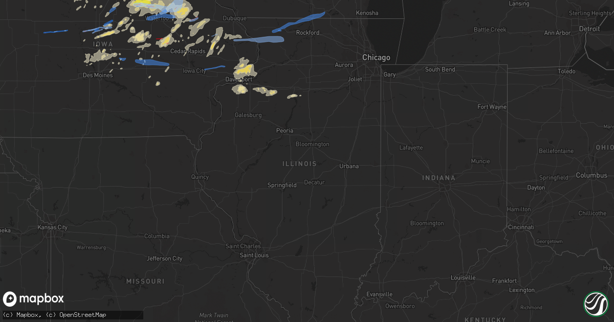
Hail Map in Illinois on July 14, 2021
Get this storm
July 14 map
$229
one time, instant access
Download today. No call, no setup
Keep the $229
Bought the map and want the full workflow? Apply the entire $229 to a subscription within 7 days. None of it is wasted.
Every map, not just this one
This buys you this map. Subscription and you get every map we run, in the markets you choose from a few cities to whole states to nationwide. Plus real-time alerts the moment a storm fires.
Contact data
Name, contact info, occupancy, even credit band for addresses in the footprint. You go from where it hit to who to call.
Become the source they trust
Unlimited branding weather history reports on demand. You already have the documented answer ready for the property owner, and you are the one who showed up with it.
Property data and RoofTrace estimates
Pull up any address you have got, its value and the exact code rules for that jurisdiction, straight from One Click Code. Then RoofTrace estimates the squares, pitch, and roof value, priced the way you price.
Storm reports in Illinois
Illinois
| Date | Description |
|---|---|
| 07/14/20211:39 AM CDT | Photo shared on social media of a large tree limb snapped in genoa. Time estimated from radar. |
| 07/14/20211:31 AM CDT | Photo shared on social media of a large tree limb downed onto the canopy of a gazebo. Time estimated from radar. |
| 07/14/20211:09 AM CDT | Tree limb down in a yard that brought down some wires. Also received a report from broadcast media of small tree limbs down in town. Time estimated from radar. |
| 07/14/202112:33 AM CDT | Several large branches and a couple of trees downed along yale bridge rd. Time estimated from radar. |
| 07/14/202112:15 AM CDT | At least one tree reported to be blown down in freeport. |
| 07/14/202112:10 AM CDT | Large tree branch reported down just outside of town. |
| 07/14/202112:00 AM CDT | Tree reported to be blown down. |
| 07/13/202111:27 PM CDT | At 427 PM CDT, a severe thunderstorm was located over Hennepin, moving east at 30 mph. HAZARD...60 mph wind gusts and quarter size hail. SOURCE...Radar indicated. IMPACT...Hail damage to vehicles is expected. Expect wind damage to roofs, siding, and trees. This severe thunderstorm will be near... DePue around 430 PM CDT. Spring Valley and Granville around 440 PM CDT. Ladd and Dalzell around 445 PM CDT. |
| 07/13/20218:15 PM CDT | At 115 PM CDT, severe thunderstorms were located along a line extending from near Blanchardville to near Winslow, moving east at 40 mph. HAZARD...60 mph wind gusts and penny size hail. SOURCE...Radar indicated. IMPACT...Expect damage to roofs, siding, and trees. Locations impacted include... Monroe, Brodhead, New Glarus, Brooklyn, Monticello, Albany, Blanchardville, Dayton, Browntown, Attica, Juda and Jordan Center. |
All States Impacted by Hail Map on July 14, 2021
Cities Impacted by Hail Map on July 14, 2021
- Wyoming, IA
- Beryl, UT
- Enterprise, UT
- Newberry, MI
- McMillan, MI
- Tooele, UT
- Souris, ND
- Allison, IA
- Dysart, IA
- Garrison, IA
- Keystone, IA
- Van Horne, IA
- Vinton, IA
- Mount Auburn, IA
- Bosler, WY
- Mechanicsville, MD
- Wetmore, MI
- Milan, IL
- Sherrard, IL
- Orion, IL
- Lynn Center, IL
- Coal Valley, IL
- Monmouth, IA
- Oxford Junction, IA
- Clarence, IA
- Cedar City, UT
- Johnson, KS
- Shellsburg, IA
- Cedar Rapids, IA
- Fairfax, IA
- Kingman, AZ
- Center Junction, IA
- Spencer, IA
- Graettinger, IA
- Dickens, IA
- Terril, IA
- Ruthven, IA
- Woden, IA
- Loganville, WI
- Chaptico, MD
- Cheyenne, WY
- Laramie, WY
- Granite Canon, WY
- Livermore, CO
- Eckerman, MI
- West Union, IA
- Elgin, IA
- Monticello, IA
- Cascade, IA
- Onslow, IA
- Radcliffe, IA
- Hubbard, IA
- Rapid City, SD
- Iola, TX
- Tonopah, NV
- Independence, IA
- Aurora, IA
- Stanley, IA
- Hazleton, IA
- Lamont, IA
- Winthrop, IA
- Welcome, MD
- La Plata, MD
- Briggsdale, CO
- Mitchellville, IA
- Carr, CO
- Rhinelander, WI
- Dallas Center, IA
- Keswick, IA
- What Cheer, IA
- Beaman, IA
- Dunkerton, IA
- Oelwein, IA
- Readlyn, IA
- Arlington, IA
- Fairbank, IA
- Oran, IA
- Fayette, IA
- Story City, IA
- Garden City, IA
- Hazelhurst, WI
- Harshaw, WI
- Springville, IA
- Central City, IA
- Anamosa, IA
- Kersey, CO
- Orchard, CO
- Green River, UT
- Huntington, UT
- Newton, IA
- Shell Rock, IA
- Clarksville, IA
- Plainfield, IA
- Waverly, IA
- Center Point, IA
- Toddville, IA
- Bettendorf, IA
- Princeton, IA
- Hillsdale, IL
- Walcott, IA
- De Witt, IA
- McCausland, IA
- Camanche, IA
- Eldridge, IA
- Long Grove, IA
- Donahue, IA
- Davenport, IA
- Le Claire, IA
- Port Byron, IL
- Cordova, IL
- Hill City, SD
- Manistique, MI
- Trinity, NC
- Geneseo, IL
- Show Low, AZ
- Maxwell, IA
- Cambridge, IA
- Ayrshire, IA
- Webb, IA
- Annawan, IL
- Sheffield, IL
- Osco, IL
- Kewanee, IL
- Atkinson, IL
- Cambridge, IL
- Neponset, IL
- Heber, AZ
- Culpeper, VA
- Jesup, IA
- Ault, CO
- Poynette, WI
- Rock Springs, WI
- North Freedom, WI
- Merrimac, WI
- Reedsburg, WI
- Hillpoint, WI
- Portage, WI
- Baraboo, WI
- Grinnell, IA
- Seligman, AZ
- Ash Fork, AZ
- East Carbon, UT
- Goldfield, IA
- Renwick, IA
- Baxter, IA
- Gladbrook, IA
- Rawlins, WY
- Newton, MS
- Millers Falls, MA
- Lake Pleasant, MA
- Belchertown, MA
- Sunderland, MA
- Amherst, MA
- Turners Falls, MA
- Wendell, MA
- Shutesbury, MA
- Northfield, MA
- Gill, MA
- Leverett, MA
- Greenfield, MA
- Montague, MA
- Erving, MA
- Nunn, CO
- Toledo, IA
- Clutier, IA
- Montour, IA
- Garwin, IA
- Alton, UT
- Grundy Center, IA
- Hampton, IA
- Alden, IA
- Iowa Falls, IA
- Fairburn, SD
- Hermosa, SD
- Saint George, UT
- Princeton, IL
- Tiskilwa, IL
- East Greenbush, NY
- Averill Park, NY
- Rensselaer, NY
- Troy, NY
- West Sand Lake, NY
- Wynantskill, NY
- Poestenkill, NY
- Ware, MA
- Deerfield, MA
- Bernardston, MA
- Granby, MA
- South Deerfield, MA
- Three Lakes, WI
- Tama, IA
- Panguitch, UT
- Marion, IA
- Tripoli, IA
- Janesville, IA
- Denver, IA
- Cedar Falls, IA
- Nevada, IA
- Ackley, IA
- Steamboat Rock, IA
- Eldora, IA
- Wellsburg, IA
- New Providence, IA
- Roland, IA
- McCallsburg, IA
- Westgate, IA
- Brandon, IA
- Sumner, IA
- Maynard, IA
- Waterloo, IA
- Aplington, IA
- Walker, IA
- Dumont, IA
- Charles City, IA
- Parkersburg, IA
- New Hartford, IA
- Strawberry Point, IA
- Bristow, IA
- Greene, IA
- Kesley, IA
- Randalia, IA
- Rowley, IA
- Dundee, IA
- Caldwell, TX
- Olin, IA
- Williams, AZ
- Conrad, IA
- Lincoln, IA
- Reinbeck, IA
- Traer, IA
- Marshalltown, IA
- Eagle Grove, IA
- Union, IA
- Louisa, VA
- Mineral, VA
- Thor, IA
- Vincent, IA
- Holland, IA
- Robins, IA
- Hiawatha, IA
- Emmetsburg, IA
- Masonville, IA
- Melrose, NY
- Schaghticoke, NY
- Mechanicville, NY
- Phillips, WI
- Colo, IA
- Albany, NY
- Watervliet, NY
- East Schodack, NY
- Cohoes, NY
- Nassau, NY
- Castleton On Hudson, NY
- Waterford, NY
- Latham, NY
- Granger, IA
- Polk City, IA
- Dyersville, IA
- Hopkinton, IA
- Ryan, IA
- Earlville, IA
- Coggon, IA
- Manchester, IA
- Delhi, IA
- Elberon, IA
- Chelsea, IA
- Keyport, NJ
- Keansburg, NJ
- Bingham Canyon, UT
- Alburnett, IA
- Overgaard, AZ
- Lakota, IA
- Collins, IA
- State Center, IA
- Rockwell, IA
- Edgewood, IA
- Stanwood, IA
- Bernard, IA
- Mechanicsville, IA
- Chatham, MI
- Hawkeye, IA
- Gowrie, IA
- Rhodes, IA
- Melbourne, IA
- Algona, IA
- Central, UT
- Glendale, UT
- Putnam, IL
- Bradford, IL
- Hennepin, IL
- Elkhart, IA
- Sheldahl, IA
- Ames, IA
- Madrid, IA
- Alleman, IA
- Slater, IA
- Huxley, IA
- Kelley, IA
- Stockton, UT
- Livermore, IA
- Hardy, IA
- Rock Island, IL
- Waukon, IA
- Decorah, IA
- Cylinder, IA
- Ludlow, MA
- Indian Head, MD
- Kinross, MI
- North Rim, AZ
- Aledo, IL
- Woodward, IA
- Lewiston, MN
- Utica, MN
- Mason City, IA
- Granville, IL
- Mark, IL
- Cobb Island, MD
- Newburg, MD
- Abell, MD
- Coltons Point, MD
- Leonardtown, MD
- Bushwood, MD
- Avenue, MD
- Mingo, IA
- Floyd, IA
- Belle Plaine, IA
- Aredale, IA
- Clarion, IA
- Galt, IA
- Albion, IA
- Taylor Ridge, IL
- Reynolds, IL
- Malcom, IA
- Britt, IA
- Gilman, IA
- Spring Grove, VA
- Columbia, VA
- Kents Store, VA
- Moline, IL
- Lake Tomahawk, WI
- Skull Valley, AZ
- Duchesne, UT
- Myton, UT
- Dows, IA
- Sophia, NC
- Waterville, IA
- Rockford, IA
- Nora Springs, IA
- Rudd, IA
- Hurricane, UT
- Marengo, IA
- Williamsburg, IA
- Laurens, IA
- Marathon, IA
- Boone, IA
- Montezuma, IA
- Leesville, SC
- Marble Rock, IA
- Maquoketa, IA
- Zwingle, IA
- La Motte, IA
- Baldwin, IA
- Bellevue, IA
- Summit, UT
- Farnhamville, IA
- Lake City, IA
- Lohrville, IA
- Ellsworth, IA
- Stratford, IA
- Jewell, IA
- Stanhope, IA
- Ionia, IA
- Lawler, IA
- New Hampton, IA
- Evansdale, IA
- Dewar, IA
- Laurel, IA
- Hartwick, IA
- Victor, IA
- Brooklyn, IA
- Ladora, IA
- Swea City, IA
- Frost, MN
- Blue Earth, MN
- Elmore, MN
- Bricelyn, MN
- Ledyard, IA
- Buffalo Center, IA
- Bradford, IA
- Bennett, IA
- New Liberty, IA
- Tipton, IA
- West Branch, IA
- Spragueville, IA
- Miles, IA
- Sabula, IA
- Andrew, IA
- Forreston, IL
- Pearl City, IL
- Mount Carroll, IL
- Shannon, IL
- Savanna, IL
- Lanark, IL
- Baileyville, IL
- Dakota, IL
- Freeport, IL
- Sharon, WI
- South Beloit, IL
- Durand, IL
- Darien, WI
- Beloit, WI
- Lena, IL
- Rock City, IL
- Davis, IL
- Clinton, WI
- Rockton, IL
- Shirland, IL
- Fredericksburg, VA


