Hail Map in Oelwein, IA on July 14, 2021
The weather event in Oelwein, IA on July 14, 2021 includes Hail, Wind, and Tornado maps. 22 states and 418 cities were impacted and suffered possible damage. The total estimated number of properties impacted is 0.
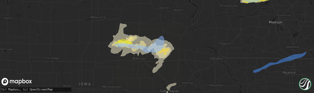
Hail
Wind
Tornado
0
Estimated number of impacted properties by a 1.00" hail or larger0
Estimated number of impacted properties by a 1.75" hail or larger0
Estimated number of impacted properties by a 2.50" hail or largerStorm reports in Oelwein, IA
Oelwein, IA
| Date | Description |
|---|---|
| 07/14/20216:50 PM CDT | Blown over corn damage along and mainly east of hwy 150 towards delaware county. Time estimated from radar. |
| 07/14/20216:40 PM CDT | Ef0 with 3 mile path length with max width of 30 yards and estimated speed of 70 mph. Mostly crop damage... But some light tree and house damage in oelwein. |
| 07/14/20216:23 PM CDT | Reports of building damage around town. |
All States Impacted by Hail Map on July 14, 2021
All Cities Impacted by Hail Map on July 14, 2021
- Wyoming, IA
- Beryl, UT
- Enterprise, UT
- Newberry, MI
- McMillan, MI
- Tooele, UT
- Souris, ND
- Allison, IA
- Dysart, IA
- Garrison, IA
- Keystone, IA
- Van Horne, IA
- Vinton, IA
- Mount Auburn, IA
- Bosler, WY
- Mechanicsville, MD
- Wetmore, MI
- Milan, IL
- Sherrard, IL
- Orion, IL
- Lynn Center, IL
- Coal Valley, IL
- Monmouth, IA
- Oxford Junction, IA
- Clarence, IA
- Cedar City, UT
- Johnson, KS
- Shellsburg, IA
- Cedar Rapids, IA
- Fairfax, IA
- Kingman, AZ
- Center Junction, IA
- Spencer, IA
- Graettinger, IA
- Dickens, IA
- Terril, IA
- Ruthven, IA
- Woden, IA
- Loganville, WI
- Chaptico, MD
- Cheyenne, WY
- Laramie, WY
- Granite Canon, WY
- Livermore, CO
- Eckerman, MI
- West Union, IA
- Elgin, IA
- Monticello, IA
- Cascade, IA
- Onslow, IA
- Radcliffe, IA
- Hubbard, IA
- Rapid City, SD
- Iola, TX
- Tonopah, NV
- Independence, IA
- Aurora, IA
- Stanley, IA
- Hazleton, IA
- Lamont, IA
- Winthrop, IA
- Welcome, MD
- La Plata, MD
- Briggsdale, CO
- Mitchellville, IA
- Carr, CO
- Rhinelander, WI
- Dallas Center, IA
- Keswick, IA
- What Cheer, IA
- Beaman, IA
- Dunkerton, IA
- Oelwein, IA
- Readlyn, IA
- Arlington, IA
- Fairbank, IA
- Oran, IA
- Fayette, IA
- Story City, IA
- Garden City, IA
- Hazelhurst, WI
- Harshaw, WI
- Springville, IA
- Central City, IA
- Anamosa, IA
- Kersey, CO
- Orchard, CO
- Green River, UT
- Huntington, UT
- Newton, IA
- Shell Rock, IA
- Clarksville, IA
- Plainfield, IA
- Waverly, IA
- Center Point, IA
- Toddville, IA
- Bettendorf, IA
- Princeton, IA
- Hillsdale, IL
- Walcott, IA
- De Witt, IA
- McCausland, IA
- Camanche, IA
- Eldridge, IA
- Long Grove, IA
- Donahue, IA
- Davenport, IA
- Le Claire, IA
- Port Byron, IL
- Cordova, IL
- Hill City, SD
- Manistique, MI
- Trinity, NC
- Geneseo, IL
- Show Low, AZ
- Maxwell, IA
- Cambridge, IA
- Ayrshire, IA
- Webb, IA
- Annawan, IL
- Sheffield, IL
- Osco, IL
- Kewanee, IL
- Atkinson, IL
- Cambridge, IL
- Neponset, IL
- Heber, AZ
- Culpeper, VA
- Jesup, IA
- Ault, CO
- Poynette, WI
- Rock Springs, WI
- North Freedom, WI
- Merrimac, WI
- Reedsburg, WI
- Hillpoint, WI
- Portage, WI
- Baraboo, WI
- Grinnell, IA
- Seligman, AZ
- Ash Fork, AZ
- East Carbon, UT
- Goldfield, IA
- Renwick, IA
- Baxter, IA
- Gladbrook, IA
- Rawlins, WY
- Newton, MS
- Millers Falls, MA
- Lake Pleasant, MA
- Belchertown, MA
- Sunderland, MA
- Amherst, MA
- Turners Falls, MA
- Wendell, MA
- Shutesbury, MA
- Northfield, MA
- Gill, MA
- Leverett, MA
- Greenfield, MA
- Montague, MA
- Erving, MA
- Nunn, CO
- Toledo, IA
- Clutier, IA
- Montour, IA
- Garwin, IA
- Alton, UT
- Grundy Center, IA
- Hampton, IA
- Alden, IA
- Iowa Falls, IA
- Fairburn, SD
- Hermosa, SD
- Saint George, UT
- Princeton, IL
- Tiskilwa, IL
- East Greenbush, NY
- Averill Park, NY
- Rensselaer, NY
- Troy, NY
- West Sand Lake, NY
- Wynantskill, NY
- Poestenkill, NY
- Ware, MA
- Deerfield, MA
- Bernardston, MA
- Granby, MA
- South Deerfield, MA
- Three Lakes, WI
- Tama, IA
- Panguitch, UT
- Marion, IA
- Tripoli, IA
- Janesville, IA
- Denver, IA
- Cedar Falls, IA
- Nevada, IA
- Ackley, IA
- Steamboat Rock, IA
- Eldora, IA
- Wellsburg, IA
- New Providence, IA
- Roland, IA
- McCallsburg, IA
- Westgate, IA
- Brandon, IA
- Sumner, IA
- Maynard, IA
- Waterloo, IA
- Aplington, IA
- Walker, IA
- Dumont, IA
- Charles City, IA
- Parkersburg, IA
- New Hartford, IA
- Strawberry Point, IA
- Bristow, IA
- Greene, IA
- Kesley, IA
- Randalia, IA
- Rowley, IA
- Dundee, IA
- Caldwell, TX
- Olin, IA
- Williams, AZ
- Conrad, IA
- Lincoln, IA
- Reinbeck, IA
- Traer, IA
- Marshalltown, IA
- Eagle Grove, IA
- Union, IA
- Louisa, VA
- Mineral, VA
- Thor, IA
- Vincent, IA
- Holland, IA
- Robins, IA
- Hiawatha, IA
- Emmetsburg, IA
- Masonville, IA
- Melrose, NY
- Schaghticoke, NY
- Mechanicville, NY
- Phillips, WI
- Colo, IA
- Albany, NY
- Watervliet, NY
- East Schodack, NY
- Cohoes, NY
- Nassau, NY
- Castleton On Hudson, NY
- Waterford, NY
- Latham, NY
- Granger, IA
- Polk City, IA
- Dyersville, IA
- Hopkinton, IA
- Ryan, IA
- Earlville, IA
- Coggon, IA
- Manchester, IA
- Delhi, IA
- Elberon, IA
- Chelsea, IA
- Keyport, NJ
- Keansburg, NJ
- Bingham Canyon, UT
- Alburnett, IA
- Overgaard, AZ
- Lakota, IA
- Collins, IA
- State Center, IA
- Rockwell, IA
- Edgewood, IA
- Stanwood, IA
- Bernard, IA
- Mechanicsville, IA
- Chatham, MI
- Hawkeye, IA
- Gowrie, IA
- Rhodes, IA
- Melbourne, IA
- Algona, IA
- Central, UT
- Glendale, UT
- Putnam, IL
- Bradford, IL
- Hennepin, IL
- Elkhart, IA
- Sheldahl, IA
- Ames, IA
- Madrid, IA
- Alleman, IA
- Slater, IA
- Huxley, IA
- Kelley, IA
- Stockton, UT
- Livermore, IA
- Hardy, IA
- Rock Island, IL
- Waukon, IA
- Decorah, IA
- Cylinder, IA
- Ludlow, MA
- Indian Head, MD
- Kinross, MI
- North Rim, AZ
- Aledo, IL
- Woodward, IA
- Lewiston, MN
- Utica, MN
- Mason City, IA
- Granville, IL
- Mark, IL
- Cobb Island, MD
- Newburg, MD
- Abell, MD
- Coltons Point, MD
- Leonardtown, MD
- Bushwood, MD
- Avenue, MD
- Mingo, IA
- Floyd, IA
- Belle Plaine, IA
- Aredale, IA
- Clarion, IA
- Galt, IA
- Albion, IA
- Taylor Ridge, IL
- Reynolds, IL
- Malcom, IA
- Britt, IA
- Gilman, IA
- Spring Grove, VA
- Columbia, VA
- Kents Store, VA
- Moline, IL
- Lake Tomahawk, WI
- Skull Valley, AZ
- Duchesne, UT
- Myton, UT
- Dows, IA
- Sophia, NC
- Waterville, IA
- Rockford, IA
- Nora Springs, IA
- Rudd, IA
- Hurricane, UT
- Marengo, IA
- Williamsburg, IA
- Laurens, IA
- Marathon, IA
- Boone, IA
- Montezuma, IA
- Leesville, SC
- Marble Rock, IA
- Maquoketa, IA
- Zwingle, IA
- La Motte, IA
- Baldwin, IA
- Bellevue, IA
- Summit, UT
- Farnhamville, IA
- Lake City, IA
- Lohrville, IA
- Ellsworth, IA
- Stratford, IA
- Jewell, IA
- Stanhope, IA
- Ionia, IA
- Lawler, IA
- New Hampton, IA
- Evansdale, IA
- Dewar, IA
- Laurel, IA
- Hartwick, IA
- Victor, IA
- Brooklyn, IA
- Ladora, IA
- Swea City, IA
- Frost, MN
- Blue Earth, MN
- Elmore, MN
- Bricelyn, MN
- Ledyard, IA
- Buffalo Center, IA
- Bradford, IA
- Bennett, IA
- New Liberty, IA
- Tipton, IA
- West Branch, IA
- Spragueville, IA
- Miles, IA
- Sabula, IA
- Andrew, IA
- Forreston, IL
- Pearl City, IL
- Mount Carroll, IL
- Shannon, IL
- Savanna, IL
- Lanark, IL
- Baileyville, IL
- Dakota, IL
- Freeport, IL
- Sharon, WI
- South Beloit, IL
- Durand, IL
- Darien, WI
- Beloit, WI
- Lena, IL
- Rock City, IL
- Davis, IL
- Clinton, WI
- Rockton, IL
- Shirland, IL
- Fredericksburg, VA


