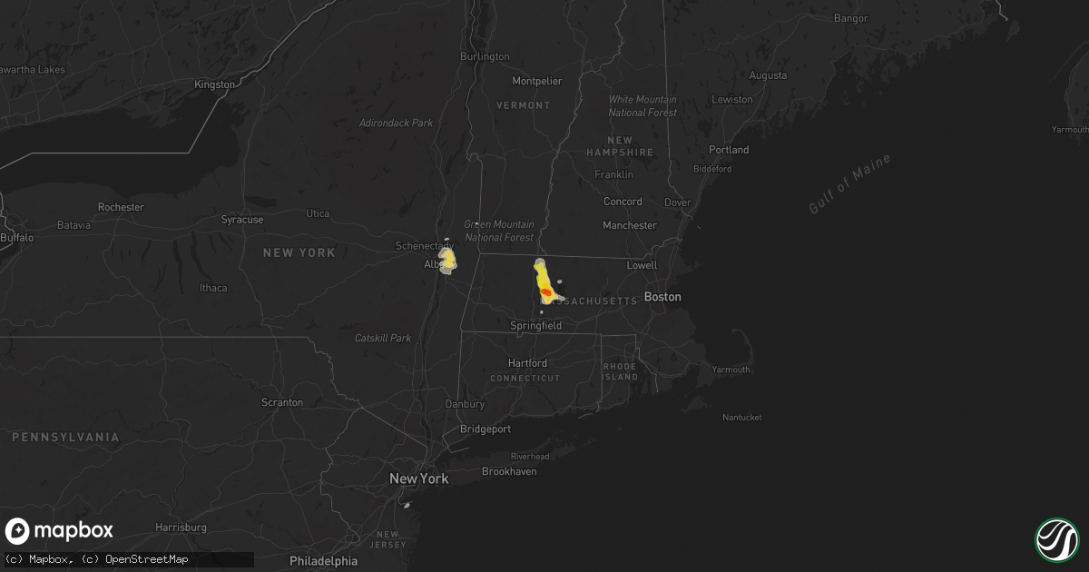
Hail Map on July 14, 2021
Get this storm
July 14 map
$229
one time, instant access
Download today. No call, no setup
Keep the $229
Bought the map and want the full workflow? Apply the entire $229 to a subscription within 7 days. None of it is wasted.
Every map, not just this one
This buys you this map. Subscription and you get every map we run, in the markets you choose from a few cities to whole states to nationwide. Plus real-time alerts the moment a storm fires.
Contact data
Name, contact info, occupancy, even credit band for addresses in the footprint. You go from where it hit to who to call.
Become the source they trust
Unlimited branding weather history reports on demand. You already have the documented answer ready for the property owner, and you are the one who showed up with it.
Property data and RoofTrace estimates
Pull up any address you have got, its value and the exact code rules for that jurisdiction, straight from One Click Code. Then RoofTrace estimates the squares, pitch, and roof value, priced the way you price.
States Impacted by Hail Map on July 14, 2021
Storm reports
North Carolina
| Date | Description |
|---|---|
| 07/14/20215:42 PM CDT | Several trees down across the northern half of the county. |
Wyoming
| Date | Description |
|---|---|
| 07/14/20214:20 PM CDT | Reports of quarter to half dollar-sized hail. |
| 07/14/20214:13 PM CDT | A local report indicates 1.75 inch wind near 8 SSE FEDERAL |
| 07/14/20214:00 PM CDT | Hail covering ground. |
| 07/14/20214:00 PM CDT | A local report indicates 1.00 inch wind near 1 SSE FEDERAL |
| 07/14/20213:51 PM CDT | Hail fell for ten minutes from 251 to 301. |
| 07/14/20213:51 AM CDT | At 851 PM MDT, a severe thunderstorm was located 9 miles southwest of Rawlins, moving east at 15 mph. HAZARD...Quarter size hail. SOURCE...Radar indicated. IMPACT...Damage to vehicles is expected. Locations impacted include... Rawlins. |
| 07/14/20211:59 AM CDT | At 659 PM MDT, a severe thunderstorm was located near Bosler, or 23 miles north of Laramie, moving northeast at 15 mph. HAZARD...Half dollar size hail. SOURCE...Radar indicated. IMPACT...Damage to vehicles is expected. Locations impacted include... Bosler. |
| 07/14/20211:34 AM CDT | At 634 PM MDT, a severe thunderstorm was located near Bosler, or 20 miles northwest of Laramie, moving northeast at 25 mph. HAZARD...Ping pong ball size hail and 60 mph wind gusts. SOURCE...Radar indicated. IMPACT...People and animals outdoors will be injured. Expect hail damage to roofs, siding, windows, and vehicles. Expect wind damage to roofs, siding, and trees. Locations impacted include... Bosler. |
| 07/14/20211:17 AM CDT | At 617 PM MDT, a severe thunderstorm was located 14 miles west of Bosler, or 22 miles northwest of Laramie, moving east at 10 mph. HAZARD...Half dollar size hail. SOURCE...Radar indicated. IMPACT...Damage to vehicles is expected. This severe thunderstorm will remain over mainly rural areas of central Albany County.This includes Interstate 80 in Wyoming between mile markers 287 and295. |
| 07/13/202110:11 PM CDT | At 311 PM MDT, a severe thunderstorm was located near Crystal Lake Reservoir, or 14 miles west of Cheyenne, moving southeast at 25 mph. HAZARD...Golf ball size hail and 60 mph wind gusts. SOURCE...Radar indicated. IMPACT...People and animals outdoors will be injured. Expect hail damage to roofs, siding, windows, and vehicles. Expect wind damage to roofs, siding, and trees. Locations impacted include... Warren AFB.This includes the following highways... Interstate 25 in Wyoming between mile markers 1 and 8. Interstate 80 in Wyoming between mile markers 344 and 359. |
| 07/13/20219:46 PM CDT | At 245 PM MDT, a severe thunderstorm was located over Federal, or 19 miles northwest of Cheyenne, moving southeast at 20 mph. HAZARD...Ping pong ball size hail and 60 mph wind gusts. SOURCE...Radar indicated. IMPACT...People and animals outdoors will be injured. Expect hail damage to roofs, siding, windows, and vehicles. Expect wind damage to roofs, siding, and trees. Locations impacted include... Cheyenne, North Cheyenne, Warren Af Base, Federal, Warren AFB and Ranchettes.This includes the following highways... Interstate 25 in Wyoming between mile markers 13 and 24. Interstate 80 in Wyoming between mile markers 349 and 356. |
| 07/13/20218:40 PM CDT | Hail sizes ranged from quarters to eggs. |
Maryland
| Date | Description |
|---|---|
| 07/14/20215:55 PM CDT | Tree down on wynn road near davis lane. |
| 07/14/20215:42 PM CDT | Wires down along charles street in solomons. |
| 07/14/20215:42 PM CDT | A local report indicates 62 MPH wind near 2 WSW PINEY POINT |
| 07/14/20215:42 PM CDT | Tree reported down on a residence on robert leon drive. |
| 07/14/20215:38 PM CDT | Tree down on michelle drive in great mills. |
| 07/14/20215:37 PM CDT | Tree and wires on the roadway near point lookout road and winters lane. |
| 07/14/20215:33 PM CDT | Numerous trees down on three notch road between first colony blvd and chancellors run road. |
| 07/14/20215:30 PM CDT | A local report indicates 58 MPH wind near 2 WSW PINEY POINT |
| 07/14/20215:28 PM CDT | Multiple trees down on fairgrounds road in the leonardtown area. |
| 07/14/20215:24 PM CDT | Tree down on woodlawn drive. |
| 07/14/20215:24 PM CDT | Tree down near the intersection of vista road and sotterly road |
| 07/14/20215:24 PM CDT | Numerous trees down in the wildewood area |
| 07/14/20215:23 PM CDT | Tree reported down on pembrook drive near clifford drive. |
| 07/14/20215:23 PM CDT | Tree reported down on potomac view drive. |
| 07/14/20215:21 PM CDT | Three trees down near the intersection of hatchet thickett road and olen mattingly road |
| 07/14/20215:19 PM CDT | Tree reported down bayside rod near bluegrass lane. |
| 07/14/20215:19 PM CDT | Tree down on hickory nut drive near poplar drive. |
| 07/14/20215:15 PM CDT | Tree down on a house on hosta way. |
| 07/14/20215:09 PM CDT | Tree reported down on colton point road near holy angels church. |
| 07/14/20215:05 PM CDT | Tree reported down on louis bailey road. |
| 07/14/20215:00 PM CDT | Tree down near colton point road and paul ellis road. |
| 07/14/20215:00 PM CDT | Tree down on bayside road. |
| 07/14/20214:55 PM CDT | Tree down along dixie lyon road near oema court. |
| 07/14/20214:51 PM CDT | Tree down along budds creek road. |
| 07/14/20214:38 PM CDT | A local report indicates 60 MPH wind near 3 ENE DAHLGREN |
| 07/14/20214:09 PM CDT | Several trees down in the la plata area. |
| 07/14/20214:04 PM CDT | Tree down onto wires near port tobacco road and mill swamp road. |
| 07/14/20213:44 PM CDT | Numerous trees down in the marbury area. |
| 07/14/20212:22 AM CDT | At 722 PM EDT, a severe thunderstorm was located 8 miles northwest of Deal Island, or 17 miles east of Saint Inigoes Creek, moving east at 25 mph. HAZARD...60 mph wind gusts and penny size hail. SOURCE...Radar indicated. IMPACT...Expect damage to trees and powerlines. This severe thunderstorm will be near, Deal Island around 740 PM EDT. Princess Anne around 810 PM EDT.Other locations impacted by this severe thunderstorm include GreenHill, Catchpenny, Wetipquin, Oriole, Trinity, Fairmount, Upper Hill,Royal Oak, Crocheron and Dames Quarter. |
| 07/14/20211:47 AM CDT | At 646 PM EDT, a severe thunderstorm was located over Kinsale, or near Callao, moving east at 30 mph. HAZARD...60 mph wind gusts and penny size hail. SOURCE...Radar indicated. IMPACT...Expect damage to trees and powerlines. This severe thunderstorm will be near, Callao around 650 PM EDT. Lewisetta around 700 PM EDT.Other locations impacted by this severe thunderstorm include Ethel,Currioman Landing, Lottsburg, Threeway, Village, Mount Holly,Oldhams, Hull Neck, Edwardsville and Lyells. |
| 07/14/20211:03 AM CDT | At 603 PM EDT, severe thunderstorms were located along a line extending from near Golden Beach to Saint Clements Bay, moving east at 25 mph. HAZARD...60 mph wind gusts. SOURCE...Radar indicated. IMPACT...Damaging winds will cause some trees and large branches to fall. This could injure those outdoors, as well as damage homes and vehicles. Roadways may become blocked by downed trees. Localized power outages are possible. Unsecured light objects may become projectiles. Locations impacted include... Lexington Park, Chesapeake Ranch Estates, Leonardtown, Piney Point, Tall Timbers, Saint Inigoes Creek, Cuckold Creek, Saint Marys City, Saint George Island, Sheridan Point, Calvert Cliffs, Greenwell State Park, Saint Leonard Creek, Saint Clements Bay, Town Creek, Saint Marys River, White Point Beach, California, Lusby and Patuxent River Naval Air Station. |
| 07/14/202112:46 AM CDT | At 546 PM EDT, a severe thunderstorm was located near Colonial Beach, moving northeast at 20 mph. HAZARD...60 mph wind gusts and quarter size hail. SOURCE...Radar indicated. IMPACT...Damaging winds will cause some trees and large branches to fall. This could injure those outdoors, as well as damage homes and vehicles. Roadways may become blocked by downed trees. Localized power outages are possible. Unsecured light objects may become projectiles. Locations impacted include... Leonardtown, Sheridan Point, Saint Clements Bay, Wicomico River, Mechanicsville, Cobb Island, Rock Point, Bushwood, Clements, Issue, Tompkinsville, Abell, Chaptico, Sandgates, Swan Point, Avenue, Loveville, Oakley, Morganza and Compton. |
| 07/14/202112:24 AM CDT | At 523 PM EDT, severe thunderstorms were located along a line extending from near Waldorf to near Port Tobacco River to Dahlgren, moving east at 25 mph. HAZARD...60 mph wind gusts and quarter size hail. SOURCE...Radar indicated. IMPACT...Damaging winds will cause some trees and large branches to fall. This could injure those outdoors, as well as damage homes and vehicles. Roadways may become blocked by downed trees. Localized power outages are possible. Unsecured light objects may become projectiles. Locations impacted include... Waldorf, La Plata, Leonardtown, Sheridan Point, Popes Creek, Hallowing Point, Golden Beach, Saint Charles, Wicomico, Huntingtown, Hughesville, Baden, Mechanicsville, Charlotte Hall, Aquasco, Bryantown, Benedict, Eagle Harbor, Bushwood and Clements. |
| 07/14/202112:14 AM CDT | At 514 PM EDT, a severe thunderstorm was located over King George, moving east at 15 mph. HAZARD...60 mph wind gusts and quarter size hail. SOURCE...Radar indicated. IMPACT...Damaging winds will cause some trees and large branches to fall. This could injure those outdoors, as well as damage homes and vehicles. Roadways may become blocked by downed trees. Localized power outages are possible. Unsecured light objects may become projectiles. Locations impacted include... King George, Dahlgren, Fairview Beach, Nanjemoy Creek, Weedonville, Ninde and Berthaville. |
| 07/14/202112:01 AM CDT | At 501 PM EDT, severe thunderstorms were located along a line extending from 6 miles southwest of Stafford to Fredericksburg to near Spotsylvania, moving east at 10 mph. HAZARD...60 mph wind gusts and quarter size hail. SOURCE...Radar indicated. IMPACT...Damaging winds will cause some trees and large branches to fall. This could injure those outdoors, as well as damage homes and vehicles. Roadways may become blocked by downed trees. Localized power outages are possible. Unsecured light objects may become projectiles. Locations impacted include... Fredericksburg, King George, Fairview Beach, Potomac Creek, Aquia Creek, Massaponax, Spotsylvania, Falmouth, Passapatanzy, Stones Corner, Leeland, Spring Valley, Brooke, Lambs Creek, White Oak, Sealston, Brookfield and Dogue. |
| 07/13/202111:41 PM CDT | At 441 PM EDT, a severe thunderstorm was located near Quantico, moving east at 20 mph. HAZARD...60 mph wind gusts and quarter size hail. SOURCE...Radar indicated. IMPACT...Damaging winds will cause some trees and large branches to fall. This could injure those outdoors, as well as damage homes and vehicles. Roadways may become blocked by downed trees. Localized power outages are possible. Unsecured light objects may become projectiles. Locations impacted include... Waldorf, La Plata, Port Tobacco River, Saint Charles, Wicomico, Bryans Road, Potomac Heights, Bryantown, Pomfret, Port Tobacco Village, Marbury, Dentsville, Port Tobacco, White Plains, Ironsides, Ripley, Rison, Bel Alton, Nanjemoy and Pisgah. |
Minnesota
| Date | Description |
|---|---|
| 07/14/20213:43 AM CDT | At 843 AM CDT, severe thunderstorms were located along a line extending from near Mansfield to near Clear Lake, moving northeast at 40 mph. HAZARD...60 mph wind gusts. SOURCE...Radar indicated. IMPACT...Expect damage to roofs, siding, and trees. Severe thunderstorms will be near... Emmons and Mason City Municipal Airport around 855 AM CDT.Other locations in the path of these severe thunderstorms includeMason City and Manly.This includes Interstate 35 between mile markers 194 and 218. |
| 07/14/20213:42 AM CDT | At 841 AM CDT, a severe thunderstorm was located near Mansfield, or 16 miles southwest of Albert Lea, moving northeast at 50 mph. HAZARD...60 mph wind gusts and penny size hail. SOURCE...Radar indicated. IMPACT...Expect damage to roofs, siding, and trees. This severe thunderstorm will be near... Mansfield around 845 AM CDT. Conger around 850 AM CDT. Alden around 855 AM CDT. Albert Lea and Freeborn around 900 AM CDT. |
| 07/14/20213:08 AM CDT | At 808 AM CDT, a severe thunderstorm was located 10 miles northwest of Union Slogh, or 19 miles north of Algona, moving northeast at 40 mph. HAZARD...60 mph wind gusts. SOURCE...Radar indicated. IMPACT...Expect damage to roofs, siding, and trees. This severe thunderstorm will remain over mainly rural areas of northern Kossuth and northwestern Winnebago Counties, including the following locations... Bancroft, Ledyard, Swea City, Buffalo Center, Rake and Lakota. |
Wisconsin
| Date | Description |
|---|---|
| 07/14/20215:55 PM CDT | Reports of downed trees and limbs around the poynette area. Time estimated via radar. |
| 07/14/20215:45 PM CDT | Reports of downed trees and limbs around the caledonia area in columbia county. Time estimated via radar. |
| 07/14/20215:30 PM CDT | Multiple reports of downed trees... Limbs... And powerlines across baraboo and the surrounding areas. Time estimated based on radar. |
| 07/14/20215:28 PM CDT | Report relayed via social media. Time estimated via radar. |
| 07/14/20215:25 PM CDT | *** 1 inj *** report of roof damage to a garage along with trees down on spring valley rd. Time estimated via radar. |
| 07/14/20215:22 PM CDT | Multiple trees down in north freedom. Time estimated via radar. |
| 07/14/20214:10 PM CDT | Several trees down in the northwest portion of manitowoc and points to the northwest in manitowoc county. |
| 07/14/20213:40 PM CDT | Multiple large branches down. Estimated wind 60mph. |
| 07/14/20213:38 PM CDT | A few tree limbs snapped in city. Via social media |
| 07/14/20212:40 PM CDT | Reported by sheriff deputy near highway 17 and jennie webber lake road south of sugar camp. |
| 07/14/20212:30 PM CDT | Picture relayed via social media shows a tree blown down on a parked car in janesville. Time of damage estimated from radar. |
| 07/14/20217:50 AM CDT | At 1250 PM CDT, severe thunderstorms were located along a line extending from 6 miles southeast of Belmont to near Scales Mound, moving east at 45 mph. HAZARD...60 mph wind gusts and penny size hail. SOURCE...Radar indicated. IMPACT...Expect damage to roofs, siding, and trees. Locations impacted include... Darlington, Shullsburg, Benton, Argyle, Wiota, New Diggings, South Wayne, Fayette, Lamont, Gratiot, Calamine, Lead Mine, Yellowstone Lake St Park and Woodford.People attending The Lafayette County Fair in Darlington should seeksafe shelter immediately! |
| 07/14/20216:40 AM CDT | At 1140 AM CDT, a severe thunderstorm was located near Dyersville, or 18 miles east of Manchester, moving east at 45 mph. HAZARD...60 mph wind gusts and quarter size hail. SOURCE...Radar indicated. IMPACT...Hail damage to vehicles is expected. Expect wind damage to roofs, siding, and trees. This severe thunderstorm will be near... Farley around 1145 AM CDT. Epworth and Bankston around 1150 AM CDT. Peosta around 1155 AM CDT. Dubuque and Centralia around 1200 PM CDT.Other locations in the path of this severe thunderstorm includeAsbury, Durango, Sageville and East Dubuque. |
| 07/14/20213:11 AM CDT | At 810 PM CDT, a severe thunderstorm was located over Greeley, or 8 miles northeast of Manchester, moving northeast at 45 mph. HAZARD...60 mph wind gusts and quarter size hail. SOURCE...Radar indicated. IMPACT...Hail damage to vehicles is expected. Expect wind damage to roofs, siding, and trees. This severe thunderstorm will be near... Colesburg around 820 PM CDT. Luxemburg around 830 PM CDT.Other locations in the path of this severe thunderstorm include HolyCross and Balltown. |
| 07/14/20211:28 AM CDT | Medium sized tree branches fallen around neighborhood. |
| 07/14/202112:47 AM CDT | Multiple reports of trees and power lines down in the beloit area. Time estimated from radar. |
| 07/14/202112:45 AM CDT | At 544 PM CDT, a severe thunderstorm was located over Portage, moving east at 40 mph. HAZARD...60 mph wind gusts and quarter size hail. SOURCE...Radar indicated. IMPACT...Hail damage to vehicles is expected. Expect wind damage to roofs, siding, and trees. Locations impacted include... Beaver Dam, Portage, Lake Wisconsin, Poynette, Pardeeville, Randolph, Markesan, Rio, Cambria, Fox Lake, Alto, Manchester, Wyocena, Otsego, Fairwater, Friesland, Kingston, Doylestown, Marquette and Astico.This includes the following Locations Pine Island State WildlifeArea, Historic Indian Agency House, French Creek Wildlife Area, andAlliant Energy Portage Power Plant. |
| 07/14/202112:16 AM CDT | At 516 PM CDT, a severe thunderstorm was located 8 miles southwest of West Baraboo, or 9 miles southeast of Reedsburg, moving east at 40 mph. HAZARD...60 mph wind gusts and quarter size hail. SOURCE...Radar indicated. IMPACT...Hail damage to vehicles is expected. Expect wind damage to roofs, siding, and trees. Locations impacted include... Baraboo, Portage, Reedsburg, Lake Wisconsin, Lodi, West Baraboo, Bluffview, North Freedom, Merrimac, Rock Springs, Loganville, Harmony Grove, Interstate 90/94 Interchange, Okee and Devils Lake St Park.People attending The Sauk County Fair should seek safe shelterimmediately!This includes the following Locations Gibraltar Rock Natural AreaCounty Park, Pine Island State Wildlife Area, and Historic IndianAgency House. |
| 07/13/202111:09 PM CDT | At 409 PM CDT, severe thunderstorms were located along a line extending from 6 miles northeast of Oconto to near Valders, moving east at 50 mph. HAZARD...60 mph wind gusts. SOURCE...Radar indicated. IMPACT...Expect damage to roofs, siding, and trees. Locations impacted include... Manitowoc, Sturgeon Bay, Kewaunee, Algoma, Luxemburg, Two Creeks, Two Rivers, Newton, Mishicot and Larrabee. |
New Hampshire
| Date | Description |
|---|---|
| 07/14/20214:06 PM CDT | Trained spotter reports two trees down on northbound lane of state road 10 partially blocking lane. Time estimated from radar. |
| 07/14/20214:00 PM CDT | Large tree 18 inches in diameter down with numerous branches down along hwy 63. |
| 07/14/20213:50 PM CDT | Numerous branches down on pleasant street and surrounding streets west of downtown bristol. Pea-sized hail fell for about 5 minutes. |
| 07/14/20213:00 PM CDT | Hail on us highway 4 west of canaan. Radar estimated time. |
| 07/14/20212:39 PM CDT | Tree down across alden road and 0.75 hail. Time estimated based on radar. |
| 07/14/20212:37 PM CDT | Tree down on farman ave. Time based on radar estimate. |
| 07/14/20212:37 PM CDT | Trees down at east wilder boat launch. Time estimated by radar. |
| 07/13/202111:53 PM CDT | At 452 PM EDT, a severe thunderstorm was located over Bernardston, or 8 miles north of Greenfield, moving southeast at 20 mph. HAZARD...60 mph wind gusts and penny size hail. SOURCE...Radar indicated. IMPACT...Expect damage to trees and power lines. Locations impacted include... Greenfield, Orange, Athol, Winchendon, Montague, Northfield, Bernardston, Shelburne, Erving, Phillipston, Colrain, Gill, Royalston, Petersham, New Salem, Wendell, Warwick and Leyden. |
| 07/13/202111:41 PM CDT | At 440 PM EDT, a severe thunderstorm was located 7 miles northeast of Danbury, or 11 miles south of Plymouth, moving east at 15 mph. HAZARD...60 mph wind gusts and penny size hail. SOURCE...Radar indicated. IMPACT...Expect damage to roofs, siding, and trees. Locations impacted include... Laconia, Meredith, Belmont, Bristol, Hill, Hebron, Sanbornton, New Hampton and Tilton.This includes Interstate 93 between mile markers 59 and 72. |
| 07/13/202111:32 PM CDT | At 432 PM EDT, a severe thunderstorm was located near Hinsdale, or 16 miles southwest of Keene, moving east at 35 mph. HAZARD...60 mph wind gusts and quarter size hail. SOURCE...Radar indicated. IMPACT...Hail damage to vehicles is expected. Expect wind damage to roofs, siding, and trees. Locations impacted include... Keene, Jaffrey, Swanzey, Winchester, Dublin, Richmond, Harrisville, Marlborough, Rindge, Hinsdale, Fitzwilliam, Troy, Chesterfield, Roxbury and Westmoreland.This also includes... Mount Monadnock. |
| 07/13/202111:17 PM CDT | At 417 PM EDT, a severe thunderstorm was located near Wilmington, or 10 miles west of Brattleboro, moving east at 20 mph. HAZARD...60 mph wind gusts. SOURCE...Radar indicated. IMPACT...Expect damage to roofs, siding, and trees. Locations impacted include... Brattleboro, Putney, Vernon, Wilmington, Guilford Center, Guilford, Whitingham, Dover, Marlboro, Halifax, Jacksonville, North Vernon, South Newfane, East Dummerston, East Putney, Fairview Village, Williamsville, East Dover, Four Corners and Dummerston Center. |
Utah
| Date | Description |
|---|---|
| 07/14/20216:15 PM CDT | Landspout tornado... Photos and video submitted from broadcast media. Time and location are approximate based on report and radar data. |
| 07/14/20215:45 PM CDT | Hail up to quarter size measured. Reported via social media. |
| 07/14/20212:53 AM CDT | At 753 PM MDT, severe thunderstorms were located along a line extending from 7 miles northwest of New Harmony to near Dameron Valley to 16 miles southwest of Gunlock State Park, moving southeast at 25 mph. HAZARD...60 mph wind gusts. SOURCE...Radar indicated. IMPACT...Expect damage to roofs, siding, and trees. Locations impacted include... St George, Washington, Hurricane, Santa Clara, La Verkin, New Harmony, Dameron Valley, Quail Creek State Park, Sand Hollow State Park, Gunlock State Park, Ivins, Toquerville, Leeds, Virgin, Pintura, Bloomington, Pine Valley, Pinto, Gunlock and Veyo.This includes the following highways... Interstate 15 between mile markers 1 and 37. Utah Route 18 between mile markers 0 and 30. |
| 07/14/20212:34 AM CDT | At 733 PM MDT, a severe thunderstorm was located 9 miles east of Canyonlands National Park, or 12 miles southwest of Moab, moving southeast at 30 mph. HAZARD...70 mph wind gusts. SOURCE...Radar indicated. IMPACT...Expect considerable tree damage. Damage is likely to mobile homes, roofs, and outbuildings. This severe thunderstorm will remain over mainly rural areas of northeastern San Juan and south central Grand Counties, including the following locations... Dead Horse Point State Park and La Sal Junction.This includes the following highways... U.S. Highway 191 in Utah between mile markers 96 and 121. Utah 313 between mile markers 0 and 1. |
| 07/14/20212:12 AM CDT | At 712 PM MDT, a severe thunderstorm was located 15 miles northwest of Moab, moving southeast at 35 mph. HAZARD...70 mph wind gusts. SOURCE...Radar indicated. IMPACT...Expect considerable tree damage. Damage is likely to mobile homes, roofs, and outbuildings. This severe thunderstorm will remain over mainly rural areas of southwestern Grand County.This includes the following highways... U.S. Highway 191 in Utah between mile markers 125 and 145. Utah 128 between mile markers 0 and 1. Utah 279 between mile markers 0 and 8, and between mile markers 10and 15. Utah 313 between mile markers 4 and 22. |
| 07/14/20211:25 AM CDT | At 624 PM MDT, a severe thunderstorm was located 24 miles northwest of New Harmony, or 29 miles west of Cedar City, moving southeast at 15 mph. HAZARD...60 mph wind gusts and quarter size hail. SOURCE...Radar indicated. IMPACT...Hail damage to vehicles is expected. Expect wind damage to roofs, siding, and trees. Locations impacted include... Enterprise, Pinto and Newcastle. This includes the following highways... Utah Route 18 between mile markers 34 and 51. Utah Route 56 between mile markers 17 and 48. |
| 07/14/202112:35 AM CDT | At 535 PM MDT, a severe thunderstorm was located 18 miles west of Green River, moving southeast at 25 mph. HAZARD...60 mph wind gusts and quarter size hail. SOURCE...Radar indicated. IMPACT...Hail damage to vehicles is expected. Expect wind damage to roofs, siding, and trees. This severe thunderstorm will remain over mainly rural areas of southeastern Emery County.This includes the following highways... Interstate 70 between mile markers 134 and 158. US Route 6 between mile markers 291 and 300. Utah Route 24 between mile markers 146 and 160. |
| 07/13/202111:39 PM CDT | At 438 PM MDT, a severe thunderstorm was located near Enoch, or 8 miles northeast of Cedar City, moving south at 5 mph. HAZARD...60 mph wind gusts and quarter size hail. SOURCE...Radar indicated. IMPACT...Hail damage to vehicles is expected. Expect wind damage to roofs, siding, and trees. Locations impacted include... Cedar City, Enoch, Parowan, Cedar Breaks National Monument, Summit and Brian Head.This includes the following highways... Interstate 15 between mile markers 60 and 75. Utah Route 56 near mile marker 61. |
| 07/13/202111:01 PM CDT | At 401 PM MDT, a severe thunderstorm was located 27 miles northwest of Enoch, or 29 miles northwest of Cedar City, moving south at 10 mph. HAZARD...60 mph wind gusts and quarter size hail. SOURCE...Radar indicated. IMPACT...Hail damage to vehicles is expected. Expect wind damage to roofs, siding, and trees. Locations impacted include... Lund. |
| 07/13/202110:31 PM CDT | At 330 PM MDT, a severe thunderstorm was located 7 miles southeast of Escalante, and is nearly stationary. HAZARD...Quarter size hail. SOURCE...Radar indicated. IMPACT...Damage to vehicles is expected. This severe thunderstorm will remain over mainly rural areas of south central Garfield County.This includes Utah Route 12 between mile markers 62 and 75. |
| 07/13/20219:56 PM CDT | Power lines down in washington |
| 07/13/20219:38 PM CDT | Skylights blown off roof. Heavy rain falling into home. |
| 07/13/20219:24 PM CDT | Power lines down and power out in town. Trees down on lava flow street. |
| 07/13/20219:13 PM CDT | Corrects previous tstm wnd dmg report from 16 nw moab. 5 to 6 power lines were broken off just south of the canyonlands airport near blue hills rd. This was reported to |
| 07/13/20219:03 PM CDT | Power lines down in veyo |
| 07/13/20218:25 PM CDT | Brimstone reservoir raws site. |
| 07/13/20218:11 PM CDT | Asos station kcny 16 nw moab. |
New Jersey
| Date | Description |
|---|---|
| 07/14/20216:26 PM CDT | Downed power lines near a residence on park avenue. Time estimated from radar. |
| 07/14/20216:24 PM CDT | Downed wires near hazlet avenue and route 35. Time estimated from radar. |
| 07/14/20216:04 PM CDT | Wires down near route 35. Power outages in the area. Time estimated from radar. |
| 07/14/20213:00 PM CDT | Reports of wires down. |
| 07/14/20212:55 PM CDT | Downed trees and power lines in chatham. Time estimated from radar. |
| 07/14/20212:55 PM CDT | Four utility poles were toppled on the south side of chatham. Also... A tree fell against a building. |
| 07/14/20212:24 AM CDT | At 721 PM EDT, a severe thunderstorm was located over Red Bank, or near Sandy Hook, moving east at 15 mph. This storm has produced damage with wires down down and power outages near Route 35 in Middletown Township. HAZARD...60 mph wind gusts and penny size hail. SOURCE...Law enforcement. IMPACT...Damage to roofs, siding, trees, and power lines is possible. Locations impacted include... Long Branch, Sandy Hook, Middletown, Tinton Falls, Holmdel, Red Bank, Keansburg, Matawan, Highlands, Elberon, Navesink, Collingwood Park, Lincroft, East Freehold, Eatontown, West Long Branch, Keyport, Rumson, Little Silver and Oceanport.This includes Garden State Parkway between mile markers 102 and 121. |
| 07/14/20212:03 AM CDT | At 702 PM EDT, a severe thunderstorm was located over Middletown, or 7 miles southwest of Sandy Hook, moving east at 15 mph. HAZARD...60 mph wind gusts and quarter size hail. SOURCE...Radar indicated. IMPACT...Minor damage to vehicles is possible. Wind damage to roofs, siding, trees, and power lines is possible. Locations impacted include... Long Branch, Sandy Hook, Middletown, Tinton Falls, Holmdel, Red Bank, Keansburg, Matawan, Highlands, Elberon, Navesink, Collingwood Park, Lincroft, Eatontown, West Long Branch, Keyport, Rumson, Little Silver, Oceanport and Shrewsbury.This includes Garden State Parkway between mile markers 102 and 120. |
Pennsylvania
| Date | Description |
|---|---|
| 07/14/20213:11 AM CDT | At 810 PM EDT, a severe thunderstorm was located over Berwick, moving southeast at 25 mph. HAZARD...60 mph wind gusts and quarter size hail. SOURCE...Radar indicated. IMPACT...Hail damage to vehicles is expected. Expect wind damage to roofs, siding, and trees. Locations impacted include... Berwick, Conyngham, Nescopeck, Beach Haven, East Berwick, Rock Glen, Weston, Deringer, Briggsville and Fern Glen. |
| 07/14/20213:08 AM CDT | At 807 PM EDT, a severe thunderstorm was located near Berwick, moving southeast at 30 mph. HAZARD...60 mph wind gusts. SOURCE...Radar indicated. IMPACT...Expect damage to roofs, siding, and trees. Locations impacted include... Berwick, Shenandoah, Mcadoo, Girardville, Mifflinville, Almedia, Oneida, Nuremburg, Sheppton, Brandonville, Mainville, Shumans, Shenandoah Heights, Lime Ridge, Ringtown, Briar Creek, Kelayres, Orangeville and Park Place.For those driving on Interstate 80, this includes areas between theBloomsburg-Light Street and Nescopek exits, specifically from milemarkers 238 to 247.This includes Interstate 81 from mile markers 136 to 139. |
Illinois
| Date | Description |
|---|---|
| 07/14/20211:39 AM CDT | Photo shared on social media of a large tree limb snapped in genoa. Time estimated from radar. |
| 07/14/20211:31 AM CDT | Photo shared on social media of a large tree limb downed onto the canopy of a gazebo. Time estimated from radar. |
| 07/14/20211:09 AM CDT | Tree limb down in a yard that brought down some wires. Also received a report from broadcast media of small tree limbs down in town. Time estimated from radar. |
| 07/14/202112:33 AM CDT | Several large branches and a couple of trees downed along yale bridge rd. Time estimated from radar. |
| 07/14/202112:15 AM CDT | At least one tree reported to be blown down in freeport. |
| 07/14/202112:10 AM CDT | Large tree branch reported down just outside of town. |
| 07/14/202112:00 AM CDT | Tree reported to be blown down. |
| 07/13/202111:27 PM CDT | At 427 PM CDT, a severe thunderstorm was located over Hennepin, moving east at 30 mph. HAZARD...60 mph wind gusts and quarter size hail. SOURCE...Radar indicated. IMPACT...Hail damage to vehicles is expected. Expect wind damage to roofs, siding, and trees. This severe thunderstorm will be near... DePue around 430 PM CDT. Spring Valley and Granville around 440 PM CDT. Ladd and Dalzell around 445 PM CDT. |
| 07/13/20218:15 PM CDT | At 115 PM CDT, severe thunderstorms were located along a line extending from near Blanchardville to near Winslow, moving east at 40 mph. HAZARD...60 mph wind gusts and penny size hail. SOURCE...Radar indicated. IMPACT...Expect damage to roofs, siding, and trees. Locations impacted include... Monroe, Brodhead, New Glarus, Brooklyn, Monticello, Albany, Blanchardville, Dayton, Browntown, Attica, Juda and Jordan Center. |
Virginia
| Date | Description |
|---|---|
| 07/14/20216:00 PM CDT | Trees downed along us-360. Time radar-estimated. |
| 07/14/20215:19 PM CDT | Trees down along jefferson highway. |
| 07/14/20215:00 PM CDT | Widespread tree damage south and southeast of mineral. Route 33 blocked in multiple locations by large |
| 07/14/20215:00 PM CDT | Multiple trees down south and southeast of mineral. |
| 07/14/20214:58 PM CDT | Numerous trees down between yanceyville and apple grove. |
| 07/14/20214:31 PM CDT | Several trees reported down se of the town of louisa. |
| 07/14/20214:23 PM CDT | Large tree down across james madison pkwy and davis dr |
| 07/14/20214:12 PM CDT | Wires down near tazewell st and pendleton rd |
| 07/14/20214:10 PM CDT | A local report indicates 63 MPH wind near FREDERICKSBURG |
| 07/14/20214:09 PM CDT | Tree blocking the roadway near lee drive and lansdowne road. |
| 07/14/20214:09 PM CDT | Tree in the roadway near shannon drive and lansdowne road. |
| 07/14/20214:09 PM CDT | Tree into the front of a home on bentley court. |
| 07/14/20214:06 PM CDT | Trees and wires down in 2000 block of lafayette blvd |
| 07/14/20214:04 PM CDT | Large tree down in the 5400 block of leavells crossing drive. |
| 07/14/20214:04 PM CDT | Tree and wires down on rollingwood drive near sarah lane. |
| 07/14/20214:00 PM CDT | Tree down near salem village drive and elwyn court. |
| 07/14/20213:55 PM CDT | Tree blocking the roadway in the 5900 block of harrison road. |
| 07/14/20213:49 PM CDT | Trees down near piedmont drive and chancellor park drive. |
| 07/14/20213:45 PM CDT | Tree down in 14000 block of thomas nelson hwy blocking sb lanes |
| 07/14/20213:35 PM CDT | Trees down near intersection of kellogg mill rd and bethany way |
| 07/14/20213:26 PM CDT | Tree in the roadway near garrisonville road and algrace boulevard. |
| 07/14/20213:25 PM CDT | Tree down near st adams dr and joshua rd |
| 07/14/20213:08 PM CDT | Tree down on free state road at mountjoy road. |
| 07/14/20213:08 PM CDT | Tree down at leeds manor road and crest hill road. |
| 07/14/20212:45 PM CDT | Tree down in the 3000 block of shelby road. |
| 07/14/20212:41 PM CDT | Tree down on wires on hunting shire lane... Off of henderson road. |
| 07/14/20212:36 PM CDT | Tree down along route 29 southbound at route 15. |
| 07/14/20212:36 PM CDT | Downed tree onto wires off of webster lane. |
| 07/14/20212:36 PM CDT | Wires down along on west asher street. |
| 07/14/20212:32 PM CDT | Wires down in the 400 block of james madison highway. |
| 07/14/20212:32 PM CDT | Wires down in the 2100 block of country club road. |
| 07/14/20212:13 PM CDT | Tree down along route 231 at route 670. |
| 07/14/20211:15 AM CDT | At 614 PM EDT, a severe thunderstorm was located near Gum Spring, or near Hadensville, moving northeast at 25 mph. HAZARD...60 mph wind gusts and quarter size hail. SOURCE...Radar indicated. IMPACT...Minor damage to vehicles is possible. Expect wind damage to trees and powerlines. This severe thunderstorm will be near, Montpelier around 640 PM EDT. Bumpass around 645 PM EDT.Other locations impacted by this severe thunderstorm includeChilesburg, Orchid, Beaverdam, Coatesville, Hewlett, Goodall, RutherGlen, Locust Creek, Mabelton and Apple Grove. |
| 07/14/202112:37 AM CDT | At 537 PM EDT, a severe thunderstorm was located near Mineral, moving east at 15 mph. HAZARD...60 mph wind gusts and quarter size hail. SOURCE...Radar indicated. IMPACT...Minor damage to vehicles is possible. Expect wind damage to trees and powerlines. This severe thunderstorm will be near, Mineral around 555 PM EDT. Bumpass around 615 PM EDT.Other locations impacted by this severe thunderstorm include Orchid,Pendleton, Louisa Airport, Stage Junction, Cuckoo, Caledonia,Dabneys, Yanceyville, Fredericks Hall and Tabscott. |
| 07/14/202112:12 AM CDT | At 511 PM EDT, a severe thunderstorm was located near Mineral, moving northeast at 25 mph. HAZARD...60 mph wind gusts and quarter size hail. SOURCE...Radar indicated. IMPACT...Damaging winds will cause some trees and large branches to fall. This could injure those outdoors, as well as damage homes and vehicles. Roadways may become blocked by downed trees. Localized power outages are possible. Unsecured light objects may become projectiles. Locations impacted include... Glenora, Gatewood, Logan, Partlow and Brokenburg. |
| 07/14/202112:06 AM CDT | At 506 PM EDT, a severe thunderstorm was located over Louisa, moving east at 15 mph. HAZARD...60 mph wind gusts and quarter size hail. SOURCE...Radar indicated. IMPACT...Minor damage to vehicles is possible. Expect wind damage to trees and powerlines. This severe thunderstorm will be near, Mineral around 520 PM EDT. Bumpass around 545 PM EDT.Other locations impacted by this severe thunderstorm includePendleton, Wares Crossroads, Louisa Airport and Fredericks Hall. |
| 07/13/202111:29 PM CDT | At 428 PM EDT, a severe thunderstorm was located 7 miles northwest of Schuyler, or 15 miles south of Waynesboro, moving east at 15 mph. HAZARD...60 mph wind gusts and quarter size hail. SOURCE...Radar indicated. IMPACT...Damaging winds will cause some trees and large branches to fall. This could injure those outdoors, as well as damage homes and vehicles. Roadways may become blocked by downed trees. Localized power outages are possible. Unsecured light objects may become projectiles. Locations impacted include... Schuyler, Nellysford, Scottsville, Esmont, Lovingston, Damon, North Garden, Covesville, Boyd Tavern, Woodridge, Rockfish, Greenfield, Glendower, Keene, Overton, Alberene and Faber. |
| 07/13/202111:20 PM CDT | At 420 PM EDT, severe thunderstorms were located along a line extending from 10 miles southeast of Culpeper to 6 miles northwest of Boswells Tavern, moving east at 25 mph. HAZARD...60 mph wind gusts. SOURCE...Radar indicated. IMPACT...Damaging winds will cause some trees and large branches to fall. This could injure those outdoors, as well as damage homes and vehicles. Roadways may become blocked by downed trees. Localized power outages are possible. Unsecured light objects may become projectiles. Locations impacted include... Fredericksburg, Spotsylvania, Gordonsville, Passapatanzy, Mine Run, Rhoadesville, Brokenburg, Parker, Everona, Verdiersville, Madison Run, Locust Grove, Alsop, Gold Dale, Thornhill, Nasons, Chancellorsville, Logan, Lahore and Glenora. |
| 07/13/202111:06 PM CDT | At 406 PM EDT, a severe thunderstorm was located 10 miles south of Bealeton, or 12 miles east of Culpeper, moving east at 25 mph. HAZARD...60 mph wind gusts and quarter size hail. SOURCE...Radar indicated. IMPACT...Damaging winds will cause some trees and large branches to fall. This could injure those outdoors, as well as damage homes and vehicles. Roadways may become blocked by downed trees. Localized power outages are possible. Unsecured light objects may become projectiles. Locations impacted include... Stafford, Fredericksburg, Falmouth, Leeland, Roseville, Garrisonville, Flat Run, Spring Valley, Chancellorsville, Ramoth, Heflin, Aquia, Storck, Holly Corner, Dunavant, Lake Of The Woods, Richardsville, Glendie, Morrisville and Hartwood. |
| 07/13/202111:01 PM CDT | At 401 PM EDT, severe thunderstorms were located along a line extending from near Delaplane to near Hume, moving east at 25 mph. HAZARD...60 mph wind gusts and quarter size hail. SOURCE...Radar indicated. IMPACT...Damaging winds will cause some trees and large branches to fall. This could injure those outdoors, as well as damage homes and vehicles. Roadways may become blocked by downed trees. Localized power outages are possible. Unsecured light objects may become projectiles. Locations impacted include... South Riding, Brambleton, Warrenton, Linton Hall, Haymarket, Middleburg, Arcola, The Plains, Gainesville, New Baltimore, Marshall, Nokesville, Catlett, Catharpin, Woolsey, Broken Hill, Cresthill, Meadowville, Halfway and Auburn. |
| 07/13/202110:37 PM CDT | At 337 PM EDT, a severe thunderstorm was located over Culpeper, moving east at 25 mph. HAZARD...60 mph wind gusts and quarter size hail. SOURCE...Radar indicated. IMPACT...Damaging winds will cause some trees and large branches to fall. This could injure those outdoors, as well as damage homes and vehicles. Roadways may become blocked by downed trees. Localized power outages are possible. Unsecured light objects may become projectiles. Locations impacted include... Remington, Raccoon Ford, Elkwood, Stevensburg, Brandy Station, Lois, Burr Hill, Flat Run, Winston, Lignum, Lake Of The Woods, Richardsville, Morrisville, Goldvein, Sumerduck and Mitchells. |
| 07/13/202110:26 PM CDT | At 325 PM EDT, a severe thunderstorm was located near Bull Run, or 8 miles west of Dale City, moving east at 10 mph. HAZARD...60 mph wind gusts and quarter size hail. SOURCE...Radar indicated. IMPACT...Damaging winds will cause some trees and large branches to fall. This could injure those outdoors, as well as damage homes and vehicles. Roadways may become blocked by downed trees. Localized power outages are possible. Unsecured light objects may become projectiles. Locations impacted include... Dale City, Lake Ridge, Linton Hall, Bull Run, Manassas, Sudley, Manassas Park, Fairfax Station, Gainesville, Independent Hill, Nokesville, Clifton and Aden. |
| 07/13/202110:04 PM CDT | At 304 PM EDT, a severe thunderstorm was located 8 miles west of Culpeper, moving east at 15 mph. HAZARD...60 mph wind gusts and quarter size hail. SOURCE...Radar indicated. IMPACT...Damaging winds will cause some trees and large branches to fall. This could injure those outdoors, as well as damage homes and vehicles. Roadways may become blocked by downed trees. Localized power outages are possible. Unsecured light objects may become projectiles. Locations impacted include... Culpeper, Brightwood, Raccoon Ford, Winston, Catalpa, Slate Mills, Cardova, Reva, Leon, Alanthus and Boston. |
New York
| Date | Description |
|---|---|
| 07/14/20212:43 PM CDT | Several reports of trees and wires down in the poestenkill area. Time estimated from radar. |
| 07/14/20212:21 PM CDT | Trees down blocking coila rd. |
| 07/14/20212:10 PM CDT | Several reports of trees and wires down in center brunswick. Time estimated from radar. |
| 07/13/202110:53 PM CDT | At 353 PM EDT, a severe thunderstorm was located over West Sand Lake, or near East Greenbush, moving east at 20 mph. HAZARD...60 mph wind gusts and penny size hail. SOURCE...Radar indicated. IMPACT...Expect damage to roofs, siding, and trees. Locations impacted include... East Greenbush, Rensselaer, Stephentown, Averill Park, West Sand Lake, Sand Lake, East Nassau, Totem Lodge, Garfield, North Stephentown, West Stephentown, Hoag Corners, Millers Corners, Taborton, Glass Lake, Denault Corners, Shivers Corners, Hampton Manor, Best and Luther. |
| 07/13/202110:18 PM CDT | At 318 PM EDT, a severe thunderstorm was located over Shaftsbury, or near Arlington, moving northeast at 30 mph. HAZARD...60 mph wind gusts and nickel size hail. SOURCE...Radar indicated. IMPACT...Expect damage to roofs, siding, and trees. Locations impacted include... Arlington, Londonderry, Townshend, Manchester, Stratton, Shaftsbury, Newfane, Manchester Center, West Wardsboro, Windham, White Creek, North Bennington, Dover, Jamaica, Sunderland, Wardsboro, Grafton, Peru, Glastenbury and Somerset. |
Massachusetts
| Date | Description |
|---|---|
| 07/14/20216:00 PM CDT | Tree down on wires; utility pole snapped on federal street |
| 07/14/20215:38 PM CDT | Tree down across daniel shays highway |
| 07/14/20215:30 PM CDT | Tree down across strong street |
| 07/14/20215:30 PM CDT | Golf ball size hail |
| 07/14/20215:25 PM CDT | Tree down blocking road on enfield road |
| 07/14/20215:24 PM CDT | Tree down on montague rd |
| 07/14/20215:22 PM CDT | Half dollar size hail |
| 07/14/20215:00 PM CDT | Tree and wires down on long plain road |
| 07/14/20214:55 PM CDT | Tree and wires down on east chestbut hill rd at chestbut hill loop |
| 07/14/20214:50 PM CDT | Tree and lines down on montague road and mormon hollow road |
| 07/14/20214:45 PM CDT | Tree down on munns ferry road |
| 07/14/20214:45 PM CDT | Tree and wires down on wells street and state road. |
| 07/14/20214:40 PM CDT | Quarter size hail |
| 07/14/20214:23 PM CDT | Tree down on pine meadow road near the s curves |
| 07/14/20212:46 AM CDT | At 746 PM EDT, a severe thunderstorm was located over Ludlow, or near Chicopee, moving east at 20 mph. HAZARD...60 mph wind gusts and penny size hail. SOURCE...Radar indicated. IMPACT...Expect damage to trees and power lines. Locations impacted include... Springfield, Chicopee, Ludlow, South Hadley, Southbridge, Belchertown, Wilbraham, Charlton, Palmer, Spencer, Ware, Sturbridge, Monson, Rutland, Granby, Warren, Paxton, North Brookfield, West Brookfield and Brimfield. |
| 07/14/20211:38 AM CDT | At 637 PM EDT, a severe thunderstorm was located over Pelham, or near Amherst, moving east at 15 mph. HAZARD...60 mph wind gusts and quarter size hail. SOURCE...Radar indicated. IMPACT...Expect wind damage to trees and power lines. Minor hail damage to vehicles is possible. Locations impacted include... Amherst, South Hadley, Belchertown, Palmer, Ware, Rutland, Granby, Barre, Warren, North Brookfield, Hubbardston, West Brookfield, Brookfield, Hardwick, Oakham, Shutesbury, Pelham, Petersham, New Braintree and New Salem. |
| 07/14/20211:05 AM CDT | At 605 PM EDT, a severe thunderstorm was located over Leverett, or 7 miles north of Amherst, moving southeast at 15 mph. HAZARD...60 mph wind gusts and nickel size hail. SOURCE...Radar indicated. IMPACT...Expect damage to trees and power lines. Locations impacted include... Amherst, Northampton, South Hadley, Belchertown, Palmer, Ware, Montague, Granby, Barre, Hadley, West Brookfield, Sunderland, Hatfield, Hardwick, Williamsburg, Leverett, Shutesbury, Whately, Pelham and Petersham. |
| 07/14/202112:30 AM CDT | At 530 PM EDT, a severe thunderstorm was located over Montague, or near Greenfield, moving southeast at 15 mph. HAZARD...Ping pong ball size hail and 60 mph wind gusts. SOURCE...Radar indicated. IMPACT...Expect wind damage to trees and power lines. Minor hail damage to vehicles is possible. Locations impacted include... Amherst, Greenfield, Orange, Deerfield, Belchertown, Athol, Ware, Montague, Barre, Hadley, Sunderland, Hatfield, Northfield, Hardwick, Bernardston, Conway, Leverett, Erving, Shutesbury and Phillipston. |
| 07/13/202111:15 PM CDT | At 415 PM EDT, a severe thunderstorm was located near Pownal, or near Bennington, moving east at 20 mph. HAZARD...60 mph wind gusts and nickel size hail. SOURCE...Radar indicated. IMPACT...Expect damage to roofs, siding, and trees. Locations impacted include... Berlin, Poestenkill, Barberville, Center Berlin, Petersburg, Bucks Corner, East Poestenkill, Ives Corner and Snyders Corner. |
| 07/13/202110:09 PM CDT | At 308 PM EDT, a severe thunderstorm was located over Troy, moving east at 20 mph. HAZARD...60 mph wind gusts and nickel size hail. SOURCE...Radar indicated. IMPACT...Expect damage to roofs, siding, and trees. Locations impacted include... Albany, Troy, Cohoes, Watervliet, Rensselaer, Latham, Williamstown, Menands, Pownal, Green Island, Grafton, Waterford, Berlin, Loudonville, Center Brunswick, Wyantskill, Wynantskill, North Greenbush, Brunswick and Poestenkill. |
| 07/13/20219:58 PM CDT | At 258 PM EDT, a severe thunderstorm was located near Mechanicville, moving east at 20 mph. HAZARD...60 mph wind gusts and nickel size hail. SOURCE...Radar indicated. IMPACT...Expect damage to roofs, siding, and trees. Locations impacted include... Bennington, Mechanicville, Hoosick Falls, Pownal, Grafton, Waterford, Halfmoon, Hoosick, Lee, Pittstown, White Creek, Stillwater, North Bennington, Schaghticoke, Valley Falls, Old Bennington, Schaghticoke Hill, Center White Creek, Hoosick Junction and Paper Mill Village. |
Arizona
| Date | Description |
|---|---|
| 07/13/202111:09 PM CDT | Mesonet station as887 wenden. |
| 07/13/202111:02 PM CDT | At 402 PM MST/502 PM MDT/, a severe thunderstorm was located 8 miles northwest of Marble Canyon, or 15 miles west of Page, moving southeast at 10 mph. HAZARD...60 mph wind gusts and quarter size hail. SOURCE...Radar indicated. IMPACT...Hail damage to vehicles is expected. Expect wind damage to roofs, siding, and trees. Locations impacted include... Lees Ferry and Marble Canyon. |
Colorado
| Date | Description |
|---|---|
| 07/13/20219:26 PM CDT | At 226 PM MDT, severe thunderstorms were located along a line extending from near Rifle to 11 miles west of Silt to near Parachute to 11 miles north of De Beque, moving southeast at 25 mph. HAZARD...60 mph wind gusts and penny size hail. SOURCE...Radar indicated. IMPACT...Expect damage to roofs, siding, and trees. Severe thunderstorms will be near... Rifle around 230 PM MDT. Silt around 240 PM MDT.This includes the following highways... Interstate 70 in Colorado between mile markers 68 and 97. Colorado 13 between mile markers 1 and 8. |
Michigan
| Date | Description |
|---|---|
| 07/14/20212:00 PM CDT | A microburst hit the indian river campground wednesday afternoon. Over 50 trees over a 300 yard x 200 yard area were snapped or uprooted. Maximum wind speeds were estim |
| 07/14/20212:00 PM CDT | Campground host of indian river campground reports 400-500 foot area of trees uprooted... Many 3 feet or more in diameter. The campground is inaccessible. No injuries r |
| 07/13/202110:36 PM CDT | At 335 PM EDT, a severe thunderstorm was located near Strongs, or 16 miles south of Paradise, moving east at 15 mph. HAZARD...Quarter size hail. SOURCE...Radar indicated. IMPACT...Damage to vehicles is expected. Locations impacted include... Bayview Campground, Raco, Point Iroquois, Bay Mills, Brimley, Brimley State Park, Kinross and Dafter. |
| 07/13/202110:16 PM CDT | At 316 PM EDT, a severe thunderstorm was located near Steuben, or 16 miles north of Manistique, moving east at 15 mph. HAZARD...60 mph wind gusts and quarter size hail. SOURCE...Radar indicated. IMPACT...Hail damage to vehicles is expected. Expect wind damage to roofs, siding, and trees. This severe thunderstorm will be near... M-94 between Steuben and Manistique around 325 PM EDT. |
Nevada
| Date | Description |
|---|---|
| 07/14/20211:40 AM CDT | At 639 PM PDT, a severe thunderstorm was located 19 miles southeast of Alamo, moving southeast at 15 mph. HAZARD...60 mph wind gusts. SOURCE...Radar indicated. IMPACT...Expect damage to roofs and trees. Locations impacted include... Carp and HWY 93 south of Alamo. |
| 07/13/202110:14 PM CDT | At 313 PM PDT, a severe thunderstorm was located 10 miles southeast of Duckwater, moving southeast at 15 mph. HAZARD...60 mph wind gusts and quarter size hail. SOURCE...Radar indicated. IMPACT...Hail damage to vehicles is expected. Expect wind damage to roofs, siding, and trees. Locations impacted include... Currant. |
| 07/13/20219:38 PM CDT | At 238 PM PDT, a severe thunderstorm was located over Duckwater, moving southeast at 15 mph. HAZARD...60 mph wind gusts and quarter size hail. SOURCE...Radar indicated. IMPACT...Hail damage to vehicles is expected. Expect wind damage to roofs, siding, and trees. Locations impacted include... Duckwater and Currant. |
Iowa
| Date | Description |
|---|---|
| 07/14/20216:50 PM CDT | Blown over corn damage along and mainly east of hwy 150 towards delaware county. Time estimated from radar. |
| 07/14/20216:40 PM CDT | Ef0 with 3 mile path length with max width of 30 yards and estimated speed of 70 mph. Mostly crop damage... But some light tree and house damage in oelwein. |
| 07/14/20216:40 PM CDT | Start location of oelwein tornado in buchanan county. Not a new track. |
| 07/14/20216:23 PM CDT | Reports of building damage around town. |
| 07/14/20216:22 PM CDT | Trees down. Time estimated. |
| 07/14/20216:19 PM CDT | Delayed report - brief tornado touchdown near john deere complex with some damage either side of us 218. |
| 07/14/20216:19 PM CDT | Brief tornado reported near the john deere facility with damage reported near us 218. |
| 07/14/20216:17 PM CDT | Numerous trees down. Time estimated from radar. |
| 07/14/20216:08 PM CDT | Reported at truck stop in town |
| 07/14/20216:08 PM CDT | Reported at truck stop in town. |
| 07/14/20216:06 PM CDT | Public report of tornado on ground. |
| 07/14/20216:05 PM CDT | A local report indicates a tornado near 1 NE ROCKWELL |
| 07/14/20215:56 PM CDT | A local report indicates a tornado near 4 SW FLOYD |
| 07/14/20215:51 PM CDT | A local report indicates a tornado near 1 ESE RUDD |
| 07/14/20215:40 PM CDT | A local report indicates a tornado near 2 S NORA SPRINGS |
| 07/14/20215:39 PM CDT | Tornado on the ground. Debris being lofted into the air. |
| 07/14/20215:37 PM CDT | Report via social media. |
| 07/14/20215:35 PM CDT | Tornado on the ground. Debris being lofted into the air. |
| 07/14/20215:35 PM CDT | House completely destroyed. |
| 07/14/20215:35 PM CDT | Ef0 damage along most of the path except for one farmstead |
| 07/14/20215:28 PM CDT | Significant tree damage and light structure damage. |
| 07/14/20215:25 PM CDT | Tornado reported near the intersection of 240th st and hwy 218. Tornado heading east. |
| 07/14/20215:21 PM CDT | Report via social media. Photos and videos reported. |
| 07/14/20215:20 PM CDT | Very brief skinny rope tornado. No damage seen. Report via social media. |
| 07/14/20215:19 PM CDT | Damage to trees and a home near 250th and woods ave. Report courtesy iowas news now. Time estimated by radar. |
| 07/14/20215:19 PM CDT | No damage seen yet. |
| 07/14/20215:18 PM CDT | Kgan meteorologist reports tornado near shell rock. |
| 07/14/20215:16 PM CDT | Damage begins around 250th and willow avenue. Houses damaged. Grain bins damaged. Power lines down. Damage paralleled 250th east. |
| 07/14/20215:14 PM CDT | A local report indicates 1.25 inch wind near CLARKSVILLE |
| 07/14/20215:11 PM CDT | Report from social media. |
| 07/14/20215:09 PM CDT | Confirmed tornado and damage in garden city. Time estimated from radar. |
| 07/14/20214:50 PM CDT | Tornado near the interchange of us hwy 20 and co rd r77. |
| 07/14/20214:46 PM CDT | Dnr law enforcement officer reports a tornado along 340th st. |
| 07/14/20214:40 PM CDT | Trained spotter reported a tornado still on the ground about a mile northeast of jewell. Some damage seen but unknown what was hit. Spotter confirmed it did go north of |
| 07/14/20214:37 PM CDT | Law enforcement reports a tornado at 310th st and hwy 69 north of jewell. Tornado went up briefly but touched back down and has debris. It is heading east. |
| 07/14/20214:33 PM CDT | Reported by sheriffs office. Tornado was heading east. |
| 07/14/20214:33 PM CDT | Debris reported tornado near highway 69. |
| 07/14/20214:30 PM CDT | Tornado reported west of jewell. |
| 07/14/20214:25 PM CDT | Rope tornado just touched down again. |
| 07/14/20214:23 PM CDT | A local report indicates a tornado near 2 SW WAVERLY |
| 07/14/20214:23 PM CDT | Location approximate. Tornado cycled up and was on ground at the time of this report. Report relayed by ema. |
| 07/14/20214:21 PM CDT | Tornado on the ground near 330th street and kanto avenue northeast of stanhope. |
| 07/14/20214:20 PM CDT | A local report indicates a tornado near 5 W STORY CITY |
| 07/14/20214:09 PM CDT | Multi-vortex tornado. |
| 07/14/20214:06 PM CDT | Tornado touched down and then lifted. May be cycling with a further touchdown. |
| 07/14/20214:01 PM CDT | Iowa state patrol reports trees down in lake city. Time estimated. |
| 07/14/20214:01 PM CDT | Iowa state patrol reports considerable damage to a housey. Time estimated. |
| 07/14/20218:41 AM CDT | Trees on power lines. |
| 07/14/20217:35 AM CDT | At 1235 PM CDT, a severe thunderstorm was located over Galena, moving east at 40 mph. HAZARD...60 mph wind gusts and quarter size hail. SOURCE...Radar indicated. IMPACT...Hail damage to vehicles is expected. Expect wind damage to roofs, siding, and trees. This severe thunderstorm will be near... Council Hill around 1245 PM CDT. Scales Mound around 1255 PM CDT.Other locations in the path of this severe thunderstorm includeWoodbine, Schapville, Apple River, Stockton, Warren and Nora. |
| 07/14/20216:41 AM CDT | At 1141 PM CDT, severe thunderstorms were located along a line extending from near Woodbine to 6 miles southeast of Massbach to near Savanna, moving east at 45 mph. HAZARD...60 mph wind gusts. SOURCE...Radar indicated. IMPACT...Expect damage to roofs, siding, and trees. Severe thunderstorms will be near... Mount Carroll around 1150 PM CDT. Lanark, Pearl City and Chadwick around 1200 AM CDT.Other locations in the path of these severe thunderstorms includeShannon. |
| 07/14/20216:10 AM CDT | At 1110 PM CDT, severe thunderstorms were located along a line extending from near Bellevue to near Springbrook to near Nashville, moving east at 35 mph. HAZARD...60 mph wind gusts. SOURCE...Radar indicated. IMPACT...Expect damage to roofs, siding, and trees. Severe thunderstorms will be near... Bellevue and Spragueville around 1115 PM CDT. Preston, Hanover and Elizabeth around 1120 PM CDT. Green Island around 1125 PM CDT. Miles and Massbach around 1130 PM CDT.Other locations in the path of these severe thunderstorms includeCharlotte, Savanna and Sabula. |
| 07/14/20215:52 AM CDT | At 1052 PM CDT, severe thunderstorms were located along a line extending from near Oxford Junction to Bennett to near Wilton, moving east at 45 mph. HAZARD...60 mph wind gusts. SOURCE...Radar indicated. IMPACT...Expect damage to roofs, siding, and trees. Severe thunderstorms will be near... Wheatland, Lost Nation and Toronto around 1100 PM CDT. Calamus around 1105 PM CDT. Grand Mound and Donahue around 1110 PM CDT.Other locations in the path of these severe thunderstorms includeWalcott, Delmar, Welton, Eldridge, DeWitt, Long Grove, Charlotte,McCausland, Davenport and Low Moor. |
| 07/14/20215:41 AM CDT | At 1041 PM CDT, a severe thunderstorm was located near Canton, or 12 miles northwest of Maquoketa, moving east at 30 mph. HAZARD...60 mph wind gusts. SOURCE...Radar indicated. IMPACT...Expect damage to roofs, siding, and trees. This severe thunderstorm will be near... Zwingle and Fulton around 1055 PM CDT.Other locations in the path of this severe thunderstorm includeAndrew, La Motte, Springbrook and Bellevue. |
| 07/14/20215:14 AM CDT | At 1013 PM CDT, severe thunderstorms were located along a line extending from near Bertram to near Iowa City, moving east at 40 mph. HAZARD...60 mph wind gusts. SOURCE...Radar indicated. IMPACT...Expect damage to roofs, siding, and trees. Severe thunderstorms will be near... West Branch, Mount Vernon, Lisbon and Martelle around 1025 PM CDT.Other locations in the path of these severe thunderstorms includeMechanicsville, Morley, Tipton, Olin, Rochester, Stanwood, Bennettand Durant. |
| 07/14/20214:08 AM CDT | At 907 PM CDT, a severe thunderstorm was located 7 miles north of Brooklyn, or 12 miles southeast of Toledo, moving east at 40 mph. HAZARD...60 mph wind gusts. SOURCE...Radar indicated. IMPACT...Expect damage to roofs, siding, and trees. This severe thunderstorm will be near... Belle Plaine and Victor around 920 PM CDT.Other locations in the path of this severe thunderstorm includeLadora, Luzerne, Blairstown, Marengo, Williamsburg, Conroy, Walfordand Amana. |
| 07/14/20214:06 AM CDT | At 905 AM CDT, severe thunderstorms were located along a line extending from near Mason City to 6 miles west of Allison to near Aplington, moving northeast at 40 mph. HAZARD...60 mph wind gusts. SOURCE...Radar indicated. IMPACT...Expect damage to roofs, siding, and trees. Severe thunderstorms will be near... Rudd around 925 AM CDT. Nashua around 940 AM CDT.Other locations impacted by these severe thunderstorms include CountyRoads B 60 And T 18, Howards Wood Recreational Area, Idlewilde StatePark, Roseville, Howardville, County Roads B 20 And T 26 and Oakwood.People attending the Floyd County Fairgrounds should seek safeshelter immediately! |
| 07/14/20213:49 AM CDT | At 848 AM CDT, severe thunderstorms were located along a line extending from 6 miles southeast of Iowa Falls to 6 miles northeast of Baxter, moving east at 25 mph. HAZARD...60 mph wind gusts. SOURCE...Radar indicated. At 841 AM emergency management also reported trees down on power lines in Nevada. IMPACT...Expect damage to roofs, siding, and trees. Severe thunderstorms will be near... Eldora around 855 AM CDT.Other locations in the path of these severe thunderstorms includeMeskwaki Casino, Toledo and Tama. |
| 07/14/20213:45 AM CDT | At 844 PM CDT, a severe thunderstorm was located 8 miles north of Grinnell, moving east at 30 mph. HAZARD...60 mph wind gusts. SOURCE...Radar indicated. IMPACT...Expect damage to roofs, siding, and trees. Locations impacted include... Grinnell, Toledo, Tama, Brooklyn, Meskwaki Casino, Le Grand, Victor, Holiday Lake, Malcom, Chelsea, Montour, Elberon, Hartwick, Vining, Grinnell Regional Airport and Toledo Municipal Airport.This includes Interstate 80 between mile markers 193 and 204. |
| 07/14/20213:42 AM CDT | At 841 PM CDT, severe thunderstorms were located along a line extending from 10 miles south of Nevada to 6 miles south of Marshalltown, moving east at 40 mph. HAZARD...60 mph wind gusts and penny size hail. SOURCE...Radar indicated. IMPACT...Expect damage to roofs, siding, and trees. Locations impacted include... Ames, Ankeny, Marshalltown, Newton, Altoona, Nevada, Bondurant, Huxley, Saylorville, Mitchellville, Colfax, State Center, Baxter, Rock Creek Lake, Adventureland Amusement Park, Prairie Meadows, Le Grand, Maxwell, Colo and Melbourne.This includes the following highways... Interstate 35 between mile markers 88 and 111. Interstate 80 between mile markers 141 and 163. |
| 07/14/20213:39 AM CDT | At 838 AM CDT, severe thunderstorms were located along a line extending from 9 miles south of Clear Lake to near Iowa Falls, moving east at 25 mph. HAZARD...60 mph wind gusts and nickel size hail. SOURCE...Radar indicated. IMPACT...Expect damage to roofs, siding, and trees. Locations impacted include... Ackley, Rockwell, Aplington and Parkersburg.This includes Interstate 35 between mile markers 154 and 194. |
| 07/14/20213:14 AM CDT | At 814 PM CDT, severe thunderstorms were located along a line extending from near Urbana to near Newhall, moving east at 30 mph. HAZARD...60 mph wind gusts. SOURCE...Radar indicated. IMPACT...Expect damage to roofs, siding, and trees. Severe thunderstorms will be near... Center Point around 820 PM CDT.Other locations in the path of these severe thunderstorms includePalo, Alburnett, Cedar Rapids, Paris, Central City, Toddville,Hiawatha, Robins and Marion. |
| 07/14/20213:11 AM CDT | At 811 AM CDT, a severe thunderstorm was located 8 miles southwest of Elmore, or 17 miles southeast of Fairmont, moving northeast at 50 mph. HAZARD...60 mph wind gusts and penny size hail. SOURCE...Radar indicated. IMPACT...Expect damage to roofs, siding, and trees. This severe thunderstorm will be near... Elmore around 820 AM CDT. Blue Earth and Frost around 825 AM CDT.Other locations in the path of this severe thunderstorm includeEaston, Delavan, Wells and Minnesota Lake. |
| 07/14/20212:40 AM CDT | At 739 PM CDT, a severe thunderstorm was located over Masonville, or 8 miles west of Manchester, moving east at 25 mph. HAZARD...60 mph wind gusts and quarter size hail. SOURCE...Radar indicated. IMPACT...Hail damage to vehicles is expected. Expect wind damage to roofs, siding, and trees. Locations impacted include... Manchester, Earlville, Delhi, Greeley, Delaware and Oneida. |
| 07/14/20212:37 AM CDT | At 737 PM CDT, severe thunderstorms were located along a line extending from near Brandon to Keystone, moving east at 35 mph. HAZARD...60 mph wind gusts. SOURCE...Radar indicated. IMPACT...Expect damage to roofs, siding, and trees. Severe thunderstorms will be near... Vinton around 740 PM CDT. Urbana and Van Horne around 750 PM CDT. Center Point around 755 PM CDT.Other locations in the path of these severe thunderstorms includeNewhall, Atkins, Shellsburg and Palo. |
| 07/14/20212:29 AM CDT | At 729 PM CDT, a severe thunderstorm was located 7 miles southwest of Dysart, or 11 miles northeast of Toledo, moving east at 40 mph. HAZARD...60 mph wind gusts and penny size hail. SOURCE...Radar indicated. IMPACT...Expect damage to roofs, siding, and trees. This severe thunderstorm will be near... Dysart around 740 PM CDT. |
| 07/14/20212:23 AM CDT | At 722 PM CDT, a severe thunderstorm was located near Huxley, or 8 miles south of Nevada, moving northeast at 30 mph. HAZARD...60 mph wind gusts and quarter size hail. SOURCE...Radar indicated. IMPACT...Hail damage to vehicles is expected. Expect wind damage to roofs, siding, and trees. Locations impacted include... Nevada, Huxley, State Center, Baxter, Maxwell, Colo, Melbourne, Cambridge, Zearing, Collins, Kelley, Rhodes, Mingo, Laurel, Haverhill, Clemons and St. Anthony.This includes Interstate 35 between mile markers 102 and 111. |
| 07/14/20211:56 AM CDT | At 656 PM CDT, severe thunderstorms were located along a line extending from Stanley to near Rowley, moving east at 35 mph. HAZARD...60 mph wind gusts. SOURCE...Radar indicated. IMPACT...Expect damage to roofs, siding, and trees. Severe thunderstorms will be near... Aurora around 705 PM CDT. Quasqueton and Lamont around 710 PM CDT.Other locations in the path of these severe thunderstorms includeDundee, Manchester, Edgewood and Greeley. |
| 07/14/20211:42 AM CDT | At 642 PM CDT, a severe thunderstorm was located near Traer, or 11 miles north of Toledo, moving east at 30 mph. HAZARD...60 mph wind gusts. SOURCE...Radar indicated. IMPACT...Expect damage to roofs, siding, and trees. Locations impacted include... Traer, Dysart, Gladbrook, Garwin, Clutier, Tf Clark State Park and Union Grove State Park. |
| 07/14/20211:32 AM CDT | At 632 PM CDT, severe thunderstorms were located along a line extending from near Jesup to near Traer, moving east at 35 mph. HAZARD...60 mph wind gusts. SOURCE...Radar indicated. IMPACT...Expect damage to roofs, siding, and trees. Severe thunderstorms will be near... Jesup around 635 PM CDT. Independence around 650 PM CDT.Other locations in the path of these severe thunderstorms includeGarrison and Vinton. |
| 07/14/20211:04 AM CDT | At 603 PM CDT, severe thunderstorms were located along a line extending from 6 miles south of Sumner to near Elk Run Heights, moving east at 30 mph. HAZARD...60 mph wind gusts and quarter size hail. SOURCE...Radar indicated. IMPACT...Hail damage to vehicles is expected. Expect wind damage to roofs, siding, and trees. Severe thunderstorms will be near... Fairbank around 610 PM CDT.Other locations in the path of these severe thunderstorms includeStanley, Hazleton and Independence. |
| 07/14/202112:49 AM CDT | At 548 PM CDT, severe thunderstorms were located along a line extending from near Denver to Waterloo Municipal Airport to Hudson, moving east at 35 mph. HAZARD...60 mph wind gusts. SOURCE...Radar indicated. IMPACT...Expect damage to roofs, siding, and trees. Locations impacted include... Waterloo, Cedar Falls, Evansdale, Jesup, Hudson, Dike, Elk Run Heights, Crossroads Mall, Waterloo Municipal Airport, Uni-Dome And McLeod Center, Janesville, Washburn, Dunkerton, Raymond, Gilbertville, New Hartford and George Wyth State Park.This includes Interstate 380 between mile markers 60 and 73. |
| 07/14/202112:18 AM CDT | At 518 PM CDT, a severe thunderstorm was located 10 miles southwest of Eldora, moving east at 40 mph. HAZARD...Golf ball size hail and 60 mph wind gusts. SOURCE...Radar indicated. IMPACT...People and animals outdoors will be injured. Expect hail damage to roofs, siding, windows, and vehicles. Expect wind damage to roofs, siding, and trees. This severe thunderstorm will be near... Eldora around 535 PM CDT. |
| 07/14/202112:18 AM CDT | At 518 PM CDT, a severe thunderstorm was located 10 miles southwest of Eldora, moving east at 40 mph. HAZARD...Golf ball size hail and 60 mph wind gusts. SOURCE...Radar indicated. IMPACT...People and animals outdoors will be injured. Expect hail damage to roofs, siding, windows, and vehicles. Expect wind damage to roofs, siding, and trees. This severe thunderstorm will be near... Eldora around 535 PM CDT. |
| 07/13/202111:15 PM CDT | Law enforcement relaying a public report of 60 mph winds near springbrook. |
| 07/13/202110:56 PM CDT | Ham radio relay of estimated 60 mph wind gust just west of new liberty. |
| 07/13/202110:33 PM CDT | County official reported estimated wind gusts of up to 60 mph generally 6 miles west of the tipton area. |
| 07/13/202110:30 PM CDT | An ef-1 tornado tracked across rural jones county snapping trees and ending just south of canton. |
| 07/13/202110:30 PM CDT | A trained spotter relayed a public report of a walnut tree that snapped and landed on thre vehicles in west branch. |
| 07/13/202110:02 PM CDT | An ef-1 tornado developed southeast of monticello and tracked across rural areas east of monticello along an intermittent 8 mile path through farmland and wooded areas. |
| 07/13/20219:50 PM CDT | Damage to home and machine shed. Report relayed by em. Possible tornado. Time estimated from radar. |
| 07/13/20219:45 PM CDT | Delayed report. Long-tracked 30 foot wide swath of corn flattened across field. Possibly due to tornado. Time estimated from spotter observation and radar. |
| 07/13/20219:44 PM CDT | An ef-1 tornado touched down southwest of monticello damaging outbuildings and snapping large trees on two farmsteads. |
| 07/13/20218:52 PM CDT | Brief touchdown in a field with no visible damage. |
| 07/13/20218:50 PM CDT | Brief touchdown in a field with no visible damage. |
| 07/13/20218:50 PM CDT | Large area of flattened corn. |
| 07/13/20218:46 PM CDT | Brief tornado. Delayed report from emergency manager. |
| 07/13/20218:23 PM CDT | Large tree branches down. |
| 07/13/20217:58 PM CDT | Spotters reporting two separate tornadoes... One about to cross highway 13... North of highway 20 near manchester and the other about 3 miles west of manchester. |
| 07/13/20217:53 PM CDT | Delaware county ema relayed likely tornado damage report of a damaged convenience store and power lines down on southwest side of manchester. |
| 07/13/20217:50 PM CDT | A local report indicates a tornado near 5 S VINTON |
| 07/13/20217:36 PM CDT | Benton county ema relayed a public report of a brief tornado touch down north of 61st street between garrison and vinton. |
| 07/13/20217:24 PM CDT | Dysart fire called out for a downed transformer that started a fire. |
| 07/13/20217:20 PM CDT | Benton county ema relayed public report of a brief tornado touchdown along 18th avenue 1 mile north of garrison. |
| 07/13/20217:14 PM CDT | Delayed report. Received video of a tornado crossing into benton county. Same tornado that hit dysart. |
| 07/13/20217:10 PM CDT | Brief touchdown in a field with no visible damage. |
| 07/13/20217:05 PM CDT | Structural damage to buildings. Time estimated from radar. |
Vermont
| Date | Description |
|---|---|
| 07/14/20213:47 PM CDT | Tree down on wires. Time estimated from radar. |
| 07/14/20213:08 PM CDT | Trees down on ray hill rd. Time estimated from radar. |
| 07/14/20212:25 PM CDT | Several trees and utility lines down at multiple locations in hartford/wrj by thunderstorms winds and lightning. |
| 07/14/20212:23 PM CDT | Multiple reports of trees and wires down around shaftsbury. Time estimated from radar. |
| 07/13/202110:32 PM CDT | At 332 PM EDT, a severe thunderstorm was located over Lebanon, moving east at 30 mph. HAZARD...60 mph wind gusts and penny size hail. SOURCE...Radar indicated. IMPACT...Expect damage to roofs, siding, and trees. Locations impacted include... Lebanon, Grafton, Hanover, Enfield, Canaan, Danbury, Groton, Grantham, Hebron, Dorchester, Orange, Springfield, Plainfield and Wilmot.This includes Interstate 89 between mile markers 44 and 60. |
Cities Impacted by Hail Map on July 14, 2021
- Wyoming, IA
- Beryl, UT
- Enterprise, UT
- Newberry, MI
- McMillan, MI
- Tooele, UT
- Souris, ND
- Allison, IA
- Dysart, IA
- Garrison, IA
- Keystone, IA
- Van Horne, IA
- Vinton, IA
- Mount Auburn, IA
- Bosler, WY
- Mechanicsville, MD
- Wetmore, MI
- Milan, IL
- Sherrard, IL
- Orion, IL
- Lynn Center, IL
- Coal Valley, IL
- Monmouth, IA
- Oxford Junction, IA
- Clarence, IA
- Cedar City, UT
- Johnson, KS
- Shellsburg, IA
- Cedar Rapids, IA
- Fairfax, IA
- Kingman, AZ
- Center Junction, IA
- Spencer, IA
- Graettinger, IA
- Dickens, IA
- Terril, IA
- Ruthven, IA
- Woden, IA
- Loganville, WI
- Chaptico, MD
- Cheyenne, WY
- Laramie, WY
- Granite Canon, WY
- Livermore, CO
- Eckerman, MI
- West Union, IA
- Elgin, IA
- Monticello, IA
- Cascade, IA
- Onslow, IA
- Radcliffe, IA
- Hubbard, IA
- Rapid City, SD
- Iola, TX
- Tonopah, NV
- Independence, IA
- Aurora, IA
- Stanley, IA
- Hazleton, IA
- Lamont, IA
- Winthrop, IA
- Welcome, MD
- La Plata, MD
- Briggsdale, CO
- Mitchellville, IA
- Carr, CO
- Rhinelander, WI
- Dallas Center, IA
- Keswick, IA
- What Cheer, IA
- Beaman, IA
- Dunkerton, IA
- Oelwein, IA
- Readlyn, IA
- Arlington, IA
- Fairbank, IA
- Oran, IA
- Fayette, IA
- Story City, IA
- Garden City, IA
- Hazelhurst, WI
- Harshaw, WI
- Springville, IA
- Central City, IA
- Anamosa, IA
- Kersey, CO
- Orchard, CO
- Green River, UT
- Huntington, UT
- Newton, IA
- Shell Rock, IA
- Clarksville, IA
- Plainfield, IA
- Waverly, IA
- Center Point, IA
- Toddville, IA
- Bettendorf, IA
- Princeton, IA
- Hillsdale, IL
- Walcott, IA
- De Witt, IA
- McCausland, IA
- Camanche, IA
- Eldridge, IA
- Long Grove, IA
- Donahue, IA
- Davenport, IA
- Le Claire, IA
- Port Byron, IL
- Cordova, IL
- Hill City, SD
- Manistique, MI
- Trinity, NC
- Geneseo, IL
- Show Low, AZ
- Maxwell, IA
- Cambridge, IA
- Ayrshire, IA
- Webb, IA
- Annawan, IL
- Sheffield, IL
- Osco, IL
- Kewanee, IL
- Atkinson, IL
- Cambridge, IL
- Neponset, IL
- Heber, AZ
- Culpeper, VA
- Jesup, IA
- Ault, CO
- Poynette, WI
- Rock Springs, WI
- North Freedom, WI
- Merrimac, WI
- Reedsburg, WI
- Hillpoint, WI
- Portage, WI
- Baraboo, WI
- Grinnell, IA
- Seligman, AZ
- Ash Fork, AZ
- East Carbon, UT
- Goldfield, IA
- Renwick, IA
- Baxter, IA
- Gladbrook, IA
- Rawlins, WY
- Newton, MS
- Millers Falls, MA
- Lake Pleasant, MA
- Belchertown, MA
- Sunderland, MA
- Amherst, MA
- Turners Falls, MA
- Wendell, MA
- Shutesbury, MA
- Northfield, MA
- Gill, MA
- Leverett, MA
- Greenfield, MA
- Montague, MA
- Erving, MA
- Nunn, CO
- Toledo, IA
- Clutier, IA
- Montour, IA
- Garwin, IA
- Alton, UT
- Grundy Center, IA
- Hampton, IA
- Alden, IA
- Iowa Falls, IA
- Fairburn, SD
- Hermosa, SD
- Saint George, UT
- Princeton, IL
- Tiskilwa, IL
- East Greenbush, NY
- Averill Park, NY
- Rensselaer, NY
- Troy, NY
- West Sand Lake, NY
- Wynantskill, NY
- Poestenkill, NY
- Ware, MA
- Deerfield, MA
- Bernardston, MA
- Granby, MA
- South Deerfield, MA
- Three Lakes, WI
- Tama, IA
- Panguitch, UT
- Marion, IA
- Tripoli, IA
- Janesville, IA
- Denver, IA
- Cedar Falls, IA
- Nevada, IA
- Ackley, IA
- Steamboat Rock, IA
- Eldora, IA
- Wellsburg, IA
- New Providence, IA
- Roland, IA
- McCallsburg, IA
- Westgate, IA
- Brandon, IA
- Sumner, IA
- Maynard, IA
- Waterloo, IA
- Aplington, IA
- Walker, IA
- Dumont, IA
- Charles City, IA
- Parkersburg, IA
- New Hartford, IA
- Strawberry Point, IA
- Bristow, IA
- Greene, IA
- Kesley, IA
- Randalia, IA
- Rowley, IA
- Dundee, IA
- Caldwell, TX
- Olin, IA
- Williams, AZ
- Conrad, IA
- Lincoln, IA
- Reinbeck, IA
- Traer, IA
- Marshalltown, IA
- Eagle Grove, IA
- Union, IA
- Louisa, VA
- Mineral, VA
- Thor, IA
- Vincent, IA
- Holland, IA
- Robins, IA
- Hiawatha, IA
- Emmetsburg, IA
- Masonville, IA
- Melrose, NY
- Schaghticoke, NY
- Mechanicville, NY
- Phillips, WI
- Colo, IA
- Albany, NY
- Watervliet, NY
- East Schodack, NY
- Cohoes, NY
- Nassau, NY
- Castleton On Hudson, NY
- Waterford, NY
- Latham, NY
- Granger, IA
- Polk City, IA
- Dyersville, IA
- Hopkinton, IA
- Ryan, IA
- Earlville, IA
- Coggon, IA
- Manchester, IA
- Delhi, IA
- Elberon, IA
- Chelsea, IA
- Keyport, NJ
- Keansburg, NJ
- Bingham Canyon, UT
- Alburnett, IA
- Overgaard, AZ
- Lakota, IA
- Collins, IA
- State Center, IA
- Rockwell, IA
- Edgewood, IA
- Stanwood, IA
- Bernard, IA
- Mechanicsville, IA
- Chatham, MI
- Hawkeye, IA
- Gowrie, IA
- Rhodes, IA
- Melbourne, IA
- Algona, IA
- Central, UT
- Glendale, UT
- Putnam, IL
- Bradford, IL
- Hennepin, IL
- Elkhart, IA
- Sheldahl, IA
- Ames, IA
- Madrid, IA
- Alleman, IA
- Slater, IA
- Huxley, IA
- Kelley, IA
- Stockton, UT
- Livermore, IA
- Hardy, IA
- Rock Island, IL
- Waukon, IA
- Decorah, IA
- Cylinder, IA
- Ludlow, MA
- Indian Head, MD
- Kinross, MI
- North Rim, AZ
- Aledo, IL
- Woodward, IA
- Lewiston, MN
- Utica, MN
- Mason City, IA
- Granville, IL
- Mark, IL
- Cobb Island, MD
- Newburg, MD
- Abell, MD
- Coltons Point, MD
- Leonardtown, MD
- Bushwood, MD
- Avenue, MD
- Mingo, IA
- Floyd, IA
- Belle Plaine, IA
- Aredale, IA
- Clarion, IA
- Galt, IA
- Albion, IA
- Taylor Ridge, IL
- Reynolds, IL
- Malcom, IA
- Britt, IA
- Gilman, IA
- Spring Grove, VA
- Columbia, VA
- Kents Store, VA
- Moline, IL
- Lake Tomahawk, WI
- Skull Valley, AZ
- Duchesne, UT
- Myton, UT
- Dows, IA
- Sophia, NC
- Waterville, IA
- Rockford, IA
- Nora Springs, IA
- Rudd, IA
- Hurricane, UT
- Marengo, IA
- Williamsburg, IA
- Laurens, IA
- Marathon, IA
- Boone, IA
- Montezuma, IA
- Leesville, SC
- Marble Rock, IA
- Maquoketa, IA
- Zwingle, IA
- La Motte, IA
- Baldwin, IA
- Bellevue, IA
- Summit, UT
- Farnhamville, IA
- Lake City, IA
- Lohrville, IA
- Ellsworth, IA
- Stratford, IA
- Jewell, IA
- Stanhope, IA
- Ionia, IA
- Lawler, IA
- New Hampton, IA
- Evansdale, IA
- Dewar, IA
- Laurel, IA
- Hartwick, IA
- Victor, IA
- Brooklyn, IA
- Ladora, IA
- Swea City, IA
- Frost, MN
- Blue Earth, MN
- Elmore, MN
- Bricelyn, MN
- Ledyard, IA
- Buffalo Center, IA
- Bradford, IA
- Bennett, IA
- New Liberty, IA
- Tipton, IA
- West Branch, IA
- Spragueville, IA
- Miles, IA
- Sabula, IA
- Andrew, IA
- Forreston, IL
- Pearl City, IL
- Mount Carroll, IL
- Shannon, IL
- Savanna, IL
- Lanark, IL
- Baileyville, IL
- Dakota, IL
- Freeport, IL
- Sharon, WI
- South Beloit, IL
- Durand, IL
- Darien, WI
- Beloit, WI
- Lena, IL
- Rock City, IL
- Davis, IL
- Clinton, WI
- Rockton, IL
- Shirland, IL
- Fredericksburg, VA