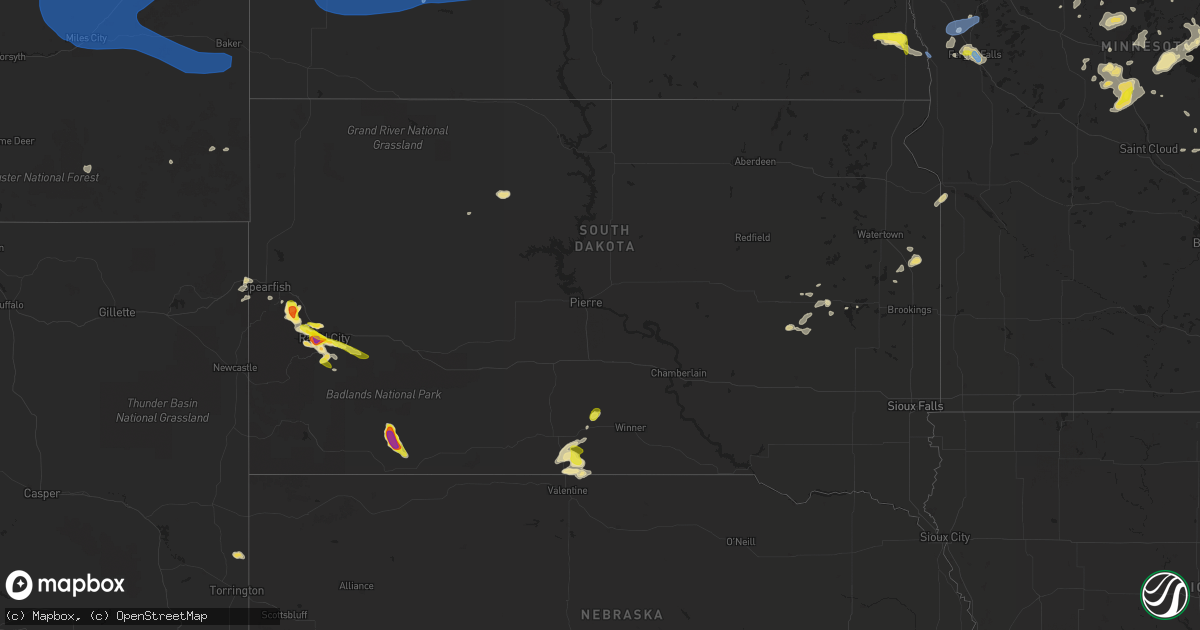
Hail Map in South Dakota on July 14, 2019
Get this storm
July 14 map
$229
one time, instant access
Download today. No call, no setup
Keep the $229
Bought the map and want the full workflow? Apply the entire $229 to a subscription within 7 days. None of it is wasted.
Every map, not just this one
This buys you this map. Subscription and you get every map we run, in the markets you choose from a few cities to whole states to nationwide. Plus real-time alerts the moment a storm fires.
Contact data
Name, contact info, occupancy, even credit band for addresses in the footprint. You go from where it hit to who to call.
Become the source they trust
Unlimited branding weather history reports on demand. You already have the documented answer ready for the property owner, and you are the one who showed up with it.
Property data and RoofTrace estimates
Pull up any address you have got, its value and the exact code rules for that jurisdiction, straight from One Click Code. Then RoofTrace estimates the squares, pitch, and roof value, priced the way you price.
Storm reports in South Dakota
South Dakota
| Date | Description |
|---|---|
| 07/14/20196:00 PM CDT | A local report indicates 1.00 inch wind near 3 ESE DWTN RAPID CITY |
| 07/14/20195:58 PM CDT | A local report indicates 60 MPH wind near 10 SSW OKREEK |
| 07/14/20195:58 PM CDT | A local report indicates 1.00 inch wind near 4 WNW RAPID CITY ARPT |
| 07/14/20194:32 PM CDT | A local report indicates 1.75 inch wind near 5 W TILFORD |
| 07/14/20193:26 PM CDT | A local report indicates 1.00 inch wind near 4 NE HAYWARD |
| 07/14/20192:45 PM CDT | A local report indicates 1.50 inch wind near 3 SW DWTN RAPID CITY |
| 07/14/20192:40 PM CDT | A local report indicates 1.25 inch wind near 2 S DWTN RAPID CITY |
| 07/14/20192:39 PM CDT | A local report indicates 1.75 inch wind near 5 WSW DWTN RAPID CITY |
| 07/14/20192:37 PM CDT | A local report indicates 1.00 inch wind near DWTN RAPID CITY |
| 07/14/20192:35 PM CDT | A local report indicates 1.50 inch wind near 1 E DOWNTOWN RAPID CITY |
| 07/14/20192:33 PM CDT | A local report indicates 1.75 inch wind near 3 WSW DWTN RAPID CITY |
| 07/14/20192:29 PM CDT | A local report indicates 2.00 inch wind near 3 WSW DWTN RAPID CITY |
| 07/14/20192:28 PM CDT | A local report indicates 1.75 inch wind near 2 WSW DWTN RAPID CITY |
| 07/14/20192:26 PM CDT | A local report indicates 1.00 inch wind near 1 NW DWTN RAPID CITY |
| 07/14/20197:53 AM CDT | At 1252 AM MDT, severe thunderstorms were located along a line extending from 7 miles southwest of Hettinger to 2 miles west of Sheep Buttes, moving east at 30 mph. HAZARD...60 mph wind gusts and nickel size hail. SOURCE...Radar indicated. At 1230 AM MDT a 59 mph wind gust was reported 8 miles northeast of Ralph. IMPACT...Expect damage to roofs, siding, and trees. Locations impacted include... Lemmon, Bison, Reva, Ralph, Lodgepole, Sorum, White Butte, Prairie City, Date, Slim Buttes, Sheep Buttes and Shadehill Reservoir. |
| 07/14/20191:55 AM CDT | At 655 PM CDT, a severe thunderstorm was located 4 miles northeast of Mosher, or 20 miles northwest of Winner, moving northeast at 25 mph. HAZARD...Quarter size hail. SOURCE...Radar indicated. IMPACT...Damage to vehicles is expected. Locations impacted include... Mosher. |
| 07/14/201912:54 AM CDT | A local report indicates 59 MPH wind near 1 N BUFFALO |
| 07/14/201912:49 AM CDT | At 549 PM MDT, a severe thunderstorm was located 5 miles northwest of Manderson, or 19 miles north of Pine Ridge, moving southeast at 20 mph. HAZARD...Ping pong ball size hail and 60 mph wind gusts. SOURCE...Radar indicated. IMPACT...People and animals outdoors will be injured. Expect hail damage to roofs, siding, windows, and vehicles. Expect wind damage to roofs, siding, and trees. Locations impacted include... Porcupine, Manderson, Wounded Knee and Sharps Corner. |
| 07/14/201912:32 AM CDT | At 532 PM CDT, a severe thunderstorm was located 7 miles southwest of Hidden Timber, or 10 miles southeast of Mission, moving northeast at 25 mph. HAZARD...60 mph wind gusts and quarter size hail. SOURCE...Radar indicated. IMPACT...Hail damage to vehicles is expected. Expect wind damage to roofs, siding, and trees. Locations impacted include... Mission, Okreek, Wood, Carter, Mosher, Hidden Timber, Clearfield, Littleburg and Haystack Butte. |
| 07/13/201911:09 PM CDT | At 409 PM MDT, a severe thunderstorm was located 4 miles north of Johnson Siding, or 11 miles west of Rapid City, moving southeast at 20 mph. HAZARD...Ping pong ball size hail. SOURCE...Radar indicated. IMPACT...People and animals outdoors will be injured. Expect damage to roofs, siding, windows, and vehicles. Hail may accumulate on roadways causing hazardous travel. Locations impacted include... Rapid City, Rapid Valley, Black Hawk, Summerset, Johnson Siding, Hisega, Hayward, Rockerville, Rapid City Airport, Bear Country, Hart Ranch, Black Gap, Reptile Gardens and Pactola Reservoir.This includes Interstate 90 in South Dakota between Mile Markers 52and 62. |
| 07/13/201910:54 PM CDT | At 354 PM MDT, a severe thunderstorm was located over Summerset, or 7 miles northwest of Rapid City, moving east at 15 mph. HAZARD...Half dollar size hail. SOURCE...Radar indicated. IMPACT...Damage to vehicles is expected. Locations impacted include... Northeastern Rapid City, northeastern Rapid Valley, Ellsworth Air Force Base, Box Elder, Black Hawk and Summerset.This includes Interstate 90 in South Dakota between Mile Markers 48and 54, and between Mile Markers 59 and 65. |
| 07/13/201910:06 PM CDT | At 306 PM MDT, a severe thunderstorm was located 5 miles northwest of Dalton Lake, or 9 miles south of Sturgis, moving north at 10 mph. HAZARD...Ping pong ball size hail. SOURCE...Radar indicated. IMPACT...People and animals outdoors will be injured. Expect damage to roofs, siding, windows, and vehicles. Locations impacted include... Sturgis, Tilford, Galena, Apple Springs, Dalton Lake and Fort Meade.This includes Interstate 90 in South Dakota between Mile Markers 31and 41. |
| 07/13/20199:29 PM CDT | At 229 AM CDT, a severe thunderstorm was located 3 miles southeast of Rosebud, or 9 miles southwest of Mission, moving east at 15 mph. HAZARD...60 mph wind gusts and quarter size hail. SOURCE...Radar indicated. IMPACT...Hail damage to vehicles is expected. Expect wind damage to roofs, siding, and trees. Locations impacted include... Rosebud, Hidden Timber, Littleburg and Lakeview. |
| 07/13/20199:19 PM CDT | At 218 PM MDT, a severe thunderstorm was located 4 miles south of Hart Ranch, or 12 miles south of Rapid City, moving southeast at 10 mph. HAZARD...60 mph wind gusts and half dollar size hail. SOURCE...Radar indicated. IMPACT...Hail damage to vehicles is expected. Expect wind damage to roofs, siding, and trees. Locations impacted include... Hermosa, Hayward, and Hart Ranch. |
| 07/13/20198:23 PM CDT | At 122 AM MDT, severe thunderstorms were located along a line extending from 4 miles east of White Butte to 9 miles south of Dears Ears Butte, moving east at 45 mph. HAZARD...60 mph wind gusts and penny size hail. SOURCE...Radar indicated. IMPACT...Expect damage to roofs, siding, and trees. Locations impacted include... Lemmon, Faith, Bison, Meadow, Chance, Lodgepole, Sorum, White Butte, Usta, Maurine, Shadehill, Opal, Castle Rock, Zeona, Hoover, Prairie City, Glad Valley, Mud Butte, Date and Owen Lake. |
| 07/13/20198:16 PM CDT | At 116 PM MDT, a severe thunderstorm was located 3 miles northeast of Hisega, or 4 miles west of Rapid City, moving southeast at 10 mph. HAZARD...Ping pong ball size hail. SOURCE...Radar indicated. IMPACT...People and animals outdoors will be injured. Expect damage to roofs, siding, windows, and vehicles. Locations impacted include... Rapid City, southern Rapid Valley, Black Hawk, Hisega, Rockerville, Rapid City Airport, Bear Country, Hart Ranch, Black Gap, and Reptile Gardens.This includes Interstate 90 in South Dakota between Mile Markers 55and 58. |
| 07/13/20197:20 PM CDT | A local report indicates 1.75 inch wind near MANDERSON |
| 07/13/20197:07 PM CDT | A local report indicates 1.75 inch wind near 3 N MANDERSON |
| 07/13/20197:00 PM CDT | A local report indicates 1.00 inch wind near 6 N CARTER |
All States Impacted by Hail Map on July 14, 2019
Cities Impacted by Hail Map on July 14, 2019
- Baldwin, ND
- Eastman, WI
- Steuben, WI
- Townsend, MT
- Little Falls, MN
- Columbus, MT
- Batavia, IL
- Isle, MN
- Ridgeville, IN
- Farmland, IN
- Winchester, IN
- New Zion, SC
- Pocatello, ID
- Mccammon, ID
- Inkom, ID
- Pine Ridge, SD
- Manderson, SD
- Alliance, NE
- Sheridan, IL
- Serena, IL
- Verona, IL
- Edinburg, ND
- Adams, ND
- Backus, MN
- Hackensack, MN
- Deadwood, SD
- Rapid City, SD
- Harrison, NE
- Crawford, NE
- Marsland, NE
- Browerville, MN
- Stockett, MT
- Elwood, IN
- Windfall, IN
- Firth, ID
- Gilman, WI
- Lublin, WI
- Thorp, WI
- Cushing, MN
- Randall, MN
- Helmville, MT
- Moore, MT
- Highwood, MT
- Dana, IN
- Whitehall, MT
- Torrington, WY
- Clear Lake, SD
- Iroquois, SD
- New Holland, IL
- Alice, TX
- Eagle Butte, SD
- Langdon, ND
- Hobson, MT
- Aitkin, MN
- Hyannis, NE
- Webster Springs, WV
- Fulton, KY
- Tucson, AZ
- Markham, TX
- Bay City, TX
- Seguin, TX
- Buffalo, MT
- Kyle, SD
- Wounded Knee, SD
- Chester, MT
- Joplin, MT
- Rudyard, MT
- Inverness, MT
- Hingham, MT
- Lake Park, MN
- Audubon, MN
- Ellsworth, NE
- Rushville, NE
- Champaign, IL
- Tolono, IL
- Savoy, IL
- Crookston, NE
- Whitman, NE
- San Jose, IL
- Delavan, IL
- Canton, IL
- Manito, IL
- Green Valley, IL
- Glasford, IL
- Emden, IL
- Mission, SD
- Cuba City, WI
- Hazel Green, WI
- Winston, MT
- Pembroke Township, IL
- White Sulphur Springs, MT
- Toston, MT
- Boulder, MT
- Hartford City, IN
- Eaton, IN
- Muncie, IN
- Cassville, WI
- Martinton, IL
- Caledonia, IL
- Loves Park, IL
- Rockford, IL
- Rockville, IN
- Montezuma, IN
- Mount Sterling, KY
- Caputa, SD
- Long Prairie, MN
- Dubuque, IA
- Otis, CO
- Akron, CO
- Big Stone City, SD
- Milbank, SD
- Bellingham, MN
- Odessa, MN
- Ramah, CO
- Sterling, IL
- Polo, IL
- Dixon, IL
- Morocco, IN
- Great Falls, MT
- Detroit Lakes, MN
- Delphi, IN
- Wood, SD
- Valentine, NE
- Box Elder, MT
- Big Sandy, MT
- Gildford, MT
- Sarles, ND
- Walker, MN
- Black Hawk, SD
- Piedmont, SD
- Swanville, MN
- Stanford, MT
- Black Canyon City, AZ
- Sheridan, WY
- Wyola, MT
- Ranchester, WY
- Parkman, WY
- Dayton, WY
- Sharpsburg, KY
- Carlisle, KY
- Hermosa, SD
- Two Dot, MT
- Nemo, SD
- Sturgis, SD
- Powell, WY
- Callaway, MN
- Cardwell, MT
- Three Forks, MT
- Luana, IA
- Monona, IA
- Richardton, ND
- Lake George, MN
- Laporte, MN
- Lavina, MT
- Roy, MT
- Estelline, SD
- Brandt, SD
- Barney, ND
- Colfax, ND
- Walcott, ND
- Joliet, MT
- Pierz, MN
- Lima, MT
- East Helena, MT
- Newark, IL
- Millington, IL
- Lindon, CO
- Cody, NE
- Brainerd, MN
- Garrison, MN
- Fergus Falls, MN
- Ponsford, MN
- Boyes, MT
- New Underwood, SD
- East Dubuque, IL
- De Smet, SD
- La Motte, IA
- Chisago City, MN
- Lindstrom, MN
- Lincoln, IL
- Bowlus, MN
- Oshkosh, NE
- Otter, MT
- Longville, MN
- Remer, MN
- Akeley, MN
- Wahpeton, ND
- Mooreton, ND
- Mcleod, ND
- Wyndmere, ND
- Avon, MT
- Munich, ND
- Rocklake, ND
- Floweree, MT
- Billings, MT
- Huntley, MT
- Hammond, MT
- Artesian, SD
- Gaston, IN
- Tipton, IN
- Camden, IN
- Marietta, OH
- Hawley, MN
- Barnesville, MN
- Sabin, MN
- Cascade, MT
- Naper, NE
- Stuart, NE
- Gardner, IL
- Dwight, IL
- Lead, SD
- Motley, MN
- Malta, ID
- Silver Star, MT
- Hilger, MT
- Absarokee, MT
- Belvidere, IL
- Forest Lake, MN
- Wyoming, MN
- Paris, KY
- Monarch, MT
- Raynesford, MT
- Belt, MT
- Geyser, MT
- Black Eagle, MT
- Milton, ND
- Livingston, MT
- Shawmut, MT
- Judith Gap, MT
- Parsons, WV
- Nisswa, MN
- Sundance, WY
- Spearfish, SD
- Beulah, WY
- Hinckley, IL
- Big Rock, IL
- Elburn, IL
- Maple Park, IL
- Beaverville, IL
- Watseka, IL
- Donovan, IL
- Fort Benton, MT
- Geraldine, MT
- Lake Preston, SD
- Lewistown, MT
- Dawson, ND
- Grass Range, MT
- Baxter, MN
- Lankin, ND
- Marion, IN
- Montpelier, IN
- Loyal, WI
- Laurel, MT
- Holy Cross, IA
- Fordville, ND
- Dalton, MN
- Wahkon, MN
- Soda Springs, ID
- Park Rapids, MN
- Pine River, MN
- Pequot Lakes, MN
- Wabash, IN
- Scandia, MN
- Sun River, MT
- Vaughn, MT
- Power, MT
- Osnabrock, ND
- Barron, WI
- Floresville, TX
- Warren, IN
- Fleming, CO
- Summitville, IN
- Clinton, IL
- Wapella, IL
- Foxhome, MN
- Pine Apple, AL
- Georgiana, AL
- Ogema, MN
- Pelican Rapids, MN
- Rothsay, MN
- Breckenridge, MN
- Fort Shaw, MT
- Peyton, CO
- Hartsburg, IL
- Princeton, MN
- Ashby, NE
- Stacy, MN
- North Branch, MN
- Greencastle, IN
- Fillmore, IN
- Mills, NE
- Staples, MN
- Emily, MN
- Stillwater, MN
- Bayport, MN
- Hudson, WI
- McLean, IL
- Decker, MT
- Yale, SD
- Cavour, SD
- Herscher, IL
- Hebron, ND
- Yorkville, IL
- Geneva, IL
- Winnett, MT
- Winner, SD
- Yuma, CO
- Ironton, MN
- Woodrow, CO
- Elkton, VA
- Ocate, NM
- Thermopolis, WY
- Sebeka, MN
- Anaconda, MT
- Sandwich, IL
- Plano, IL
- Nevis, MN
- Philo, IL
- Verndale, MN
- Osceola, WI
- Mooseheart, IL
- North Aurora, IL
- Nye, MT
- Brook, IN
- Fair Oaks, IN
- Wagon Mound, NM
- Foley, MN
- Milaca, MN
- Free Union, VA
- Rockland, ID
- Medford, WI
- Withee, WI
- Bruce, SD
- Reed Point, MT
- Pearl City, IL
- Molt, MT
- Hansboro, ND
- Sheridan, MT
- Cody, WY
- Tuttle, ND
- Menahga, MN
- Sugar Grove, IL
- Pony, MT
- Chinook, MT
- Choteau, MT
- Dutton, MT
- Bridger, MT
- Belfry, MT
- Bearcreek, MT
- Capitol, MT
- Bellevue, IA
- Wing, ND
- Deerwood, MN
- Hillman, MN
- Fort Ripley, MN
- Saint Charles, IL
- Seymour, IL
- Ivesdale, IL
- Monticello, IL
- Sherrill, IA
- Dupree, SD
- Bingham, NE
- Hemingford, NE
- Harlowton, MT
- Ledger, MT
- Conrad, MT
- Pease, MN
- Perth, ND
- McLeod, MT
- Lincoln, MT
- Heyworth, IL
- Hampshire, IL
- Van Buren, IN
- Kilgore, NE
- Aurora, IL
- Outing, MN
- Dillon, MT
- Chadron, NE
- Greenbush, ME
- Sumrall, MS
- Hattiesburg, MS
- Purvis, MS
- Lumberton, MS
- Erhard, MN
- Park City, MT
- Big Timber, MT
- Jackson, LA
- Ethel, LA
- Slaughter, LA
- Zachary, LA
- Baker, LA
- Baton Rouge, LA
- Denham Springs, LA
- Walker, LA
- Prairieville, LA
- Saint Gabriel, LA
- Greenwell Springs, LA
- Sand Springs, MT
- Forest Grove, MT
- Brusett, MT
- Mosby, MT
- Havre, MT
- Bozeman, MT
- Glasgow, MT
- Malta, MT
- Fort Peck, MT
- Nashua, MT
- Jordan, MT
- Zortman, MT
- Saint Marie, MT
- Fallon, MT
- Angela, MT
- Miles City, MT
- Rosebud, MT
- Bloomfield, MT
- Kinsey, MT
- Wibaux, MT
- Ismay, MT
- Terry, MT
- Baker, MT
- Lindsay, MT
- Willard, MT
- Cohagen, MT
- Volborg, MT
- Plevna, MT
- Glendive, MT
- Mott, ND
- Hazen, ND
- Golden Valley, ND
- New Leipzig, ND
- Lefor, ND
- Dodge, ND
- Halliday, ND
- New Salem, ND
- Medora, ND
- Glen Ullin, ND
- New England, ND
- Gladstone, ND
- Taylor, ND
- South Heart, ND
- Belfield, ND
- Dunn Center, ND
- Zap, ND
- Dickinson, ND
- Mandan, ND
- Manning, ND
- Killdeer, ND
- Amidon, ND
- Beulah, ND
- Regent, ND
- Almont, ND
- Fairfield, ND


