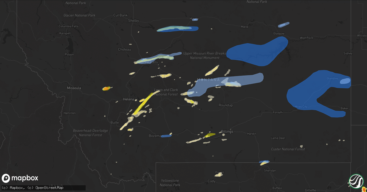
Hail Map in Montana on July 14, 2019
Get this storm
July 14 map
$229
one time, instant access
Download today. No call, no setup
Keep the $229
Bought the map and want the full workflow? Apply the entire $229 to a subscription within 7 days. None of it is wasted.
Every map, not just this one
This buys you this map. Subscription and you get every map we run, in the markets you choose from a few cities to whole states to nationwide. Plus real-time alerts the moment a storm fires.
Contact data
Name, contact info, occupancy, even credit band for addresses in the footprint. You go from where it hit to who to call.
Become the source they trust
Unlimited branding weather history reports on demand. You already have the documented answer ready for the property owner, and you are the one who showed up with it.
Property data and RoofTrace estimates
Pull up any address you have got, its value and the exact code rules for that jurisdiction, straight from One Click Code. Then RoofTrace estimates the squares, pitch, and roof value, priced the way you price.
Storm reports in Montana
Montana
| Date | Description |
|---|---|
| 07/14/20196:55 PM CDT | Asos station klwt lewistown asos. |
| 07/14/20196:45 PM CDT | A local report indicates 58 MPH wind near JUDITH GAP |
| 07/14/20196:45 PM CDT | Multiple large tree limbs down. Horse trailer was also pushed by the wind. |
| 07/14/20196:42 PM CDT | Hail covered hills to the east. |
| 07/14/20196:40 PM CDT | Hail started out at pea sized when the wind and rain started around 520 pm... But the rain became heavy by 540 pm with quarter size hail stones. |
| 07/14/20196:36 PM CDT | Awos station k1lm lima. |
| 07/14/20196:30 PM CDT | A few half-dollar sized hail stones occurred with a strong wind gust estimated to be at least 60 mph... But not measured... That blew over a horse trailer. |
| 07/14/20196:30 PM CDT | A few half-dollar sized hail stones occurred with a strong wind gust estimated to be at least 60 mph... But not measured... That blew over a horse trailer. |
| 07/14/20196:25 PM CDT | A local report indicates 58 MPH wind near 13 S INVERNESS |
| 07/14/20196:18 PM CDT | Siding blown off a shed and some limbs down on the roof of the house. Also hail damage to crops... But unable to estimate hail size as observer was not home at the time |
| 07/14/20196:17 PM CDT | Time estimated from radar. |
| 07/14/20196:13 PM CDT | Substantial crop damage from from winds and nickel size hail. |
| 07/14/20196:11 PM CDT | A local report indicates 62 MPH wind near 6 ENE LIVINGSTON |
| 07/14/20196:05 PM CDT | Report relayed via nwschat. |
| 07/14/20196:00 PM CDT | Power is out... Storm bearing down from the west. |
| 07/14/20195:40 PM CDT | A 3 to 4 inch diameter limb fell into the street. |
| 07/14/20195:39 PM CDT | Lt. Mackey called in to pass on that malmstrom weather received a report of 1 inch hail in black eagle... Mt. |
| 07/14/20195:39 PM CDT | A local report indicates 64 MPH wind near 2 W MALMSTROM AFB |
| 07/14/20195:35 PM CDT | Hail and wind damage reported on 39th ave ne... Damage to fencing... Patio furniture... And house gutters. Estimated nickle to quarter size hail with winds gusting over |
| 07/14/20195:35 PM CDT | A local report indicates 1.25 inch wind near TOWNSEND |
| 07/14/20195:35 PM CDT | A range of dime to quarter size hail dropped over the area... Gusty winds nearing 50 mph... Small branches and outdoor furniture all blown around. |
| 07/14/20195:32 PM CDT | A local report indicates 1.00 inch wind near 1 W BLACK EAGLE |
| 07/14/20195:30 PM CDT | Sherriffs office reports a tree limb down on a power line along oak street. |
| 07/14/20195:30 PM CDT | A local report indicates 59 MPH wind near 12 W LIVINGSTON |
| 07/14/20195:30 PM CDT | 61 mph wind gusts reported by the asos at nws great falls. |
| 07/14/20195:30 PM CDT | Power lines down blocking south bound lane of interstate-15 at mile marker 281.6. Hwy patrol and fire dept. On scene. Detour at vaughn frontage road. |
| 07/14/20195:27 PM CDT | Tree limbs about 3 inches in diameter are down around the sw part of town. |
| 07/14/20195:24 PM CDT | A local report indicates 83 MPH wind near 2 WNW SUN PRAIRIE |
| 07/14/20195:22 PM CDT | Ground covered with quarter size hail in the sun prairie area. |
| 07/14/20195:04 PM CDT | A local report indicates 1.50 inch wind near 4 SE HELMVILLE |
| 07/14/20196:31 AM CDT | At 1130 PM MDT, severe thunderstorms were located along a line extending from 10 miles north of Amidon to 4 miles northwest of Table Mountain, moving east at 45 mph. HAZARD...70 mph wind gusts. SOURCE...Radar indicated. IMPACT...Expect considerable tree damage. Damage is likely to mobile homes, roofs, and outbuildings. These severe thunderstorms will remain over mainly rural areas of Bowman and Slope Counties, including the following locations... Sunset Butte, Bowman Haley Dam, Griffin, Buffalo Springs, Three V Crossing, Pretty Butte and Gascoyne. |
| 07/14/20196:21 AM CDT | At 1120 PM MDT, severe thunderstorms were located along a line extending from 7 miles east of Trotters to 11 miles east of Golva, moving east at 45 mph. HAZARD...70 mph wind gusts. SOURCE...Radar indicated. IMPACT...Expect considerable tree damage. Damage is likely to mobile homes, roofs, and outbuildings. These severe thunderstorms will remain over mainly rural areas of Golden Valley, Billings and western Stark Counties, including the following locations... Alpha, Fryburg and Fairfield. |
| 07/14/20194:54 AM CDT | At 954 PM MDT, a severe thunderstorm was located 18 miles northwest of Terry, moving east at 50 mph. HAZARD...60 mph wind gusts. SOURCE...Radar indicated. IMPACT...Expect damage to roofs, siding, and trees. Locations impacted include... Glendive, Terry, Fallon, Bloomfield, West Glendive, Intake, Lindsay, Hoyt, Zero, Saint Phillip, Mccloud, Hodges, Mildred, Calypso, Forest Park, Stipek and Marsh. |
| 07/14/20194:18 AM CDT | At 918 PM MDT, a severe thunderstorm was located near St. Marie, or 17 miles northeast of Glasgow, moving east at 50 mph. HAZARD...60 mph wind gusts. SOURCE...Radar indicated. IMPACT...Expect damage to roofs, siding, and trees. Locations impacted include... Nashua, Bredette, Lustre, St. Marie, Peerless, Four Buttes, West Fork, Volt and Larslan. |
| 07/14/20193:59 AM CDT | At 859 PM MDT, a severe thunderstorm was located 15 miles northwest of White Sulphur Springs, moving northeast at 40 mph. HAZARD...70 mph wind gusts and half dollar size hail. SOURCE...Radar indicated. IMPACT...Hail damage to vehicles is expected. Expect considerable tree damage. Wind damage is also likely to mobile homes, roofs, and outbuildings. Locations impacted include... Neihart, Fort Logan On The Smith River and Fort Logan. |
| 07/14/20193:28 AM CDT | At 828 PM MDT, severe thunderstorms were located along a line extending from 18 miles east of East Helena to 8 miles east of Townsend, moving northeast at 35 mph. HAZARD...70 mph wind gusts and ping pong ball size hail. SOURCE...Radar indicated. IMPACT...People and animals outdoors will be injured. Expect hail damage to roofs, siding, windows, and vehicles. Expect considerable tree damage. Wind damage is also likely to mobile homes, roofs, and outbuildings. Locations impacted include... White Sulphur Springs, Fort Logan On The Smith River, Fort Logan and Goose Bay. |
| 07/14/20193:24 AM CDT | At 823 PM MDT, severe thunderstorms were located along a line extending from 21 miles northeast of Devils Creek Rec Area to 8 miles east of Brusett to 18 miles southeast of Edwards, moving east at 55 mph. HAZARD...70 mph wind gusts and penny size hail. SOURCE...Trained weather spotters. IMPACT...Expect considerable tree damage. Damage is likely to mobile homes, roofs, and outbuildings. Locations impacted include... Circle, Jordan, Fort Peck, The Pines Rec Area, Duck Creek Rec Area, Brockway, Hillside, Fort Peck Marina, Hell Creek Rec Area, Frazer, Flowing Wells Rest Area, Cohagen, Nelson Creek Rec Area, Rock Creek Rec Area, Oswego, Park Grove, Van Norman, Haxby, Weldon and Crow Rock. |
| 07/14/20193:00 AM CDT | Hail persisted for about 10 minutes until 210 am. |
| 07/14/20192:53 AM CDT | At 752 PM MDT, a severe thunderstorm was located 12 miles southwest of Townsend, moving northeast at 35 mph. HAZARD...60 mph wind gusts and quarter size hail. SOURCE...Radar indicated. IMPACT...Hail damage to vehicles is expected. Expect wind damage to roofs, siding, and trees. Locations impacted include... Townsend, Silos, Winston, Radersburg and Goose Bay. |
| 07/14/20192:28 AM CDT | At 728 PM MDT, severe thunderstorms were located along a line extending from 13 miles southeast of Zortman to near Crooked Creek Rec Area to 12 miles east of Flatwillow, moving east at 40 mph. HAZARD...60 mph wind gusts and penny size hail. SOURCE...Radar indicated. IMPACT...Expect damage to roofs, siding, and trees. Locations impacted include... Jordan, Sand Springs, Fourchette, Devils Creek Rec Area, Hell Creek Rec Area, Edwards, Mosby, Brusett, Content, Sun Prairie and Steve Fork. |
| 07/14/20192:11 AM CDT | At 710 PM MDT, a severe thunderstorm was located near Lockwood, or 8 miles northeast of Billings, moving east at 40 mph. HAZARD...60 mph wind gusts and half dollar size hail. SOURCE...Radar indicated. IMPACT...Hail damage to vehicles is expected. Expect wind damage to roofs, siding, and trees. This severe thunderstorm will be near... Huntley around 715 PM MDT. Ballantine and Worden around 730 PM MDT. Custer around 815 PM MDT.Other locations impacted by this severe thunderstorm include PompeysPillar.This warning does not include the city of Billings.This replaces the warning previously in effect for this area. |
| 07/14/20192:10 AM CDT | At 709 PM MDT, a severe thunderstorm was located near Ranchester, or 15 miles northwest of Sheridan, moving northeast at 25 mph. HAZARD...60 mph wind gusts and quarter size hail. SOURCE...Radar indicated. IMPACT...Hail damage to vehicles is expected. Expect wind damage to roofs, siding, and trees. Locations impacted include... Ranchester and Tongue River Reservoir. |
| 07/14/20191:54 AM CDT | A local report indicates 1.25 inch wind near 10 W BROADUS |
| 07/14/20191:30 AM CDT | At 627 PM MDT, severe thunderstorms were located along a line extending from 20 miles southwest of Zortman to 18 miles east of Roy to 15 miles southwest of Flatwillow, moving east at 50 mph. HAZARD...60 mph wind gusts and quarter size hail. SOURCE...Radar indicated. IMPACT...Hail damage to vehicles is expected. Expect wind damage to roofs, siding, and trees. Locations impacted include... Winnett, Sand Springs, Fourchette, U L Bend Rec Area, Crooked Creek Rec Area, Flatwillow, Devils Creek Rec Area, Mosby, Petrolia Lake, Fred Robinson Bridge, Tiegen, Sun Prairie, Valentine and Cat Creek. |
| 07/14/20191:24 AM CDT | At 624 PM MDT, severe thunderstorms were located along a line extending from 21 miles southwest of Hays to 10 miles northeast of Roy to 10 miles north of Grass Range to 25 miles west of Flatwillow to 28 miles southeast of Lewistown, moving east at 50 mph. HAZARD...60 mph wind gusts and quarter size hail. SOURCE...Radar indicated. IMPACT...Hail damage to vehicles is expected. Expect wind damage to roofs, siding, and trees. Locations impacted include... Grass Range and Fred Robinson Bridge. |
| 07/14/20191:14 AM CDT | At 614 PM MDT, severe thunderstorms were located along a line extending from 16 miles northwest of Laurel to 7 miles east of Columbus, moving east at 40 mph. HAZARD...60 mph wind gusts and half dollar size hail. SOURCE...Radar indicated. IMPACT...Hail damage to vehicles is expected. Expect wind damage to roofs, siding, and trees. Severe thunderstorms will be near... Laurel around 635 PM MDT. Billings and Billings West End around 650 PM MDT. Billings Heights around 655 PM MDT. Lockwood and Shepherd around 700 PM MDT. Huntley around 710 PM MDT.Other locations impacted by these severe thunderstorms include ParkCity, Molt and Acton. |
| 07/14/20191:09 AM CDT | At 608 PM MDT, severe thunderstorms were located along a line extending from near Beaver Creek to 6 miles east of Parker School, moving east at 55 mph. HAZARD...60 mph wind gusts and quarter size hail. SOURCE...Radar indicated. IMPACT...Hail damage to vehicles is expected. Expect wind damage to roofs, siding, and trees. Locations impacted include... Havre, Chinook, Harlem, Beaver Creek, Fort Belknap, Lohman, Lloyd, Cleveland and Zurich. |
| 07/14/20191:00 AM CDT | A local report indicates 1.00 inch wind near 10 W BROADUS |
| 07/14/201912:59 AM CDT | At 558 PM MDT, a severe thunderstorm was located 11 miles north of Big Timber, moving northeast at 45 mph. HAZARD...70 mph wind gusts and quarter size hail. SOURCE...Radar indicated. IMPACT...Hail damage to vehicles is expected. Expect considerable tree damage. Wind damage is also likely to mobile homes, roofs, and outbuildings. Locations impacted include... Deadmans Basin Reservoir and Melville. This replaces the warning previously in effect for this area. |
| 07/14/201912:51 AM CDT | At 551 PM MDT, severe thunderstorms were located along a line extending from 20 miles northeast of Denton to 15 miles south of Winifred to near Lewistown to 17 miles southeast of Moore to 21 miles northeast of Harlowton, moving east at 55 mph. HAZARD...60 mph wind gusts and nickel size hail. SOURCE...Radar indicated. IMPACT...Expect damage to roofs, siding, and trees. Locations impacted include... Lewistown, Winifred, Grass Range, Roy, Fergus, Forestgrove, Fred Robinson Bridge, Glengarry, Suffolk, Giltedge, Heath, Hilger and Christina. |
| 07/14/201912:42 AM CDT | At 541 PM MDT, a severe thunderstorm was located 7 miles north of Harlowton, moving east at 45 mph. HAZARD...70 mph wind gusts and half dollar size hail. SOURCE...Radar indicated. IMPACT...Hail damage to vehicles is expected. Expect considerable tree damage. Wind damage is also likely to mobile homes, roofs, and outbuildings. Locations impacted include... Harlowton, Ryegate, Deadmans Basin Reservoir and Franklin. |
| 07/14/201912:38 AM CDT | At 538 PM MDT, a severe thunderstorm was located near Absarokee, or 11 miles west of Columbus, moving east at 35 mph. HAZARD...60 mph wind gusts and half dollar size hail. SOURCE...Radar indicated. IMPACT...Hail damage to vehicles is expected. Expect wind damage to roofs, siding, and trees. Locations impacted include... Columbus, Absarokee and Park City. |
| 07/14/201912:36 AM CDT | At 536 PM MDT, a severe thunderstorm was located 11 miles west of Box Elder, or 13 miles northwest of Big Sandy, moving east at 50 mph. HAZARD...60 mph wind gusts and quarter size hail. SOURCE...Radar indicated. IMPACT...Hail damage to vehicles is expected. Expect wind damage to roofs, siding, and trees. Locations impacted include... Havre, Azure, Parker School, Beaver Creek, Agency, Sangrey, St. Pierre, Boneau, Box Elder, Rocky Boy and Laredo. |
| 07/14/201912:27 AM CDT | At 527 PM MDT, severe thunderstorms were located along a line extending from 10 miles southeast of Fort Benton to 10 miles west of Geraldine, moving east at 35 mph. HAZARD...60 mph wind gusts and nickel size hail. SOURCE...Radar indicated. IMPACT...Expect damage to roofs, siding, and trees. Locations impacted include... Geraldine, Shonkin, Iliad and Square Butte. |
| 07/14/201912:16 AM CDT | At 515 PM MDT, a severe thunderstorm was located near Livingston, moving east at 30 mph. HAZARD...70 mph wind gusts and quarter size hail. Winds of 62 mph have been reported at Livingston Airport. SOURCE...Radar indicated. IMPACT...Hail damage to vehicles is expected. Expect considerable tree damage. Wind damage is also likely to mobile homes, roofs, and outbuildings. Locations impacted include... Livingston, Big Timber, Springdale and Mc Leod. |
| 07/14/201912:08 AM CDT | Beaver hill mdot obs site |
| 07/14/201912:04 AM CDT | At 503 PM MDT, a severe thunderstorm was located 12 miles southwest of Geyser, or 22 miles west of Stanford, moving east at 40 mph. HAZARD...60 mph wind gusts and quarter size hail. SOURCE...Radar indicated. IMPACT...Hail damage to vehicles is expected. Expect wind damage to roofs, siding, and trees. Locations impacted include... Stanford, Geyser and Windham. |
| 07/14/201912:00 AM CDT | A local report indicates 60 MPH wind near 8 SSW WILLARD |
| 07/13/201911:56 PM CDT | At 456 PM MDT, a severe thunderstorm was located 16 miles south of Chester, moving east at 40 mph. HAZARD...60 mph wind gusts and quarter size hail. SOURCE...Radar indicated. IMPACT...Hail damage to vehicles is expected. Expect wind damage to roofs, siding, and trees. Locations impacted include... Gildford. |
| 07/13/201911:43 PM CDT | At 442 PM MDT, severe thunderstorms were located along a line extending from 21 miles east of Power to 12 miles northwest of Belt to 8 miles southeast of Black Eagle to 6 miles south of Great Falls, moving east at 45 mph. HAZARD...60 mph wind gusts and quarter size hail. SOURCE...Trained weather spotters. IMPACT...Hail damage to vehicles is expected. Expect wind damage to roofs, siding, and trees. Locations impacted include... Fort Benton, Geraldine, Highwood, Carter, Shonkin, Floweree, Portage, Malmstrom Afb, Sand Coulee, Tracy and Centerville.Those attending Mission Over Malmstrom are in the path of these storms and should prepare for IMMINENT DANGEROUS WEATHER CONDITIONS. SEEK SHELTER NOW! |
| 07/13/201911:26 PM CDT | At 426 PM MDT, a severe thunderstorm was located over Townsend, moving east at 40 mph. HAZARD...60 mph wind gusts and half dollar size hail. SOURCE...Radar indicated. IMPACT...Hail damage to vehicles is expected. Expect wind damage to roofs, siding, and trees. Locations impacted include... Townsend and Radersburg. |
| 07/13/201911:17 PM CDT | Measured at glendive asos kgdv |
| 07/13/201911:13 PM CDT | At 412 PM MDT, severe thunderstorms were located along a line extending from 7 miles south of Power to 8 miles east of Fort Shaw to near Fort Shaw, moving east at 45 mph. HAZARD...60 mph wind gusts and quarter size hail. SOURCE...Radar indicated. IMPACT...Hail damage to vehicles is expected. Expect wind damage to roofs, siding, and trees. Locations impacted include... Great Falls, Black Eagle, Floweree, Portage, Ulm, Malmstrom Afb, Vaughn, First Peoples Buffalo Jump State Park and Sun River.Those attending Mission Over Malmstrom are in the path of these storms and should prepare for IMMINENT DANGEROUS WEATHER CONDITIONS. SEEK SHELTER NOW! |
| 07/13/201911:05 PM CDT | At 405 PM MDT, a severe thunderstorm was located 13 miles east of Boulder, moving northeast at 15 mph. HAZARD...60 mph wind gusts and half dollar size hail. SOURCE...Radar indicated. IMPACT...Hail damage to vehicles is expected. Expect wind damage to roofs, siding, and trees. Locations impacted include... Elkhorn State Park and Radersburg. |
| 07/13/201911:02 PM CDT | At 402 PM MDT, a severe thunderstorm was located 8 miles southwest of Lincoln, or 21 miles northeast of Drummond, moving east at 35 mph. HAZARD...60 mph wind gusts and half dollar size hail. SOURCE...Radar indicated. IMPACT...Hail damage to vehicles is expected. Expect wind damage to roofs, siding, and trees. Locations impacted include... Lincoln and Canyon Creek. |
| 07/13/201910:53 PM CDT | Measured at lindsay divide mdt site mtlnd |
| 07/13/201910:42 PM CDT | A local report indicates 58 MPH wind near 20 NW TERRY |
| 07/13/201910:22 PM CDT | A local report indicates 69 MPH wind near 3 WNW MILES CITY |
| 07/13/201910:20 PM CDT | Trees down. Smashed fence. Damage to street light. Power outage. |
| 07/13/201910:20 PM CDT | Measured at st marie marco site 07mt |
| 07/13/201910:15 PM CDT | A local report indicates 62 MPH wind near 2 NW ROCK SPRINGS |
| 07/13/201910:00 PM CDT | A local report indicates 59 MPH wind near 2 NW ROCK SPRINGS |
| 07/13/20199:40 PM CDT | Measured at king coulee raws site kigm8 |
| 07/13/20199:40 PM CDT | Report from twitter. Few golf ball size hail stones with 50+ mph winds. |
| 07/13/20198:50 PM CDT | Measured at south sawmill creek raws ssmm8 |
| 07/13/20198:47 PM CDT | At 146 PM MDT, a severe thunderstorm was located 13 miles southwest of Seeley Lake, or 19 miles northeast of Missoula, moving east at 35 mph. HAZARD...wind gusts up to 60 MPH and quarter size hail. SOURCE...Radar indicated. IMPACT...Hail damage to vehicles is expected. Expect wind damage to roofs, siding, and trees. Locations impacted include... Ovando, Seeley Lake, Woodworth and Clearwater. |
| 07/13/20198:40 PM CDT | Measured at lufborough hill mdt site mtluf |
| 07/13/20198:30 PM CDT | Measured at the winnett handar ggwwt |
| 07/13/20198:15 PM CDT | A local report indicates 65 MPH wind near 1 ENE LOCKWOOD |
| 07/13/20198:06 PM CDT | Power lines down. Between highway 200 with intersection with road 244 a roof was rip off. Trees were downed by wind. Time estimated from radar. |
| 07/13/20198:03 PM CDT | A local report indicates 63 MPH wind near 8 N WINNETT |
| 07/13/20198:00 PM CDT | A local report indicates 1.00 inch wind near 7 W BILLINGS |
| 07/13/20197:45 PM CDT | A local report indicates 61 MPH wind near 8 SSE WYOLA |
| 07/13/20197:22 PM CDT | Awos station k1nm november. |
| 07/13/20197:15 PM CDT | Quarter-sized hail. |
| 07/13/20197:09 PM CDT | Saddle butte. |
| 07/13/20197:05 PM CDT | Hailing at time of report. Mostly quarters. |
| 07/13/20197:00 PM CDT | Wind gusts estimated near 70 mph. Hail and heavy rain also falling. Time of event is estimated. |
All States Impacted by Hail Map on July 14, 2019
Cities Impacted by Hail Map on July 14, 2019
- Baldwin, ND
- Eastman, WI
- Steuben, WI
- Townsend, MT
- Little Falls, MN
- Columbus, MT
- Batavia, IL
- Isle, MN
- Ridgeville, IN
- Farmland, IN
- Winchester, IN
- New Zion, SC
- Pocatello, ID
- Mccammon, ID
- Inkom, ID
- Pine Ridge, SD
- Manderson, SD
- Alliance, NE
- Sheridan, IL
- Serena, IL
- Verona, IL
- Edinburg, ND
- Adams, ND
- Backus, MN
- Hackensack, MN
- Deadwood, SD
- Rapid City, SD
- Harrison, NE
- Crawford, NE
- Marsland, NE
- Browerville, MN
- Stockett, MT
- Elwood, IN
- Windfall, IN
- Firth, ID
- Gilman, WI
- Lublin, WI
- Thorp, WI
- Cushing, MN
- Randall, MN
- Helmville, MT
- Moore, MT
- Highwood, MT
- Dana, IN
- Whitehall, MT
- Torrington, WY
- Clear Lake, SD
- Iroquois, SD
- New Holland, IL
- Alice, TX
- Eagle Butte, SD
- Langdon, ND
- Hobson, MT
- Aitkin, MN
- Hyannis, NE
- Webster Springs, WV
- Fulton, KY
- Tucson, AZ
- Markham, TX
- Bay City, TX
- Seguin, TX
- Buffalo, MT
- Kyle, SD
- Wounded Knee, SD
- Chester, MT
- Joplin, MT
- Rudyard, MT
- Inverness, MT
- Hingham, MT
- Lake Park, MN
- Audubon, MN
- Ellsworth, NE
- Rushville, NE
- Champaign, IL
- Tolono, IL
- Savoy, IL
- Crookston, NE
- Whitman, NE
- San Jose, IL
- Delavan, IL
- Canton, IL
- Manito, IL
- Green Valley, IL
- Glasford, IL
- Emden, IL
- Mission, SD
- Cuba City, WI
- Hazel Green, WI
- Winston, MT
- Pembroke Township, IL
- White Sulphur Springs, MT
- Toston, MT
- Boulder, MT
- Hartford City, IN
- Eaton, IN
- Muncie, IN
- Cassville, WI
- Martinton, IL
- Caledonia, IL
- Loves Park, IL
- Rockford, IL
- Rockville, IN
- Montezuma, IN
- Mount Sterling, KY
- Caputa, SD
- Long Prairie, MN
- Dubuque, IA
- Otis, CO
- Akron, CO
- Big Stone City, SD
- Milbank, SD
- Bellingham, MN
- Odessa, MN
- Ramah, CO
- Sterling, IL
- Polo, IL
- Dixon, IL
- Morocco, IN
- Great Falls, MT
- Detroit Lakes, MN
- Delphi, IN
- Wood, SD
- Valentine, NE
- Box Elder, MT
- Big Sandy, MT
- Gildford, MT
- Sarles, ND
- Walker, MN
- Black Hawk, SD
- Piedmont, SD
- Swanville, MN
- Stanford, MT
- Black Canyon City, AZ
- Sheridan, WY
- Wyola, MT
- Ranchester, WY
- Parkman, WY
- Dayton, WY
- Sharpsburg, KY
- Carlisle, KY
- Hermosa, SD
- Two Dot, MT
- Nemo, SD
- Sturgis, SD
- Powell, WY
- Callaway, MN
- Cardwell, MT
- Three Forks, MT
- Luana, IA
- Monona, IA
- Richardton, ND
- Lake George, MN
- Laporte, MN
- Lavina, MT
- Roy, MT
- Estelline, SD
- Brandt, SD
- Barney, ND
- Colfax, ND
- Walcott, ND
- Joliet, MT
- Pierz, MN
- Lima, MT
- East Helena, MT
- Newark, IL
- Millington, IL
- Lindon, CO
- Cody, NE
- Brainerd, MN
- Garrison, MN
- Fergus Falls, MN
- Ponsford, MN
- Boyes, MT
- New Underwood, SD
- East Dubuque, IL
- De Smet, SD
- La Motte, IA
- Chisago City, MN
- Lindstrom, MN
- Lincoln, IL
- Bowlus, MN
- Oshkosh, NE
- Otter, MT
- Longville, MN
- Remer, MN
- Akeley, MN
- Wahpeton, ND
- Mooreton, ND
- Mcleod, ND
- Wyndmere, ND
- Avon, MT
- Munich, ND
- Rocklake, ND
- Floweree, MT
- Billings, MT
- Huntley, MT
- Hammond, MT
- Artesian, SD
- Gaston, IN
- Tipton, IN
- Camden, IN
- Marietta, OH
- Hawley, MN
- Barnesville, MN
- Sabin, MN
- Cascade, MT
- Naper, NE
- Stuart, NE
- Gardner, IL
- Dwight, IL
- Lead, SD
- Motley, MN
- Malta, ID
- Silver Star, MT
- Hilger, MT
- Absarokee, MT
- Belvidere, IL
- Forest Lake, MN
- Wyoming, MN
- Paris, KY
- Monarch, MT
- Raynesford, MT
- Belt, MT
- Geyser, MT
- Black Eagle, MT
- Milton, ND
- Livingston, MT
- Shawmut, MT
- Judith Gap, MT
- Parsons, WV
- Nisswa, MN
- Sundance, WY
- Spearfish, SD
- Beulah, WY
- Hinckley, IL
- Big Rock, IL
- Elburn, IL
- Maple Park, IL
- Beaverville, IL
- Watseka, IL
- Donovan, IL
- Fort Benton, MT
- Geraldine, MT
- Lake Preston, SD
- Lewistown, MT
- Dawson, ND
- Grass Range, MT
- Baxter, MN
- Lankin, ND
- Marion, IN
- Montpelier, IN
- Loyal, WI
- Laurel, MT
- Holy Cross, IA
- Fordville, ND
- Dalton, MN
- Wahkon, MN
- Soda Springs, ID
- Park Rapids, MN
- Pine River, MN
- Pequot Lakes, MN
- Wabash, IN
- Scandia, MN
- Sun River, MT
- Vaughn, MT
- Power, MT
- Osnabrock, ND
- Barron, WI
- Floresville, TX
- Warren, IN
- Fleming, CO
- Summitville, IN
- Clinton, IL
- Wapella, IL
- Foxhome, MN
- Pine Apple, AL
- Georgiana, AL
- Ogema, MN
- Pelican Rapids, MN
- Rothsay, MN
- Breckenridge, MN
- Fort Shaw, MT
- Peyton, CO
- Hartsburg, IL
- Princeton, MN
- Ashby, NE
- Stacy, MN
- North Branch, MN
- Greencastle, IN
- Fillmore, IN
- Mills, NE
- Staples, MN
- Emily, MN
- Stillwater, MN
- Bayport, MN
- Hudson, WI
- McLean, IL
- Decker, MT
- Yale, SD
- Cavour, SD
- Herscher, IL
- Hebron, ND
- Yorkville, IL
- Geneva, IL
- Winnett, MT
- Winner, SD
- Yuma, CO
- Ironton, MN
- Woodrow, CO
- Elkton, VA
- Ocate, NM
- Thermopolis, WY
- Sebeka, MN
- Anaconda, MT
- Sandwich, IL
- Plano, IL
- Nevis, MN
- Philo, IL
- Verndale, MN
- Osceola, WI
- Mooseheart, IL
- North Aurora, IL
- Nye, MT
- Brook, IN
- Fair Oaks, IN
- Wagon Mound, NM
- Foley, MN
- Milaca, MN
- Free Union, VA
- Rockland, ID
- Medford, WI
- Withee, WI
- Bruce, SD
- Reed Point, MT
- Pearl City, IL
- Molt, MT
- Hansboro, ND
- Sheridan, MT
- Cody, WY
- Tuttle, ND
- Menahga, MN
- Sugar Grove, IL
- Pony, MT
- Chinook, MT
- Choteau, MT
- Dutton, MT
- Bridger, MT
- Belfry, MT
- Bearcreek, MT
- Capitol, MT
- Bellevue, IA
- Wing, ND
- Deerwood, MN
- Hillman, MN
- Fort Ripley, MN
- Saint Charles, IL
- Seymour, IL
- Ivesdale, IL
- Monticello, IL
- Sherrill, IA
- Dupree, SD
- Bingham, NE
- Hemingford, NE
- Harlowton, MT
- Ledger, MT
- Conrad, MT
- Pease, MN
- Perth, ND
- McLeod, MT
- Lincoln, MT
- Heyworth, IL
- Hampshire, IL
- Van Buren, IN
- Kilgore, NE
- Aurora, IL
- Outing, MN
- Dillon, MT
- Chadron, NE
- Greenbush, ME
- Sumrall, MS
- Hattiesburg, MS
- Purvis, MS
- Lumberton, MS
- Erhard, MN
- Park City, MT
- Big Timber, MT
- Jackson, LA
- Ethel, LA
- Slaughter, LA
- Zachary, LA
- Baker, LA
- Baton Rouge, LA
- Denham Springs, LA
- Walker, LA
- Prairieville, LA
- Saint Gabriel, LA
- Greenwell Springs, LA
- Sand Springs, MT
- Forest Grove, MT
- Brusett, MT
- Mosby, MT
- Havre, MT
- Bozeman, MT
- Glasgow, MT
- Malta, MT
- Fort Peck, MT
- Nashua, MT
- Jordan, MT
- Zortman, MT
- Saint Marie, MT
- Fallon, MT
- Angela, MT
- Miles City, MT
- Rosebud, MT
- Bloomfield, MT
- Kinsey, MT
- Wibaux, MT
- Ismay, MT
- Terry, MT
- Baker, MT
- Lindsay, MT
- Willard, MT
- Cohagen, MT
- Volborg, MT
- Plevna, MT
- Glendive, MT
- Mott, ND
- Hazen, ND
- Golden Valley, ND
- New Leipzig, ND
- Lefor, ND
- Dodge, ND
- Halliday, ND
- New Salem, ND
- Medora, ND
- Glen Ullin, ND
- New England, ND
- Gladstone, ND
- Taylor, ND
- South Heart, ND
- Belfield, ND
- Dunn Center, ND
- Zap, ND
- Dickinson, ND
- Mandan, ND
- Manning, ND
- Killdeer, ND
- Amidon, ND
- Beulah, ND
- Regent, ND
- Almont, ND
- Fairfield, ND


