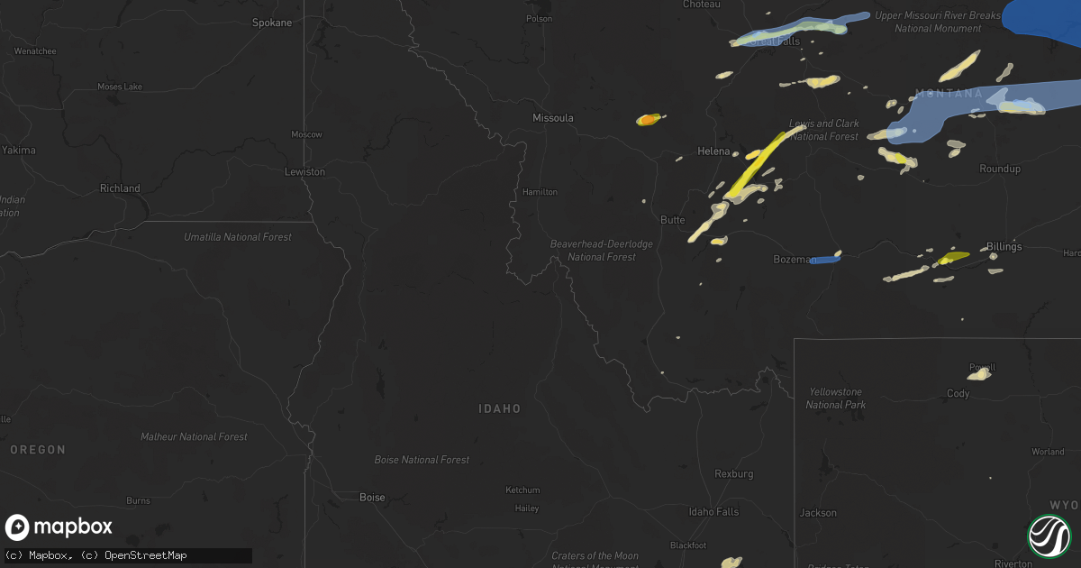
Hail Map in Idaho on July 14, 2019
Get this storm
July 14 map
$229
one time, instant access
Download today. No call, no setup
Keep the $229
Bought the map and want the full workflow? Apply the entire $229 to a subscription within 7 days. None of it is wasted.
Every map, not just this one
This buys you this map. Subscription and you get every map we run, in the markets you choose from a few cities to whole states to nationwide. Plus real-time alerts the moment a storm fires.
Contact data
Name, contact info, occupancy, even credit band for addresses in the footprint. You go from where it hit to who to call.
Become the source they trust
Unlimited branding weather history reports on demand. You already have the documented answer ready for the property owner, and you are the one who showed up with it.
Property data and RoofTrace estimates
Pull up any address you have got, its value and the exact code rules for that jurisdiction, straight from One Click Code. Then RoofTrace estimates the squares, pitch, and roof value, priced the way you price.
Storm reports in Idaho
Idaho
| Date | Description |
|---|---|
| 07/14/20194:49 PM CDT | Quarter size hail found on north indian creek road by off duty nws employee. Time of occurrence estimated from radar. |
| 07/14/20194:47 PM CDT | Quarter size hail found on west portneuf road by off duty nws employee. Time of occurrence estimated from radar. |
| 07/13/201910:44 PM CDT | At 343 PM MDT, a severe thunderstorm was located over Inkom or 10 miles north of McCammon, moving northeast at 25 mph. HAZARD...60 mph wind gusts and quarter size hail. SOURCE...Radar indicated. IMPACT...Hail damage to vehicles is expected. Expect wind damage to roofs, siding, and trees. Locations impacted include... Chesterfield Reservoir, Inkom and Chesterfield. |
All States Impacted by Hail Map on July 14, 2019
Cities Impacted by Hail Map on July 14, 2019
- Baldwin, ND
- Eastman, WI
- Steuben, WI
- Townsend, MT
- Little Falls, MN
- Columbus, MT
- Batavia, IL
- Isle, MN
- Ridgeville, IN
- Farmland, IN
- Winchester, IN
- New Zion, SC
- Pocatello, ID
- Mccammon, ID
- Inkom, ID
- Pine Ridge, SD
- Manderson, SD
- Alliance, NE
- Sheridan, IL
- Serena, IL
- Verona, IL
- Edinburg, ND
- Adams, ND
- Backus, MN
- Hackensack, MN
- Deadwood, SD
- Rapid City, SD
- Harrison, NE
- Crawford, NE
- Marsland, NE
- Browerville, MN
- Stockett, MT
- Elwood, IN
- Windfall, IN
- Firth, ID
- Gilman, WI
- Lublin, WI
- Thorp, WI
- Cushing, MN
- Randall, MN
- Helmville, MT
- Moore, MT
- Highwood, MT
- Dana, IN
- Whitehall, MT
- Torrington, WY
- Clear Lake, SD
- Iroquois, SD
- New Holland, IL
- Alice, TX
- Eagle Butte, SD
- Langdon, ND
- Hobson, MT
- Aitkin, MN
- Hyannis, NE
- Webster Springs, WV
- Fulton, KY
- Tucson, AZ
- Markham, TX
- Bay City, TX
- Seguin, TX
- Buffalo, MT
- Kyle, SD
- Wounded Knee, SD
- Chester, MT
- Joplin, MT
- Rudyard, MT
- Inverness, MT
- Hingham, MT
- Lake Park, MN
- Audubon, MN
- Ellsworth, NE
- Rushville, NE
- Champaign, IL
- Tolono, IL
- Savoy, IL
- Crookston, NE
- Whitman, NE
- San Jose, IL
- Delavan, IL
- Canton, IL
- Manito, IL
- Green Valley, IL
- Glasford, IL
- Emden, IL
- Mission, SD
- Cuba City, WI
- Hazel Green, WI
- Winston, MT
- Pembroke Township, IL
- White Sulphur Springs, MT
- Toston, MT
- Boulder, MT
- Hartford City, IN
- Eaton, IN
- Muncie, IN
- Cassville, WI
- Martinton, IL
- Caledonia, IL
- Loves Park, IL
- Rockford, IL
- Rockville, IN
- Montezuma, IN
- Mount Sterling, KY
- Caputa, SD
- Long Prairie, MN
- Dubuque, IA
- Otis, CO
- Akron, CO
- Big Stone City, SD
- Milbank, SD
- Bellingham, MN
- Odessa, MN
- Ramah, CO
- Sterling, IL
- Polo, IL
- Dixon, IL
- Morocco, IN
- Great Falls, MT
- Detroit Lakes, MN
- Delphi, IN
- Wood, SD
- Valentine, NE
- Box Elder, MT
- Big Sandy, MT
- Gildford, MT
- Sarles, ND
- Walker, MN
- Black Hawk, SD
- Piedmont, SD
- Swanville, MN
- Stanford, MT
- Black Canyon City, AZ
- Sheridan, WY
- Wyola, MT
- Ranchester, WY
- Parkman, WY
- Dayton, WY
- Sharpsburg, KY
- Carlisle, KY
- Hermosa, SD
- Two Dot, MT
- Nemo, SD
- Sturgis, SD
- Powell, WY
- Callaway, MN
- Cardwell, MT
- Three Forks, MT
- Luana, IA
- Monona, IA
- Richardton, ND
- Lake George, MN
- Laporte, MN
- Lavina, MT
- Roy, MT
- Estelline, SD
- Brandt, SD
- Barney, ND
- Colfax, ND
- Walcott, ND
- Joliet, MT
- Pierz, MN
- Lima, MT
- East Helena, MT
- Newark, IL
- Millington, IL
- Lindon, CO
- Cody, NE
- Brainerd, MN
- Garrison, MN
- Fergus Falls, MN
- Ponsford, MN
- Boyes, MT
- New Underwood, SD
- East Dubuque, IL
- De Smet, SD
- La Motte, IA
- Chisago City, MN
- Lindstrom, MN
- Lincoln, IL
- Bowlus, MN
- Oshkosh, NE
- Otter, MT
- Longville, MN
- Remer, MN
- Akeley, MN
- Wahpeton, ND
- Mooreton, ND
- Mcleod, ND
- Wyndmere, ND
- Avon, MT
- Munich, ND
- Rocklake, ND
- Floweree, MT
- Billings, MT
- Huntley, MT
- Hammond, MT
- Artesian, SD
- Gaston, IN
- Tipton, IN
- Camden, IN
- Marietta, OH
- Hawley, MN
- Barnesville, MN
- Sabin, MN
- Cascade, MT
- Naper, NE
- Stuart, NE
- Gardner, IL
- Dwight, IL
- Lead, SD
- Motley, MN
- Malta, ID
- Silver Star, MT
- Hilger, MT
- Absarokee, MT
- Belvidere, IL
- Forest Lake, MN
- Wyoming, MN
- Paris, KY
- Monarch, MT
- Raynesford, MT
- Belt, MT
- Geyser, MT
- Black Eagle, MT
- Milton, ND
- Livingston, MT
- Shawmut, MT
- Judith Gap, MT
- Parsons, WV
- Nisswa, MN
- Sundance, WY
- Spearfish, SD
- Beulah, WY
- Hinckley, IL
- Big Rock, IL
- Elburn, IL
- Maple Park, IL
- Beaverville, IL
- Watseka, IL
- Donovan, IL
- Fort Benton, MT
- Geraldine, MT
- Lake Preston, SD
- Lewistown, MT
- Dawson, ND
- Grass Range, MT
- Baxter, MN
- Lankin, ND
- Marion, IN
- Montpelier, IN
- Loyal, WI
- Laurel, MT
- Holy Cross, IA
- Fordville, ND
- Dalton, MN
- Wahkon, MN
- Soda Springs, ID
- Park Rapids, MN
- Pine River, MN
- Pequot Lakes, MN
- Wabash, IN
- Scandia, MN
- Sun River, MT
- Vaughn, MT
- Power, MT
- Osnabrock, ND
- Barron, WI
- Floresville, TX
- Warren, IN
- Fleming, CO
- Summitville, IN
- Clinton, IL
- Wapella, IL
- Foxhome, MN
- Pine Apple, AL
- Georgiana, AL
- Ogema, MN
- Pelican Rapids, MN
- Rothsay, MN
- Breckenridge, MN
- Fort Shaw, MT
- Peyton, CO
- Hartsburg, IL
- Princeton, MN
- Ashby, NE
- Stacy, MN
- North Branch, MN
- Greencastle, IN
- Fillmore, IN
- Mills, NE
- Staples, MN
- Emily, MN
- Stillwater, MN
- Bayport, MN
- Hudson, WI
- McLean, IL
- Decker, MT
- Yale, SD
- Cavour, SD
- Herscher, IL
- Hebron, ND
- Yorkville, IL
- Geneva, IL
- Winnett, MT
- Winner, SD
- Yuma, CO
- Ironton, MN
- Woodrow, CO
- Elkton, VA
- Ocate, NM
- Thermopolis, WY
- Sebeka, MN
- Anaconda, MT
- Sandwich, IL
- Plano, IL
- Nevis, MN
- Philo, IL
- Verndale, MN
- Osceola, WI
- Mooseheart, IL
- North Aurora, IL
- Nye, MT
- Brook, IN
- Fair Oaks, IN
- Wagon Mound, NM
- Foley, MN
- Milaca, MN
- Free Union, VA
- Rockland, ID
- Medford, WI
- Withee, WI
- Bruce, SD
- Reed Point, MT
- Pearl City, IL
- Molt, MT
- Hansboro, ND
- Sheridan, MT
- Cody, WY
- Tuttle, ND
- Menahga, MN
- Sugar Grove, IL
- Pony, MT
- Chinook, MT
- Choteau, MT
- Dutton, MT
- Bridger, MT
- Belfry, MT
- Bearcreek, MT
- Capitol, MT
- Bellevue, IA
- Wing, ND
- Deerwood, MN
- Hillman, MN
- Fort Ripley, MN
- Saint Charles, IL
- Seymour, IL
- Ivesdale, IL
- Monticello, IL
- Sherrill, IA
- Dupree, SD
- Bingham, NE
- Hemingford, NE
- Harlowton, MT
- Ledger, MT
- Conrad, MT
- Pease, MN
- Perth, ND
- McLeod, MT
- Lincoln, MT
- Heyworth, IL
- Hampshire, IL
- Van Buren, IN
- Kilgore, NE
- Aurora, IL
- Outing, MN
- Dillon, MT
- Chadron, NE
- Greenbush, ME
- Sumrall, MS
- Hattiesburg, MS
- Purvis, MS
- Lumberton, MS
- Erhard, MN
- Park City, MT
- Big Timber, MT
- Jackson, LA
- Ethel, LA
- Slaughter, LA
- Zachary, LA
- Baker, LA
- Baton Rouge, LA
- Denham Springs, LA
- Walker, LA
- Prairieville, LA
- Saint Gabriel, LA
- Greenwell Springs, LA
- Sand Springs, MT
- Forest Grove, MT
- Brusett, MT
- Mosby, MT
- Havre, MT
- Bozeman, MT
- Glasgow, MT
- Malta, MT
- Fort Peck, MT
- Nashua, MT
- Jordan, MT
- Zortman, MT
- Saint Marie, MT
- Fallon, MT
- Angela, MT
- Miles City, MT
- Rosebud, MT
- Bloomfield, MT
- Kinsey, MT
- Wibaux, MT
- Ismay, MT
- Terry, MT
- Baker, MT
- Lindsay, MT
- Willard, MT
- Cohagen, MT
- Volborg, MT
- Plevna, MT
- Glendive, MT
- Mott, ND
- Hazen, ND
- Golden Valley, ND
- New Leipzig, ND
- Lefor, ND
- Dodge, ND
- Halliday, ND
- New Salem, ND
- Medora, ND
- Glen Ullin, ND
- New England, ND
- Gladstone, ND
- Taylor, ND
- South Heart, ND
- Belfield, ND
- Dunn Center, ND
- Zap, ND
- Dickinson, ND
- Mandan, ND
- Manning, ND
- Killdeer, ND
- Amidon, ND
- Beulah, ND
- Regent, ND
- Almont, ND
- Fairfield, ND


