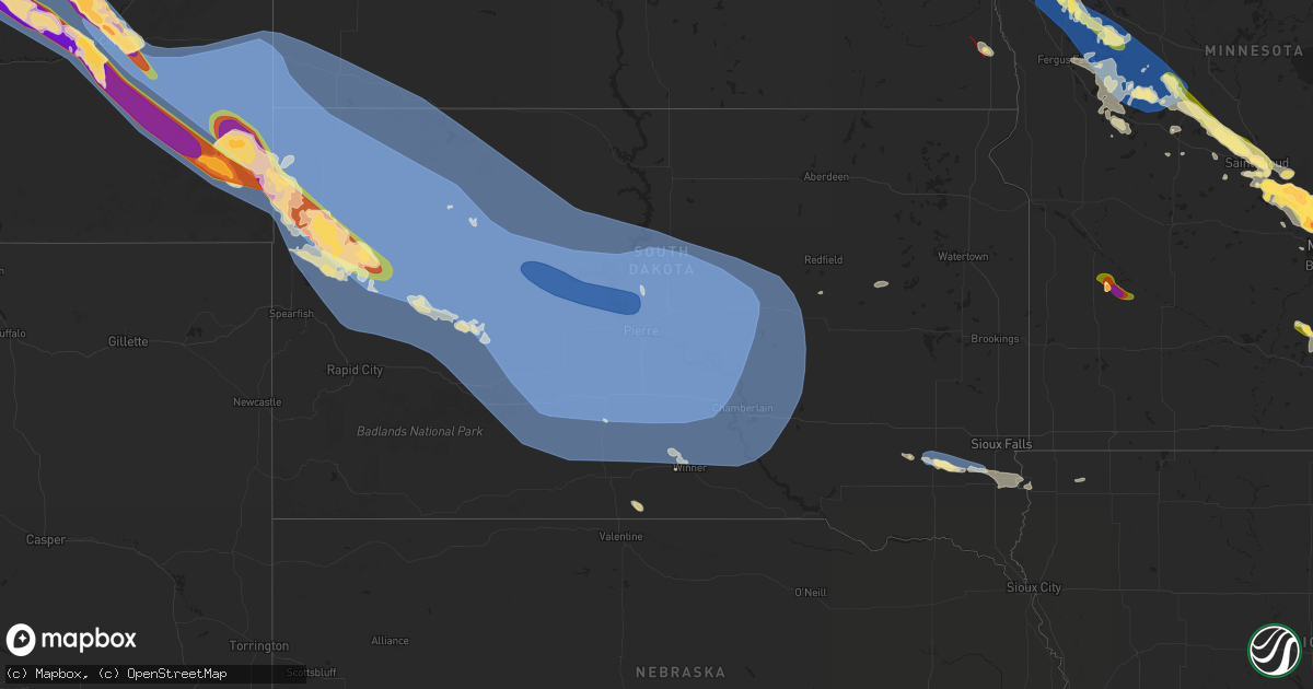
Hail Map in South Dakota on July 13, 2024
Get this storm
July 13 map
$229
one time, instant access
Download today. No call, no setup
Keep the $229
Bought the map and want the full workflow? Apply the entire $229 to a subscription within 7 days. None of it is wasted.
Every map, not just this one
This buys you this map. Subscription and you get every map we run, in the markets you choose from a few cities to whole states to nationwide. Plus real-time alerts the moment a storm fires.
Contact data
Name, contact info, occupancy, even credit band for addresses in the footprint. You go from where it hit to who to call.
Become the source they trust
Unlimited branding weather history reports on demand. You already have the documented answer ready for the property owner, and you are the one who showed up with it.
Property data and RoofTrace estimates
Pull up any address you have got, its value and the exact code rules for that jurisdiction, straight from One Click Code. Then RoofTrace estimates the squares, pitch, and roof value, priced the way you price.
Storm reports in South Dakota
South Dakota
| Date | Description |
|---|---|
| 07/13/20245:15 AM CDT | Small tree and numerous small branches down in beloit. |
| 07/13/20245:10 AM CDT | Numerous large tree limbs down throughout canton... With several power lines down. |
| 07/13/20245:07 AM CDT | An sddot site in davis recorded a 64 mph wind gust. |
| 07/13/20244:40 AM CDT | An sddot site in parker recorded a 64 mph wind gust. |
| 07/13/20243:56 AM CDT | A local report indicates 60 MPH wind near 1 NE Winner |
| 07/13/20243:45 AM CDT | A local report indicates 68 MPH wind near 1 NE Winner |
| 07/13/20243:36 AM CDT | A 62 mph wind gust was recorded at the huron regional airport. |
| 07/13/20243:35 AM CDT | A local report indicates 58 MPH wind near 2 W Hamill |
| 07/13/20243:33 AM CDT | The sddot site at the platte-winner bridge recorded a 68 mph wind gust. |
| 07/13/20243:28 AM CDT | The sddot site in dixon recorded a 72 mph wind gust. |
| 07/13/20243:25 AM CDT | A local report indicates 60 MPH wind near 2 W Hamill |
| 07/13/20243:16 AM CDT | A local report indicates 64 MPH wind near 1 NE Winner |
| 07/13/20243:10 AM CDT | A local report indicates 61 MPH wind near 2 W Hamill |
| 07/13/20243:09 AM CDT | A local report indicates 58 MPH wind near Wewela |
| 07/13/20242:57 AM CDT | The wolsey sddot site recorded a 70 mph wind gust. |
| 07/13/20242:56 AM CDT | A local report indicates 64 MPH wind near 1 NE Winner |
| 07/13/20242:50 AM CDT | A local report indicates 63 MPH wind near 2 W Hamill |
| 07/13/20242:48 AM CDT | The dixon mesonet recorded a 64 mph wind gust. |
| 07/13/20242:39 AM CDT | A local report indicates 62 MPH wind near Wewela |
| 07/13/20242:35 AM CDT | The chamberlain asos recorded a 60 mph wind gust. |
| 07/13/20242:35 AM CDT | A local report indicates 64 MPH wind near 2 W Hamill |
| 07/13/20242:35 AM CDT | Mesonet station ocms2 oacoma 2w |
| 07/13/20242:33 AM CDT | An sddot site in kimball recorded a 58 mph wind gust. |
| 07/13/20242:33 AM CDT | A local report indicates 64 MPH wind near 1 NE Winner |
| 07/13/20242:32 AM CDT | Mesonet station 201 gann valley |
| 07/13/20242:23 AM CDT | Mesonet station 312 ree heights |
| 07/13/20242:22 AM CDT | Mesonet station 289 lees corner |
| 07/13/20242:20 AM CDT | A local report indicates 67 MPH wind near 2 W Hamill |
| 07/13/20242:20 AM CDT | The gregory n mesonet recorded a 61 mph wind gust. |
| 07/13/20242:19 AM CDT | A local report indicates 60 MPH wind near 15 SSE Mission |
| 07/13/20242:17 AM CDT | Mesonet station 215 polo 17 w jct sd47/sd26 |
| 07/13/20242:16 AM CDT | Mesonet station 54 reliance |
| 07/13/20242:15 AM CDT | Mesonet station ocms2 oacoma 2w |
| 07/13/20242:15 AM CDT | A local report indicates 65 MPH wind near 2 W Hamill |
| 07/13/20242:14 AM CDT | A local report indicates 59 MPH wind near 15 SSE Mission |
| 07/13/20242:12 AM CDT | Mesonet station 212 agar |
| 07/13/20242:10 AM CDT | Mesonet station hihs2 highmore |
| 07/13/20242:10 AM CDT | A local report indicates 58 MPH wind near 2 W Hamill |
| 07/13/20242:06 AM CDT | Mesonet station 183 macs corner |
| 07/13/20242:05 AM CDT | A local report indicates 69 MPH wind near 7 ESE Rosebud |
| 07/13/20242:05 AM CDT | Time estimated based on radar |
| 07/13/20242:01 AM CDT | Mesonet station 54 reliance |
| 07/13/20242:01 AM CDT | Mesonet station 183 macs corner |
| 07/13/20241:59 AM CDT | Mesonet station rfps2 vivian 13 n. |
| 07/13/20241:58 AM CDT | Mesonet station 19 harrold |
| 07/13/20241:55 AM CDT | Mesonet station onms2 onida 13wsw |
| 07/13/20241:55 AM CDT | Mesonet station dvi01081 presho. |
| 07/13/20241:52 AM CDT | Mesonet station 285 14w lower brule |
| 07/13/20241:51 AM CDT | Mesonet station 157 forest city |
| 07/13/20241:50 AM CDT | Asos station kpir pierre muni ap. |
| 07/13/20241:47 AM CDT | A local report indicates 59 MPH wind near 9 ENE Belvidere |
| 07/13/20241:43 AM CDT | A local report indicates 65 MPH wind near 10 NNE White River |
| 07/13/20241:41 AM CDT | A local report indicates 58 MPH wind near 1 NE Midland |
| 07/13/20241:38 AM CDT | Mesonet station 13 vivian |
| 07/13/20241:38 AM CDT | A local report indicates 65 MPH wind near 10 NNE White River |
| 07/13/20241:37 AM CDT | A local report indicates 60 MPH wind near 9 ENE Belvidere |
| 07/13/20241:35 AM CDT | Corrects the time from the previous tstm wnd dmg report from 1 nnw fort pierre. Damage to grain bins at local agricultural service. Time estimated based on radar data. |
| 07/13/20241:35 AM CDT | Several campers/travel trailers damaged or overturned at local business. Time estimated based on radar data. |
| 07/13/20241:35 AM CDT | Six 20x20 foot doors blown off local construction company shop. Time estimated based on radar data. |
| 07/13/20241:33 AM CDT | A local report indicates 64 MPH wind near 10 NNE White River |
| 07/13/20241:31 AM CDT | Asos station kpir pierre muni ap. |
| 07/13/20241:30 AM CDT | A local report indicates 59 MPH wind near 4 WNW Cedar Butte |
| 07/13/20241:28 AM CDT | A local report indicates 61 MPH wind near 7 E Wanblee |
| 07/13/20241:27 AM CDT | Mesonet station 185 blunt |
| 07/13/20241:20 AM CDT | Mesonet station onms2 onida 13wsw |
| 07/13/20241:15 AM CDT | A local report indicates 71 MPH wind near 3 ENE Midland |
| 07/13/20241:08 AM CDT | Mesonet station 202 hayes |
| 07/13/20241:05 AM CDT | A local report indicates 59 MPH wind near 2 E Cottonwood |
| 07/13/20241:05 AM CDT | A local report indicates 67 MPH wind near 1 WSW South Eagle Butte |
| 07/13/202412:59 AM CDT | A local report indicates 59 MPH wind near 4 E Cactus Flat |
| 07/13/202412:55 AM CDT | Several large trees down and some structural damage around town. Time estimated from radar. |
| 07/13/202412:55 AM CDT | A local report indicates 59 MPH wind near 6 W Cottonwood |
| 07/13/202412:55 AM CDT | Mesonet station hams2 hayes 7sw |
| 07/13/202412:54 AM CDT | Mesonet station 202 hayes |
| 07/13/202412:54 AM CDT | A local report indicates 66 MPH wind near 10 NNW Ottumwa |
| 07/13/202412:52 AM CDT | Mesonet station lans2 bear creek. |
| 07/13/202412:50 AM CDT | A local report indicates 81 MPH wind near 3 E Philip |
| 07/13/202412:50 AM CDT | A local report indicates 59 MPH wind near 2 E Cottonwood |
| 07/13/202412:50 AM CDT | A local report indicates 78 MPH wind near 1 WSW South Eagle Butte |
| 07/13/202412:50 AM CDT | Mesonet station hams2 hayes 7sw |
| 07/13/202412:49 AM CDT | Mesonet station 168 foster bay |
| 07/13/202412:46 AM CDT | 3 inch tree limbs broken and power poles broken. |
| 07/13/202412:45 AM CDT | Mesonet station dvi03752 hayes. |
| 07/13/202412:44 AM CDT | A local report indicates 64 MPH wind near 3 E Philip |
| 07/13/202412:40 AM CDT | A local report indicates 76 MPH wind near 1 WSW South Eagle Butte |
| 07/13/202412:39 AM CDT | A local report indicates 65 MPH wind near 2 SW Bridger |
| 07/13/202412:39 AM CDT | A local report indicates 93 MPH wind near 10 NNW Ottumwa |
| 07/13/202412:35 AM CDT | A local report indicates 73 MPH wind near 1 WSW South Eagle Butte |
| 07/13/202412:34 AM CDT | A local report indicates 77 MPH wind near 10 NNW Ottumwa |
| 07/13/202412:29 AM CDT | A local report indicates 68 MPH wind near 2 SW Bridger |
| 07/13/202412:24 AM CDT | A local report indicates 58 MPH wind near 3 NW Wasta |
| 07/13/202412:20 AM CDT | A local report indicates 70 MPH wind near 11 W Milesville |
| 07/13/202412:20 AM CDT | Trees uprooted/damaged. Time estimated based on radar data. |
| 07/13/202412:20 AM CDT | Mesonet station lans2 bear creek. Time estimated based on radar data. |
| 07/13/202412:15 AM CDT | Roof partially blown off of barn at dupree rodeo arena. Tree branches and a few power poles down countywide. Time estimated from radar. |
| 07/13/202412:14 AM CDT | A local report indicates 85 MPH wind near 2 SW Bridger |
| 07/13/202412:10 AM CDT | A local report indicates 68 MPH wind near 11 W Milesville |
| 07/13/202412:09 AM CDT | A local report indicates 74 MPH wind near 2 SW Bridger |
| 07/13/202412:04 AM CDT | A local report indicates 58 MPH wind near 5 WNW New Underwood |
| 07/13/202412:00 AM CDT | Reports of downed trees and impassible roads in faith. Winds estimated at 80-90 mph. Time estimated based on radar. |
| 07/12/202411:51 PM CDT | A local report indicates 66 MPH wind near 3 W Union Center |
| 07/12/202411:47 PM CDT | A local report indicates 78 MPH wind near Usta |
| 07/12/202411:45 PM CDT | A local report indicates 84 MPH wind near 6 WSW Fairpoint |
| 07/12/202411:45 PM CDT | A local report indicates 60 MPH wind near 6 WSW Opal |
| 07/12/202411:41 PM CDT | A local report indicates 65 MPH wind near 3 W Union Center |
| 07/12/202411:40 PM CDT | 60-70 mph winds. 4 to 5 inch diameter branches broken off trees. |
| 07/12/202411:40 PM CDT | A local report indicates 67 MPH wind near Union Center |
| 07/12/202411:40 PM CDT | Damage to roof of trailer home. |
| 07/12/202411:35 PM CDT | A local report indicates 61 MPH wind near Union Center |
| 07/12/202411:30 PM CDT | A local report indicates 58 MPH wind near 6 WSW Opal |
| 07/12/202411:30 PM CDT | A local report indicates 83 MPH wind near 9 SE Mud Butte |
| 07/12/202411:25 PM CDT | Correction to time |
| 07/12/202411:25 PM CDT | Time estimated based on radar |
| 07/12/202411:20 PM CDT | A local report indicates 60 MPH wind near Bison |
| 07/12/202411:15 PM CDT | A local report indicates 58 MPH wind near 1 NNW Nisland |
| 07/12/202411:15 PM CDT | A local report indicates 88 MPH wind near 1 ENE Mud Butte |
| 07/12/202411:12 PM CDT | A local report indicates 76 MPH wind near 8 E Prairie City |
| 07/12/202411:09 PM CDT | A local report indicates 59 MPH wind near 7 WSW Hoover |
| 07/12/202411:04 PM CDT | A local report indicates 70 MPH wind near 13 NE Newell |
| 07/12/202410:56 PM CDT | A local report indicates 66 MPH wind near 27 WNW Castle Rock |
| 07/12/202410:56 PM CDT | A local report indicates 70 MPH wind near 13 SSW Reva |
| 07/12/202410:55 PM CDT | A local report indicates 74 MPH wind near 10 W Reva |
| 07/12/202410:55 PM CDT | A local report indicates 102 MPH wind near 12 WSW Castle Rock |
| 07/12/202410:54 PM CDT | A local report indicates 108 MPH wind near 7 WSW Hoover |
| 07/12/202410:50 PM CDT | A local report indicates 64 MPH wind near 10 W Reva |
| 07/12/202410:49 PM CDT | A local report indicates 91 MPH wind near 7 WSW Hoover |
| 07/12/202410:47 PM CDT | A local report indicates 74 MPH wind near 7 NNE Ralph |
| 07/12/202410:45 PM CDT | A local report indicates 61 MPH wind near 14 WNW Lodgepole |
| 07/12/202410:45 PM CDT | A local report indicates 69 MPH wind near 12 WSW Castle Rock |
| 07/12/202410:45 PM CDT | Many trees snapped. Barn roof partially torn off. Stockade damage. Time estimated from radar. |
| 07/12/202410:45 PM CDT | Numerous branches 8-10 inches in diameter broken. Stockade blown down. Hay bales displaced. |
| 07/12/202410:45 PM CDT | A local report indicates 90 MPH wind near 7 E Redig |
| 07/12/202410:44 PM CDT | A local report indicates 67 MPH wind near 7 WSW Hoover |
| 07/12/202410:42 PM CDT | A local report indicates 64 MPH wind near 7 NNE Ralph |
| 07/12/202410:40 PM CDT | Roofs blown off of storage shed and trailer. Time estimated from radar. |
| 07/12/202410:40 PM CDT | A local report indicates 87 MPH wind near 3 N Redig |
| 07/12/202410:25 PM CDT | Two buildings destroyed. Lots of tree and stockade damage. Time estimated from radar. |
| 07/12/202410:20 PM CDT | Photo shows a large hole in siding of a farm outbuilding. Widespread damage reported between harding and camp crook. Time estimated from radar. |
| 07/12/202410:15 PM CDT | A local report indicates 70 MPH wind near 1 ESE Ladner |
All States Impacted by Hail Map on July 13, 2024
Cities Impacted by Hail Map on July 13, 2024
- Clarkfield, MN
- Granite Falls, MN
- Becker, MN
- Blackwater, MO
- Franklin, MO
- Hanley Falls, MN
- Brumley, MO
- Lancaster, MN
- Balfour, ND
- Gilliam, MO
- Cottonwood, MN
- York, ND
- Richland, MO
- Iberia, MO
- Ulman, MO
- Karlsruhe, ND
- Rugby, ND
- Drake, ND
- Natoma, KS
- Montreal, MO
- Stoutland, MO
- Fayette, MO
- Wood Lake, MN
- New Franklin, MO
- Dixon, MO
- Glasgow, MO
- Echo, MN
- Saint Paul Park, MN
- South Saint Paul, MN
- Newport, MN
- Inver Grove Heights, MN
- Cottage Grove, MN
- Afton, MN
- Hastings, MN
- Saint Paul, MN
- Rosemount, MN
- Hermann, MO
- Morrison, MO
- Ponemah, MN
- Slater, MO
- Welch, MN
- Prescott, WI
- Barron, WI
- New Auburn, WI
- Blackduck, MN
- Grovespring, MO
- Hartville, MO
- Phillips, WI
- Park Falls, WI
- Bovey, MN
- Tower, MN
- Independence, LA
- Loranger, LA
- Tickfaw, LA
- Mount Olive, MS
- Stratford, WI
- Colby, WI
- Edgar, WI
- Lena, IL
- Ladysmith, WI
- Athens, WI
- Murphysboro, IL
- Lewisport, KY
- Philpot, KY
- Chinook, MT
- Collins, MS
- Clewiston, FL
- Seminary, MS
- Hager City, WI
- Red Wing, MN
- Antigo, WI
- Mondovi, WI
- Marathon, WI
- Mosinee, WI
- Nelson, WI
- Durand, WI
- Alma, WI
- Bay City, WI
- Saucier, MS
- Abbotsford, WI
- Dorchester, WI
- Cortland, OH
- Harlem, MT
- Wausau, WI
- Barstow, CA
- Hays, MT
- Fountain City, WI
- Cochrane, WI
- Labelle, FL
- Arcadia, WI
- Havre, MT
- Birnamwood, WI
- Rothschild, WI
- Plainview, MN
- Hatley, WI
- Faribault, MN
- Kenyon, MN
- Nerstrand, MN
- Le Center, MN
- Le Sueur, MN
- Kilkenny, MN
- Altura, MN
- Kellogg, MN
- Dodson, MT
- Bowler, WI
- Rosholt, WI
- Wittenberg, WI
- Winona, MN
- Trempealeau, WI
- Galesville, WI
- Holmen, WI
- Eland, WI
- New Middletown, IN
- Elizabeth, IN
- Corydon, IN
- Dodge, WI
- Dakota, MN
- Coxs Creek, KY
- Mojave, CA
- Onalaska, WI
- Minnesota City, MN
- Rollingstone, MN
- Malta, MT
- Zortman, MT
- Iola, WI
- Tigerton, WI
- Sublette, IL
- Midway, TX
- La Crescent, MN
- West Salem, WI
- West Brooklyn, IL
- Cantil, CA
- La Crosse, WI
- Brusett, MT
- Plum City, WI
- Winnett, MT
- Rockland, WI
- Bangor, WI
- Crockett, TX
- Centerville, TX
- Foxworth, MS
- Maiden Rock, WI
- Pepin, WI
- Stockholm, WI
- Black Creek, WI
- Sparta, WI
- Bear Creek, WI
- Shiocton, WI
- Humble, TX
- Stoddard, WI
- Chaseburg, WI
- Coon Valley, WI
- Norwalk, WI
- Westby, WI
- Cashton, WI
- Ontario, WI
- La Farge, WI
- Viroqua, WI
- Viola, WI
- Kendall, WI
- Hillsboro, WI
- Kingwood, TX
- Jordan, MT
- Sand Springs, MT
- Lloyd, MT
- Stevens Point, WI
- Prospect, KY
- Plover, WI
- Bancroft, WI
- Almond, WI
- Dodge Center, MN
- Byron, MN
- Mantorville, MN
- Kasson, MN
- Rochester, MN
- Grand Meadow, MN
- Stewartville, MN
- Racine, MN
- Hayfield, MN
- Chatfield, MN
- Spring Valley, MN
- Cohagen, MT
- Circle, MT
- Hancock, WI
- Coloma, WI
- Lake City, MN
- Wabasha, MN
- Amherst, WI
- Forsyth, MT
- Northfield, MN
- Waupaca, WI
- Plainfield, WI
- Wild Rose, WI
- Westfield, WI
- Wautoma, WI
- Dennison, MN
- Alpine, TX
- Wykoff, MN
- Le Roy, MN
- Preston, MN
- Fountain, MN
- Lanesboro, MN
- Harmony, MN
- Ostrander, MN
- Lone Rock, WI
- Plain, WI
- Readstown, WI
- Richland Center, WI
- Hillpoint, WI
- Spring Green, WI
- Cazenovia, WI
- Arlington, WI
- Poynette, WI
- Wonewoc, WI
- Prairie Du Sac, WI
- Merrimac, WI
- Baraboo, WI
- Fall River, WI
- La Valle, WI
- Loganville, WI
- Dane, WI
- North Freedom, WI
- Lodi, WI
- Arena, WI
- Rock Springs, WI
- Lime Ridge, WI
- Sauk City, WI
- Reedsburg, WI
- Portage, WI
- Columbus, WI
- Rio, WI
- Mazomanie, WI
- Rosebud, MT
- Angela, MT
- Kinsey, MT
- Neshkoro, WI
- Montello, WI
- Montgomery, MN
- Neenah, WI
- Appleton, WI
- Fort Davis, TX
- Weyauwega, WI
- Elgin, MN
- Princeton, WI
- Fort Peck, MT
- Berlin, WI
- Dalton, WI
- Pine River, WI
- Kimberly, WI
- Mooreton, ND
- Kingston, WI
- Randolph, WI
- Friesland, WI
- Cambria, WI
- Markesan, WI
- Green Lake, WI
- Hampton, MN
- Randolph, MN
- Jacumba, CA
- Lonsdale, MN
- Monticello, MS
- Sontag, MS
- Wesson, MS
- Pinola, MS
- Braxton, MS
- Squaw Lake, MN
- Max, MN
- Volborg, MT
- Miles City, MT
- Ismay, MT
- Terry, MT
- Fox Lake, WI
- Cannon Falls, MN
- Farmington, MN
- Avoca, WI
- Mendenhall, MS
- Blue Mounds, WI
- Black Earth, WI
- Cross Plains, WI
- Glyndon, MN
- Chilton, WI
- Pardeeville, WI
- Van Dyne, WI
- Rosendale, WI
- Oshkosh, WI
- Brandon, WI
- Ripon, WI
- Wisconsin Dells, WI
- Fairwater, WI
- Eldorado, WI
- Pickett, WI
- Marquette, WI
- Endeavor, WI
- Wyocena, WI
- Waupun, WI
- Fond Du Lac, WI
- Brownsville, WI
- Beaver Dam, WI
- Mayville, WI
- Oakfield, WI
- Malone, WI
- Campbellsport, WI
- Lomira, WI
- Burnett, WI
- Eden, WI
- Mount Calvary, WI
- Mount Horeb, WI
- Deforest, WI
- Madison, WI
- Verona, WI
- Middleton, WI
- Barneveld, WI
- Sun Prairie, WI
- Mcfarland, WI
- Waunakee, WI
- Cottage Grove, WI
- Lime Springs, IA
- Cresco, IA
- Canton, MN
- Port Washington, WI
- Fredonia, WI
- Belgium, WI
- Adell, WI
- Cascade, WI
- Waldo, WI
- Saukville, WI
- Kewaskum, WI
- Allenton, WI
- West Bend, WI
- Saint Cloud, WI
- Random Lake, WI
- Glenbeulah, WI
- Plymouth, WI
- New Holstein, WI
- Elkhart Lake, WI
- Sheboygan Falls, WI
- Oostburg, WI
- Cedar Grove, WI
- Kiel, WI
- Sheboygan, WI
- Kohler, WI
- Cleveland, WI
- Newton, WI
- Argyle, WI
- Blanchardville, WI
- Stoughton, WI
- Hollandale, WI
- Bristolville, OH
- Oregon, WI
- Kendall, KS
- New Glarus, WI
- Monticello, WI
- Belleville, WI
- Goodhue, MN
- Waterville, MN
- Morristown, MN
- Julian, CA
- Brooklyn, WI
- Medford, MN
- West Concord, MN
- Ferryville, WI
- Luana, IA
- Clermont, IA
- Postville, IA
- Monona, IA
- De Soto, WI
- Saint Olaf, IA
- Waterville, IA
- Waukon, IA
- Farmersburg, IA
- Harpers Ferry, IA
- Elgin, IA
- Eastman, WI
- Castalia, IA
- Lansing, IA
- Bagley, WI
- Garnavillo, IA
- Steuben, WI
- Prairie Du Chien, WI
- Wauzeka, WI
- Guttenberg, IA
- Elkader, IA
- McGregor, IA
- Gays Mills, WI
- Marquette, IA
- Mount Hope, WI
- Boscobel, WI
- Patch Grove, WI
- Bloomington, WI
- Glen Haven, WI
- Woodman, WI
- Pelican Rapids, MN
- Lake Park, MN
- Hawley, MN
- Ottertail, MN
- Dent, MN
- Battle Lake, MN
- Vergas, MN
- Richville, MN
- Erhard, MN
- Biddle, MT
- Hammond, MT
- Ekalaka, MT
- Powderville, MT
- Boyes, MT
- Grand Marsh, WI
- Oxford, WI
- Owatonna, MN
- Baker, MT
- Willard, MT
- Plevna, MT
- Northome, MN
- Barnesville, MN
- Rothsay, MN
- Detroit Lakes, MN
- Perham, MN
- Ashby, MN
- Underwood, MN
- Fergus Falls, MN
- Clitherall, MN
- Evansville, MN
- Henning, MN
- Capitol, MT
- Buffalo, SD
- Camp Crook, SD
- Alzada, MT
- Bowman, ND
- Rhame, ND
- Marmarth, ND
- Waseca, MN
- Juda, WI
- Monroe, WI
- Nunnelly, TN
- Claremont, MN
- Mazeppa, MN
- Zumbro Falls, MN
- Spring Lake, MN
- Yosemite National Park, CA
- Belle Fourche, SD
- Ludlow, SD
- Scranton, ND
- Prairie City, SD
- Ralph, SD
- Reva, SD
- Hettinger, ND
- Lodgepole, SD
- Reeder, ND
- Deer Creek, MN
- Parkers Prairie, MN
- Bertha, MN
- Miltona, MN
- Brandon, MN
- New York Mills, MN
- Garfield, MN
- Clarissa, MN
- Eagle Bend, MN
- Vining, MN
- Hewitt, MN
- Browerville, MN
- Lancaster, WI
- Cassville, WI
- Fennimore, WI
- Blooming Prairie, MN
- Newell, SD
- Saint Cloud, MN
- Dexter, MN
- Briggsville, WI
- Waltham, MN
- Sargeant, MN
- Fosston, MN
- Bejou, MN
- Borup, MN
- Pueblo, CO
- Colfax, ND
- Perley, MN
- Hendrum, MN
- Ada, MN
- Barney, ND
- Wahpeton, ND
- Georgetown, MN
- Felton, MN
- Ulen, MN
- Ogema, MN
- Callaway, MN
- Mahnomen, MN
- Richmond, MN
- Cold Spring, MN
- Rockville, MN
- Union Center, SD
- Mud Butte, SD
- Faith, SD
- Nisland, SD
- Vale, SD
- Sturgis, SD
- Whitewood, SD
- Meadow, SD
- Lemmon, SD
- Bison, SD
- New Underwood, SD
- Enning, SD
- Long Prairie, MN
- Burtrum, MN
- Grey Eagle, MN
- Freeport, MN
- Albany, MN
- Holdingford, MN
- Avon, MN
- Swanville, MN
- Upsala, MN
- Sartell, MN
- Bowlus, MN
- Saint Joseph, MN
- Sauk Rapids, MN
- Little Falls, MN
- Saint Stephen, MN
- Rice, MN
- Clearwater, MN
- Clear Lake, MN
- Monticello, MN
- Big Lake, MN
- Audubon, MN
- Cherry Valley, IL
- Rockford, IL
- Genoa, IL
- Garden Prairie, IL
- Belvidere, IL
- Winnebago, IL
- Alexandria, MN
- Osakis, MN
- Carlos, MN
- Nelson, MN
- Lake Elmo, MN
- Durand, IL
- Pecatonica, IL
- Leaf River, IL
- Dalton, MN
- Maple Lake, MN
- Buffalo, MN
- Annandale, MN
- Elk River, MN
- Hanover, MN
- Rogers, MN
- Albertville, MN
- Saint Michael, MN
- Brownsdale, MN
- Byron, IL
- Elkton, MN
- Austin, MN
- Greenfield, IN
- Morristown, IN
- Fountaintown, IN
- Maple Grove, MN
- Hamel, MN
- Loretto, MN
- Osseo, MN
- Anoka, MN
- Dayton, MN
- Dupree, SD
- Howes, SD
- Midland, SD
- Cherry Creek, SD
- Milesville, SD
- White Owl, SD
- Wasta, SD
- Hayes, SD
- Wall, SD
- Eagle Butte, SD
- Keldron, SD
- Lantry, SD
- Timber Lake, SD
- Isabel, SD
- McIntosh, SD
- Philip, SD
- Quinn, SD
- Elmwood, WI
- Waite Park, MN
- Menomonie, WI
- Ellsworth, WI
- Davis Junction, IL
- Rockford, MN
- Stillman Valley, IL
- Sauk Centre, MN
- Oregon, IL
- Chana, IL
- Kensington, MN
- Minneapolis, MN
- Champlin, MN
- Owanka, SD
- Waverly, MN
- Hudson, WI
- Roberts, WI
- Spring Valley, WI
- Beldenville, WI
- New Richmond, WI
- Lowry, MN
- Farwell, MN
- Star Prairie, WI
- Deer Park, WI
- Steger, IL
- Somerset, WI
- Houlton, WI
- Melrose, WI
- Glenwood City, WI
- River Falls, WI
- Arkansaw, WI
- Eau Galle, WI
- South Haven, MN
- Brooten, MN
- Forest Lake, MN
- Kimball, MN
- Osceola, WI
- Marine On Saint Croix, MN
- Hammond, WI
- Baldwin, WI
- Downing, WI
- Circle Pines, MN
- Monroe Center, IL
- Lindenwood, IL
- Bayport, MN
- Stillwater, MN
- Fort Pierre, SD
- Kadoka, SD
- Ridgeview, SD
- Wilson, WI
- Mindoro, WI
- Amery, WI
- Malta, IL
- Beecher, IL
- Crete, IL
- Woodville, WI
- Pierre, SD
- Wanblee, SD
- Murdo, SD
- Onida, SD
- Draper, SD
- Belvidere, SD
- Gettysburg, SD
- Long Valley, SD
- Agar, SD
- Okaton, SD
- Hugo, MN
- Eden Prairie, MN
- Hopkins, MN
- Shakopee, MN
- Chanhassen, MN
- Minnetonka, MN
- Prior Lake, MN
- Burnsville, MN
- Lakeville, MN
- Mendota, MN
- Savage, MN
- Chaska, MN
- Ettrick, WI
- Dekalb, IL
- White River, SD
- Interior, SD
- Blunt, SD
- Vivian, SD
- Presho, SD
- Norris, SD
- Harrold, SD
- Lee, IL
- Shabbona, IL
- Hinckley, IL
- Naperville, IL
- Plainfield, IL
- Aurora, IL
- Independence, WI
- Lower Brule, SD
- Witten, SD
- Winner, SD
- Reliance, SD
- Ideal, SD
- Gregory, SD
- Kennebec, SD
- Wood, SD
- Hamill, SD
- Fort Thompson, SD
- Highmore, SD
- Holabird, SD
- Seneca, SD
- Lebanon, SD
- Burke, SD
- Dallas, SD
- Chamberlain, SD
- Stephan, SD
- Oacoma, SD
- Gann Valley, SD
- Pukwana, SD
- Ree Heights, SD
- Platte, SD
- Miller, SD
- Orient, SD
- Blair, WI
- Frontenac, MN
- Millville, MN
- Winger, MN
- Kimball, SD
- Wessington, SD
- Wessington Springs, SD
- Saint Lawrence, SD
- White Lake, SD
- Kelliher, MN
- Dover, MN
- Houston, MN
- Saint Charles, MN
- Hokah, MN
- Elroy, WI
- Wilton, WI
- Tulare, SD
- Atkinson, NE
- Stuart, NE
- Mauston, WI
- Genoa, WI
- Lyndon Station, WI
- Emery, SD
- Doland, SD
- Carpenter, SD
- New Lisbon, WI
- Camp Douglas, WI
- Verdigre, NE
- Soldiers Grove, WI
- Bridgewater, SD
- Marion, SD
- Freeman, SD
- Blue River, WI
- Parker, SD
- Chancellor, SD
- Lennox, SD
- Canton, SD
- Beresford, SD
- Worthing, SD
- Platteville, WI
- Inwood, IA
- Fairview, SD
- Rock Valley, IA
- Marshall, WI
- Cuba City, WI
- Belmont, WI
- Shullsburg, WI
- Albany, WI
- Mission, SD
- Brodhead, WI
- Deerfield, WI
- Mound, MN
- Maple Plain, MN
- Browntown, WI
- Montrose, MN
- Evansville, WI
- Gratiot, WI
- Darlington, WI
- Warren, IL
- South Wayne, WI
- Long Lake, MN
- Edgerton, WI
- Janesville, WI
- Waterloo, WI
- George, IA
- Jefferson, WI
- Johnson Creek, WI
- Fort Atkinson, WI
- Lake Mills, WI
- Orangeville, IL
- Winslow, IL
- Watertown, WI
- Freeport, IL
- Shannon, IL
- Lanark, IL
- Whitewater, WI
- Ashton, IA
- German Valley, IL
- Wyanet, IL
- Pearl City, IL
- Baileyville, IL
- Mount Morris, IL
- Forreston, IL
- Amboy, IL
- Ashton, IL
- Franklin Grove, IL


