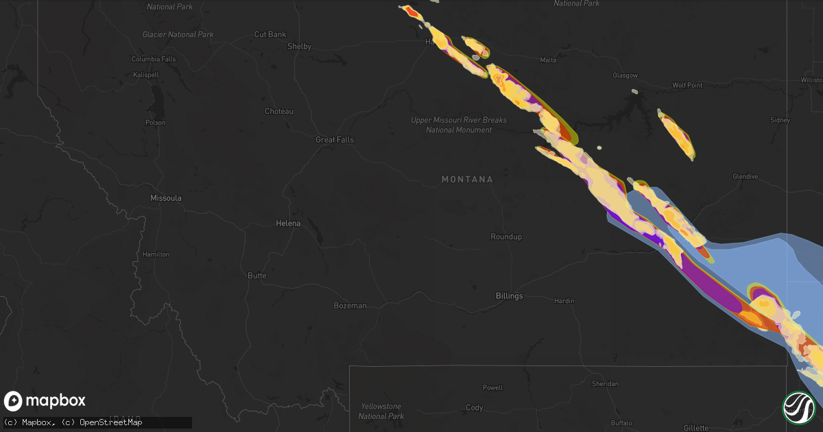
Hail Map in Montana on July 13, 2024
Get this storm
July 13 map
$229
one time, instant access
Download today. No call, no setup
Keep the $229
Bought the map and want the full workflow? Apply the entire $229 to a subscription within 7 days. None of it is wasted.
Every map, not just this one
This buys you this map. Subscription and you get every map we run, in the markets you choose from a few cities to whole states to nationwide. Plus real-time alerts the moment a storm fires.
Contact data
Name, contact info, occupancy, even credit band for addresses in the footprint. You go from where it hit to who to call.
Become the source they trust
Unlimited branding weather history reports on demand. You already have the documented answer ready for the property owner, and you are the one who showed up with it.
Property data and RoofTrace estimates
Pull up any address you have got, its value and the exact code rules for that jurisdiction, straight from One Click Code. Then RoofTrace estimates the squares, pitch, and roof value, priced the way you price.
Storm reports in Montana
Montana
| Date | Description |
|---|---|
| 07/13/20246:50 PM CDT | Mesonet station dw0807 circle. |
| 07/13/20246:45 PM CDT | Mesonet station mtluf 4.4 w sand springs |
| 07/13/20246:45 PM CDT | Reported via facebook. |
| 07/13/20246:45 PM CDT | Public report... Via facebook. |
| 07/13/20246:41 PM CDT | Mesonet station mcdm8 manning corral dogtown. Recorded sometime in the hour between 4:41 and 5:41 pm. |
| 07/13/20246:30 PM CDT | Relayed via fb. Also recorded 8 tenths of rain in a 20 minute period with strong winds |
| 07/13/20246:30 PM CDT | Observed at the sand springs nw hydromet site from the montana mesonets. |
| 07/13/20246:11 PM CDT | Public reported... Via facebook... Golf ball size hail. |
| 07/13/20245:52 PM CDT | 4-inch diameter tree limbs downed. Building frame under construction knocked down. |
| 07/13/20245:52 PM CDT | Photos showing pontoon boat blown onto a trailer... Rv campers tipped over... And verbal reports of a fence damaged. |
| 07/13/20245:40 PM CDT | Quarter to golf ball sized hail was reported by a trained spotter. Hail was reported as completely covering the ground. |
| 07/13/20245:35 PM CDT | Report from social media showing golf ball to egg sized hail that lasted from 423 pm to 435 pm. Public reported 0.2 inches of rain with the storm. |
| 07/13/20245:30 PM CDT | Reported via facebook. |
| 07/13/20245:30 PM CDT | Report of golf ball to baseball size hail that lasted from about 420 pm to 430 pm. Hail completely covered the ground. |
| 07/13/20245:25 PM CDT | Reported via social media with images. Time estimated by radar. |
| 07/13/20245:22 PM CDT | Asos station khvr havre airport. |
| 07/13/20245:18 PM CDT | Corrects previous tstm wnd gst report from 4 w havre. Asos station khvr havre airport. Corrected time. |
| 07/13/20245:15 PM CDT | Public reported golf ball size hail and 0.8 inch rainfall. |
| 07/13/20245:00 PM CDT | Lots of baseball size hail with a few softball size hail mixed in. Lots of wind. |
| 07/13/20244:50 PM CDT | Reported via facebook. Egg to tennis ball sized hail caused damage to windows. Time approximated based on radar. |
| 07/13/20244:38 PM CDT | Reported via facebook with image. Location estimated based upon radar. |
| 07/13/20244:30 PM CDT | Corrects previous hail report from 11 n hays. Lots of baseball size hail with a few softball size hail mixed in. Lots of wind. Time approximated from radar and correcte |
| 07/13/20244:20 PM CDT | Mixed sized hail with the largest being quarters fell for approximately 10 minutes. |
| 07/13/20244:15 PM CDT | Report on social media. Location estimated based on the report time given by the public and radar data. |
| 07/13/20243:40 PM CDT | Report from mping: quarter |
| 07/13/20243:14 PM CDT | Report from mping: quarter |
| 07/13/20242:55 PM CDT | Spotter measured 0.11 inches of rain with the storm. |
| 07/12/202410:00 PM CDT | Spotter had a broken window in his home. Not sure if it was from wind or hail. |
| 07/12/202410:00 PM CDT | Numerous power poles snapped in two. |
| 07/12/20249:58 PM CDT | 60 to 70 mph winds. |
| 07/12/20249:58 PM CDT | A local report indicates 70 MPH wind near 4 N Belltower |
| 07/12/20249:55 PM CDT | A local report indicates 63 MPH wind near 15 SE Ekalaka |
| 07/12/20249:51 PM CDT | A local report indicates 60 MPH wind near 1 E Ridgeway |
| 07/12/20249:40 PM CDT | Mesonet station ktfm8 knowlton. |
| 07/12/20249:25 PM CDT | Power poles down. |
| 07/12/20249:25 PM CDT | Power poles down. Large tree limbs down. |
| 07/12/20249:22 PM CDT | Asos station kbhk baker. |
| 07/12/20249:15 PM CDT | Mesonet station mteka baker mt-7 mp 14.2. |
| 07/12/20249:15 PM CDT | Mesonet station mtm39 4.7 e plevna |
| 07/12/20248:39 PM CDT | South sawmill creek raws site... Between 4:08 and 5:08 pm. |
| 07/12/20248:30 PM CDT | *** 3 inj *** several injuries due to trees falling on people and vehicles. At least one person hospitalized. No fatalities. |
| 07/12/20248:30 PM CDT | A local report indicates 77 MPH wind near 8 SE Tusler |
| 07/12/20248:28 PM CDT | Trees uprooted or snapped; roof blown off. |
| 07/12/20248:22 PM CDT | 3-inch tree limbs broken; power poles broken. |
| 07/12/20248:21 PM CDT | 1-inch tree limbs broken; shingles blown off. |
| 07/12/20248:16 PM CDT | A local report indicates 70 MPH wind near 4 NE Miles City |
| 07/12/20248:15 PM CDT | Fort keogh se mesonet. |
| 07/12/20248:10 PM CDT | Measured by storm spotter. |
| 07/12/20248:08 PM CDT | Tree and power line damage. Power out in miles city. |
| 07/12/20247:15 PM CDT | Reported via facebook with image. |
| 07/12/20247:00 PM CDT | Reported via facebook with images. Also windows broken in mobile home due to hail. |
All States Impacted by Hail Map on July 13, 2024
Cities Impacted by Hail Map on July 13, 2024
- Clarkfield, MN
- Granite Falls, MN
- Becker, MN
- Blackwater, MO
- Franklin, MO
- Hanley Falls, MN
- Brumley, MO
- Lancaster, MN
- Balfour, ND
- Gilliam, MO
- Cottonwood, MN
- York, ND
- Richland, MO
- Iberia, MO
- Ulman, MO
- Karlsruhe, ND
- Rugby, ND
- Drake, ND
- Natoma, KS
- Montreal, MO
- Stoutland, MO
- Fayette, MO
- Wood Lake, MN
- New Franklin, MO
- Dixon, MO
- Glasgow, MO
- Echo, MN
- Saint Paul Park, MN
- South Saint Paul, MN
- Newport, MN
- Inver Grove Heights, MN
- Cottage Grove, MN
- Afton, MN
- Hastings, MN
- Saint Paul, MN
- Rosemount, MN
- Hermann, MO
- Morrison, MO
- Ponemah, MN
- Slater, MO
- Welch, MN
- Prescott, WI
- Barron, WI
- New Auburn, WI
- Blackduck, MN
- Grovespring, MO
- Hartville, MO
- Phillips, WI
- Park Falls, WI
- Bovey, MN
- Tower, MN
- Independence, LA
- Loranger, LA
- Tickfaw, LA
- Mount Olive, MS
- Stratford, WI
- Colby, WI
- Edgar, WI
- Lena, IL
- Ladysmith, WI
- Athens, WI
- Murphysboro, IL
- Lewisport, KY
- Philpot, KY
- Chinook, MT
- Collins, MS
- Clewiston, FL
- Seminary, MS
- Hager City, WI
- Red Wing, MN
- Antigo, WI
- Mondovi, WI
- Marathon, WI
- Mosinee, WI
- Nelson, WI
- Durand, WI
- Alma, WI
- Bay City, WI
- Saucier, MS
- Abbotsford, WI
- Dorchester, WI
- Cortland, OH
- Harlem, MT
- Wausau, WI
- Barstow, CA
- Hays, MT
- Fountain City, WI
- Cochrane, WI
- Labelle, FL
- Arcadia, WI
- Havre, MT
- Birnamwood, WI
- Rothschild, WI
- Plainview, MN
- Hatley, WI
- Faribault, MN
- Kenyon, MN
- Nerstrand, MN
- Le Center, MN
- Le Sueur, MN
- Kilkenny, MN
- Altura, MN
- Kellogg, MN
- Dodson, MT
- Bowler, WI
- Rosholt, WI
- Wittenberg, WI
- Winona, MN
- Trempealeau, WI
- Galesville, WI
- Holmen, WI
- Eland, WI
- New Middletown, IN
- Elizabeth, IN
- Corydon, IN
- Dodge, WI
- Dakota, MN
- Coxs Creek, KY
- Mojave, CA
- Onalaska, WI
- Minnesota City, MN
- Rollingstone, MN
- Malta, MT
- Zortman, MT
- Iola, WI
- Tigerton, WI
- Sublette, IL
- Midway, TX
- La Crescent, MN
- West Salem, WI
- West Brooklyn, IL
- Cantil, CA
- La Crosse, WI
- Brusett, MT
- Plum City, WI
- Winnett, MT
- Rockland, WI
- Bangor, WI
- Crockett, TX
- Centerville, TX
- Foxworth, MS
- Maiden Rock, WI
- Pepin, WI
- Stockholm, WI
- Black Creek, WI
- Sparta, WI
- Bear Creek, WI
- Shiocton, WI
- Humble, TX
- Stoddard, WI
- Chaseburg, WI
- Coon Valley, WI
- Norwalk, WI
- Westby, WI
- Cashton, WI
- Ontario, WI
- La Farge, WI
- Viroqua, WI
- Viola, WI
- Kendall, WI
- Hillsboro, WI
- Kingwood, TX
- Jordan, MT
- Sand Springs, MT
- Lloyd, MT
- Stevens Point, WI
- Prospect, KY
- Plover, WI
- Bancroft, WI
- Almond, WI
- Dodge Center, MN
- Byron, MN
- Mantorville, MN
- Kasson, MN
- Rochester, MN
- Grand Meadow, MN
- Stewartville, MN
- Racine, MN
- Hayfield, MN
- Chatfield, MN
- Spring Valley, MN
- Cohagen, MT
- Circle, MT
- Hancock, WI
- Coloma, WI
- Lake City, MN
- Wabasha, MN
- Amherst, WI
- Forsyth, MT
- Northfield, MN
- Waupaca, WI
- Plainfield, WI
- Wild Rose, WI
- Westfield, WI
- Wautoma, WI
- Dennison, MN
- Alpine, TX
- Wykoff, MN
- Le Roy, MN
- Preston, MN
- Fountain, MN
- Lanesboro, MN
- Harmony, MN
- Ostrander, MN
- Lone Rock, WI
- Plain, WI
- Readstown, WI
- Richland Center, WI
- Hillpoint, WI
- Spring Green, WI
- Cazenovia, WI
- Arlington, WI
- Poynette, WI
- Wonewoc, WI
- Prairie Du Sac, WI
- Merrimac, WI
- Baraboo, WI
- Fall River, WI
- La Valle, WI
- Loganville, WI
- Dane, WI
- North Freedom, WI
- Lodi, WI
- Arena, WI
- Rock Springs, WI
- Lime Ridge, WI
- Sauk City, WI
- Reedsburg, WI
- Portage, WI
- Columbus, WI
- Rio, WI
- Mazomanie, WI
- Rosebud, MT
- Angela, MT
- Kinsey, MT
- Neshkoro, WI
- Montello, WI
- Montgomery, MN
- Neenah, WI
- Appleton, WI
- Fort Davis, TX
- Weyauwega, WI
- Elgin, MN
- Princeton, WI
- Fort Peck, MT
- Berlin, WI
- Dalton, WI
- Pine River, WI
- Kimberly, WI
- Mooreton, ND
- Kingston, WI
- Randolph, WI
- Friesland, WI
- Cambria, WI
- Markesan, WI
- Green Lake, WI
- Hampton, MN
- Randolph, MN
- Jacumba, CA
- Lonsdale, MN
- Monticello, MS
- Sontag, MS
- Wesson, MS
- Pinola, MS
- Braxton, MS
- Squaw Lake, MN
- Max, MN
- Volborg, MT
- Miles City, MT
- Ismay, MT
- Terry, MT
- Fox Lake, WI
- Cannon Falls, MN
- Farmington, MN
- Avoca, WI
- Mendenhall, MS
- Blue Mounds, WI
- Black Earth, WI
- Cross Plains, WI
- Glyndon, MN
- Chilton, WI
- Pardeeville, WI
- Van Dyne, WI
- Rosendale, WI
- Oshkosh, WI
- Brandon, WI
- Ripon, WI
- Wisconsin Dells, WI
- Fairwater, WI
- Eldorado, WI
- Pickett, WI
- Marquette, WI
- Endeavor, WI
- Wyocena, WI
- Waupun, WI
- Fond Du Lac, WI
- Brownsville, WI
- Beaver Dam, WI
- Mayville, WI
- Oakfield, WI
- Malone, WI
- Campbellsport, WI
- Lomira, WI
- Burnett, WI
- Eden, WI
- Mount Calvary, WI
- Mount Horeb, WI
- Deforest, WI
- Madison, WI
- Verona, WI
- Middleton, WI
- Barneveld, WI
- Sun Prairie, WI
- Mcfarland, WI
- Waunakee, WI
- Cottage Grove, WI
- Lime Springs, IA
- Cresco, IA
- Canton, MN
- Port Washington, WI
- Fredonia, WI
- Belgium, WI
- Adell, WI
- Cascade, WI
- Waldo, WI
- Saukville, WI
- Kewaskum, WI
- Allenton, WI
- West Bend, WI
- Saint Cloud, WI
- Random Lake, WI
- Glenbeulah, WI
- Plymouth, WI
- New Holstein, WI
- Elkhart Lake, WI
- Sheboygan Falls, WI
- Oostburg, WI
- Cedar Grove, WI
- Kiel, WI
- Sheboygan, WI
- Kohler, WI
- Cleveland, WI
- Newton, WI
- Argyle, WI
- Blanchardville, WI
- Stoughton, WI
- Hollandale, WI
- Bristolville, OH
- Oregon, WI
- Kendall, KS
- New Glarus, WI
- Monticello, WI
- Belleville, WI
- Goodhue, MN
- Waterville, MN
- Morristown, MN
- Julian, CA
- Brooklyn, WI
- Medford, MN
- West Concord, MN
- Ferryville, WI
- Luana, IA
- Clermont, IA
- Postville, IA
- Monona, IA
- De Soto, WI
- Saint Olaf, IA
- Waterville, IA
- Waukon, IA
- Farmersburg, IA
- Harpers Ferry, IA
- Elgin, IA
- Eastman, WI
- Castalia, IA
- Lansing, IA
- Bagley, WI
- Garnavillo, IA
- Steuben, WI
- Prairie Du Chien, WI
- Wauzeka, WI
- Guttenberg, IA
- Elkader, IA
- McGregor, IA
- Gays Mills, WI
- Marquette, IA
- Mount Hope, WI
- Boscobel, WI
- Patch Grove, WI
- Bloomington, WI
- Glen Haven, WI
- Woodman, WI
- Pelican Rapids, MN
- Lake Park, MN
- Hawley, MN
- Ottertail, MN
- Dent, MN
- Battle Lake, MN
- Vergas, MN
- Richville, MN
- Erhard, MN
- Biddle, MT
- Hammond, MT
- Ekalaka, MT
- Powderville, MT
- Boyes, MT
- Grand Marsh, WI
- Oxford, WI
- Owatonna, MN
- Baker, MT
- Willard, MT
- Plevna, MT
- Northome, MN
- Barnesville, MN
- Rothsay, MN
- Detroit Lakes, MN
- Perham, MN
- Ashby, MN
- Underwood, MN
- Fergus Falls, MN
- Clitherall, MN
- Evansville, MN
- Henning, MN
- Capitol, MT
- Buffalo, SD
- Camp Crook, SD
- Alzada, MT
- Bowman, ND
- Rhame, ND
- Marmarth, ND
- Waseca, MN
- Juda, WI
- Monroe, WI
- Nunnelly, TN
- Claremont, MN
- Mazeppa, MN
- Zumbro Falls, MN
- Spring Lake, MN
- Yosemite National Park, CA
- Belle Fourche, SD
- Ludlow, SD
- Scranton, ND
- Prairie City, SD
- Ralph, SD
- Reva, SD
- Hettinger, ND
- Lodgepole, SD
- Reeder, ND
- Deer Creek, MN
- Parkers Prairie, MN
- Bertha, MN
- Miltona, MN
- Brandon, MN
- New York Mills, MN
- Garfield, MN
- Clarissa, MN
- Eagle Bend, MN
- Vining, MN
- Hewitt, MN
- Browerville, MN
- Lancaster, WI
- Cassville, WI
- Fennimore, WI
- Blooming Prairie, MN
- Newell, SD
- Saint Cloud, MN
- Dexter, MN
- Briggsville, WI
- Waltham, MN
- Sargeant, MN
- Fosston, MN
- Bejou, MN
- Borup, MN
- Pueblo, CO
- Colfax, ND
- Perley, MN
- Hendrum, MN
- Ada, MN
- Barney, ND
- Wahpeton, ND
- Georgetown, MN
- Felton, MN
- Ulen, MN
- Ogema, MN
- Callaway, MN
- Mahnomen, MN
- Richmond, MN
- Cold Spring, MN
- Rockville, MN
- Union Center, SD
- Mud Butte, SD
- Faith, SD
- Nisland, SD
- Vale, SD
- Sturgis, SD
- Whitewood, SD
- Meadow, SD
- Lemmon, SD
- Bison, SD
- New Underwood, SD
- Enning, SD
- Long Prairie, MN
- Burtrum, MN
- Grey Eagle, MN
- Freeport, MN
- Albany, MN
- Holdingford, MN
- Avon, MN
- Swanville, MN
- Upsala, MN
- Sartell, MN
- Bowlus, MN
- Saint Joseph, MN
- Sauk Rapids, MN
- Little Falls, MN
- Saint Stephen, MN
- Rice, MN
- Clearwater, MN
- Clear Lake, MN
- Monticello, MN
- Big Lake, MN
- Audubon, MN
- Cherry Valley, IL
- Rockford, IL
- Genoa, IL
- Garden Prairie, IL
- Belvidere, IL
- Winnebago, IL
- Alexandria, MN
- Osakis, MN
- Carlos, MN
- Nelson, MN
- Lake Elmo, MN
- Durand, IL
- Pecatonica, IL
- Leaf River, IL
- Dalton, MN
- Maple Lake, MN
- Buffalo, MN
- Annandale, MN
- Elk River, MN
- Hanover, MN
- Rogers, MN
- Albertville, MN
- Saint Michael, MN
- Brownsdale, MN
- Byron, IL
- Elkton, MN
- Austin, MN
- Greenfield, IN
- Morristown, IN
- Fountaintown, IN
- Maple Grove, MN
- Hamel, MN
- Loretto, MN
- Osseo, MN
- Anoka, MN
- Dayton, MN
- Dupree, SD
- Howes, SD
- Midland, SD
- Cherry Creek, SD
- Milesville, SD
- White Owl, SD
- Wasta, SD
- Hayes, SD
- Wall, SD
- Eagle Butte, SD
- Keldron, SD
- Lantry, SD
- Timber Lake, SD
- Isabel, SD
- McIntosh, SD
- Philip, SD
- Quinn, SD
- Elmwood, WI
- Waite Park, MN
- Menomonie, WI
- Ellsworth, WI
- Davis Junction, IL
- Rockford, MN
- Stillman Valley, IL
- Sauk Centre, MN
- Oregon, IL
- Chana, IL
- Kensington, MN
- Minneapolis, MN
- Champlin, MN
- Owanka, SD
- Waverly, MN
- Hudson, WI
- Roberts, WI
- Spring Valley, WI
- Beldenville, WI
- New Richmond, WI
- Lowry, MN
- Farwell, MN
- Star Prairie, WI
- Deer Park, WI
- Steger, IL
- Somerset, WI
- Houlton, WI
- Melrose, WI
- Glenwood City, WI
- River Falls, WI
- Arkansaw, WI
- Eau Galle, WI
- South Haven, MN
- Brooten, MN
- Forest Lake, MN
- Kimball, MN
- Osceola, WI
- Marine On Saint Croix, MN
- Hammond, WI
- Baldwin, WI
- Downing, WI
- Circle Pines, MN
- Monroe Center, IL
- Lindenwood, IL
- Bayport, MN
- Stillwater, MN
- Fort Pierre, SD
- Kadoka, SD
- Ridgeview, SD
- Wilson, WI
- Mindoro, WI
- Amery, WI
- Malta, IL
- Beecher, IL
- Crete, IL
- Woodville, WI
- Pierre, SD
- Wanblee, SD
- Murdo, SD
- Onida, SD
- Draper, SD
- Belvidere, SD
- Gettysburg, SD
- Long Valley, SD
- Agar, SD
- Okaton, SD
- Hugo, MN
- Eden Prairie, MN
- Hopkins, MN
- Shakopee, MN
- Chanhassen, MN
- Minnetonka, MN
- Prior Lake, MN
- Burnsville, MN
- Lakeville, MN
- Mendota, MN
- Savage, MN
- Chaska, MN
- Ettrick, WI
- Dekalb, IL
- White River, SD
- Interior, SD
- Blunt, SD
- Vivian, SD
- Presho, SD
- Norris, SD
- Harrold, SD
- Lee, IL
- Shabbona, IL
- Hinckley, IL
- Naperville, IL
- Plainfield, IL
- Aurora, IL
- Independence, WI
- Lower Brule, SD
- Witten, SD
- Winner, SD
- Reliance, SD
- Ideal, SD
- Gregory, SD
- Kennebec, SD
- Wood, SD
- Hamill, SD
- Fort Thompson, SD
- Highmore, SD
- Holabird, SD
- Seneca, SD
- Lebanon, SD
- Burke, SD
- Dallas, SD
- Chamberlain, SD
- Stephan, SD
- Oacoma, SD
- Gann Valley, SD
- Pukwana, SD
- Ree Heights, SD
- Platte, SD
- Miller, SD
- Orient, SD
- Blair, WI
- Frontenac, MN
- Millville, MN
- Winger, MN
- Kimball, SD
- Wessington, SD
- Wessington Springs, SD
- Saint Lawrence, SD
- White Lake, SD
- Kelliher, MN
- Dover, MN
- Houston, MN
- Saint Charles, MN
- Hokah, MN
- Elroy, WI
- Wilton, WI
- Tulare, SD
- Atkinson, NE
- Stuart, NE
- Mauston, WI
- Genoa, WI
- Lyndon Station, WI
- Emery, SD
- Doland, SD
- Carpenter, SD
- New Lisbon, WI
- Camp Douglas, WI
- Verdigre, NE
- Soldiers Grove, WI
- Bridgewater, SD
- Marion, SD
- Freeman, SD
- Blue River, WI
- Parker, SD
- Chancellor, SD
- Lennox, SD
- Canton, SD
- Beresford, SD
- Worthing, SD
- Platteville, WI
- Inwood, IA
- Fairview, SD
- Rock Valley, IA
- Marshall, WI
- Cuba City, WI
- Belmont, WI
- Shullsburg, WI
- Albany, WI
- Mission, SD
- Brodhead, WI
- Deerfield, WI
- Mound, MN
- Maple Plain, MN
- Browntown, WI
- Montrose, MN
- Evansville, WI
- Gratiot, WI
- Darlington, WI
- Warren, IL
- South Wayne, WI
- Long Lake, MN
- Edgerton, WI
- Janesville, WI
- Waterloo, WI
- George, IA
- Jefferson, WI
- Johnson Creek, WI
- Fort Atkinson, WI
- Lake Mills, WI
- Orangeville, IL
- Winslow, IL
- Watertown, WI
- Freeport, IL
- Shannon, IL
- Lanark, IL
- Whitewater, WI
- Ashton, IA
- German Valley, IL
- Wyanet, IL
- Pearl City, IL
- Baileyville, IL
- Mount Morris, IL
- Forreston, IL
- Amboy, IL
- Ashton, IL
- Franklin Grove, IL


