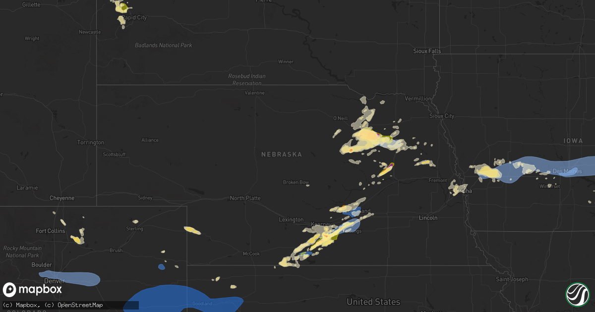
Hail Map in Nebraska on July 10, 2025
Get this storm
July 10 map
$229
one time, instant access
Download today. No call, no setup
Keep the $229
Bought the map and want the full workflow? Apply the entire $229 to a subscription within 7 days. None of it is wasted.
Every map, not just this one
This buys you this map. Subscription and you get every map we run, in the markets you choose from a few cities to whole states to nationwide. Plus real-time alerts the moment a storm fires.
Contact data
Name, contact info, occupancy, even credit band for addresses in the footprint. You go from where it hit to who to call.
Become the source they trust
Unlimited branding weather history reports on demand. You already have the documented answer ready for the property owner, and you are the one who showed up with it.
Property data and RoofTrace estimates
Pull up any address you have got, its value and the exact code rules for that jurisdiction, straight from One Click Code. Then RoofTrace estimates the squares, pitch, and roof value, priced the way you price.
Storm reports in Nebraska
Nebraska
| Date | Description |
|---|---|
| 07/10/20256:56 PM CDT | Mesonet site hayln1. Supported by radar data of a potential microburst in this area. |
| 07/10/20256:55 PM CDT | Image from social media of snapped power poles. |
| 07/10/20256:55 PM CDT | 8-10 inch in diameter tree branch limbs down. |
| 07/10/20256:51 PM CDT | Mesonet hayln1. |
| 07/10/20256:50 PM CDT | Social media report of several turned pivots as well as damage to a nearby grain silo. |
| 07/10/20256:37 PM CDT | Tree blown over onto house just south of the high school. Time estimated from radar and nearby mesonet reports. |
| 07/10/20256:37 PM CDT | Social media report of quarters with a few goofball sized hail in town. |
| 07/10/20256:35 PM CDT | Via davis weather station. |
| 07/10/20256:29 PM CDT | Via davis weather station. |
| 07/10/20256:27 PM CDT | Via davis weather station. |
| 07/10/20256:22 PM CDT | Ping pong to golf ball size hail at its peak caused damage to siding. |
| 07/10/20256:20 PM CDT | A local report indicates 1.00 inch wind near Wilcox |
| 07/10/20256:18 PM CDT | Report from mping: quarter |
| 07/10/20256:18 PM CDT | Report from mping: quarter . (o |
| 07/10/20256:17 PM CDT | Report from mping: quarter |
| 07/10/20256:17 PM CDT | A local report indicates 62 MPH wind near Grand Island Airport |
| 07/10/20256:15 PM CDT | Reports of structural damage and several reports of tree damage around town... Primarily on the north side of town. |
| 07/10/20256:15 PM CDT | A local report indicates 1.00 inch wind near Wilcox |
| 07/10/20256:04 PM CDT | Video of approximately 18 inch diameter tree limb down. Time estimated from radar. |
| 07/10/20255:58 PM CDT | Report from mping: half dollar |
| 07/10/20255:57 PM CDT | Report from mping: half dollar |
| 07/10/20255:40 PM CDT | A local report indicates 1.75 inch wind near 4 NE Neligh |
| 07/10/20254:45 PM CDT | Downed tree branches up to 7-8 inches in diameter. |
| 07/10/20253:35 PM CDT | A local report indicates 1.00 inch wind near 6 NNE Orleans |
| 07/10/20253:35 PM CDT | (g |
| 07/10/20253:27 PM CDT | Via davis weather station. |
| 07/09/20259:12 PM CDT | A few tree limbs down in town. |
| 07/09/20259:12 PM CDT | A few tree limbs down in town. (gi |
| 07/09/20258:54 PM CDT | Via personal weather station. |
| 07/09/20258:25 PM CDT | Report of 18 inch in diameter tree branch down. |
| 07/09/20258:20 PM CDT | A local report indicates 58 MPH wind near Holdrege Airport |
| 07/09/20257:50 PM CDT | A local report indicates 62 MPH wind near 1 N Oxford |
| 07/09/20257:50 PM CDT | A local report indicates 1.00 inch wind near Wilcox |
| 07/09/20257:45 PM CDT | Personal weather station. |
| 07/09/20257:36 PM CDT | A local report indicates 60 MPH wind near 2 NNE Hampton |
| 07/09/20257:23 PM CDT | A local report indicates 58 MPH wind near 1 SSE Aurora |
| 07/09/20257:14 PM CDT | A local report indicates 60 MPH wind near 2 W Aurora |
| 07/09/20257:12 PM CDT | Peak gust of 63 mph measured by asos. |
| 07/09/20257:12 PM CDT | Off duty nws employee reporting 50-60 mph wind gust. |
| 07/09/20257:08 PM CDT | Report from mping: quarter |
| 07/09/20257:04 PM CDT | A local report indicates 58 MPH wind near 5 WSW Hansen |
All States Impacted by Hail Map on July 10, 2025
Cities Impacted by Hail Map on July 10, 2025
- Brainerd, MN
- Newell, SD
- Vale, SD
- Pierz, MN
- Spalding, NE
- Whitewood, SD
- Sturgis, SD
- Primrose, NE
- Deadwood, SD
- Lead, SD
- Albion, NE
- Nemo, SD
- Piedmont, SD
- Black Hawk, SD
- Rapid City, SD
- Keystone, SD
- Newman Grove, NE
- Lindsay, NE
- Wasta, SD
- Pueblo, CO
- Celina, TX
- Little Elm, TX
- Frisco, TX
- Mckinney, TX
- Prosper, TX
- Miami, FL
- Macon, GA
- Lizella, GA
- Tamassee, SC
- Sebring, FL
- Norfolk, NE
- Bristolville, OH
- Warren, OH
- Southington, OH
- West Farmington, OH
- Orleans, VT
- Hoskins, NE
- Stanton, NE
- Camden, NC
- Leavittsburg, OH
- Randolph, NE
- Castle Rock, CO
- Franktown, CO
- McIntyre, GA
- Milledgeville, GA
- Niobrara, NE
- Gay, GA
- Bloomfield, NE
- Soperton, GA
- Tarrytown, GA
- Saint Cloud, FL
- Kenansville, FL
- Greenville, GA
- Woodbury, GA
- Thomaston, GA
- Middlebury, VT
- Vergennes, VT
- Fellsmere, FL
- Glenwood, GA
- Ramah, CO
- Yatesville, GA
- New Haven, VT
- East Dublin, GA
- Ravenna, OH
- Saint Francisville, LA
- Jackson, LA
- Palm Bay, FL
- Golden, CO
- Arvada, CO
- Broomfield, CO
- Wheat Ridge, CO
- Deerfield, KS
- Holcomb, KS
- Vero Beach, FL
- Westminster, CO
- Denver, CO
- Aurora, CO
- Commerce City, CO
- Henderson, CO
- Dupont, CO
- Garden City, KS
- Oxford, NE
- Stamford, NE
- Simla, CO
- McRae Helena, GA
- Orleans, NE
- Bridport, VT
- Wagon Mound, NM
- Matheson, CO
- Ruth, MS
- Alamo, GA
- Lakin, KS
- Punta Gorda, FL
- Alma, NE
- Republican City, NE
- Dixon, IL
- Clinton, SC
- Kinards, SC
- Mount Morris, NY
- Nunda, NY
- Arcadia, FL
- Ulysses, KS
- Milan, GA
- Newton, GA
- Abbeville, GA
- Statesboro, GA
- Clayton, NM
- Rock Falls, IL
- Sterling, IL
- Port Wentworth, GA
- Rincon, GA
- Manns Harbor, NC
- Stumpy Point, NC
- Baconton, GA
- Whitmire, SC
- Naples, FL
- Rhine, GA
- Guyton, GA
- Dansville, NY
- Sublette, KS
- Satanta, KS
- Johnson, KS
- Pierceville, KS
- Ingalls, KS
- Franklin Grove, IL
- Orangeville, IL
- Rock City, IL
- Davis, IL
- Goodwell, OK
- Bloomingdale, GA
- Leary, GA
- Spartanburg, SC
- Springer, NM
- Watkins, CO
- Brighton, CO
- Bennett, CO
- Strasburg, CO
- Byers, CO
- Deer Trail, CO
- Rockford, IL
- Rockton, IL
- Ashburn, GA
- Amherst, CO
- Ashton, IL
- Rochelle, GA
- Danielsville, GA
- Commerce, GA
- Claxton, GA
- Gladstone, NM
- Boise City, OK
- Port Saint Lucie, FL
- Edgefield, SC
- Roscoe, IL
- Copeland, KS
- Cimarron, KS
- Dighton, KS
- Beeler, KS
- Jetmore, KS
- Des Moines, NM
- Clearwater, NE
- Champion, NE
- Keswick, IA
- Durand, IL
- Pecatonica, IL
- Parnell, IA
- Williamsburg, IA
- Royal, NE
- Ewing, NE
- Orchard, NE
- Grenville, NM
- Pierce, NE
- Rebecca, GA
- Pella, IA
- Holyoke, CO
- Otley, IA
- Mclean, NE
- Osmond, NE
- Genoa, CO
- Hugo, CO
- Arriba, CO
- Joes, CO
- Cope, CO
- Seibert, CO
- Vona, CO
- Flagler, CO
- Stratton, CO
- Dodge City, KS
- Loves Park, IL
- Machesney Park, IL
- Caledonia, IL
- Oxford, IA
- Wellman, IA
- Tifton, GA
- Fitzgerald, GA
- New Sharon, IA
- Green Pond, SC
- Ravenna, NE
- Shelton, NE
- Cairo, NE
- Meigs, GA
- Pelham, GA
- Orangeburg, SC
- Webster, IA
- Saint Matthews, SC
- Leighton, IA
- Hardeeville, SC
- Savannah, GA
- Russell, IA
- West Brooklyn, IL
- Salisbury, VT
- Cowpens, SC
- Chula, GA
- Neligh, NE
- Brunswick, NE
- Cohocton, NY
- Hornell, NY
- Chariton, IA
- Venango, NE
- Imperial, NE
- Brooklyn, IA
- Oskaloosa, IA
- South English, IA
- Harper, IA
- Ocilla, GA
- Winnebago, IL
- Shirland, IL
- Bluffton, SC
- Iowa City, IA
- Bethune, CO
- Burlington, CO
- Idalia, CO
- Kirk, CO
- Cuervo, NM
- Newkirk, NM
- Canandaigua, NY
- Fort Stewart, GA
- Richmond Hill, GA
- Sigourney, IA
- Hayesville, IA
- Norman Park, GA
- Kalona, IA
- Deep River, IA
- Victor, IA
- Guernsey, IA
- Melrose, IA
- Ellabell, GA
- North English, IA
- Saint Libory, NE
- Grand Island, NE
- Albia, IA
- Wood River, NE
- Hedrick, IA
- Little Mountain, SC
- Prosperity, SC
- Beacon, IA
- Las Vegas, NM
- Tiffin, IA
- Coralville, IA
- Garrett, WY
- Midway, GA
- Iliff, CO
- Sterling, CO
- Archer, NE
- Chapman, NE
- Central City, NE
- Ollie, IA
- Axson, GA
- Palmer, NE
- Carr, CO
- Nunn, CO
- Granite Canon, WY
- Cheyenne, WY
- Amboy, IL
- Oakdale, NE
- Tilden, NE
- Plainview, NE
- Kanorado, KS
- Saint Francis, KS
- Goodland, KS
- Creighton, NE
- Winnetoon, NE
- Monticello, IA
- Earlville, IL
- Genoa, IL
- Compton, IL
- Moravia, IA
- Garden Prairie, IL
- Belvidere, IL
- Poplar Grove, IL
- Capron, IL
- Kingston, IL
- What Cheer, IA
- Kirkland, IL
- Steward, IL
- Cherry Valley, IL
- Meadow Grove, NE
- Hampshire, IL
- Marengo, IL
- Huntley, IL
- Gilberts, IL
- Yuma, CO
- Eckley, CO
- Alda, NE
- Doniphan, NE
- Anamosa, IA
- Richland, IA
- Gill, CO
- Greeley, CO
- Paw Paw, IL
- Cascade, IA
- Dalhart, TX
- Petersburg, NE
- Briggsdale, CO
- Santa Rosa, NM
- Fort Sumner, NM
- Elgin, IL
- Battle Creek, NE
- Edson, KS
- Winona, KS
- Brewster, KS
- Colby, KS
- Elbert, CO
- Colorado Springs, CO
- Peyton, CO
- Calhan, CO
- Yoder, CO
- Rush, CO
- Verdigre, NE
- Platte Center, NE
- Felt, OK
- Moultrie, GA
- Toddville, IA
- Marion, IA
- Cedar Rapids, IA
- Monroe, NE
- Minooka, IL
- Central City, IA
- Coggon, IA
- Kersey, CO
- Eaton, CO
- Genoa, NE
- Humphrey, NE
- Unionville, IA
- Maxbass, ND
- Lone Tree, IA
- Mendota, IL
- Riverside, IA
- Wallace, KS
- Levant, KS
- Saint Edward, NE
- Naylor, GA
- Robins, IA
- Wilcox, NE
- Dyersville, IA
- New Vienna, IA
- Brighton, IA
- Fairfield, IA
- Westhope, ND
- Antler, ND
- Fullerton, NE
- Baldwyn, MS
- Bloomfield, NY
- Townsend, GA
- Ludowici, GA
- Riceboro, GA
- Columbus Junction, IA
- Nichols, IA
- Conesville, IA
- Elgin, NE
- Packwood, IA
- Adams Run, SC
- Saratoga Springs, NY
- Phillips, NE
- Boone, CO
- Ordway, CO
- Channahon, IL
- Minden, NE
- Newburg, ND
- Funk, NE
- Axtell, NE
- Lockridge, IA
- Hildreth, NE
- Calamus, IA
- Wheatland, IA
- Grand Mound, IA
- Beloit, WI
- Page, NE
- Heartwell, NE
- Drakesville, IA
- Waycross, GA
- Wray, CO
- Wilmington, IL
- Farley, IA
- Kenesaw, NE
- Lovilia, IA
- Ravenel, SC
- Schuylerville, NY
- Stillwater, NY
- Lost Nation, IA
- Bernard, IA
- Hiawatha, IA
- Greenwich, NY
- Johnsonville, NY
- Valley Falls, NY
- Schaghticoke, NY
- Buskirk, NY
- Cambridge, NY
- Upham, ND
- Hollywood, SC
- Gibbon, NE
- Eddyville, IA
- Bartlett, NE
- Queensbury, NY
- Hudson Falls, NY
- Glens Falls, NY
- Fort Ann, NY
- Mohall, ND
- Kramer, ND
- Souris, ND
- McDonald, KS
- Hendley, NE
- Pierce, CO
- Bantry, ND
- Willow City, ND
- Drake, ND
- Johnson, VT
- Manteno, IL
- Barton, VT
- Irasburg, VT
- Thomson, IL
- Brunswick, GA
- Galeton, CO
- Teeds Grove, IA
- Sabula, IA
- Clinton, IA
- Naponee, NE
- Manhattan, IL
- Underhill, VT
- Stowe, VT
- Jeffersonville, VT
- Harvey, ND
- Martin, ND
- Anamoose, ND
- Savanna, IL
- Ottumwa, IA
- Bird City, KS
- Juniata, NE
- Hastings, NE
- Atwood, KS
- Bryant, IA
- Mount Carroll, IL
- Wilsonville, NE
- Homerville, GA
- Bourbonnais, IL
- Goose Lake, IA
- Manor, GA
- Fulton, IL
- Norton, KS
- Beaver City, NE
- Morrison, IL
- De Witt, IA
- Chadwick, IL
- Kankakee, IL
- Preston, IA
- Guntown, MS
- Mantachie, MS
- Bellevue, IA
- Bradley, IL
- Silver Creek, NE
- Giltner, NE
- Almena, KS
- Holdrege, NE
- Atlanta, NE
- Onslow, IA
- Center Junction, IA
- Aurora, NE
- Saint Anne, IL
- Raleigh, NC
- Blue Springs, MS
- Ecru, MS
- Lowden, IA
- Oregon, IL
- Mount Morris, IL
- Dixon, IA
- Pender, NE
- Bancroft, NE
- Polo, IL
- Bennett, IA
- Wilton, IA
- Lyndon, IL
- Chana, IL
- Hampton, NE
- Momence, IL
- Gem, KS
- Rexford, KS
- Monument, KS
- Tampico, IL
- Durant, IA
- Stockton, IA
- Chambers, NE
- Prophetstown, IL
- Madison, NE
- Walcott, IA
- New Liberty, IA
- Kearney, NE
- Harmon, IL
- Wisner, NE
- Springfield, SD
- Miles, IA
- Spragueville, IA
- Pembroke Township, IL
- Deer Grove, IL
- Albany, IL
- Camanche, IA
- Fenton, IL
- Low Moor, IA
- Long Island, KS
- Charlotte, IA
- Wagner, SD
- Knoxville, IA
- Harvey, IA
- Lake Placid, NY
- Bloomingdale, NY
- Wayne, NE
- Walnut, IL
- Sheffield, IL
- Grover, CO
- Pilger, NE
- Esmond, IL
- Manlius, IL
- Princeton, IL
- Wyanet, IL
- Logan, IA
- Milledgeville, IL
- Milan, IL
- Rock Island, IL
- Eagle Bridge, NY
- Long Grove, IA
- Neeses, SC
- Clifton, IL
- Portsmouth, IA
- Persia, IA
- Aledo, IL
- Sherrard, IL
- Coal Valley, IL
- Orion, IL
- McCausland, IA
- Irwin, IA
- Kirkman, IA
- Shelby, IA
- New Windsor, IL
- Lynn Center, IL
- Sheridan, IL
- Harlan, IA
- Panama, IA
- Neola, IA
- Minden, IA
- Atkinson, IL
- Kewanee, IL
- Audubon, IA
- Hoisington, KS
- Elm Creek, NE
- Saranac Lake, NY
- Alpha, IL
- Avoca, IA
- Manning, IA
- Loomis, NE
- Ansley, NE
- Dodge, NE
- Omaha, NE
- West Point, NE
- Scribner, NE
- Douglas, WY
- Howells, NE
- Elk Horn, IA
- Marne, IA
- Walnut, IA
- Cameron, SC
- Bunker Hill, KS
- Bennington, NE
- Elkhorn, NE
- Boys Town, NE
- Bennettsville, SC
- Atlantic, IA
- Wiota, IA
- Brayton, IA
- Exira, IA
- Anita, IA
- Adair, IA
- Kimballton, IA
- Hamlin, IA
- Guthrie Center, IA
- Coon Rapids, IA
- Bayard, IA
- Lance Creek, WY
- Keene, NY
- La Vista, NE
- Letts, IA
- Snyder, NE
- Casey, IA
- Hooper, NE
- Pritchett, CO
- Woodbine, IA
- Upland, NE
- Hancock, IA
- Crescent, IA
- Kenton, OK
- Menlo, IA
- Stuart, IA
- Moline, IL
- Beemer, NE
- Panora, IA
- Lusk, WY
- Missouri Valley, IA
- Shawnee, WY
- Lost Springs, WY
- Redfield, IA
- Davenport, IA
- Ainsworth, IA
- Washington, IA
- Norcatur, KS
- Earlham, IA
- Delmar, IA
- Adel, IA
- Keota, IA
- Carter Lake, IA
- Council Bluffs, IA
- Manville, WY
- West Chester, IA
- Winterset, IA
- Tupelo, MS
- Linden, IA
- Bagley, IA
- Yale, IA
- Minburn, IA
- Perry, IA
- Jamaica, IA
- Dawson, IA
- Dallas Center, IA
- Van Meter, IA
- De Soto, IA
- Waukee, IA
- Des Moines, IA
- Grimes, IA
- Clive, IA
- West Des Moines, IA
- Urbandale, IA
- Cumming, IA
- Norwalk, IA
- Elkhart, IA
- Granger, IA
- Johnston, IA
- Altoona, IA
- Ankeny, IA
- Polk City, IA
- Woodward, IA
- Bondurant, IA
- Windsor Heights, IA
- Berwick, IA
- Dexter, IA
- Prole, IA
- Pleasant Hill, IA
- Mitchellville, IA
- Carlisle, IA
- Prairie City, IA
- Runnells, IA
- Trumbull, NE
- Dorrance, KS
- Holstein, NE
- Monroe, IA
- Colfax, IA
- Mingo, IA
- Baxter, IA
- Maxwell, IA
- Ira, IA
- Newton, IA
- Boston, GA
- Pavo, GA
- Dixie, GA
- Kennard, NE
- Tillman, SC
- Pembroke, GA
- Fleming, GA
- Blair, NE
- Fort Calhoun, NE
- New Bedford, IL
- Montezuma, IA
- Ladora, IA
- Killduff, IA
- Reasnor, IA
- Sully, IA
- Kellogg, IA
- Lynnville, IA
- Searsboro, IA
- Grinnell, IA
- Malcom, IA
- Laurel, IA
- Gilman, IA
- Millersburg, IA
- Conroy, IA
- Hartwick, IA
- Marengo, IA
- Chelsea, IA
- Belle Plaine, IA
- South Amana, IA
- Homestead, IA
- Middle Amana, IA
- Amana, IA
- Fairfax, IA
- Solon, IA
- North Liberty, IA
- Swisher, IA
- Hills, IA
- Center Conway, NH
- Lovell, ME
- West Branch, IA
- West Liberty, IA
- Stoneham, ME
- Tipton, IA
- Keyes, OK
- Bethel, ME
- Guildhall, VT
- Mechanicsville, IA
- Holly, CO
- Syracuse, KS
- Coolidge, KS
- Kendall, KS
- Marienthal, KS
- Scott City, KS
- Leoti, KS
- Norway, ME
- North Stratford, NH
- Healy, KS
- South Paris, ME
- Hebron, ME
- Taiban, NM
- Minot, ME
- Turner, ME


