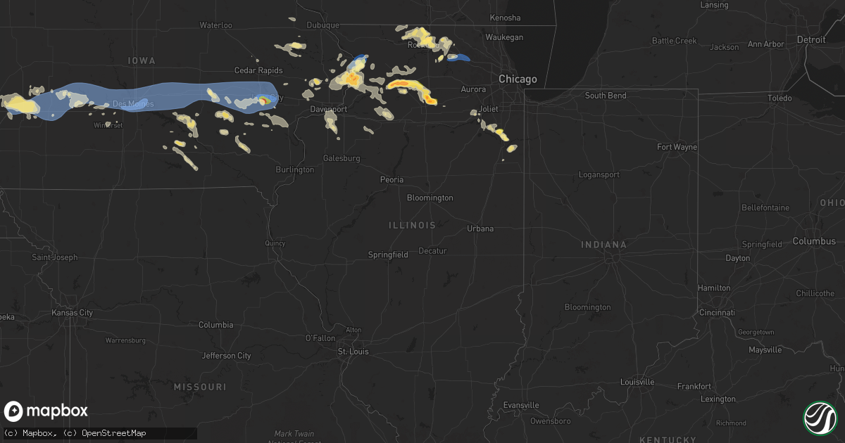
Hail Map in Illinois on July 10, 2025
Get this storm
July 10 map
$229
one time, instant access
Download today. No call, no setup
Keep the $229
Bought the map and want the full workflow? Apply the entire $229 to a subscription within 7 days. None of it is wasted.
Every map, not just this one
This buys you this map. Subscription and you get every map we run, in the markets you choose from a few cities to whole states to nationwide. Plus real-time alerts the moment a storm fires.
Contact data
Name, contact info, occupancy, even credit band for addresses in the footprint. You go from where it hit to who to call.
Become the source they trust
Unlimited branding weather history reports on demand. You already have the documented answer ready for the property owner, and you are the one who showed up with it.
Property data and RoofTrace estimates
Pull up any address you have got, its value and the exact code rules for that jurisdiction, straight from One Click Code. Then RoofTrace estimates the squares, pitch, and roof value, priced the way you price.
Storm reports in Illinois
Illinois
| Date | Description |
|---|---|
| 07/10/20256:03 PM CDT | Large branch of a bradford pear tree snapped. Time estimated by radar. |
| 07/10/20255:55 PM CDT | 6 inch tree limb downed on dietrich road in hampshire. Time estimated via radar. |
| 07/10/20255:55 PM CDT | Downed power lines resulting in power outages in the 100 block of terwilliger avenue. Time estimated by radar. |
| 07/10/20255:42 PM CDT | A local report indicates 2.00 inch wind near 4 NW Earlville |
| 07/10/20255:27 PM CDT | Report from mping: quarter |
| 07/10/20255:20 PM CDT | Multiple trees and power lines downed in cherry valley and on the southeast side of rockford. Time estimated from radar. |
| 07/10/20255:13 PM CDT | A local report indicates 1.00 inch wind near 4 NNW Cherry Valley |
| 07/10/20255:10 PM CDT | A local report indicates 1.50 inch wind near Machesney Park |
| 07/10/20255:10 PM CDT | Report from mping: quarter |
| 07/10/20255:05 PM CDT | Heavy hail from 5:00-5:10 pm. Varied in size with largest piece being 1.5in measured. No injuries and no obvious damage at this time. |
| 07/10/20254:56 PM CDT | Up to 6 diameter limbs down near brooklyn rd on rt 30. Corn fields also have corn blown at 35 to 40 degree angles. |
| 07/10/20254:55 PM CDT | Report from mping: quarter |
| 07/10/20254:47 PM CDT | Time estimated by radar. |
| 07/10/20254:27 PM CDT | Report from mping: hen egg |
| 07/10/20254:17 PM CDT | Report from mping: hen egg |
| 07/10/20254:14 PM CDT | Report from mping: half dollar |
| 07/10/20254:07 PM CDT | Report from mping: ping pong ball |
| 07/10/20253:56 PM CDT | A local report indicates 1.50 inch wind near 1 ESE Dixon |
| 07/10/20253:33 PM CDT | A local report indicates 1.25 inch wind near 2 N Nelson |
| 07/10/20253:28 PM CDT | A local report indicates 1.75 inch wind near 2 NE Nelson |
| 07/10/20257:35 AM CDT | Corrects previous tstm wnd dmg report from manteno |
| 07/09/202510:53 PM CDT | Depue fire reported trees and limbs down throughout town... Some of which were blocking roadways. They also reported minor flooding. Time estimated by radar. |
| 07/09/202510:20 PM CDT | Media in kewanee relayed a henry county sheriffs office report of a tree down on county highway 5 north of highway 81. Time estimated by radar. |
| 07/09/20258:11 PM CDT | Mping report of half dollar sized hail. |
| 07/09/20257:52 PM CDT | Measured at a personal weather station on the northwest side of manteno. |
| 07/09/20257:40 PM CDT | Report of a lot of trees down throughout this area. |
| 07/09/20257:40 PM CDT | Quarter sized hail lasting for about ten minutes. |
| 07/09/20257:40 PM CDT | Report of a lot of trees down throughout th |
| 07/09/20257:40 PM CDT | Quarter sized hail lasting for about ten minutes |
| 07/09/20257:35 PM CDT | 5 downed power poles at 9000n and 3250w west of manteno. |
| 07/09/20257:35 PM CDT | Reports of several downed power lines |
| 07/09/20257:35 PM CDT | Corrects previous tstm wnd dmg report from 7 se symerton. Corrects previous tstm wnd dmg report from manteno |
| 07/09/20257:30 PM CDT | Report of numerous power lines down... Power poles snapped... And trees down across roads. This damage is widespread throughout the area. |
| 07/09/20257:25 PM CDT | A local report indicates 1.25 inch wind near 1 ESE Savanna |
| 07/09/20257:20 PM CDT | 70 foot repeater tower knocked down due to high winds. |
| 07/09/20257:12 PM CDT | Dispatch reported multiple power poles and wires down... Leading to portions of route 84 being closed. Along the same route... Reports of several farm irrigators being |
All States Impacted by Hail Map on July 10, 2025
Cities Impacted by Hail Map on July 10, 2025
- Brainerd, MN
- Newell, SD
- Vale, SD
- Pierz, MN
- Spalding, NE
- Whitewood, SD
- Sturgis, SD
- Primrose, NE
- Deadwood, SD
- Lead, SD
- Albion, NE
- Nemo, SD
- Piedmont, SD
- Black Hawk, SD
- Rapid City, SD
- Keystone, SD
- Newman Grove, NE
- Lindsay, NE
- Wasta, SD
- Pueblo, CO
- Celina, TX
- Little Elm, TX
- Frisco, TX
- Mckinney, TX
- Prosper, TX
- Miami, FL
- Macon, GA
- Lizella, GA
- Tamassee, SC
- Sebring, FL
- Norfolk, NE
- Bristolville, OH
- Warren, OH
- Southington, OH
- West Farmington, OH
- Orleans, VT
- Hoskins, NE
- Stanton, NE
- Camden, NC
- Leavittsburg, OH
- Randolph, NE
- Castle Rock, CO
- Franktown, CO
- McIntyre, GA
- Milledgeville, GA
- Niobrara, NE
- Gay, GA
- Bloomfield, NE
- Soperton, GA
- Tarrytown, GA
- Saint Cloud, FL
- Kenansville, FL
- Greenville, GA
- Woodbury, GA
- Thomaston, GA
- Middlebury, VT
- Vergennes, VT
- Fellsmere, FL
- Glenwood, GA
- Ramah, CO
- Yatesville, GA
- New Haven, VT
- East Dublin, GA
- Ravenna, OH
- Saint Francisville, LA
- Jackson, LA
- Palm Bay, FL
- Golden, CO
- Arvada, CO
- Broomfield, CO
- Wheat Ridge, CO
- Deerfield, KS
- Holcomb, KS
- Vero Beach, FL
- Westminster, CO
- Denver, CO
- Aurora, CO
- Commerce City, CO
- Henderson, CO
- Dupont, CO
- Garden City, KS
- Oxford, NE
- Stamford, NE
- Simla, CO
- McRae Helena, GA
- Orleans, NE
- Bridport, VT
- Wagon Mound, NM
- Matheson, CO
- Ruth, MS
- Alamo, GA
- Lakin, KS
- Punta Gorda, FL
- Alma, NE
- Republican City, NE
- Dixon, IL
- Clinton, SC
- Kinards, SC
- Mount Morris, NY
- Nunda, NY
- Arcadia, FL
- Ulysses, KS
- Milan, GA
- Newton, GA
- Abbeville, GA
- Statesboro, GA
- Clayton, NM
- Rock Falls, IL
- Sterling, IL
- Port Wentworth, GA
- Rincon, GA
- Manns Harbor, NC
- Stumpy Point, NC
- Baconton, GA
- Whitmire, SC
- Naples, FL
- Rhine, GA
- Guyton, GA
- Dansville, NY
- Sublette, KS
- Satanta, KS
- Johnson, KS
- Pierceville, KS
- Ingalls, KS
- Franklin Grove, IL
- Orangeville, IL
- Rock City, IL
- Davis, IL
- Goodwell, OK
- Bloomingdale, GA
- Leary, GA
- Spartanburg, SC
- Springer, NM
- Watkins, CO
- Brighton, CO
- Bennett, CO
- Strasburg, CO
- Byers, CO
- Deer Trail, CO
- Rockford, IL
- Rockton, IL
- Ashburn, GA
- Amherst, CO
- Ashton, IL
- Rochelle, GA
- Danielsville, GA
- Commerce, GA
- Claxton, GA
- Gladstone, NM
- Boise City, OK
- Port Saint Lucie, FL
- Edgefield, SC
- Roscoe, IL
- Copeland, KS
- Cimarron, KS
- Dighton, KS
- Beeler, KS
- Jetmore, KS
- Des Moines, NM
- Clearwater, NE
- Champion, NE
- Keswick, IA
- Durand, IL
- Pecatonica, IL
- Parnell, IA
- Williamsburg, IA
- Royal, NE
- Ewing, NE
- Orchard, NE
- Grenville, NM
- Pierce, NE
- Rebecca, GA
- Pella, IA
- Holyoke, CO
- Otley, IA
- Mclean, NE
- Osmond, NE
- Genoa, CO
- Hugo, CO
- Arriba, CO
- Joes, CO
- Cope, CO
- Seibert, CO
- Vona, CO
- Flagler, CO
- Stratton, CO
- Dodge City, KS
- Loves Park, IL
- Machesney Park, IL
- Caledonia, IL
- Oxford, IA
- Wellman, IA
- Tifton, GA
- Fitzgerald, GA
- New Sharon, IA
- Green Pond, SC
- Ravenna, NE
- Shelton, NE
- Cairo, NE
- Meigs, GA
- Pelham, GA
- Orangeburg, SC
- Webster, IA
- Saint Matthews, SC
- Leighton, IA
- Hardeeville, SC
- Savannah, GA
- Russell, IA
- West Brooklyn, IL
- Salisbury, VT
- Cowpens, SC
- Chula, GA
- Neligh, NE
- Brunswick, NE
- Cohocton, NY
- Hornell, NY
- Chariton, IA
- Venango, NE
- Imperial, NE
- Brooklyn, IA
- Oskaloosa, IA
- South English, IA
- Harper, IA
- Ocilla, GA
- Winnebago, IL
- Shirland, IL
- Bluffton, SC
- Iowa City, IA
- Bethune, CO
- Burlington, CO
- Idalia, CO
- Kirk, CO
- Cuervo, NM
- Newkirk, NM
- Canandaigua, NY
- Fort Stewart, GA
- Richmond Hill, GA
- Sigourney, IA
- Hayesville, IA
- Norman Park, GA
- Kalona, IA
- Deep River, IA
- Victor, IA
- Guernsey, IA
- Melrose, IA
- Ellabell, GA
- North English, IA
- Saint Libory, NE
- Grand Island, NE
- Albia, IA
- Wood River, NE
- Hedrick, IA
- Little Mountain, SC
- Prosperity, SC
- Beacon, IA
- Las Vegas, NM
- Tiffin, IA
- Coralville, IA
- Garrett, WY
- Midway, GA
- Iliff, CO
- Sterling, CO
- Archer, NE
- Chapman, NE
- Central City, NE
- Ollie, IA
- Axson, GA
- Palmer, NE
- Carr, CO
- Nunn, CO
- Granite Canon, WY
- Cheyenne, WY
- Amboy, IL
- Oakdale, NE
- Tilden, NE
- Plainview, NE
- Kanorado, KS
- Saint Francis, KS
- Goodland, KS
- Creighton, NE
- Winnetoon, NE
- Monticello, IA
- Earlville, IL
- Genoa, IL
- Compton, IL
- Moravia, IA
- Garden Prairie, IL
- Belvidere, IL
- Poplar Grove, IL
- Capron, IL
- Kingston, IL
- What Cheer, IA
- Kirkland, IL
- Steward, IL
- Cherry Valley, IL
- Meadow Grove, NE
- Hampshire, IL
- Marengo, IL
- Huntley, IL
- Gilberts, IL
- Yuma, CO
- Eckley, CO
- Alda, NE
- Doniphan, NE
- Anamosa, IA
- Richland, IA
- Gill, CO
- Greeley, CO
- Paw Paw, IL
- Cascade, IA
- Dalhart, TX
- Petersburg, NE
- Briggsdale, CO
- Santa Rosa, NM
- Fort Sumner, NM
- Elgin, IL
- Battle Creek, NE
- Edson, KS
- Winona, KS
- Brewster, KS
- Colby, KS
- Elbert, CO
- Colorado Springs, CO
- Peyton, CO
- Calhan, CO
- Yoder, CO
- Rush, CO
- Verdigre, NE
- Platte Center, NE
- Felt, OK
- Moultrie, GA
- Toddville, IA
- Marion, IA
- Cedar Rapids, IA
- Monroe, NE
- Minooka, IL
- Central City, IA
- Coggon, IA
- Kersey, CO
- Eaton, CO
- Genoa, NE
- Humphrey, NE
- Unionville, IA
- Maxbass, ND
- Lone Tree, IA
- Mendota, IL
- Riverside, IA
- Wallace, KS
- Levant, KS
- Saint Edward, NE
- Naylor, GA
- Robins, IA
- Wilcox, NE
- Dyersville, IA
- New Vienna, IA
- Brighton, IA
- Fairfield, IA
- Westhope, ND
- Antler, ND
- Fullerton, NE
- Baldwyn, MS
- Bloomfield, NY
- Townsend, GA
- Ludowici, GA
- Riceboro, GA
- Columbus Junction, IA
- Nichols, IA
- Conesville, IA
- Elgin, NE
- Packwood, IA
- Adams Run, SC
- Saratoga Springs, NY
- Phillips, NE
- Boone, CO
- Ordway, CO
- Channahon, IL
- Minden, NE
- Newburg, ND
- Funk, NE
- Axtell, NE
- Lockridge, IA
- Hildreth, NE
- Calamus, IA
- Wheatland, IA
- Grand Mound, IA
- Beloit, WI
- Page, NE
- Heartwell, NE
- Drakesville, IA
- Waycross, GA
- Wray, CO
- Wilmington, IL
- Farley, IA
- Kenesaw, NE
- Lovilia, IA
- Ravenel, SC
- Schuylerville, NY
- Stillwater, NY
- Lost Nation, IA
- Bernard, IA
- Hiawatha, IA
- Greenwich, NY
- Johnsonville, NY
- Valley Falls, NY
- Schaghticoke, NY
- Buskirk, NY
- Cambridge, NY
- Upham, ND
- Hollywood, SC
- Gibbon, NE
- Eddyville, IA
- Bartlett, NE
- Queensbury, NY
- Hudson Falls, NY
- Glens Falls, NY
- Fort Ann, NY
- Mohall, ND
- Kramer, ND
- Souris, ND
- McDonald, KS
- Hendley, NE
- Pierce, CO
- Bantry, ND
- Willow City, ND
- Drake, ND
- Johnson, VT
- Manteno, IL
- Barton, VT
- Irasburg, VT
- Thomson, IL
- Brunswick, GA
- Galeton, CO
- Teeds Grove, IA
- Sabula, IA
- Clinton, IA
- Naponee, NE
- Manhattan, IL
- Underhill, VT
- Stowe, VT
- Jeffersonville, VT
- Harvey, ND
- Martin, ND
- Anamoose, ND
- Savanna, IL
- Ottumwa, IA
- Bird City, KS
- Juniata, NE
- Hastings, NE
- Atwood, KS
- Bryant, IA
- Mount Carroll, IL
- Wilsonville, NE
- Homerville, GA
- Bourbonnais, IL
- Goose Lake, IA
- Manor, GA
- Fulton, IL
- Norton, KS
- Beaver City, NE
- Morrison, IL
- De Witt, IA
- Chadwick, IL
- Kankakee, IL
- Preston, IA
- Guntown, MS
- Mantachie, MS
- Bellevue, IA
- Bradley, IL
- Silver Creek, NE
- Giltner, NE
- Almena, KS
- Holdrege, NE
- Atlanta, NE
- Onslow, IA
- Center Junction, IA
- Aurora, NE
- Saint Anne, IL
- Raleigh, NC
- Blue Springs, MS
- Ecru, MS
- Lowden, IA
- Oregon, IL
- Mount Morris, IL
- Dixon, IA
- Pender, NE
- Bancroft, NE
- Polo, IL
- Bennett, IA
- Wilton, IA
- Lyndon, IL
- Chana, IL
- Hampton, NE
- Momence, IL
- Gem, KS
- Rexford, KS
- Monument, KS
- Tampico, IL
- Durant, IA
- Stockton, IA
- Chambers, NE
- Prophetstown, IL
- Madison, NE
- Walcott, IA
- New Liberty, IA
- Kearney, NE
- Harmon, IL
- Wisner, NE
- Springfield, SD
- Miles, IA
- Spragueville, IA
- Pembroke Township, IL
- Deer Grove, IL
- Albany, IL
- Camanche, IA
- Fenton, IL
- Low Moor, IA
- Long Island, KS
- Charlotte, IA
- Wagner, SD
- Knoxville, IA
- Harvey, IA
- Lake Placid, NY
- Bloomingdale, NY
- Wayne, NE
- Walnut, IL
- Sheffield, IL
- Grover, CO
- Pilger, NE
- Esmond, IL
- Manlius, IL
- Princeton, IL
- Wyanet, IL
- Logan, IA
- Milledgeville, IL
- Milan, IL
- Rock Island, IL
- Eagle Bridge, NY
- Long Grove, IA
- Neeses, SC
- Clifton, IL
- Portsmouth, IA
- Persia, IA
- Aledo, IL
- Sherrard, IL
- Coal Valley, IL
- Orion, IL
- McCausland, IA
- Irwin, IA
- Kirkman, IA
- Shelby, IA
- New Windsor, IL
- Lynn Center, IL
- Sheridan, IL
- Harlan, IA
- Panama, IA
- Neola, IA
- Minden, IA
- Atkinson, IL
- Kewanee, IL
- Audubon, IA
- Hoisington, KS
- Elm Creek, NE
- Saranac Lake, NY
- Alpha, IL
- Avoca, IA
- Manning, IA
- Loomis, NE
- Ansley, NE
- Dodge, NE
- Omaha, NE
- West Point, NE
- Scribner, NE
- Douglas, WY
- Howells, NE
- Elk Horn, IA
- Marne, IA
- Walnut, IA
- Cameron, SC
- Bunker Hill, KS
- Bennington, NE
- Elkhorn, NE
- Boys Town, NE
- Bennettsville, SC
- Atlantic, IA
- Wiota, IA
- Brayton, IA
- Exira, IA
- Anita, IA
- Adair, IA
- Kimballton, IA
- Hamlin, IA
- Guthrie Center, IA
- Coon Rapids, IA
- Bayard, IA
- Lance Creek, WY
- Keene, NY
- La Vista, NE
- Letts, IA
- Snyder, NE
- Casey, IA
- Hooper, NE
- Pritchett, CO
- Woodbine, IA
- Upland, NE
- Hancock, IA
- Crescent, IA
- Kenton, OK
- Menlo, IA
- Stuart, IA
- Moline, IL
- Beemer, NE
- Panora, IA
- Lusk, WY
- Missouri Valley, IA
- Shawnee, WY
- Lost Springs, WY
- Redfield, IA
- Davenport, IA
- Ainsworth, IA
- Washington, IA
- Norcatur, KS
- Earlham, IA
- Delmar, IA
- Adel, IA
- Keota, IA
- Carter Lake, IA
- Council Bluffs, IA
- Manville, WY
- West Chester, IA
- Winterset, IA
- Tupelo, MS
- Linden, IA
- Bagley, IA
- Yale, IA
- Minburn, IA
- Perry, IA
- Jamaica, IA
- Dawson, IA
- Dallas Center, IA
- Van Meter, IA
- De Soto, IA
- Waukee, IA
- Des Moines, IA
- Grimes, IA
- Clive, IA
- West Des Moines, IA
- Urbandale, IA
- Cumming, IA
- Norwalk, IA
- Elkhart, IA
- Granger, IA
- Johnston, IA
- Altoona, IA
- Ankeny, IA
- Polk City, IA
- Woodward, IA
- Bondurant, IA
- Windsor Heights, IA
- Berwick, IA
- Dexter, IA
- Prole, IA
- Pleasant Hill, IA
- Mitchellville, IA
- Carlisle, IA
- Prairie City, IA
- Runnells, IA
- Trumbull, NE
- Dorrance, KS
- Holstein, NE
- Monroe, IA
- Colfax, IA
- Mingo, IA
- Baxter, IA
- Maxwell, IA
- Ira, IA
- Newton, IA
- Boston, GA
- Pavo, GA
- Dixie, GA
- Kennard, NE
- Tillman, SC
- Pembroke, GA
- Fleming, GA
- Blair, NE
- Fort Calhoun, NE
- New Bedford, IL
- Montezuma, IA
- Ladora, IA
- Killduff, IA
- Reasnor, IA
- Sully, IA
- Kellogg, IA
- Lynnville, IA
- Searsboro, IA
- Grinnell, IA
- Malcom, IA
- Laurel, IA
- Gilman, IA
- Millersburg, IA
- Conroy, IA
- Hartwick, IA
- Marengo, IA
- Chelsea, IA
- Belle Plaine, IA
- South Amana, IA
- Homestead, IA
- Middle Amana, IA
- Amana, IA
- Fairfax, IA
- Solon, IA
- North Liberty, IA
- Swisher, IA
- Hills, IA
- Center Conway, NH
- Lovell, ME
- West Branch, IA
- West Liberty, IA
- Stoneham, ME
- Tipton, IA
- Keyes, OK
- Bethel, ME
- Guildhall, VT
- Mechanicsville, IA
- Holly, CO
- Syracuse, KS
- Coolidge, KS
- Kendall, KS
- Marienthal, KS
- Scott City, KS
- Leoti, KS
- Norway, ME
- North Stratford, NH
- Healy, KS
- South Paris, ME
- Hebron, ME
- Taiban, NM
- Minot, ME
- Turner, ME


