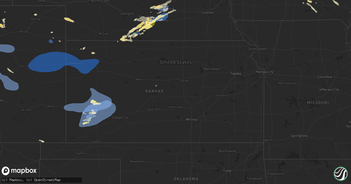
Hail Map in Kansas on July 10, 2025
Get this storm
July 10 map
$229
one time, instant access
Download today. No call, no setup
Keep the $229
Bought the map and want the full workflow? Apply the entire $229 to a subscription within 7 days. None of it is wasted.
Every map, not just this one
This buys you this map. Subscription and you get every map we run, in the markets you choose from a few cities to whole states to nationwide. Plus real-time alerts the moment a storm fires.
Contact data
Name, contact info, occupancy, even credit band for addresses in the footprint. You go from where it hit to who to call.
Become the source they trust
Unlimited branding weather history reports on demand. You already have the documented answer ready for the property owner, and you are the one who showed up with it.
Property data and RoofTrace estimates
Pull up any address you have got, its value and the exact code rules for that jurisdiction, straight from One Click Code. Then RoofTrace estimates the squares, pitch, and roof value, priced the way you price.
Storm reports in Kansas
Kansas
| Date | Description |
|---|---|
| 07/10/20256:57 PM CDT | Social media report of wind gusts up to 70 mph. |
| 07/10/20256:41 PM CDT | Mesonet station up840 9.0 w winona |
| 07/10/20254:03 PM CDT | A local report indicates 83 MPH wind near 1 SW Garden City |
| 07/10/20253:57 PM CDT | A local report indicates 60 MPH wind near 2 ENE Garden City |
| 07/10/20253:35 PM CDT | Awos station kuls ulysses. |
| 07/10/20253:33 PM CDT | A local report indicates 1.00 inch wind near Ulysses |
| 07/10/20253:05 PM CDT | A local report indicates 1.00 inch wind near 6 WNW Friend |
| 07/09/20258:10 PM CDT | Ambient weather network site videra_weather. |
| 07/09/20258:01 PM CDT | A local report indicates 67 MPH wind near 2 E Shallow Water |
| 07/09/20257:55 PM CDT | Awos station k36k 2 n lakin. |
| 07/09/20257:55 PM CDT | Awos station kjhn johnson city. |
| 07/09/20257:47 PM CDT | Site landfill office measure 58 mph wind gust. |
| 07/09/20257:39 PM CDT | Personal weather station kkslakin28. |
| 07/09/20257:38 PM CDT | Ambient weather network site nwkecounty. |
| 07/09/20257:31 PM CDT | Mesonet d5288. |
| 07/09/20257:30 PM CDT | A local report indicates 61 MPH wind near 1 ESE Kendall |
| 07/09/20257:18 PM CDT | Media storm chaser is reporting gusts of 50 to 60 mph. |
| 07/09/20257:15 PM CDT | Mesonet k5coo. |
| 07/09/20257:15 PM CDT | Awos station k3k3 syracuse. |
| 07/09/20257:09 PM CDT | Report from mesonet station. |
All States Impacted by Hail Map on July 10, 2025
Cities Impacted by Hail Map on July 10, 2025
- Brainerd, MN
- Newell, SD
- Vale, SD
- Pierz, MN
- Spalding, NE
- Whitewood, SD
- Sturgis, SD
- Primrose, NE
- Deadwood, SD
- Lead, SD
- Albion, NE
- Nemo, SD
- Piedmont, SD
- Black Hawk, SD
- Rapid City, SD
- Keystone, SD
- Newman Grove, NE
- Lindsay, NE
- Wasta, SD
- Pueblo, CO
- Celina, TX
- Little Elm, TX
- Frisco, TX
- Mckinney, TX
- Prosper, TX
- Miami, FL
- Macon, GA
- Lizella, GA
- Tamassee, SC
- Sebring, FL
- Norfolk, NE
- Bristolville, OH
- Warren, OH
- Southington, OH
- West Farmington, OH
- Orleans, VT
- Hoskins, NE
- Stanton, NE
- Camden, NC
- Leavittsburg, OH
- Randolph, NE
- Castle Rock, CO
- Franktown, CO
- McIntyre, GA
- Milledgeville, GA
- Niobrara, NE
- Gay, GA
- Bloomfield, NE
- Soperton, GA
- Tarrytown, GA
- Saint Cloud, FL
- Kenansville, FL
- Greenville, GA
- Woodbury, GA
- Thomaston, GA
- Middlebury, VT
- Vergennes, VT
- Fellsmere, FL
- Glenwood, GA
- Ramah, CO
- Yatesville, GA
- New Haven, VT
- East Dublin, GA
- Ravenna, OH
- Saint Francisville, LA
- Jackson, LA
- Palm Bay, FL
- Golden, CO
- Arvada, CO
- Broomfield, CO
- Wheat Ridge, CO
- Deerfield, KS
- Holcomb, KS
- Vero Beach, FL
- Westminster, CO
- Denver, CO
- Aurora, CO
- Commerce City, CO
- Henderson, CO
- Dupont, CO
- Garden City, KS
- Oxford, NE
- Stamford, NE
- Simla, CO
- McRae Helena, GA
- Orleans, NE
- Bridport, VT
- Wagon Mound, NM
- Matheson, CO
- Ruth, MS
- Alamo, GA
- Lakin, KS
- Punta Gorda, FL
- Alma, NE
- Republican City, NE
- Dixon, IL
- Clinton, SC
- Kinards, SC
- Mount Morris, NY
- Nunda, NY
- Arcadia, FL
- Ulysses, KS
- Milan, GA
- Newton, GA
- Abbeville, GA
- Statesboro, GA
- Clayton, NM
- Rock Falls, IL
- Sterling, IL
- Port Wentworth, GA
- Rincon, GA
- Manns Harbor, NC
- Stumpy Point, NC
- Baconton, GA
- Whitmire, SC
- Naples, FL
- Rhine, GA
- Guyton, GA
- Dansville, NY
- Sublette, KS
- Satanta, KS
- Johnson, KS
- Pierceville, KS
- Ingalls, KS
- Franklin Grove, IL
- Orangeville, IL
- Rock City, IL
- Davis, IL
- Goodwell, OK
- Bloomingdale, GA
- Leary, GA
- Spartanburg, SC
- Springer, NM
- Watkins, CO
- Brighton, CO
- Bennett, CO
- Strasburg, CO
- Byers, CO
- Deer Trail, CO
- Rockford, IL
- Rockton, IL
- Ashburn, GA
- Amherst, CO
- Ashton, IL
- Rochelle, GA
- Danielsville, GA
- Commerce, GA
- Claxton, GA
- Gladstone, NM
- Boise City, OK
- Port Saint Lucie, FL
- Edgefield, SC
- Roscoe, IL
- Copeland, KS
- Cimarron, KS
- Dighton, KS
- Beeler, KS
- Jetmore, KS
- Des Moines, NM
- Clearwater, NE
- Champion, NE
- Keswick, IA
- Durand, IL
- Pecatonica, IL
- Parnell, IA
- Williamsburg, IA
- Royal, NE
- Ewing, NE
- Orchard, NE
- Grenville, NM
- Pierce, NE
- Rebecca, GA
- Pella, IA
- Holyoke, CO
- Otley, IA
- Mclean, NE
- Osmond, NE
- Genoa, CO
- Hugo, CO
- Arriba, CO
- Joes, CO
- Cope, CO
- Seibert, CO
- Vona, CO
- Flagler, CO
- Stratton, CO
- Dodge City, KS
- Loves Park, IL
- Machesney Park, IL
- Caledonia, IL
- Oxford, IA
- Wellman, IA
- Tifton, GA
- Fitzgerald, GA
- New Sharon, IA
- Green Pond, SC
- Ravenna, NE
- Shelton, NE
- Cairo, NE
- Meigs, GA
- Pelham, GA
- Orangeburg, SC
- Webster, IA
- Saint Matthews, SC
- Leighton, IA
- Hardeeville, SC
- Savannah, GA
- Russell, IA
- West Brooklyn, IL
- Salisbury, VT
- Cowpens, SC
- Chula, GA
- Neligh, NE
- Brunswick, NE
- Cohocton, NY
- Hornell, NY
- Chariton, IA
- Venango, NE
- Imperial, NE
- Brooklyn, IA
- Oskaloosa, IA
- South English, IA
- Harper, IA
- Ocilla, GA
- Winnebago, IL
- Shirland, IL
- Bluffton, SC
- Iowa City, IA
- Bethune, CO
- Burlington, CO
- Idalia, CO
- Kirk, CO
- Cuervo, NM
- Newkirk, NM
- Canandaigua, NY
- Fort Stewart, GA
- Richmond Hill, GA
- Sigourney, IA
- Hayesville, IA
- Norman Park, GA
- Kalona, IA
- Deep River, IA
- Victor, IA
- Guernsey, IA
- Melrose, IA
- Ellabell, GA
- North English, IA
- Saint Libory, NE
- Grand Island, NE
- Albia, IA
- Wood River, NE
- Hedrick, IA
- Little Mountain, SC
- Prosperity, SC
- Beacon, IA
- Las Vegas, NM
- Tiffin, IA
- Coralville, IA
- Garrett, WY
- Midway, GA
- Iliff, CO
- Sterling, CO
- Archer, NE
- Chapman, NE
- Central City, NE
- Ollie, IA
- Axson, GA
- Palmer, NE
- Carr, CO
- Nunn, CO
- Granite Canon, WY
- Cheyenne, WY
- Amboy, IL
- Oakdale, NE
- Tilden, NE
- Plainview, NE
- Kanorado, KS
- Saint Francis, KS
- Goodland, KS
- Creighton, NE
- Winnetoon, NE
- Monticello, IA
- Earlville, IL
- Genoa, IL
- Compton, IL
- Moravia, IA
- Garden Prairie, IL
- Belvidere, IL
- Poplar Grove, IL
- Capron, IL
- Kingston, IL
- What Cheer, IA
- Kirkland, IL
- Steward, IL
- Cherry Valley, IL
- Meadow Grove, NE
- Hampshire, IL
- Marengo, IL
- Huntley, IL
- Gilberts, IL
- Yuma, CO
- Eckley, CO
- Alda, NE
- Doniphan, NE
- Anamosa, IA
- Richland, IA
- Gill, CO
- Greeley, CO
- Paw Paw, IL
- Cascade, IA
- Dalhart, TX
- Petersburg, NE
- Briggsdale, CO
- Santa Rosa, NM
- Fort Sumner, NM
- Elgin, IL
- Battle Creek, NE
- Edson, KS
- Winona, KS
- Brewster, KS
- Colby, KS
- Elbert, CO
- Colorado Springs, CO
- Peyton, CO
- Calhan, CO
- Yoder, CO
- Rush, CO
- Verdigre, NE
- Platte Center, NE
- Felt, OK
- Moultrie, GA
- Toddville, IA
- Marion, IA
- Cedar Rapids, IA
- Monroe, NE
- Minooka, IL
- Central City, IA
- Coggon, IA
- Kersey, CO
- Eaton, CO
- Genoa, NE
- Humphrey, NE
- Unionville, IA
- Maxbass, ND
- Lone Tree, IA
- Mendota, IL
- Riverside, IA
- Wallace, KS
- Levant, KS
- Saint Edward, NE
- Naylor, GA
- Robins, IA
- Wilcox, NE
- Dyersville, IA
- New Vienna, IA
- Brighton, IA
- Fairfield, IA
- Westhope, ND
- Antler, ND
- Fullerton, NE
- Baldwyn, MS
- Bloomfield, NY
- Townsend, GA
- Ludowici, GA
- Riceboro, GA
- Columbus Junction, IA
- Nichols, IA
- Conesville, IA
- Elgin, NE
- Packwood, IA
- Adams Run, SC
- Saratoga Springs, NY
- Phillips, NE
- Boone, CO
- Ordway, CO
- Channahon, IL
- Minden, NE
- Newburg, ND
- Funk, NE
- Axtell, NE
- Lockridge, IA
- Hildreth, NE
- Calamus, IA
- Wheatland, IA
- Grand Mound, IA
- Beloit, WI
- Page, NE
- Heartwell, NE
- Drakesville, IA
- Waycross, GA
- Wray, CO
- Wilmington, IL
- Farley, IA
- Kenesaw, NE
- Lovilia, IA
- Ravenel, SC
- Schuylerville, NY
- Stillwater, NY
- Lost Nation, IA
- Bernard, IA
- Hiawatha, IA
- Greenwich, NY
- Johnsonville, NY
- Valley Falls, NY
- Schaghticoke, NY
- Buskirk, NY
- Cambridge, NY
- Upham, ND
- Hollywood, SC
- Gibbon, NE
- Eddyville, IA
- Bartlett, NE
- Queensbury, NY
- Hudson Falls, NY
- Glens Falls, NY
- Fort Ann, NY
- Mohall, ND
- Kramer, ND
- Souris, ND
- McDonald, KS
- Hendley, NE
- Pierce, CO
- Bantry, ND
- Willow City, ND
- Drake, ND
- Johnson, VT
- Manteno, IL
- Barton, VT
- Irasburg, VT
- Thomson, IL
- Brunswick, GA
- Galeton, CO
- Teeds Grove, IA
- Sabula, IA
- Clinton, IA
- Naponee, NE
- Manhattan, IL
- Underhill, VT
- Stowe, VT
- Jeffersonville, VT
- Harvey, ND
- Martin, ND
- Anamoose, ND
- Savanna, IL
- Ottumwa, IA
- Bird City, KS
- Juniata, NE
- Hastings, NE
- Atwood, KS
- Bryant, IA
- Mount Carroll, IL
- Wilsonville, NE
- Homerville, GA
- Bourbonnais, IL
- Goose Lake, IA
- Manor, GA
- Fulton, IL
- Norton, KS
- Beaver City, NE
- Morrison, IL
- De Witt, IA
- Chadwick, IL
- Kankakee, IL
- Preston, IA
- Guntown, MS
- Mantachie, MS
- Bellevue, IA
- Bradley, IL
- Silver Creek, NE
- Giltner, NE
- Almena, KS
- Holdrege, NE
- Atlanta, NE
- Onslow, IA
- Center Junction, IA
- Aurora, NE
- Saint Anne, IL
- Raleigh, NC
- Blue Springs, MS
- Ecru, MS
- Lowden, IA
- Oregon, IL
- Mount Morris, IL
- Dixon, IA
- Pender, NE
- Bancroft, NE
- Polo, IL
- Bennett, IA
- Wilton, IA
- Lyndon, IL
- Chana, IL
- Hampton, NE
- Momence, IL
- Gem, KS
- Rexford, KS
- Monument, KS
- Tampico, IL
- Durant, IA
- Stockton, IA
- Chambers, NE
- Prophetstown, IL
- Madison, NE
- Walcott, IA
- New Liberty, IA
- Kearney, NE
- Harmon, IL
- Wisner, NE
- Springfield, SD
- Miles, IA
- Spragueville, IA
- Pembroke Township, IL
- Deer Grove, IL
- Albany, IL
- Camanche, IA
- Fenton, IL
- Low Moor, IA
- Long Island, KS
- Charlotte, IA
- Wagner, SD
- Knoxville, IA
- Harvey, IA
- Lake Placid, NY
- Bloomingdale, NY
- Wayne, NE
- Walnut, IL
- Sheffield, IL
- Grover, CO
- Pilger, NE
- Esmond, IL
- Manlius, IL
- Princeton, IL
- Wyanet, IL
- Logan, IA
- Milledgeville, IL
- Milan, IL
- Rock Island, IL
- Eagle Bridge, NY
- Long Grove, IA
- Neeses, SC
- Clifton, IL
- Portsmouth, IA
- Persia, IA
- Aledo, IL
- Sherrard, IL
- Coal Valley, IL
- Orion, IL
- McCausland, IA
- Irwin, IA
- Kirkman, IA
- Shelby, IA
- New Windsor, IL
- Lynn Center, IL
- Sheridan, IL
- Harlan, IA
- Panama, IA
- Neola, IA
- Minden, IA
- Atkinson, IL
- Kewanee, IL
- Audubon, IA
- Hoisington, KS
- Elm Creek, NE
- Saranac Lake, NY
- Alpha, IL
- Avoca, IA
- Manning, IA
- Loomis, NE
- Ansley, NE
- Dodge, NE
- Omaha, NE
- West Point, NE
- Scribner, NE
- Douglas, WY
- Howells, NE
- Elk Horn, IA
- Marne, IA
- Walnut, IA
- Cameron, SC
- Bunker Hill, KS
- Bennington, NE
- Elkhorn, NE
- Boys Town, NE
- Bennettsville, SC
- Atlantic, IA
- Wiota, IA
- Brayton, IA
- Exira, IA
- Anita, IA
- Adair, IA
- Kimballton, IA
- Hamlin, IA
- Guthrie Center, IA
- Coon Rapids, IA
- Bayard, IA
- Lance Creek, WY
- Keene, NY
- La Vista, NE
- Letts, IA
- Snyder, NE
- Casey, IA
- Hooper, NE
- Pritchett, CO
- Woodbine, IA
- Upland, NE
- Hancock, IA
- Crescent, IA
- Kenton, OK
- Menlo, IA
- Stuart, IA
- Moline, IL
- Beemer, NE
- Panora, IA
- Lusk, WY
- Missouri Valley, IA
- Shawnee, WY
- Lost Springs, WY
- Redfield, IA
- Davenport, IA
- Ainsworth, IA
- Washington, IA
- Norcatur, KS
- Earlham, IA
- Delmar, IA
- Adel, IA
- Keota, IA
- Carter Lake, IA
- Council Bluffs, IA
- Manville, WY
- West Chester, IA
- Winterset, IA
- Tupelo, MS
- Linden, IA
- Bagley, IA
- Yale, IA
- Minburn, IA
- Perry, IA
- Jamaica, IA
- Dawson, IA
- Dallas Center, IA
- Van Meter, IA
- De Soto, IA
- Waukee, IA
- Des Moines, IA
- Grimes, IA
- Clive, IA
- West Des Moines, IA
- Urbandale, IA
- Cumming, IA
- Norwalk, IA
- Elkhart, IA
- Granger, IA
- Johnston, IA
- Altoona, IA
- Ankeny, IA
- Polk City, IA
- Woodward, IA
- Bondurant, IA
- Windsor Heights, IA
- Berwick, IA
- Dexter, IA
- Prole, IA
- Pleasant Hill, IA
- Mitchellville, IA
- Carlisle, IA
- Prairie City, IA
- Runnells, IA
- Trumbull, NE
- Dorrance, KS
- Holstein, NE
- Monroe, IA
- Colfax, IA
- Mingo, IA
- Baxter, IA
- Maxwell, IA
- Ira, IA
- Newton, IA
- Boston, GA
- Pavo, GA
- Dixie, GA
- Kennard, NE
- Tillman, SC
- Pembroke, GA
- Fleming, GA
- Blair, NE
- Fort Calhoun, NE
- New Bedford, IL
- Montezuma, IA
- Ladora, IA
- Killduff, IA
- Reasnor, IA
- Sully, IA
- Kellogg, IA
- Lynnville, IA
- Searsboro, IA
- Grinnell, IA
- Malcom, IA
- Laurel, IA
- Gilman, IA
- Millersburg, IA
- Conroy, IA
- Hartwick, IA
- Marengo, IA
- Chelsea, IA
- Belle Plaine, IA
- South Amana, IA
- Homestead, IA
- Middle Amana, IA
- Amana, IA
- Fairfax, IA
- Solon, IA
- North Liberty, IA
- Swisher, IA
- Hills, IA
- Center Conway, NH
- Lovell, ME
- West Branch, IA
- West Liberty, IA
- Stoneham, ME
- Tipton, IA
- Keyes, OK
- Bethel, ME
- Guildhall, VT
- Mechanicsville, IA
- Holly, CO
- Syracuse, KS
- Coolidge, KS
- Kendall, KS
- Marienthal, KS
- Scott City, KS
- Leoti, KS
- Norway, ME
- North Stratford, NH
- Healy, KS
- South Paris, ME
- Hebron, ME
- Taiban, NM
- Minot, ME
- Turner, ME


