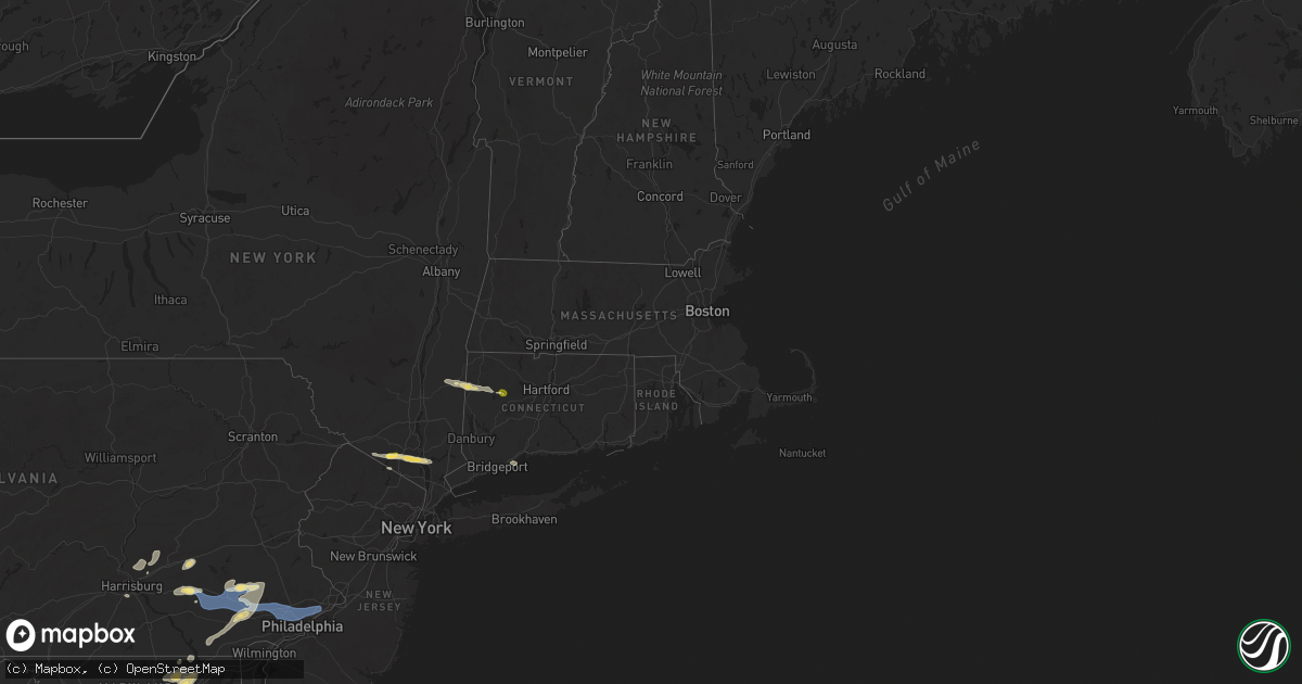
Hail Map in Connecticut on July 8, 2025
Get this storm
July 8 map
$229
one time, instant access
Download today. No call, no setup
Keep the $229
Bought the map and want the full workflow? Apply the entire $229 to a subscription within 7 days. None of it is wasted.
Every map, not just this one
This buys you this map. Subscription and you get every map we run, in the markets you choose from a few cities to whole states to nationwide. Plus real-time alerts the moment a storm fires.
Contact data
Name, contact info, occupancy, even credit band for addresses in the footprint. You go from where it hit to who to call.
Become the source they trust
Unlimited branding weather history reports on demand. You already have the documented answer ready for the property owner, and you are the one who showed up with it.
Property data and RoofTrace estimates
Pull up any address you have got, its value and the exact code rules for that jurisdiction, straight from One Click Code. Then RoofTrace estimates the squares, pitch, and roof value, priced the way you price.
Storm reports in Connecticut
Connecticut
| Date | Description |
|---|---|
| 07/08/20251:40 PM CDT | Strong wind gusts associated with thunderstorms resulted in a few downed trees as well as large branches too. |
| 07/08/202512:59 PM CDT | Social media report of multiple downed trees... Including one that damaged an outhouse... Near the white memorial conservation center. Time estimated from radar. |
| 07/08/202512:40 PM CDT | Tree down on wires on cornwall road. |
| 07/08/202512:38 PM CDT | Multiple trees and wires downed on route 7. The roadway was closed to traffic. |
| 07/07/202510:50 PM CDT | Northbound side of i-395 between mile markers 37-38 near killingly had a large tree blocking the right lane. Relayed by amateur radio. |
| 07/07/202510:45 PM CDT | Tree down blocking part of riverside drive in thompson. Relayed by amateur radio. |
All States Impacted by Hail Map on July 8, 2025
Cities Impacted by Hail Map on July 8, 2025
- Montreal, MO
- Stoutland, MO
- Warwick, NY
- Millbrook, NY
- Moncks Corner, SC
- Ridgeville, SC
- Summerville, SC
- Cottage Grove, TN
- Palmersville, TN
- Monroe, NY
- Tuxedo Park, NY
- Puryear, TN
- Wassaic, NY
- Sharon, CT
- Amenia, NY
- Southfields, NY
- Sussex, NJ
- Cadiz, KY
- Kent, CT
- Stony Point, NY
- Dover Plains, NY
- Branchville, NJ
- Cornwall Bridge, CT
- Bonneau, SC
- Saint Stephen, SC
- Hamburg, NJ
- Vernon, NJ
- Thiells, NY
- Garnerville, NY
- West Haverstraw, NY
- Tomkins Cove, NY
- Pomona, NY
- Pangburn, AR
- Litchfield, CT
- Harwinton, CT
- Northfield, CT
- Iron River, MI
- Cushing, OK
- Croton On Hudson, NY
- Bantam, CT
- Montrose, NY
- Haverstraw, NY
- Ossining, NY
- Keysville, GA
- Hopkinsville, KY
- Warrenton, MO
- Trout Creek, MI
- Sterling Forest, NY
- Ladson, SC
- Chandler, OK
- Stroud, OK
- Crescent, OK
- Harrisburg, PA
- Annville, PA
- Grantville, PA
- Arkadelphia, AR
- Dauphin, PA
- Hartsville, SC
- Lynchburg, SC
- Orangeburg, SC
- Saint Matthews, SC
- Waynesboro, GA
- Perkins, OK
- Tryon, OK
- California, MO
- Jamestown, MO
- Tower City, PA
- Stockton, MO
- Crystal Falls, MI
- Eastover, SC
- Timmonsville, SC
- Twin City, GA
- Swainsboro, GA
- Blenheim, SC
- Cameron, SC
- Troy, MO
- Hawk Point, MO
- Williamsville, IL
- Riverton, IL
- Broken Bow, OK
- Wright City, OK
- Pittsburg, MO
- Wheatland, MO
- Flemington, MO
- Gurdon, AR
- Lititz, PA
- Manheim, PA
- Paducah, TX
- Marthasville, MO
- Corona, NM
- Alpha, MI
- Bolivar, MO
- Polk, MO
- Mechanicsburg, PA
- Lewisberry, PA
- Vaughn, NM
- Old Monroe, MO
- Moscow Mills, MO
- Sparkman, AR
- Ephrata, PA
- Stevens, PA
- Rhine, GA
- Milan, GA
- Darlington, SC
- O'Fallon, MO
- Carthage, AR
- Myerstown, PA
- Richland, PA
- Florence, SC
- Newmanstown, PA
- Lebanon, PA
- Bethel, PA
- Rehrersburg, PA
- Womelsdorf, PA
- Society Hill, SC
- Miami, FL
- Akron, PA
- Leola, PA
- New Holland, PA
- East Earl, PA
- Terre Hill, PA
- Denver, PA
- Gordonville, PA
- Narvon, PA
- Honey Brook, PA
- Morgantown, PA
- Niagara, WI
- Dunbar, WI
- Glenmoore, PA
- Elverson, PA
- Pembine, WI
- The Plains, VA
- Middleburg, VA
- Dillon, SC
- Hamer, SC
- Marion, SC
- Latta, SC
- Sherman, IL
- Mohnton, PA
- Downingtown, PA
- Birdsboro, PA
- Chester Springs, PA
- Stanardsville, VA
- Snow, OK
- Golden Eagle, IL
- Brussels, IL
- White Sands Missile Range, NM
- Westmoreland, TN
- Lake View, SC
- Florence, WI
- Bernville, PA
- Dickens, TX
- Buffalo, IL
- Encino, NM
- Sykesville, MD
- Las Cruces, NM
- Exton, PA
- Pottstown, PA
- Malvern, PA
- Phoenixville, PA
- Amberg, WI
- Daggett, MI
- Wayne, PA
- King Of Prussia, PA
- Oaks, PA
- Norristown, PA
- Douglassville, PA
- Upperville, VA
- Marshall, VA
- Rattan, OK
- Lumber City, GA
- Decatur, AL
- Conshohocken, PA
- Berwyn, PA
- Devon, PA
- Villanova, PA
- Newtown Square, PA
- Bridgeport, PA
- Plymouth Meeting, PA
- Moundridge, KS
- Hesston, KS
- Halstead, KS
- Burrton, KS
- Newton, KS
- Kirkwood, PA
- Fargo, OK
- Genoa, CO
- Franklin, KY
- Milford, CT
- Organ, NM
- Spur, TX
- Bryn Mawr, PA
- Gladwyne, PA
- Lafayette Hill, PA
- Philadelphia, PA
- Haverford, PA
- Ardmore, PA
- Narberth, PA
- Wynnewood, PA
- Merion Station, PA
- Bala Cynwyd, PA
- Oklahoma City, OK
- Lexington Park, MD
- Patuxent River, MD
- Havertown, PA
- Glenside, PA
- Elkins Park, PA
- Wyncote, PA
- Portland, TN
- Quarryville, PA
- Christiana, PA
- Atglen, PA
- Cochranville, PA
- Boyertown, PA
- Reading, PA
- Jenkintown, PA
- Cheltenham, PA
- Huntingdon Valley, PA
- Pawnee, IL
- Glenwood, GA
- Cameron, NC
- Broadway, NC
- Sanford, NC
- Lillington, NC
- Spring Lake, NC
- Bunnlevel, NC
- Red Springs, NC
- Pembroke, NC
- Arriba, CO
- Mount Vernon, GA
- Spring City, PA
- Cloudcroft, NM
- Bensalem, PA
- Hill City, SD
- Hartsburg, IL
- Flagler, CO
- Caspian, MI
- Gaastra, MI
- Linden, NC
- Gilbertsville, PA
- Royersford, PA
- Schwenksville, PA
- Coatesville, PA
- Parkesburg, PA
- Vona, CO
- Seibert, CO
- Stratton, CO
- Uvalda, GA
- Ailey, GA
- Burdett, KS
- North Newton, KS
- Las Vegas, NM
- Limon, CO
- Pecos, NM
- Goddard, KS
- Wichita, KS
- Drummond, OK
- Rush Center, KS
- Rozel, KS
- Nekoma, KS
- Lamar, MO
- Golden City, MO
- Brookline, MO
- Springfield, MO
- Republic, MO
- Nixa, MO
- Clarksdale, MS
- Coalgate, OK
- Kingfisher, OK
- Lane, OK
- Stringtown, OK
- Atoka, OK
- Clearwater, KS
- Duncan, MS
- Alligator, MS
- Okeechobee, FL
- Wausaukee, WI
- Wallace, MI
- Cimarron, KS
- Pylesville, MD
- Street, MD
- Offerle, KS
- Plains, TX
- Whiteford, MD
- Sedgwick, KS
- Larned, KS
- Pittsburg, OK
- Olar, SC
- Fallston, MD
- Baldwin, MD
- Forest Hill, MD
- Jarrettsville, MD
- Thorndale, PA
- Viola, KS
- Mcconnell Afb, KS
- Laverne, OK
- Darlington, MD
- Post, TX
- Ashdown, AR
- Mount Hope, KS
- New Berlin, IL
- Pleasant Plains, IL
- Colwich, KS
- Maize, KS
- Valley Center, KS
- Eureka, KS
- Andale, KS
- Garden Plain, KS
- Phoenix, MD
- Monkton, MD
- Spearville, KS
- Bentley, KS
- Derby, KS
- Hanover, NM
- Bamberg, SC
- Denmark, SC
- Ingalls, KS
- Shattuck, OK
- Fayetteville, NC
- Denver City, TX
- Kechi, KS
- Mayfield, KS
- Conway Springs, KS
- Argonia, KS
- Milton, KS
- Cheney, KS
- Wellington, KS
- Milan, KS
- Caldwell, KS
- Joppa, MD
- Mulberry, KS
- Gage, OK
- Erwin, NC
- Enid, OK
- Rosedale, MD
- Middle River, MD
- Parkville, MD
- Perry Hall, MD
- Nottingham, MD
- Kingsville, MD
- White Marsh, MD
- Clever, MO
- Weatherford, OK
- Geary, OK
- Bethune, CO
- Mindenmines, MO
- Liberal, MO
- Bel Air, MD
- Churchville, MD
- Abingdon, MD
- Essex, MD
- Upper Falls, MD
- Pittsburg, KS
- Frontenac, KS
- Ensign, KS
- Fowler, KS
- Dodge City, KS
- Minneola, KS
- Waukomis, OK
- Jasper, MO
- Bonham, TX
- Telephone, TX
- Dodd City, TX
- Aberdeen, MD
- Glen Arm, MD
- Lockesburg, AR
- Ford, KS
- Murdock, KS
- Cope, SC
- Ivanhoe, TX
- Dunn, NC
- Dundalk, MD
- Pope, MS
- Oakland, MS
- Medford, OK
- Deer Creek, OK
- Hunter, OK
- Lamont, OK
- Pond Creek, OK
- Haven, KS
- Hennessey, OK
- Stephenson, MI
- Honey Grove, TX
- Suring, WI
- Keshena, WI
- Ames, OK
- Sardis, MS
- Cisco, TX
- Gunpowder, MD
- Sparrows Point, MD
- Akron, CO
- Otis, CO
- Yuma, CO
- Gillett, WI
- Odonnell, TX
- Tahoka, TX
- Havre De Grace, MD
- Baltimore, MD
- Edgewood, MD
- Perkiomenville, PA
- Kremlin, OK
- Fairmont, OK
- Garber, OK
- Douglas, OK
- Bison, OK
- McCune, KS
- Cherokee, KS
- Plymouth, MA
- Jetmore, KS
- Kingman, KS
- Brooklet, GA
- Rock Hall, MD
- Meade, KS
- Englewood, KS
- Gate, OK
- Pound, WI
- Mountain, WI
- Brownfield, TX
- Chestertown, MD
- Yale, VA
- Forgan, OK
- Follett, TX
- Chester, MD
- Warwick, RI
- Lamesa, TX
- Barrington, RI
- Warren, RI
- Bristol, RI
- Stevensville, MD
- Cordell, OK
- Gotebo, OK
- Oronogo, MO
- Porterfield, WI
- Sumner, TX
- Grasonville, MD
- Annapolis, MD
- Hobart, OK
- Lone Wolf, OK
- Roosevelt, OK
- Bluff City, KS
- Watonga, OK
- Girard, KS
- Ingalls, MI
- Weir, KS
- Petty, TX
- Saint Michaels, MD
- Bozman, MD
- Mcdaniel, MD
- Wittman, MD
- Claiborne, MD
- Blair, OK
- Altus, OK
- Booker, TX
- Roanoke, VA
- Dighton, KS
- Pattonville, TX
- Magnolia, AR
- Rosston, OK
- Paris, TX
- Prince Frederick, MD
- Asbury, MO
- Menominee, MI
- Easton, MD
- Royal Oak, MD
- Sherwood, MD
- Childress, TX
- Quanah, TX
- Chillicothe, TX
- Crowell, TX
- Salem, VA
- Macon, GA
- Cotulla, TX
- Neavitt, MD
- Courtland, MS
- Centreville, MD
- Seymour, TX
- Cream Ridge, NJ
- Joint Base Mdl, NJ
- Wrightstown, NJ
- Cookstown, NJ
- Salem, NJ
- Roswell, NM
- Ness City, KS
- Clyo, GA
- Jerico Springs, MO
- Tilghman, MD
- Shamrock, TX
- Estill, SC
- Garnett, SC
- Pineland, SC
- Healy, KS
- Allentown, NJ
- New Egypt, NJ
- Chesapeake Beach, MD
- Huntingtown, MD
- Luray, SC
- Queen Anne, MD
- Thomas, OK
- Frederick, OK
- Hollister, OK
- Harrold, TX
- Oklaunion, TX
- Davidson, OK
- Tatum, NM
- Garden City, KS
- Peck, KS
- Cunningham, KS
- Haysville, KS
- Wellington, TX
- Fall River, MA
- Tappahannock, VA
- Vernon, TX
- Benjamin, TX
- Willow, OK
- Turon, KS
- Pembroke, GA
- Gail, TX
- Waverly, VA
- Stony Creek, VA
- Oxford, MD
- Cambridge, MD
- Idalia, CO
- Burlington, CO
- Goodland, KS
- Wray, CO
- Saint Francis, KS
- Kanorado, KS
- Sharon Springs, KS
- Wallace, KS
- Levant, KS
- Edson, KS
- Winona, KS
- Colby, KS
- Brewster, KS
- Monument, KS
- Brunson, SC
- Abrams, WI
- Brillion, WI
- Frankford, DE
- Sussex, VA
- S Coffeyville, OK
- San Jose, NM
- Brussels, WI
- Casco, WI
- Luxemburg, WI
- Beeler, KS
- Varnville, SC
- Dagsboro, DE
- Millsboro, DE
- Hydro, OK
- Queenstown, MD
- Dunnsville, VA
- Munday, TX
- Knox City, TX
- Corn, OK
- Colony, OK
- Ashland, KS
- Lenapah, OK
- Electra, TX
- O'Brien, TX
- Rochester, TX
- Haskell, TX
- Weinert, TX
- Sayre, OK
- Elk City, OK
- Canute, OK
- Sterling, CO
- Church Creek, MD
- Hollis, OK
- Delaware, OK
- South Kent, CT
- Buffalo, OK
- Kaukauna, WI
- Greenleaf, WI
- Forest Junction, WI
- Swansea, MA
- Copan, OK
- Butler, OK
- Clinton, OK
- Foss, OK
- Leedey, OK
- Custer City, OK
- Taloga, OK
- Arapaho, OK
- Camargo, OK
- Sharon, OK
- Arnett, OK
- Vici, OK
- Higgins, TX
- Durham, OK
- Reydon, OK
- Hammon, OK
- Cheyenne, OK
- Crawford, OK
- Carter, OK
- Naples, FL
- Tallulah, LA
- Booneville, MS
- Levelland, TX
- Mayville, WI
- Skellytown, TX
- Dodson, TX
- Beaver, OK
- Stamford, TX
- Rule, TX
- Lueders, TX
- Abilene, TX
- Avoca, TX
- Albany, TX
- Throckmorton, TX
- Goree, TX
- Newcastle, TX
- Olney, TX
- Woodson, TX
- Dill City, OK
- Sentinel, OK
- Bessie, OK
- Granite, OK
- Rocky, OK
- Mountain View, OK
- Florence, AL
- Iron City, TN
- Spearman, TX
- Borger, TX
- Liberal, KS
- Balko, OK
- Courtland, VA
- Jetersville, VA
- Morse, TX
- Windom, TX
- Ellabell, GA
- McKenney, VA
- Crosbyton, TX
- Atwood, KS
- Thayer, KS
- Cashion, OK
- Coila, MS
- Panhandle, TX
- White Deer, TX
- Selbyville, DE
- Bishopville, MD
- Corsicana, TX
- Edmond, OK
- Weskan, KS
- Piedmont, OK
- Gruver, TX
- Bartlesville, OK
- Canadian, TX
- Nicholls, GA
- Fishing Creek, MD
- Yukon, OK
- Fort Stewart, GA
- Oakley, KS
- Desdemona, TX
- Dublin, TX
- Stephenville, TX
- Breckenridge, TX
- Comanche, TX
- Snyder, TX
- Hermleigh, TX
- Ira, TX
- Big Spring, TX
- Colorado City, TX
- Coahoma, TX
- Westbrook, TX
- Stinnett, TX
- Rexford, KS
- Hoxie, KS
- De Leon, TX
- Gorman, TX
- Erick, OK
- Sweetwater, OK
- McDonald, KS
- Miami, TX
- Grand Prairie, TX
- Groom, TX
- Mangum, OK
- Dallas, TX
- Arlington, TX
- Burlington, ND
- Gould, OK
- Eldorado, OK
- Nenzel, NE
- Kilgore, NE
- Satanta, KS
- Ulysses, KS
- Elmer, OK
- Glen Rose, TX
- Sawyer, ND
- Irving, TX
- Vinson, OK
- Tulia, TX
- Bluff Dale, TX
- Velva, ND
- Minot, ND
- Kress, TX
- New Canton, VA
- Norwich, ND
- Millen, GA
- Allen, TX
- Caddo Mills, TX
- Cedar Hill, TX
- Kyle, SD
- Voltaire, ND
- Fort Worth, TX
- Hurst, TX
- Haltom City, TX
- Mountain Park, OK
- Granville, ND
- Quitaque, TX
- Turkey, TX
- Rotan, TX
- Snyder, OK
- Richmond, VA
- Deering, ND
- Bantry, ND
- Glenburn, ND
- Upham, ND
- Martin, SD
- Tuthill, SD
- Newburg, ND
- Lancaster, TX
- Maxbass, ND
- Saint Francis, SD
- Desoto, TX
- Balfour, ND
- Cody, NE
- Bedford, TX
- Tolar, TX
- North Richland Hills, TX
- Crookston, NE
- Valentine, NE


