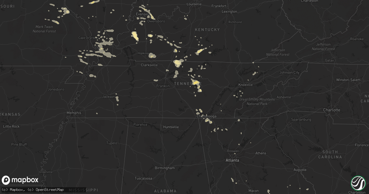
Hail Map in Tennessee on July 8, 2022
Get this storm
July 8 map
$229
one time, instant access
Download today. No call, no setup
Keep the $229
Bought the map and want the full workflow? Apply the entire $229 to a subscription within 7 days. None of it is wasted.
Every map, not just this one
This buys you this map. Subscription and you get every map we run, in the markets you choose from a few cities to whole states to nationwide. Plus real-time alerts the moment a storm fires.
Contact data
Name, contact info, occupancy, even credit band for addresses in the footprint. You go from where it hit to who to call.
Become the source they trust
Unlimited branding weather history reports on demand. You already have the documented answer ready for the property owner, and you are the one who showed up with it.
Property data and RoofTrace estimates
Pull up any address you have got, its value and the exact code rules for that jurisdiction, straight from One Click Code. Then RoofTrace estimates the squares, pitch, and roof value, priced the way you price.
Storm reports in Tennessee
Tennessee
| Date | Description |
|---|---|
| 07/08/20225:40 PM CDT | Reports of several trees down across the area near and south of whitwell. Time is estimated from radar. |
| 07/08/20224:45 PM CDT | Reports of trees across the region and also towards hwy 25. |
| 07/08/20224:18 PM CDT | Trees reported down around sparta. Turntable rd @ white county middle school... And breeding drive. |
| 07/08/20224:15 PM CDT | Tree down at golden mountain rd and charles hennessee road... Blocking the road. Time estimated via radar. |
| 07/08/20224:05 PM CDT | Reports and photos of trees down in the area. Time estimated from radar. |
| 07/08/20224:05 PM CDT | Social media relay of several trees down via local broadcast media. Time is estimated from radar. |
| 07/08/20223:59 PM CDT | Tree down blocking jones lane in vines ridge community. Time estimated via radar. |
| 07/08/20223:57 PM CDT | ***sub severe report*** tree down on hanging limb rd |
| 07/08/20223:00 AM CDT | 2 trees and a fence were blown down along gladeville rd. |
| 07/08/20222:40 AM CDT | At 740 PM EDT, severe thunderstorms were located along a line extending from near Ooltewah to Boynton to Chickamauga, moving east at 15 mph. HAZARD...60 mph wind gusts and quarter size hail. SOURCE...Radar indicated. IMPACT...Hail damage to vehicles is expected. Expect wind damage to roofs, siding, and trees. Locations impacted include... Ringgold, Fort Oglethorpe, Chickamauga, Varnell, Tunnel Hill, Cohutta, Wood Station, Indian Springs, Graysville, Blue Spring, Boynton, Beaumont, Rock Spring, East Ridge, Apison and Fairview. |
| 07/08/202212:25 AM CDT | At 524 PM CDT, a severe thunderstorm was located near Whitwell, or 12 miles north of Jasper, moving southeast at 10 mph. HAZARD...60 mph wind gusts. SOURCE...Radar indicated. IMPACT...Expect damage to roofs, siding, and trees. Locations impacted include... Whitwell, Powells Crossroads, Martin Springs, Chimneys State Park, Lone Oak and Griffith Creek. |
| 07/08/202212:22 AM CDT | At 522 PM EDT, a severe thunderstorm was located over Rutledge, moving southeast at 20 mph. HAZARD...60 mph wind gusts. SOURCE...Radar indicated. IMPACT...Expect damage to roofs, siding, and trees. Locations impacted include... Morristown, Rutledge, Bean Station, Thorn Hill, Panther Creek State Park, Alpha, Joppa and Buffalo Springs. |
| 07/08/202212:05 AM CDT | At 505 PM CDT, a severe thunderstorm was located near Elkton, moving east at 20 mph. HAZARD...60 mph wind gusts and penny size hail. SOURCE...Radar indicated. IMPACT...Expect damage to roofs, siding, and trees. This severe thunderstorm will remain over mainly rural areas of southwestern Logan County, including the following locations... Cave Springs, Keysburg, Dot, Old Volney, Lickskillet, Schley and Olmstead. |
| 07/07/202211:59 PM CDT | At 459 PM EDT, a severe thunderstorm was located 8 miles south of Plainview, or 11 miles northeast of Knoxville, moving east at 30 mph. HAZARD...60 mph wind gusts. SOURCE...Radar indicated. IMPACT...Expect damage to roofs, siding, and trees. Locations impacted include... Knoxville, Sevierville, Jefferson City, Dandridge, New Market, Strawberry Plains, Blaine, House Mountain State Park, Maloneyville and Mascot.This includes the following highways... Interstate 40 in Tennessee between mile markers 392 and 423. Interstate 81 in Tennessee between mile markers 1 and 2. |
| 07/07/202211:20 PM CDT | At 419 PM CDT, a severe thunderstorm was located near Spencer, moving southeast at 20 mph. HAZARD...60 mph wind gusts and nickel size hail. SOURCE...Radar indicated. IMPACT...Expect damage to roofs, siding, and trees. Locations impacted include... Spencer, Doyle, Virgin Falls State Natural Area and Fall Creek Falls State Park. |
| 07/07/202210:47 PM CDT | At 346 PM CDT, a severe thunderstorm was located near Smithville, moving east at 15 mph. HAZARD...60 mph wind gusts and penny size hail. SOURCE...Radar indicated. IMPACT...Expect damage to roofs, siding, and trees. Locations impacted include... Cookeville, Sparta, Burgess Falls State Park, Hamptons Crossroads and Bakers Crossroads.This includes Interstate 40 between mile markers 272 and 276. |
| 07/07/20229:22 PM CDT | At 222 PM CDT, a severe thunderstorm was located 8 miles south of Red Boiling Springs, or near Willette, moving east at 15 mph. HAZARD...60 mph wind gusts and penny size hail. SOURCE...Radar indicated. IMPACT...Expect damage to roofs, siding, and trees. Locations impacted include... Gainesboro, Pleasant Shade and Whitleyville. |
All States Impacted by Hail Map on July 8, 2022
Cities Impacted by Hail Map on July 8, 2022
- Hilger, MT
- Box Elder, MT
- Havre, MT
- Sunburst, MT
- Valier, MT
- Hinsdale, MT
- Whitewater, MT
- Saco, MT
- Forsyth, MT
- Brusett, MT
- Ledger, MT
- Conrad, MT
- Shelby, MT
- Veteran, WY
- Yoder, WY
- Wheatland, WY
- Torrington, WY
- Harrison, NE
- Lingle, WY
- De Soto, MO
- Denton, MT
- Dodson, MT
- Malta, MT
- Gildford, MT
- Chinook, MT
- Hays, MT
- Harlem, MT
- Vergennes, IL
- Elkville, IL
- Cisne, IL
- Cimarron, NM
- Robards, KY
- Henderson, KY
- Bonne Terre, MO
- Ridgway, IL
- Junction, IL
- Edmond, OK
- Belknap, IL
- Fillmore, IL
- Irving, IL
- Alberton, MT
- Frenchtown, MT
- Missoula, MT
- Huson, MT
- Victor, MT
- Grand Junction, TN
- Hickory Valley, TN
- Eufaula, OK
- Canadian, OK
- Bowling Green, KY
- Oakland, KY
- Balko, OK
- Ekron, KY
- Vine Grove, KY
- Ava, IL
- Valles Mines, MO
- Rutledge, TN
- Pulaski, IL
- Broseley, MO
- Poplar Bluff, MO
- Essex, MO
- Parma, MO
- Dexter, MO
- Cairo, IL
- Obion, TN
- Ridgely, TN
- Gainesville, GA
- Galata, MT
- Oilmont, MT
- Chester, MT
- Whitlash, MT
- Joplin, MT
- Kevin, MT
- Bethalto, IL
- Magnolia, KY
- Summersville, KY
- Colorado Springs, CO
- Gillette, WY
- Douglas, WY
- Raton, NM
- Perryton, TX
- Stevensville, MT
- Clinton, MT
- Ovando, MT
- Choteau, MT
- Seeley Lake, MT
- Hamilton, MT
- Augusta, MT
- Lincoln, MT
- Corvallis, MT
- Bonner, MT
- Taloga, OK
- Akron, CO
- Shawmut, MT
- Judith Gap, MT
- Durham, OK
- Amarillo, TX
- East Helena, MT
- Clancy, MT
- Hillsboro, IL
- Cheyenne, WY
- Ashley, IL
- Oakdale, IL
- Nashville, IL
- Central City, KY
- Florissant, CO
- Penrose, CO
- Cottonwood, ID
- Imnaha, OR
- Ramsey, IL
- Vandalia, IL
- Bingham, IL
- Mulberry Grove, IL
- Evansville, IN
- Sparta, IL
- Baldwin, IL
- Hydro, OK
- Colony, OK
- Elgin, ND
- Almont, ND
- Glen Ullin, ND
- Carson, ND
- Louisville, IL
- Flora, IL
- Smiths Grove, KY
- Brownsville, KY
- Bigfork, MT
- Big Sandy, MT
- Inverness, MT
- Fort Benton, MT
- Hingham, MT
- Rudyard, MT
- Piedmont, SD
- Deadwood, SD
- Nemo, SD
- Jordan, MT
- Winnett, MT
- Roundup, MT
- Roy, MT
- Stanford, MT
- Helmville, MT
- Ravalli, MT
- Arlee, MT
- Philipsburg, MT
- Lewistown, MT
- Saint Ignatius, MT
- Charlo, MT
- Ronan, MT
- Charleston, MO
- Bertrand, MO
- Graham, KY
- Greenville, KY
- Walters, OK
- Oklahoma City, OK
- Atlanta, GA
- Canadian, TX
- Sikeston, MO
- Morgantown, KY
- Fritch, TX
- Cleveland, TN
- Granite, OK
- Castalian Springs, TN
- Lebanon, TN
- Mount Juliet, TN
- Gallatin, TN
- Fort Rucker, AL
- Piedmont, SC
- Easley, SC
- Dalton, GA
- Chatsworth, GA
- Turkey, TX
- Quitaque, TX
- Toomsboro, GA
- Hollis, OK
- Vinson, OK
- Salem, AL
- Levelland, TX
- Roaring Springs, TX
- Silverton, TX
- La Fayette, GA
- Sugar Valley, GA
- Resaca, GA
- Reynolds, GA
- Ideal, GA
- Butler, GA
- Wadley, AL
- Geary, OK
- Hinton, OK
- Sumner, IL
- Claremont, IL
- Evergreen, CO
- Unadilla, GA
- Elko, GA
- Hawkinsville, GA
- Arnett, OK
- Leedey, OK
- Crawford, OK
- Cheyenne, OK
- Bloomsdale, MO
- Festus, MO
- Mauk, GA
- Pine, CO
- Union City, OK
- El Reno, OK
- Newcastle, WY
- Upton, WY
- Roff, OK
- Allendale, IL
- Mount Carmel, IL
- Drummond, MT
- Spearman, TX
- Highland Home, AL
- Loring, MT
- Whitwell, TN
- Tracy City, TN
- Friendsville, TN
- Goodlettsville, TN
- Higgins, TX
- Columbia, KY
- Russell Springs, KY
- Smithville, TN
- Camilla, GA
- Wetumpka, AL
- Cordell, OK
- Sentinel, OK
- Carter, OK
- Lone Wolf, OK
- Dill City, OK
- Foss, OK
- Olney, IL
- Stinnett, TX
- Dawson Springs, KY
- Princeton, KY
- Mcminnville, TN
- Hastings, OK
- Waurika, OK
- Lafayette, AL
- McRae Helena, GA
- Alamo, GA
- Omaha, GA
- Pitts, GA
- Rochelle, GA
- Goshen, AL
- Grady, AL
- Luverne, AL
- Lapine, AL
- Ullin, IL
- Dundas, IL
- Newton, IL
- Ingraham, IL
- Calumet, OK
- Walling, TN
- Silver Point, TN
- Hickman, TN
- Sparta, TN
- Baxter, TN
- Lancaster, TN
- Quebeck, TN
- Hill City, SD
- Comanche, OK
- Bragg City, MO
- Holcomb, MO
- Drakesboro, KY
- Beaver Dam, KY
- Edmonton, KY
- Chestnut Mound, TN
- Buffalo Valley, TN
- Elmwood, TN
- Williamson, GA
- Zebulon, GA
- Conner, MT
- Sula, MT
- Darby, MT
- Texico, NM
- Farwell, TX
- Sylvania, GA
- Swainsboro, GA
- Providence, KY
- Clay, KY
- Marion, KY
- Dittmer, MO
- Lonedell, MO
- Grubville, MO
- Belleville, IL
- Millstadt, IL
- East Saint Louis, IL
- Custer, SD
- Goreville, IL
- Buncombe, IL
- Sturgis, KY
- Richland, IN
- Haubstadt, IN
- Rockport, IN
- Newburgh, IN
- Boonville, IN
- Cynthiana, IN
- Elberfeld, IN
- Chandler, IN
- Owensboro, KY
- Poseyville, IN
- Newbern, TN
- Wilkesboro, NC
- Boomer, NC
- Ferguson, NC
- Purlear, NC
- Cunningham, KY
- Kevil, KY
- Matthews, MO
- Luray, TN
- Jacks Creek, TN
- Huron, TN
- Reagan, TN
- Lexington, TN
- Knoxville, TN
- Corryton, TN
- Richburg, SC
- Arcadia, OK
- Potosi, MO
- Rumsey, KY
- Franklin, KY
- Scottsville, KY
- Bethel Springs, TN
- Finger, TN
- Enville, TN
- Allons, TN
- Chattanooga, TN
- Yukon, OK
- Greensburg, KY
- Lead, SD
- Sunray, TX
- Morse, TX
- New Madrid, MO
- Lilbourn, MO
- Catron, MO
- Marston, MO
- Wickliffe, KY
- Williston, SC
- Anderson, SC
- Central, SC
- Liberty, SC
- Williamston, SC
- Pendleton, SC
- North, SC
- Neeses, SC
- Flintstone, GA
- Fort Oglethorpe, GA
- Ringgold, GA
- Rock Spring, GA
- Rossville, GA
- Chickamauga, GA
- Albertville, AL
- Boaz, AL
- Crossville, AL
- Duncan, OK
- Abernathy, TX
- Shallowater, TX
- Ariton, AL
- New Brockton, AL
- Gould, OK
- Beaumont, KY
- Burkesville, KY
- Breeding, KY
- Summer Shade, KY
- Sacramento, KY
- Bremen, KY
- Doyle, TN
- Spencer, TN
- Rock Island, TN
- Shobonier, IL
- Maryville, TN
- Belgrade, MO
- Alvaton, KY
- Rockport, KY
- Tamms, IL
- Thompsonville, IL
- Macedonia, IL
- Bethpage, TN
- Westmoreland, TN
- Portland, TN
- Anna, IL
- Brownstown, IL
- Bloomfield, MO
- Nicholls, GA
- Eufaula, AL
- Barnesville, GA
- Meansville, GA
- Simpson, IL
- Healdton, OK
- Graham, OK
- Milan, GA
- Channing, TX
- Okarche, OK
- Union City, TN
- Hickman, KY
- Fulton, KY
- Anton, CO
- Arriba, CO
- Genoa, CO
- Lindon, CO
- Sequatchie, TN
- Louisville, GA
- Rupert, GA
- Bismarck, MO
- Ironton, MO
- Centertown, KY
- Fort Branch, IN
- Dowelltown, TN
- Jamestown, KY
- Albany, KY
- Greenback, TN
- Allensville, KY
- Trenton, KY
- Guthrie, KY
- Elkton, KY
- Pembroke, KY
- Hopkinsville, KY
- Livingston, TN
- East Prairie, MO
- Loco, OK
- Irondale, MO
- Caledonia, MO
- Rinard, IL
- Clay City, IL
- Johnsonville, IL
- Athens, TN
- Riceville, TN
- Toccoa, GA
- Blaine, TN
- Powder Springs, TN
- Washburn, TN
- Hilham, TN
- Celina, TN
- White Plains, KY
- Whitleyville, TN
- Red Boiling Springs, TN
- Pleasant Shade, TN
- Carthage, TN
- Booker, TX
- Adrian, GA
- Soperton, GA
- Madisonville, KY
- Bardwell, KY
- McLeansboro, IL
- Brandenburg, KY
- Panama, IL
- Sorento, IL
- Donnellson, IL
- Walshville, IL
- Norris City, IL
- Omaha, IL
- Cope, CO
- Cypress, IL
- Dongola, IL
- West Paducah, KY
- Paducah, KY
- Millers Creek, NC
- Gradyville, KY
- Mosquero, NM
- Miami, TX
- Morganton, GA
- Blairsville, GA
- Rhine, GA
- Abbeville, GA
- Millen, GA
- Vienna, IL
- Stonefort, IL
- Ozark, IL
- Kooskia, ID
- Stites, ID
- Davis, OK
- Adolphus, KY
- La Center, KY
- Mound City, IL
- Barlow, KY
- Hickory, KY
- Mayfield, KY
- Fancy Farm, KY
- Villa Ridge, IL
- Clinton, KY
- Grand Chain, IL
- Mounds, IL
- Arlington, KY
- Brookport, IL
- Metropolis, IL
- Greenville, IL
- Coffeen, IL
- Glens Fork, KY
- Cookeville, TN
- Tazewell, TN
- Jasper, TN
- Harrogate, TN
- Cumberland Gap, TN
- Pickens, SC
- Georgiana, AL
- Rebecca, GA
- Livermore, CO
- Corydon, KY
- Karnak, IL
- Sturgis, SD
- Marysville, MT
- Canyon Creek, MT
- Shields, ND
- Gainesboro, TN
- Clayton, NM
- Park Hills, MO
- Leadwood, MO
- Willow, OK
- Fountain Run, KY
- Moss, TN
- Goodwell, OK
- Texhoma, OK
- Forsyth, GA
- Trinidad, CO
- Guild, TN
- Gruver, TX
- Yemassee, SC
- Kellyton, AL
- Rockford, AL
- Ranger, GA
- Noble, IL
- Wheeler, IL
- Wildwood, GA
- Hayti, MO
- Wardell, MO
- Vonore, TN
- Philadelphia, TN
- Sweetwater, TN
- Loudon, TN
- Ramer, AL
- Mathews, AL
- Ellijay, GA
- Mill Creek, OK
- Wadley, GA
- Kinmundy, IL
- Saint Peter, IL
- Cowden, IL
- Brush Creek, TN
- Pocahontas, IL
- Roundhill, KY
- Jetson, KY
- Columbia, IL
- East Carondelet, IL
- Xenia, IL
- Muldraugh, KY
- Ozark, AL
- Hennepin, OK
- Wadesville, IN
- Calhoun, IL
- Dieterich, IL
- Saint Francisville, IL
- West Salem, IL
- Walhalla, SC
- Tamassee, SC
- Glasgow, KY
- Anniston, MO
- Columbus, KY
- Granville, TN
- Bloomington Springs, TN
- Fairview, TN
- Kingston Springs, TN
- White Bluff, TN
- Pegram, TN
- Lenoir, NC
- Granite Falls, NC
- Dahlonega, GA
- Childress, TX
- Salley, SC
- Summerville, GA
- Bailey, CO
- Conifer, CO
- Reed, KY
- Spottsville, KY
- Hartsville, TN
- Holland, KY
- Tompkinsville, KY
- Honoraville, AL
- Irwinton, GA
- Cut Bank, MT
- French Village, MO
- Union Mills, NC
- Rutherfordton, NC
- Hudson, NC
- Red Level, AL
- Cumming, GA
- Goodwater, AL
- Fairfax, SC
- Luray, SC
- Ridgeland, SC
- Coosawhatchie, SC
- Bessie, OK
- Great Falls, MT
- Cascade, MT
- Reserve, MT
- Larslan, MT
- Poplar, MT
- Wolf Point, MT
- Plentywood, MT
- Peerless, MT
- Zortman, MT
- Dagmar, MT
- Scobey, MT
- Nashua, MT
- Saint Marie, MT
- Grenora, ND
- Westby, MT
- Glasgow, MT
- Redstone, MT
- Frazer, MT
- Winifred, MT
- Fort Peck, MT
- Outlook, MT
- Antelope, MT
- Flaxville, MT
- Fort Laramie, WY


