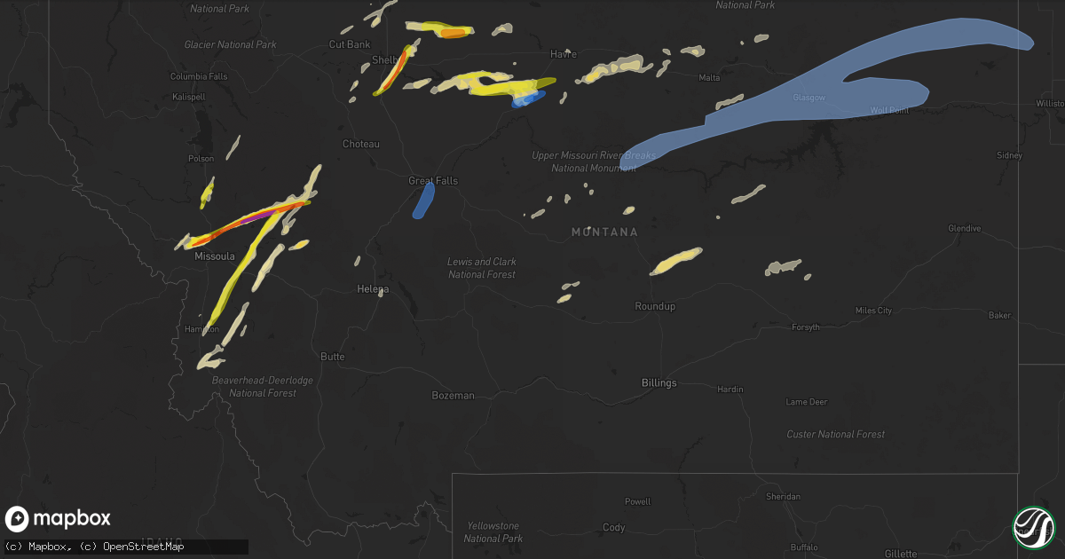
Hail Map in Montana on July 8, 2022
Get this storm
July 8 map
$229
one time, instant access
Download today. No call, no setup
Keep the $229
Bought the map and want the full workflow? Apply the entire $229 to a subscription within 7 days. None of it is wasted.
Every map, not just this one
This buys you this map. Subscription and you get every map we run, in the markets you choose from a few cities to whole states to nationwide. Plus real-time alerts the moment a storm fires.
Contact data
Name, contact info, occupancy, even credit band for addresses in the footprint. You go from where it hit to who to call.
Become the source they trust
Unlimited branding weather history reports on demand. You already have the documented answer ready for the property owner, and you are the one who showed up with it.
Property data and RoofTrace estimates
Pull up any address you have got, its value and the exact code rules for that jurisdiction, straight from One Click Code. Then RoofTrace estimates the squares, pitch, and roof value, priced the way you price.
Storm reports in Montana
Montana
| Date | Description |
|---|---|
| 07/08/20226:42 PM CDT | Photo on social media shows ground covering hail with up to quarter sized stones. Time estimated from radar. |
| 07/08/20226:25 PM CDT | Hail up to quarter size. |
| 07/08/20226:10 PM CDT | Near lake helena... Via ambient weather. |
| 07/08/20225:45 PM CDT | A local report indicates 2.00 inch wind near SEELEY LAKE |
| 07/08/20225:36 PM CDT | A local report indicates 1.75 inch wind near SEELEY LAKE |
| 07/08/20225:21 PM CDT | A local report indicates 1.00 inch wind near 1 WSW FORT CONNAH |
| 07/08/20224:55 PM CDT | A local report indicates 2.00 inch wind near 6 SSW EVARO |
| 07/08/20224:50 PM CDT | A local report indicates 1.75 inch wind near 1 SW EVARO |
| 07/08/20224:48 PM CDT | A local report indicates 1.75 inch wind near 3 SSW EVARO |
| 07/08/20224:45 PM CDT | A local report indicates 1.25 inch wind near 2 W FRENCHTOWN |
| 07/08/20224:45 PM CDT | A local report indicates 2.50 inch wind near 5 SSW EVARO |
| 07/08/20227:49 AM CDT | At 1249 AM MDT, a severe thunderstorm was located 7 miles southwest of Hell Creek Rec Area, or 16 miles north of Jordan, moving east at 25 mph. HAZARD...60 mph wind gusts and quarter size hail. SOURCE...Radar indicated. IMPACT...Hail damage to vehicles is expected. Expect wind damage to roofs, siding, and trees. Locations impacted include... Hell Creek Rec Area. |
| 07/08/20226:30 AM CDT | At 1130 PM MDT, a severe thunderstorm was located 7 miles southeast of Roy, or 29 miles northwest of Winnett, moving northeast at 45 mph. HAZARD...Half dollar size hail. SOURCE...Radar indicated. IMPACT...Damage to vehicles is expected. Locations impacted include... Valentine. |
| 07/08/20225:48 AM CDT | At 1047 PM MDT, severe thunderstorms were located along a line extending from near Opheim to 10 miles northwest of Rock Creek Rec Area, moving east at 40 mph. HAZARD...70 mph wind gusts and penny size hail. SOURCE...Radar indicated. IMPACT...Expect damage to roofs, siding, and trees. Locations impacted include... Glasgow, Wolf Point, Scobey, Poplar, Opheim, Richland, Nashua, Fort Peck, Flaxville, Duck Creek Rec Area, St. Marie, Peerless, The Pines Rec Area, Tampico, Port Of Whitetail, Lustre, Madoc, Fort Peck Marina, Bredette and Port Of Scobey. |
| 07/08/20225:41 AM CDT | At 1040 PM MDT, severe thunderstorms were located along a line extending from 12 miles east of Hell Creek Rec Area to 6 miles southeast of Cohagen, moving east at 55 mph. HAZARD...70 mph wind gusts and penny size hail. SOURCE...Radar indicated. IMPACT...Expect considerable tree damage. Damage is likely to mobile homes, roofs, and outbuildings. Locations impacted include... Circle, Jordan, Brockway, Hillside, Hell Creek Rec Area, Flowing Wells Rest Area, Vida, Cohagen, Nelson Creek Rec Area, Rock Creek Rec Area, Van Norman, Mccloud, Haxby, Weldon, Crow Rock and Watkins. |
| 07/08/20225:07 AM CDT | At 1004 PM MDT, severe thunderstorms were located along a line extending from near Hinsdale to 12 miles west of The Pines Rec Area, moving east at 65 mph. THESE ARE DESTRUCTIVE STORMS FOR CENTRAL VALLEY COUNTY INCLUDING THE CITY OF GLASGOW AND HINSDALE . HAZARD...80 mph wind gusts and penny size hail. SOURCE...Radar indicated. IMPACT...Flying debris will be dangerous to those caught without shelter. Mobile homes will be heavily damaged. Expect considerable damage to roofs, windows, and vehicles. Extensive tree damage and power outages are likely. Locations impacted include... Glasgow, Wolf Point, Richland, Nashua, Fort Peck, Saco, Duck Creek Rec Area, St. Marie, Peerless, The Pines Rec Area, Tampico, Hinsdale, Lustre, Fort Peck Marina, Frazer, Vida, Rock Creek Rec Area, Vandalia, Park Grove and West Fork. |
| 07/08/20224:52 AM CDT | At 951 PM MDT, severe thunderstorms were located along a line extending from near Brusett to 12 miles southwest of Sand Springs, moving east at 25 mph. HAZARD...60 mph wind gusts and penny size hail. SOURCE...Trained weather spotters. IMPACT...Expect damage to roofs, siding, and trees. Locations impacted include... Jordan, Sand Springs, Hell Creek Rec Area, Edwards, Brusett and Steve Fork. |
| 07/08/20224:17 AM CDT | At 917 PM MDT, a severe thunderstorm was located 17 miles northwest of Augusta, or 25 miles southwest of Choteau, moving northeast at 30 mph. HAZARD...Ping pong ball size hail. SOURCE...Radar indicated. IMPACT...People and animals outdoors will be injured. Expect damage to roofs, siding, windows, and vehicles. Locations impacted include... Pishkun Reservoir. |
| 07/08/20224:15 AM CDT | At 914 PM MDT, a severe thunderstorm was located 8 miles northwest of Dodson, or 24 miles northwest of Malta, moving east at 50 mph. THIS IS A DESTRUCTIVE STORM FOR DODSON AND SURROUNDING AREAS. HAZARD...80 mph wind gusts and nickel size hail. SOURCE...Radar indicated. IMPACT...Flying debris will be dangerous to those caught without shelter. Mobile homes will be heavily damaged. Expect considerable damage to roofs, windows, and vehicles. Extensive tree damage and power outages are likely. Locations impacted include... Whitewater, Saco, Dodson, Loring, Sleeping Buffalo and Wagner. |
| 07/08/20224:11 AM CDT | At 910 PM MDT, a severe thunderstorm was located near Fourchette, or 28 miles east of Zortman, moving east at 50 mph. HAZARD...60 mph wind gusts and quarter size hail. SOURCE...Radar indicated. IMPACT...Hail damage to vehicles is expected. Expect wind damage to roofs, siding, and trees. Locations impacted include... Saco, Fourchette, Devils Creek Rec Area, U L Bend Rec Area, Hell Creek Rec Area, Hinsdale, Crooked Creek Rec Area, Phillips, Content, Sun Prairie and The Bentonite Plant. |
| 07/08/20224:09 AM CDT | At 908 PM MDT, a severe thunderstorm was located 13 miles south of Seeley Lake, or 26 miles northwest of Drummond, moving northeast at 35 mph. HAZARD...Tennis ball size hail and 60 mph wind gusts. SOURCE...Radar indicated. IMPACT...People and animals outdoors will be injured. Expect hail damage to roofs, siding, windows, and vehicles. Expect wind damage to roofs, siding, and trees. Locations impacted include... Seeley Lake, Greenough, Woodworth and Clearwater. |
| 07/08/20224:08 AM CDT | At 908 PM MDT, a severe thunderstorm was located near Fort Belknap, or 29 miles east of Chinook, moving east at 65 mph. THIS IS A DESTRUCTIVE STORM FOR Fort Belknap and Harlem. HAZARD...80 mph wind gusts and quarter size hail. SOURCE...Radar indicated. IMPACT...Flying debris will be dangerous to those caught without shelter. Mobile homes will be heavily damaged. Expect considerable damage to roofs, windows, and vehicles. Extensive tree damage and power outages are likely. Locations impacted include... Harlem and Fort Belknap. |
| 07/08/20223:58 AM CDT | At 857 PM MDT, severe thunderstorms were located along a line extending from 8 miles south of Fort Belknap to 6 miles northeast of Zortman to 18 miles west of Fourchette, moving northeast at 45 mph. HAZARD...70 mph wind gusts. SOURCE...Radar indicated. IMPACT...Expect considerable tree damage. Damage is likely to mobile homes, roofs, and outbuildings. Locations impacted include... Hays and Lodge Pole. |
| 07/08/20223:55 AM CDT | At 854 PM MDT, a severe thunderstorm was located near Flatwillow, or 13 miles south of Winnett, moving east at 30 mph. HAZARD...60 mph wind gusts and quarter size hail. SOURCE...Radar indicated. IMPACT...Hail damage to vehicles is expected. Expect wind damage to roofs, siding, and trees. Locations impacted include... Winnett, Flatwillow, Mosby, Petrolia Lake and Cat Creek. |
| 07/08/20223:50 AM CDT | At 850 PM MDT, a severe thunderstorm was located 12 miles east of Bonner-West Riverside, or 19 miles east of Missoula, moving northeast at 30 mph. HAZARD...Two inch hail and 60 mph wind gusts. SOURCE...Radar indicated. IMPACT...People and animals outdoors will be injured. Expect hail damage to roofs, siding, windows, and vehicles. Expect wind damage to roofs, siding, and trees. Locations impacted include... Potomac, Greenough and Clearwater. |
| 07/08/20223:41 AM CDT | At 840 PM MDT, severe thunderstorms were located along a line extending from 7 miles northwest of Beaver Creek to 13 miles south of Chinook to 23 miles southwest of Fort Belknap, moving northeast at 40 mph. HAZARD...70 mph wind gusts and ping pong ball size hail. SOURCE...Radar indicated. IMPACT...People and animals outdoors will be injured. Expect hail damage to roofs, siding, windows, and vehicles. Expect considerable tree damage. Wind damage is also likely to mobile homes, roofs, and outbuildings. Locations impacted include... Havre, Chinook, Harlem, Beaver Creek, Fort Belknap, Turner, Lohman, Lloyd, Kremlin, Hogeland, Cleveland and Zurich. |
| 07/08/20223:26 AM CDT | At 826 PM MDT, severe thunderstorms were located along a line extending from 19 miles east of Parker School to 16 miles southwest of Hays to 22 miles southwest of Zortman to 11 miles southeast of Grass Range, moving east at 40 mph. HAZARD...70 mph wind gusts and nickel size hail. SOURCE...Radar indicated. IMPACT...Expect considerable tree damage. Damage is likely to mobile homes, roofs, and outbuildings. Locations impacted include... Grass Range, Hays, Roy, Valentine, Lodge Pole and Fred Robinson Bridge. |
| 07/08/20223:23 AM CDT | At 823 PM MDT, a severe thunderstorm was located 14 miles south of Bonner-West Riverside, or 18 miles southeast of Missoula, moving northeast at 35 mph. HAZARD...Golf ball size hail and 60 mph wind gusts. SOURCE...Radar indicated. IMPACT...People and animals outdoors will be injured. Expect hail damage to roofs, siding, windows, and vehicles. Expect wind damage to roofs, siding, and trees. Locations impacted include... Clinton, Potomac and Twin Creeks. |
| 07/08/20223:22 AM CDT | At 821 PM MDT, severe thunderstorms were located along a line extending from 26 miles southeast of Parker School to 13 miles east of Roy, moving northeast at 30 mph. HAZARD...70 mph wind gusts and nickel size hail. SOURCE...Radar indicated. IMPACT...Expect considerable tree damage. Damage is likely to mobile homes, roofs, and outbuildings. Locations impacted include... Malta, Winnett, Zortman, Dodson, Sand Springs, Fourchette, U L Bend Rec Area, Crooked Creek Rec Area, Devils Creek Rec Area, Edwards, Brusett, Mosby, Phillips, Wagner, Fred Robinson Bridge, Steve Fork, Tiegen, Landusky, Sun Prairie and Cat Creek. |
| 07/08/20223:22 AM CDT | At 821 PM MDT, a severe thunderstorm was located near Havre, moving northeast at 25 mph. HAZARD...70 mph wind gusts and quarter size hail. SOURCE...Radar indicated. In addition, the Havre Airport recorded a 77 mph wind gust with this storm. IMPACT...Hail damage to vehicles is expected. Expect considerable tree damage. Wind damage is also likely to mobile homes, roofs, and outbuildings. Locations impacted include... Havre, Chinook and Lohman. |
| 07/08/20222:56 AM CDT | At 756 PM MDT, a severe thunderstorm was located 7 miles northeast of Ovando, or 29 miles north of Drummond, moving north at 25 mph. HAZARD...Half dollar size hail. SOURCE...Radar indicated. IMPACT...Damage to vehicles is expected. Locations impacted include... Ovando. |
| 07/08/20222:54 AM CDT | At 753 PM MDT, severe thunderstorms were located along a line extending from 10 miles southwest of Gildford to 6 miles southwest of Big Sandy, moving northeast at 45 mph. HAZARD...Two inch hail and 70 mph wind gusts. SOURCE...Radar indicated. IMPACT...People and animals outdoors will be injured. Expect hail damage to roofs, siding, windows, and vehicles. Expect considerable tree damage. Wind damage is also likely to mobile homes, roofs, and outbuildings. Locations impacted include... Havre, Big Sandy, Azure, Parker School, Beaver Creek, Agency, St. Pierre, Gildford, Sangrey, Boneau, Box Elder, Hingham, Rocky Boy, Laredo, Lloyd, Kremlin and Virgelle. |
| 07/08/20222:28 AM CDT | At 728 PM MDT, a severe thunderstorm was located 7 miles southwest of Ovando, or 18 miles north of Drummond, moving north at 25 mph. HAZARD...Golf ball size hail and 60 mph wind gusts. SOURCE...Radar indicated. IMPACT...People and animals outdoors will be injured. Expect hail damage to roofs, siding, windows, and vehicles. Expect wind damage to roofs, siding, and trees. Locations impacted include... Ovando, Greenough, Helmville, Woodworth and Clearwater. |
| 07/08/20222:23 AM CDT | At 723 PM MDT, severe thunderstorms were located along a line extending from near Joplin to 21 miles northeast of The Knees, moving east at 35 mph. HAZARD...Golf ball size hail and 60 mph wind gusts. SOURCE...Radar indicated. IMPACT...People and animals outdoors will be injured. Expect hail damage to roofs, siding, windows, and vehicles. Expect wind damage to roofs, siding, and trees. Locations impacted include... Inverness, Gildford, Hingham, Rudyard and Kenilworth. |
| 07/08/20222:21 AM CDT | At 721 PM MDT, a severe thunderstorm was located over Hamilton, moving north at 25 mph. HAZARD...60 mph wind gusts and quarter size hail. SOURCE...Radar indicated. IMPACT...Hail damage to vehicles is expected. Expect wind damage to roofs, siding, and trees. Locations impacted include... Hamilton, Victor, Woodside, Pinesdale, Grantsdale, Bell Crossing and Corvallis. |
| 07/08/20222:13 AM CDT | At 713 PM MDT, a severe thunderstorm was located 13 miles north of Gildford, or 31 miles northwest of Havre, moving east at 35 mph. HAZARD...60 mph wind gusts and half dollar size hail. SOURCE...Radar indicated. IMPACT...Hail damage to vehicles is expected. Expect wind damage to roofs, siding, and trees. This severe thunderstorm will remain over mainly rural areas of northeastern Hill County. |
| 07/08/20222:08 AM CDT | At 707 PM MDT, a severe thunderstorm was located over Geraldine, or 26 miles southeast of Fort Benton, moving northeast at 30 mph. HAZARD...60 mph wind gusts. SOURCE...Radar indicated. IMPACT...Expect damage to roofs, siding, and trees. Locations impacted include... Geraldine and Square Butte. |
| 07/08/20222:07 AM CDT | At 707 PM MDT, a severe thunderstorm was located near Darby, or 17 miles south of Hamilton, moving north at 25 mph. HAZARD...60 mph wind gusts and quarter size hail. SOURCE...Radar indicated. IMPACT...Hail damage to vehicles is expected. Expect wind damage to roofs, siding, and trees. Locations impacted include... Darby, Conner, Charlos Heights and Como. |
| 07/08/20222:05 AM CDT | At 705 PM MDT, a severe thunderstorm was located near Denton, or 16 miles northeast of Stanford, moving east at 30 mph. HAZARD...60 mph wind gusts and quarter size hail. SOURCE...Radar indicated. IMPACT...Hail damage to vehicles is expected. Expect wind damage to roofs, siding, and trees. Locations impacted include... Danvers, Suffolk, Hilger and Christina. |
| 07/08/20222:03 AM CDT | At 702 PM MDT, a severe thunderstorm was located 12 miles south of Chester, moving northeast at 45 mph. HAZARD...60 mph wind gusts and half dollar size hail. SOURCE...Radar indicated. IMPACT...Hail damage to vehicles is expected. Expect wind damage to roofs, siding, and trees. Locations impacted include... Chester, Joplin, Inverness, Tiber Dam and Rudyard. |
| 07/08/20222:00 AM CDT | At 700 PM MDT, a severe thunderstorm was located 15 miles west of Drummond, moving north at 25 mph. HAZARD...60 mph wind gusts and quarter size hail. SOURCE...Radar indicated. IMPACT...Hail damage to vehicles is expected. Expect wind damage to roofs, siding, and trees. Locations impacted include... Garnet, Nimrod and Bearmouth. |
| 07/08/20221:56 AM CDT | At 656 PM MDT, a severe thunderstorm was located 13 miles southeast of Inverness, or 21 miles southeast of Chester, moving east at 30 mph. HAZARD...60 mph wind gusts and quarter size hail. SOURCE...Radar indicated. IMPACT...Hail damage to vehicles is expected. Expect wind damage to roofs, siding, and trees. This severe thunderstorm will remain over mainly rural areas of southwestern Hill and north central Chouteau Counties. |
| 07/08/20221:54 AM CDT | Sioux pass mt dot site. |
| 07/08/20221:49 AM CDT | At 648 PM MDT, a severe gust front associated with thunderstorms were located along a line extending from 12 miles north of Black Eagle to 11 miles northwest of Highwood, moving north at 55 mph. HAZARD...60 mph wind gusts. SOURCE...Radar indicated. IMPACT...Expect damage to roofs, siding, and trees. Locations impacted include... Carter and Floweree. |
| 07/08/20221:31 AM CDT | Mesonet observation. |
| 07/08/20221:14 AM CDT | At 613 PM MDT, a severe thunderstorm was located 13 miles north of Chester, moving southeast at 30 mph. HAZARD...Tennis ball size hail. SOURCE...Radar indicated. IMPACT...People and animals outdoors will be injured. Expect damage to roofs, siding, windows, and vehicles. Locations impacted include... Joplin and Inverness. |
| 07/08/20221:13 AM CDT | At 613 PM MDT, severe thunderstorms were located along a line extending from near Cascade to 13 miles south of Belt, moving north at 45 mph. HAZARD...60 mph wind gusts. SOURCE...Radar indicated. IMPACT...Expect damage to roofs, siding, and trees. Locations impacted include... Great Falls, Cascade, Belt, Black Eagle, Fort Shaw, Fort Shaw, Portage, Eden, Sluice Boxes State Park, Malmstrom Afb, Stockett, Tracy, Vaughn, First Peoples Buffalo Jump State Park, Centerville, Sun River, Tower Rock State Park, Armington, Ulm and Sand Coulee. |
| 07/08/20221:06 AM CDT | Via navajo mt dot site. |
| 07/08/20221:06 AM CDT | Via navajo mt dot site. Correction for wind speed. |
| 07/08/202212:56 AM CDT | At 556 PM MDT, a severe thunderstorm was located 13 miles south of Wolf Creek, or 17 miles northwest of Helena, moving northeast at 30 mph. HAZARD...60 mph wind gusts and quarter size hail. SOURCE...Radar indicated. IMPACT...Hail damage to vehicles is expected. Expect wind damage to roofs, siding, and trees. Locations impacted include... Wolf Creek, Marysville and Canyon Creek. |
| 07/08/202212:41 AM CDT | At 541 PM MDT, severe thunderstorms were located along a line extending from 25 miles east of Sunburst to 14 miles northwest of Lothair, moving northeast at 50 mph. HAZARD...Tennis ball size hail and 70 mph wind gusts. SOURCE...Radar indicated. IMPACT...People and animals outdoors will be injured. Expect hail damage to roofs, siding, windows, and vehicles. Expect considerable tree damage. Wind damage is also likely to mobile homes, roofs, and outbuildings. These severe thunderstorms will remain over mainly rural areas of northern Liberty and east central Toole Counties. |
| 07/08/202212:29 AM CDT | Reported via asos site. |
| 07/08/202212:29 AM CDT | At 529 PM MDT, a severe thunderstorm was located 18 miles southwest of Lothair, or 18 miles southeast of Shelby, moving east at 20 mph. HAZARD...Tennis ball size hail and 60 mph wind gusts. SOURCE...Radar indicated. IMPACT...People and animals outdoors will be injured. Expect hail damage to roofs, siding, windows, and vehicles. Expect wind damage to roofs, siding, and trees. Locations impacted include... Tiber Dam. |
| 07/08/202212:22 AM CDT | At 522 PM MDT, a severe thunderstorm was located 15 miles east of Sunburst, or 25 miles northeast of Shelby, moving east at 30 mph. HAZARD...Two inch hail and 60 mph wind gusts. SOURCE...Radar indicated. IMPACT...People and animals outdoors will be injured. Expect hail damage to roofs, siding, windows, and vehicles. Expect wind damage to roofs, siding, and trees. This severe thunderstorm will remain over mainly rural areas of northwestern Liberty and northeastern Toole Counties. |
| 07/08/202212:16 AM CDT | At 516 PM MDT, a severe thunderstorm was located 20 miles north of Ovando, or 44 miles north of Drummond, moving east at 35 mph. HAZARD...60 mph wind gusts and quarter size hail. SOURCE...Radar indicated. IMPACT...Hail damage to vehicles is expected. Expect wind damage to roofs, siding, and trees. Locations impacted include... Augusta, Bowmans Corner, Nilan Reservoir and Bean Lake. |
| 07/08/202212:10 AM CDT | A local report indicates 60 MPH wind near 5 S VOLT |
| 07/08/202212:01 AM CDT | At 500 PM MDT, a severe thunderstorm was located over East Helena, or near Helena, moving northeast at 25 mph. HAZARD...60 mph wind gusts and quarter size hail. Localized flash flooding possible. SOURCE...Radar indicated. IMPACT...Hail damage to vehicles is expected. Expect wind damage to roofs, siding, and trees. Locations impacted include... Helena, East Helena, Montana City, Black Sandy State Park, York and Goose Bay. |
| 07/07/202211:54 PM CDT | At 454 PM MDT, a severe thunderstorm was located near Conrad, moving northeast at 35 mph. HAZARD...60 mph wind gusts and half dollar size hail. SOURCE...Radar indicated. IMPACT...Hail damage to vehicles is expected. Expect wind damage to roofs, siding, and trees. Locations impacted include... Conrad, Devon, Dunkirk, Galata and Ledger. |
| 07/07/202211:37 PM CDT | At 437 PM MDT, a severe thunderstorm was located 8 miles east of Turtle Lake, or 12 miles east of Polson, moving north at 20 mph. HAZARD...60 mph wind gusts and quarter size hail. SOURCE...Radar indicated. IMPACT...Hail damage to vehicles is expected. Expect wind damage to roofs, siding, and trees. This severe thunderstorm will remain over mainly rural areas of northeastern Lake County. |
| 07/07/202211:31 PM CDT | Observed at asos station. |
| 07/07/202211:29 PM CDT | Observed at asos site. |
| 07/07/202211:16 PM CDT | At 416 PM MDT, a severe thunderstorm was located 11 miles west of Seeley Lake, or 26 miles northeast of Missoula, moving northeast at 20 mph. HAZARD...60 mph wind gusts and quarter size hail. SOURCE...Radar indicated. IMPACT...Hail damage to vehicles is expected. Expect wind damage to roofs, siding, and trees. Locations impacted include... Seeley Lake. |
| 07/07/202211:12 PM CDT | At 412 PM MDT, a severe thunderstorm was located near St. Ignatius, or 19 miles south of Polson, moving north at 20 mph. HAZARD...60 mph wind gusts and quarter size hail. SOURCE...Radar indicated. IMPACT...Hail damage to vehicles is expected. Expect wind damage to roofs, siding, and trees. Locations impacted include... Ronan, Pablo, Allentown, Kicking Horse, Round Butte, Charlo and Fort Connah. |
| 07/07/202211:10 PM CDT | Limbs down reported. |
| 07/07/202211:08 PM CDT | At 407 PM MDT, a severe thunderstorm was located over Sunburst, or 25 miles northeast of Cut Bank, moving northeast at 30 mph. HAZARD...Ping pong ball size hail and 60 mph wind gusts. SOURCE...Radar indicated. IMPACT...People and animals outdoors will be injured. Expect hail damage to roofs, siding, windows, and vehicles. Expect wind damage to roofs, siding, and trees. Locations impacted include... Sunburst and Sweet Grass. |
| 07/07/202210:55 PM CDT | At 355 PM MDT, a severe thunderstorm was located over Ravalli, or 25 miles north of Missoula, moving northeast at 15 mph. HAZARD...60 mph wind gusts and quarter size hail. SOURCE...Radar indicated. IMPACT...Hail damage to vehicles is expected. Expect wind damage to roofs, siding, and trees. Locations impacted include... Ravalli, St. Ignatius and Arlee. |
| 07/07/202210:45 PM CDT | Via mt dot observation site. |
| 07/07/202210:33 PM CDT | At 332 PM MDT, a severe thunderstorm was located near Frenchtown, or 11 miles northwest of Missoula, moving northeast at 15 mph. HAZARD...Golf ball size hail and 60 mph wind gusts. Gusty outflow winds are expected to produce 60 mph or strong winds downtown Missoula in the next half hour. SOURCE...Radar indicated. IMPACT...People and animals outdoors will be injured. Expect hail damage to roofs, siding, windows, and vehicles. Expect wind damage to roofs, siding, and trees. Locations impacted include... Missoula and Wye. |
| 07/07/202210:32 PM CDT | Via raws site. |
| 07/07/202210:30 PM CDT | A local report indicates 1.00 inch wind near 4 W WOODWORTH |
| 07/07/202210:26 PM CDT | A local report indicates 1.75 inch wind near 5 WSW WOODWORTH |
| 07/07/202210:18 PM CDT | At 318 PM MDT, a severe thunderstorm was located near Alberton, or 18 miles west of Missoula, moving northeast at 15 mph. HAZARD...60 mph wind gusts and quarter size hail. SOURCE...Radar indicated. IMPACT...Hail damage to vehicles is expected. Expect wind damage to roofs, siding, and trees. Locations impacted include... Alberton, Huson and Ninemile. |
| 07/07/202210:04 PM CDT | A local report indicates 1.00 inch wind near 1 NW POTOMAC |
| 07/07/202210:03 PM CDT | A local report indicates 60 MPH wind near 9 SSW PHILLIPS |
| 07/07/20229:49 PM CDT | At 248 PM MDT, a severe thunderstorm was located near Conner, or 18 miles south of Hamilton, moving northeast at 20 mph. HAZARD...60 mph wind gusts and quarter size hail. SOURCE...Radar indicated. IMPACT...Hail damage to vehicles is expected. Expect wind damage to roofs, siding, and trees. Locations impacted include... Darby, Conner and Como. |
| 07/07/20229:48 PM CDT | At 247 PM MDT, a severe thunderstorm was located near Dillon, moving northeast at 30 mph. HAZARD...60 mph wind gusts and penny size hail. SOURCE...Radar indicated. IMPACT...Expect damage to roofs, siding, and trees. Locations impacted include... Dillon and Beaverhead Rock State Park. |
| 07/07/20229:45 PM CDT | Via raws observation. |
| 07/07/20229:45 PM CDT | Awos station ks71 chinook apt. |
| 07/07/20229:42 PM CDT | 61 mph wind gust. |
| 07/07/20229:40 PM CDT | A local report indicates 1.00 inch wind near CLINTON |
| 07/07/20229:33 PM CDT | Corrects previous tstm wnd gst report from 11 nne geraldine. Via ambient weather. |
| 07/07/20229:15 PM CDT | 81 mph wind gust in havre. |
| 07/07/20229:06 PM CDT | 77 mph wind gust at the havre airport. |
| 07/07/20228:55 PM CDT | Sustained 77g91 mph. Unconfirmed 103mph gust. Recorded pressure drop of 11mb in 5 min. Recorded via ambient weather. |
| 07/07/20228:49 PM CDT | At 148 AM MDT, a severe thunderstorm was located over Ronan, or 14 miles south of Polson, moving northeast at 30 mph. HAZARD...Half dollar size hail and gusts to 40 mph along with very heavy rain . SOURCE...Radar indicated. IMPACT...Damage to vehicles is expected. Locations impacted include... Polson, Ronan, Pablo, Turtle Lake, Allentown, Kicking Horse, Charlo, Fort Connah, Finley Point and Salmon Prairie. |
| 07/07/20228:49 PM CDT | Reported lightning... Pea sized hail... With a rain rate of 3-5 in/hr. Sustained winds of 70 mph... With a 90 mph gust. |
| 07/07/20228:47 PM CDT | Via ambient weather. |
| 07/07/20228:40 PM CDT | A local report indicates 1.00 inch wind near 1 ENE CORVALLIS |
| 07/07/20228:35 PM CDT | A local report indicates 1.50 inch wind near CORVALLIS |
| 07/07/20228:30 PM CDT | 72 mph wind gust. Some tree damage. Time estimated via radar. |
| 07/07/20227:58 PM CDT | Awos station k1am alpha. |
| 07/07/20227:37 PM CDT | Mesonet station mtgys geyser |
| 07/07/20227:37 PM CDT | Measured via ambient weather. |
| 07/07/20227:30 PM CDT | A local report indicates 1.00 inch wind near MARYSVILLE |
| 07/07/20227:28 PM CDT | Measured via ambient weather. |
| 07/07/20227:20 PM CDT | 58 mph wind gust. Ambient weather station. |
| 07/07/20227:15 PM CDT | Reported 1.00 to 1.50 inch hail... With 30 mph winds. |
| 07/07/20227:15 PM CDT | A local report indicates 1.00 inch wind near 14 NNW JOPLIN |
All States Impacted by Hail Map on July 8, 2022
Cities Impacted by Hail Map on July 8, 2022
- Hilger, MT
- Box Elder, MT
- Havre, MT
- Sunburst, MT
- Valier, MT
- Hinsdale, MT
- Whitewater, MT
- Saco, MT
- Forsyth, MT
- Brusett, MT
- Ledger, MT
- Conrad, MT
- Shelby, MT
- Veteran, WY
- Yoder, WY
- Wheatland, WY
- Torrington, WY
- Harrison, NE
- Lingle, WY
- De Soto, MO
- Denton, MT
- Dodson, MT
- Malta, MT
- Gildford, MT
- Chinook, MT
- Hays, MT
- Harlem, MT
- Vergennes, IL
- Elkville, IL
- Cisne, IL
- Cimarron, NM
- Robards, KY
- Henderson, KY
- Bonne Terre, MO
- Ridgway, IL
- Junction, IL
- Edmond, OK
- Belknap, IL
- Fillmore, IL
- Irving, IL
- Alberton, MT
- Frenchtown, MT
- Missoula, MT
- Huson, MT
- Victor, MT
- Grand Junction, TN
- Hickory Valley, TN
- Eufaula, OK
- Canadian, OK
- Bowling Green, KY
- Oakland, KY
- Balko, OK
- Ekron, KY
- Vine Grove, KY
- Ava, IL
- Valles Mines, MO
- Rutledge, TN
- Pulaski, IL
- Broseley, MO
- Poplar Bluff, MO
- Essex, MO
- Parma, MO
- Dexter, MO
- Cairo, IL
- Obion, TN
- Ridgely, TN
- Gainesville, GA
- Galata, MT
- Oilmont, MT
- Chester, MT
- Whitlash, MT
- Joplin, MT
- Kevin, MT
- Bethalto, IL
- Magnolia, KY
- Summersville, KY
- Colorado Springs, CO
- Gillette, WY
- Douglas, WY
- Raton, NM
- Perryton, TX
- Stevensville, MT
- Clinton, MT
- Ovando, MT
- Choteau, MT
- Seeley Lake, MT
- Hamilton, MT
- Augusta, MT
- Lincoln, MT
- Corvallis, MT
- Bonner, MT
- Taloga, OK
- Akron, CO
- Shawmut, MT
- Judith Gap, MT
- Durham, OK
- Amarillo, TX
- East Helena, MT
- Clancy, MT
- Hillsboro, IL
- Cheyenne, WY
- Ashley, IL
- Oakdale, IL
- Nashville, IL
- Central City, KY
- Florissant, CO
- Penrose, CO
- Cottonwood, ID
- Imnaha, OR
- Ramsey, IL
- Vandalia, IL
- Bingham, IL
- Mulberry Grove, IL
- Evansville, IN
- Sparta, IL
- Baldwin, IL
- Hydro, OK
- Colony, OK
- Elgin, ND
- Almont, ND
- Glen Ullin, ND
- Carson, ND
- Louisville, IL
- Flora, IL
- Smiths Grove, KY
- Brownsville, KY
- Bigfork, MT
- Big Sandy, MT
- Inverness, MT
- Fort Benton, MT
- Hingham, MT
- Rudyard, MT
- Piedmont, SD
- Deadwood, SD
- Nemo, SD
- Jordan, MT
- Winnett, MT
- Roundup, MT
- Roy, MT
- Stanford, MT
- Helmville, MT
- Ravalli, MT
- Arlee, MT
- Philipsburg, MT
- Lewistown, MT
- Saint Ignatius, MT
- Charlo, MT
- Ronan, MT
- Charleston, MO
- Bertrand, MO
- Graham, KY
- Greenville, KY
- Walters, OK
- Oklahoma City, OK
- Atlanta, GA
- Canadian, TX
- Sikeston, MO
- Morgantown, KY
- Fritch, TX
- Cleveland, TN
- Granite, OK
- Castalian Springs, TN
- Lebanon, TN
- Mount Juliet, TN
- Gallatin, TN
- Fort Rucker, AL
- Piedmont, SC
- Easley, SC
- Dalton, GA
- Chatsworth, GA
- Turkey, TX
- Quitaque, TX
- Toomsboro, GA
- Hollis, OK
- Vinson, OK
- Salem, AL
- Levelland, TX
- Roaring Springs, TX
- Silverton, TX
- La Fayette, GA
- Sugar Valley, GA
- Resaca, GA
- Reynolds, GA
- Ideal, GA
- Butler, GA
- Wadley, AL
- Geary, OK
- Hinton, OK
- Sumner, IL
- Claremont, IL
- Evergreen, CO
- Unadilla, GA
- Elko, GA
- Hawkinsville, GA
- Arnett, OK
- Leedey, OK
- Crawford, OK
- Cheyenne, OK
- Bloomsdale, MO
- Festus, MO
- Mauk, GA
- Pine, CO
- Union City, OK
- El Reno, OK
- Newcastle, WY
- Upton, WY
- Roff, OK
- Allendale, IL
- Mount Carmel, IL
- Drummond, MT
- Spearman, TX
- Highland Home, AL
- Loring, MT
- Whitwell, TN
- Tracy City, TN
- Friendsville, TN
- Goodlettsville, TN
- Higgins, TX
- Columbia, KY
- Russell Springs, KY
- Smithville, TN
- Camilla, GA
- Wetumpka, AL
- Cordell, OK
- Sentinel, OK
- Carter, OK
- Lone Wolf, OK
- Dill City, OK
- Foss, OK
- Olney, IL
- Stinnett, TX
- Dawson Springs, KY
- Princeton, KY
- Mcminnville, TN
- Hastings, OK
- Waurika, OK
- Lafayette, AL
- McRae Helena, GA
- Alamo, GA
- Omaha, GA
- Pitts, GA
- Rochelle, GA
- Goshen, AL
- Grady, AL
- Luverne, AL
- Lapine, AL
- Ullin, IL
- Dundas, IL
- Newton, IL
- Ingraham, IL
- Calumet, OK
- Walling, TN
- Silver Point, TN
- Hickman, TN
- Sparta, TN
- Baxter, TN
- Lancaster, TN
- Quebeck, TN
- Hill City, SD
- Comanche, OK
- Bragg City, MO
- Holcomb, MO
- Drakesboro, KY
- Beaver Dam, KY
- Edmonton, KY
- Chestnut Mound, TN
- Buffalo Valley, TN
- Elmwood, TN
- Williamson, GA
- Zebulon, GA
- Conner, MT
- Sula, MT
- Darby, MT
- Texico, NM
- Farwell, TX
- Sylvania, GA
- Swainsboro, GA
- Providence, KY
- Clay, KY
- Marion, KY
- Dittmer, MO
- Lonedell, MO
- Grubville, MO
- Belleville, IL
- Millstadt, IL
- East Saint Louis, IL
- Custer, SD
- Goreville, IL
- Buncombe, IL
- Sturgis, KY
- Richland, IN
- Haubstadt, IN
- Rockport, IN
- Newburgh, IN
- Boonville, IN
- Cynthiana, IN
- Elberfeld, IN
- Chandler, IN
- Owensboro, KY
- Poseyville, IN
- Newbern, TN
- Wilkesboro, NC
- Boomer, NC
- Ferguson, NC
- Purlear, NC
- Cunningham, KY
- Kevil, KY
- Matthews, MO
- Luray, TN
- Jacks Creek, TN
- Huron, TN
- Reagan, TN
- Lexington, TN
- Knoxville, TN
- Corryton, TN
- Richburg, SC
- Arcadia, OK
- Potosi, MO
- Rumsey, KY
- Franklin, KY
- Scottsville, KY
- Bethel Springs, TN
- Finger, TN
- Enville, TN
- Allons, TN
- Chattanooga, TN
- Yukon, OK
- Greensburg, KY
- Lead, SD
- Sunray, TX
- Morse, TX
- New Madrid, MO
- Lilbourn, MO
- Catron, MO
- Marston, MO
- Wickliffe, KY
- Williston, SC
- Anderson, SC
- Central, SC
- Liberty, SC
- Williamston, SC
- Pendleton, SC
- North, SC
- Neeses, SC
- Flintstone, GA
- Fort Oglethorpe, GA
- Ringgold, GA
- Rock Spring, GA
- Rossville, GA
- Chickamauga, GA
- Albertville, AL
- Boaz, AL
- Crossville, AL
- Duncan, OK
- Abernathy, TX
- Shallowater, TX
- Ariton, AL
- New Brockton, AL
- Gould, OK
- Beaumont, KY
- Burkesville, KY
- Breeding, KY
- Summer Shade, KY
- Sacramento, KY
- Bremen, KY
- Doyle, TN
- Spencer, TN
- Rock Island, TN
- Shobonier, IL
- Maryville, TN
- Belgrade, MO
- Alvaton, KY
- Rockport, KY
- Tamms, IL
- Thompsonville, IL
- Macedonia, IL
- Bethpage, TN
- Westmoreland, TN
- Portland, TN
- Anna, IL
- Brownstown, IL
- Bloomfield, MO
- Nicholls, GA
- Eufaula, AL
- Barnesville, GA
- Meansville, GA
- Simpson, IL
- Healdton, OK
- Graham, OK
- Milan, GA
- Channing, TX
- Okarche, OK
- Union City, TN
- Hickman, KY
- Fulton, KY
- Anton, CO
- Arriba, CO
- Genoa, CO
- Lindon, CO
- Sequatchie, TN
- Louisville, GA
- Rupert, GA
- Bismarck, MO
- Ironton, MO
- Centertown, KY
- Fort Branch, IN
- Dowelltown, TN
- Jamestown, KY
- Albany, KY
- Greenback, TN
- Allensville, KY
- Trenton, KY
- Guthrie, KY
- Elkton, KY
- Pembroke, KY
- Hopkinsville, KY
- Livingston, TN
- East Prairie, MO
- Loco, OK
- Irondale, MO
- Caledonia, MO
- Rinard, IL
- Clay City, IL
- Johnsonville, IL
- Athens, TN
- Riceville, TN
- Toccoa, GA
- Blaine, TN
- Powder Springs, TN
- Washburn, TN
- Hilham, TN
- Celina, TN
- White Plains, KY
- Whitleyville, TN
- Red Boiling Springs, TN
- Pleasant Shade, TN
- Carthage, TN
- Booker, TX
- Adrian, GA
- Soperton, GA
- Madisonville, KY
- Bardwell, KY
- McLeansboro, IL
- Brandenburg, KY
- Panama, IL
- Sorento, IL
- Donnellson, IL
- Walshville, IL
- Norris City, IL
- Omaha, IL
- Cope, CO
- Cypress, IL
- Dongola, IL
- West Paducah, KY
- Paducah, KY
- Millers Creek, NC
- Gradyville, KY
- Mosquero, NM
- Miami, TX
- Morganton, GA
- Blairsville, GA
- Rhine, GA
- Abbeville, GA
- Millen, GA
- Vienna, IL
- Stonefort, IL
- Ozark, IL
- Kooskia, ID
- Stites, ID
- Davis, OK
- Adolphus, KY
- La Center, KY
- Mound City, IL
- Barlow, KY
- Hickory, KY
- Mayfield, KY
- Fancy Farm, KY
- Villa Ridge, IL
- Clinton, KY
- Grand Chain, IL
- Mounds, IL
- Arlington, KY
- Brookport, IL
- Metropolis, IL
- Greenville, IL
- Coffeen, IL
- Glens Fork, KY
- Cookeville, TN
- Tazewell, TN
- Jasper, TN
- Harrogate, TN
- Cumberland Gap, TN
- Pickens, SC
- Georgiana, AL
- Rebecca, GA
- Livermore, CO
- Corydon, KY
- Karnak, IL
- Sturgis, SD
- Marysville, MT
- Canyon Creek, MT
- Shields, ND
- Gainesboro, TN
- Clayton, NM
- Park Hills, MO
- Leadwood, MO
- Willow, OK
- Fountain Run, KY
- Moss, TN
- Goodwell, OK
- Texhoma, OK
- Forsyth, GA
- Trinidad, CO
- Guild, TN
- Gruver, TX
- Yemassee, SC
- Kellyton, AL
- Rockford, AL
- Ranger, GA
- Noble, IL
- Wheeler, IL
- Wildwood, GA
- Hayti, MO
- Wardell, MO
- Vonore, TN
- Philadelphia, TN
- Sweetwater, TN
- Loudon, TN
- Ramer, AL
- Mathews, AL
- Ellijay, GA
- Mill Creek, OK
- Wadley, GA
- Kinmundy, IL
- Saint Peter, IL
- Cowden, IL
- Brush Creek, TN
- Pocahontas, IL
- Roundhill, KY
- Jetson, KY
- Columbia, IL
- East Carondelet, IL
- Xenia, IL
- Muldraugh, KY
- Ozark, AL
- Hennepin, OK
- Wadesville, IN
- Calhoun, IL
- Dieterich, IL
- Saint Francisville, IL
- West Salem, IL
- Walhalla, SC
- Tamassee, SC
- Glasgow, KY
- Anniston, MO
- Columbus, KY
- Granville, TN
- Bloomington Springs, TN
- Fairview, TN
- Kingston Springs, TN
- White Bluff, TN
- Pegram, TN
- Lenoir, NC
- Granite Falls, NC
- Dahlonega, GA
- Childress, TX
- Salley, SC
- Summerville, GA
- Bailey, CO
- Conifer, CO
- Reed, KY
- Spottsville, KY
- Hartsville, TN
- Holland, KY
- Tompkinsville, KY
- Honoraville, AL
- Irwinton, GA
- Cut Bank, MT
- French Village, MO
- Union Mills, NC
- Rutherfordton, NC
- Hudson, NC
- Red Level, AL
- Cumming, GA
- Goodwater, AL
- Fairfax, SC
- Luray, SC
- Ridgeland, SC
- Coosawhatchie, SC
- Bessie, OK
- Great Falls, MT
- Cascade, MT
- Reserve, MT
- Larslan, MT
- Poplar, MT
- Wolf Point, MT
- Plentywood, MT
- Peerless, MT
- Zortman, MT
- Dagmar, MT
- Scobey, MT
- Nashua, MT
- Saint Marie, MT
- Grenora, ND
- Westby, MT
- Glasgow, MT
- Redstone, MT
- Frazer, MT
- Winifred, MT
- Fort Peck, MT
- Outlook, MT
- Antelope, MT
- Flaxville, MT
- Fort Laramie, WY


