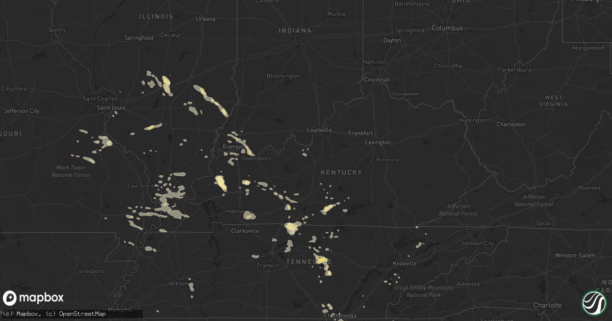
Hail Map in Kentucky on July 8, 2022
Get this storm
July 8 map
$229
one time, instant access
Download today. No call, no setup
Keep the $229
Bought the map and want the full workflow? Apply the entire $229 to a subscription within 7 days. None of it is wasted.
Every map, not just this one
This buys you this map. Subscription and you get every map we run, in the markets you choose from a few cities to whole states to nationwide. Plus real-time alerts the moment a storm fires.
Contact data
Name, contact info, occupancy, even credit band for addresses in the footprint. You go from where it hit to who to call.
Become the source they trust
Unlimited branding weather history reports on demand. You already have the documented answer ready for the property owner, and you are the one who showed up with it.
Property data and RoofTrace estimates
Pull up any address you have got, its value and the exact code rules for that jurisdiction, straight from One Click Code. Then RoofTrace estimates the squares, pitch, and roof value, priced the way you price.
Storm reports in Kentucky
Kentucky
| Date | Description |
|---|---|
| 07/08/20225:15 PM CDT | Reported a tree down on olmstead road off clarksville road. Time estimated from radar. |
| 07/08/20224:50 PM CDT | Reported a tree down on joe montgomery road off clarksville road. Time estimated from radar. |
| 07/08/20224:27 PM CDT | Call center reported one call from a driver who saw a tree fall off old glasgow road... Just off of hwy 98. It may have hit a structure there... But he was not certain. |
| 07/08/20223:42 PM CDT | Report from ky mesonet official of tree down on house on boatlanding rd. Time estimated from radar data. |
| 07/08/20223:15 PM CDT | Em reported major power outage across the county from multiple power lines and trees down. Time estimated from radar... For when the line went through morgantown. |
| 07/08/20223:10 PM CDT | Ema reports that they are closing hwy 738 in albany down due to 3 phase power lines and trees down on the roadway. Time estimated from radar. |
| 07/08/20222:49 PM CDT | Report of trees down in cumberland city... Ky. |
| 07/08/20222:44 PM CDT | Report of a tree that fell onto a powerline which fell onto a house along the 800 block of w 4th street in beaver dam... Ky. |
| 07/08/20222:35 PM CDT | Several tree tops broken off along haddox ferry road south of hwy 453. |
| 07/08/20222:30 PM CDT | Tree damage to a garage. Time estimated. |
| 07/08/20222:11 PM CDT | Reports of a couple trees down along cedar flat curtis rd and subtle rd. |
| 07/08/20225:06 AM CDT | At 1005 PM CDT, a severe thunderstorm was located near Olney, or 8 miles southwest of Providence, moving southeast at 15 mph. HAZARD...60 mph wind gusts and quarter size hail. SOURCE...Radar indicated. IMPACT...Hail damage to vehicles is expected. Expect wind damage to roofs, siding, and trees. This severe thunderstorm will be near... Olney around 1025 PM CDT.Other locations in the path of this severe thunderstorm includeDawson Springs.This includes Interstate 69 in Kentucky between Mile Markers 86 and94. |
| 07/08/20224:35 AM CDT | At 934 PM CDT, a severe thunderstorm was located near Clay, or near Providence, moving southeast at 15 mph. HAZARD...60 mph wind gusts and quarter size hail. SOURCE...Radar indicated. IMPACT...Hail damage to vehicles is expected. Expect wind damage to roofs, siding, and trees. Locations impacted include... Providence. |
| 07/08/20223:53 AM CDT | At 851 PM CDT, a severe thunderstorm was located over Chandler, moving southeast at 25 mph. HAZARD...60 mph wind gusts and quarter size hail. SOURCE...Radar indicated. IMPACT...Hail damage to vehicles is expected. Expect wind damage to roofs, siding, and trees. This severe thunderstorm will be near... Chandler around 855 PM CDT. Boonville and Newburgh around 905 PM CDT.This includes Interstate 69 in Indiana between Mile Markers 10 and11. |
| 07/08/20223:51 AM CDT | At 851 PM CDT, a severe thunderstorm was located over Chandler, moving southeast at 25 mph. HAZARD...60 mph wind gusts and quarter size hail. SOURCE...Radar indicated. IMPACT...Hail damage to vehicles is expected. Expect wind damage to roofs, siding, and trees. This severe thunderstorm will be near... Chandler around 855 PM CDT. Boonville and Newburgh around 905 PM CDT.This includes Interstate 69 in Indiana between Mile Markers 10 and11. |
| 07/08/202212:25 AM CDT | 1300 customers without power in calloway county. Also numerous trees down. |
| 07/08/202212:04 AM CDT | Tree limb down and corn flattened. Time estimated from radar. |
| 07/08/202212:01 AM CDT | Wall bowed in on a metal workshop. Time estimated from radar. |
| 07/07/202211:55 PM CDT | Trees down and corn flattened. Time estimated by radar. |
| 07/07/202211:55 PM CDT | At 455 PM CDT, a severe thunderstorm was located near Elkton, moving east at 20 mph. HAZARD...60 mph wind gusts and nickel size hail. SOURCE...Radar indicated. IMPACT...Expect damage to roofs, siding, and trees. This severe thunderstorm will remain over mainly rural areas of southeastern Todd County, including the following locations... Allensville. |
| 07/07/202211:38 PM CDT | At 438 PM CDT, a severe thunderstorm was located near Pembroke, or near Elkton, moving east at 20 mph. HAZARD...60 mph wind gusts and nickel size hail. SOURCE...Radar indicated. IMPACT...Expect damage to roofs, siding, and trees. This severe thunderstorm will be near... Elkton around 450 PM CDT. |
| 07/07/202211:08 PM CDT | At 407 PM CDT, a severe thunderstorm was located near Mount Victor, moving southeast at 25 mph. HAZARD...60 mph wind gusts and penny size hail. SOURCE...Radar indicated. IMPACT...Expect damage to roofs, siding, and trees. Locations impacted include... Scottsville. |
| 07/07/202210:39 PM CDT | At 339 PM CDT, a severe thunderstorm was located 9 miles southeast of Morgantown, moving southeast at 30 mph. HAZARD...60 mph wind gusts and penny size hail. SOURCE...Radar indicated. IMPACT...Expect damage to roofs, siding, and trees. Locations impacted include... Crestmoor, Plum Springs, Mount Victor and Bowling Green. |
| 07/07/202210:22 PM CDT | Large tree snapped. Time estimated from radar. |
| 07/07/202210:19 PM CDT | Large tree snapped off brookfield drive in paducah. Time estimated. |
| 07/07/202210:19 PM CDT | Large tree snapped by the ball fields in noble park. Time estimated from radar. |
| 07/07/202210:06 PM CDT | Tree uprooted. |
| 07/07/20229:58 PM CDT | At 258 PM CDT, a severe thunderstorm was located 10 miles west of Morgantown, moving east at 20 mph. HAZARD...60 mph wind gusts and penny size hail. SOURCE...Radar indicated. IMPACT...Expect damage to roofs, siding, and trees. Locations impacted include... Morgantown. |
| 07/07/20229:50 PM CDT | Large tree limbs down and a large tree was uprooted. Time estimated from radar. |
| 07/07/20229:34 PM CDT | At 234 PM CDT, a severe thunderstorm was located 8 miles south of Hartford, moving east at 20 mph. HAZARD...60 mph wind gusts and penny size hail. SOURCE...Radar indicated. IMPACT...Expect damage to roofs, siding, and trees. This severe thunderstorm will remain over mainly rural areas of northwestern Butler and southern Ohio Counties, including the following locations... Prentiss, Shultztown, Rochester, Centertown, Nineteen, Scottown, Cromwell, Logansport, Cool Springs and Pleasant Hill. |
| 07/07/20229:24 PM CDT | At 224 PM CDT, a severe thunderstorm was located near Graham, or 9 miles east of Madisonville, moving southeast at 25 mph. HAZARD...60 mph wind gusts and quarter size hail. SOURCE...Radar indicated. IMPACT...Hail damage to vehicles is expected. Expect wind damage to roofs, siding, and trees. This severe thunderstorm will be near... Graham around 235 PM CDT.This includes Western Kentucky Parkway between Mile Markers 43 and53. |
| 07/07/20229:11 PM CDT | At 211 PM CDT, a severe thunderstorm was located 9 miles southeast of Edmonton, moving east at 25 mph. HAZARD...60 mph wind gusts and quarter size hail. SOURCE...Radar indicated. IMPACT...Hail damage to vehicles is expected. Expect wind damage to roofs, siding, and trees. This severe thunderstorm will be near... Burkesville around 230 PM CDT. |
| 07/07/20228:19 PM CDT | At 119 PM CDT, a severe thunderstorm was located 12 miles east of Scottsville, moving east at 15 mph. HAZARD...60 mph wind gusts. SOURCE...Radar indicated. IMPACT...Expect damage to roofs, siding, and trees. This severe thunderstorm will remain over mainly rural areas of western Monroe, southern Allen and southeastern Barren Counties, including the following locations... Oak Forest, Gum Tree, Maynard, Gamaliel, Austin, Lamb, Alonzo, Flippin, Emberton and New Roe. |
All States Impacted by Hail Map on July 8, 2022
Cities Impacted by Hail Map on July 8, 2022
- Hilger, MT
- Box Elder, MT
- Havre, MT
- Sunburst, MT
- Valier, MT
- Hinsdale, MT
- Whitewater, MT
- Saco, MT
- Forsyth, MT
- Brusett, MT
- Ledger, MT
- Conrad, MT
- Shelby, MT
- Veteran, WY
- Yoder, WY
- Wheatland, WY
- Torrington, WY
- Harrison, NE
- Lingle, WY
- De Soto, MO
- Denton, MT
- Dodson, MT
- Malta, MT
- Gildford, MT
- Chinook, MT
- Hays, MT
- Harlem, MT
- Vergennes, IL
- Elkville, IL
- Cisne, IL
- Cimarron, NM
- Robards, KY
- Henderson, KY
- Bonne Terre, MO
- Ridgway, IL
- Junction, IL
- Edmond, OK
- Belknap, IL
- Fillmore, IL
- Irving, IL
- Alberton, MT
- Frenchtown, MT
- Missoula, MT
- Huson, MT
- Victor, MT
- Grand Junction, TN
- Hickory Valley, TN
- Eufaula, OK
- Canadian, OK
- Bowling Green, KY
- Oakland, KY
- Balko, OK
- Ekron, KY
- Vine Grove, KY
- Ava, IL
- Valles Mines, MO
- Rutledge, TN
- Pulaski, IL
- Broseley, MO
- Poplar Bluff, MO
- Essex, MO
- Parma, MO
- Dexter, MO
- Cairo, IL
- Obion, TN
- Ridgely, TN
- Gainesville, GA
- Galata, MT
- Oilmont, MT
- Chester, MT
- Whitlash, MT
- Joplin, MT
- Kevin, MT
- Bethalto, IL
- Magnolia, KY
- Summersville, KY
- Colorado Springs, CO
- Gillette, WY
- Douglas, WY
- Raton, NM
- Perryton, TX
- Stevensville, MT
- Clinton, MT
- Ovando, MT
- Choteau, MT
- Seeley Lake, MT
- Hamilton, MT
- Augusta, MT
- Lincoln, MT
- Corvallis, MT
- Bonner, MT
- Taloga, OK
- Akron, CO
- Shawmut, MT
- Judith Gap, MT
- Durham, OK
- Amarillo, TX
- East Helena, MT
- Clancy, MT
- Hillsboro, IL
- Cheyenne, WY
- Ashley, IL
- Oakdale, IL
- Nashville, IL
- Central City, KY
- Florissant, CO
- Penrose, CO
- Cottonwood, ID
- Imnaha, OR
- Ramsey, IL
- Vandalia, IL
- Bingham, IL
- Mulberry Grove, IL
- Evansville, IN
- Sparta, IL
- Baldwin, IL
- Hydro, OK
- Colony, OK
- Elgin, ND
- Almont, ND
- Glen Ullin, ND
- Carson, ND
- Louisville, IL
- Flora, IL
- Smiths Grove, KY
- Brownsville, KY
- Bigfork, MT
- Big Sandy, MT
- Inverness, MT
- Fort Benton, MT
- Hingham, MT
- Rudyard, MT
- Piedmont, SD
- Deadwood, SD
- Nemo, SD
- Jordan, MT
- Winnett, MT
- Roundup, MT
- Roy, MT
- Stanford, MT
- Helmville, MT
- Ravalli, MT
- Arlee, MT
- Philipsburg, MT
- Lewistown, MT
- Saint Ignatius, MT
- Charlo, MT
- Ronan, MT
- Charleston, MO
- Bertrand, MO
- Graham, KY
- Greenville, KY
- Walters, OK
- Oklahoma City, OK
- Atlanta, GA
- Canadian, TX
- Sikeston, MO
- Morgantown, KY
- Fritch, TX
- Cleveland, TN
- Granite, OK
- Castalian Springs, TN
- Lebanon, TN
- Mount Juliet, TN
- Gallatin, TN
- Fort Rucker, AL
- Piedmont, SC
- Easley, SC
- Dalton, GA
- Chatsworth, GA
- Turkey, TX
- Quitaque, TX
- Toomsboro, GA
- Hollis, OK
- Vinson, OK
- Salem, AL
- Levelland, TX
- Roaring Springs, TX
- Silverton, TX
- La Fayette, GA
- Sugar Valley, GA
- Resaca, GA
- Reynolds, GA
- Ideal, GA
- Butler, GA
- Wadley, AL
- Geary, OK
- Hinton, OK
- Sumner, IL
- Claremont, IL
- Evergreen, CO
- Unadilla, GA
- Elko, GA
- Hawkinsville, GA
- Arnett, OK
- Leedey, OK
- Crawford, OK
- Cheyenne, OK
- Bloomsdale, MO
- Festus, MO
- Mauk, GA
- Pine, CO
- Union City, OK
- El Reno, OK
- Newcastle, WY
- Upton, WY
- Roff, OK
- Allendale, IL
- Mount Carmel, IL
- Drummond, MT
- Spearman, TX
- Highland Home, AL
- Loring, MT
- Whitwell, TN
- Tracy City, TN
- Friendsville, TN
- Goodlettsville, TN
- Higgins, TX
- Columbia, KY
- Russell Springs, KY
- Smithville, TN
- Camilla, GA
- Wetumpka, AL
- Cordell, OK
- Sentinel, OK
- Carter, OK
- Lone Wolf, OK
- Dill City, OK
- Foss, OK
- Olney, IL
- Stinnett, TX
- Dawson Springs, KY
- Princeton, KY
- Mcminnville, TN
- Hastings, OK
- Waurika, OK
- Lafayette, AL
- McRae Helena, GA
- Alamo, GA
- Omaha, GA
- Pitts, GA
- Rochelle, GA
- Goshen, AL
- Grady, AL
- Luverne, AL
- Lapine, AL
- Ullin, IL
- Dundas, IL
- Newton, IL
- Ingraham, IL
- Calumet, OK
- Walling, TN
- Silver Point, TN
- Hickman, TN
- Sparta, TN
- Baxter, TN
- Lancaster, TN
- Quebeck, TN
- Hill City, SD
- Comanche, OK
- Bragg City, MO
- Holcomb, MO
- Drakesboro, KY
- Beaver Dam, KY
- Edmonton, KY
- Chestnut Mound, TN
- Buffalo Valley, TN
- Elmwood, TN
- Williamson, GA
- Zebulon, GA
- Conner, MT
- Sula, MT
- Darby, MT
- Texico, NM
- Farwell, TX
- Sylvania, GA
- Swainsboro, GA
- Providence, KY
- Clay, KY
- Marion, KY
- Dittmer, MO
- Lonedell, MO
- Grubville, MO
- Belleville, IL
- Millstadt, IL
- East Saint Louis, IL
- Custer, SD
- Goreville, IL
- Buncombe, IL
- Sturgis, KY
- Richland, IN
- Haubstadt, IN
- Rockport, IN
- Newburgh, IN
- Boonville, IN
- Cynthiana, IN
- Elberfeld, IN
- Chandler, IN
- Owensboro, KY
- Poseyville, IN
- Newbern, TN
- Wilkesboro, NC
- Boomer, NC
- Ferguson, NC
- Purlear, NC
- Cunningham, KY
- Kevil, KY
- Matthews, MO
- Luray, TN
- Jacks Creek, TN
- Huron, TN
- Reagan, TN
- Lexington, TN
- Knoxville, TN
- Corryton, TN
- Richburg, SC
- Arcadia, OK
- Potosi, MO
- Rumsey, KY
- Franklin, KY
- Scottsville, KY
- Bethel Springs, TN
- Finger, TN
- Enville, TN
- Allons, TN
- Chattanooga, TN
- Yukon, OK
- Greensburg, KY
- Lead, SD
- Sunray, TX
- Morse, TX
- New Madrid, MO
- Lilbourn, MO
- Catron, MO
- Marston, MO
- Wickliffe, KY
- Williston, SC
- Anderson, SC
- Central, SC
- Liberty, SC
- Williamston, SC
- Pendleton, SC
- North, SC
- Neeses, SC
- Flintstone, GA
- Fort Oglethorpe, GA
- Ringgold, GA
- Rock Spring, GA
- Rossville, GA
- Chickamauga, GA
- Albertville, AL
- Boaz, AL
- Crossville, AL
- Duncan, OK
- Abernathy, TX
- Shallowater, TX
- Ariton, AL
- New Brockton, AL
- Gould, OK
- Beaumont, KY
- Burkesville, KY
- Breeding, KY
- Summer Shade, KY
- Sacramento, KY
- Bremen, KY
- Doyle, TN
- Spencer, TN
- Rock Island, TN
- Shobonier, IL
- Maryville, TN
- Belgrade, MO
- Alvaton, KY
- Rockport, KY
- Tamms, IL
- Thompsonville, IL
- Macedonia, IL
- Bethpage, TN
- Westmoreland, TN
- Portland, TN
- Anna, IL
- Brownstown, IL
- Bloomfield, MO
- Nicholls, GA
- Eufaula, AL
- Barnesville, GA
- Meansville, GA
- Simpson, IL
- Healdton, OK
- Graham, OK
- Milan, GA
- Channing, TX
- Okarche, OK
- Union City, TN
- Hickman, KY
- Fulton, KY
- Anton, CO
- Arriba, CO
- Genoa, CO
- Lindon, CO
- Sequatchie, TN
- Louisville, GA
- Rupert, GA
- Bismarck, MO
- Ironton, MO
- Centertown, KY
- Fort Branch, IN
- Dowelltown, TN
- Jamestown, KY
- Albany, KY
- Greenback, TN
- Allensville, KY
- Trenton, KY
- Guthrie, KY
- Elkton, KY
- Pembroke, KY
- Hopkinsville, KY
- Livingston, TN
- East Prairie, MO
- Loco, OK
- Irondale, MO
- Caledonia, MO
- Rinard, IL
- Clay City, IL
- Johnsonville, IL
- Athens, TN
- Riceville, TN
- Toccoa, GA
- Blaine, TN
- Powder Springs, TN
- Washburn, TN
- Hilham, TN
- Celina, TN
- White Plains, KY
- Whitleyville, TN
- Red Boiling Springs, TN
- Pleasant Shade, TN
- Carthage, TN
- Booker, TX
- Adrian, GA
- Soperton, GA
- Madisonville, KY
- Bardwell, KY
- McLeansboro, IL
- Brandenburg, KY
- Panama, IL
- Sorento, IL
- Donnellson, IL
- Walshville, IL
- Norris City, IL
- Omaha, IL
- Cope, CO
- Cypress, IL
- Dongola, IL
- West Paducah, KY
- Paducah, KY
- Millers Creek, NC
- Gradyville, KY
- Mosquero, NM
- Miami, TX
- Morganton, GA
- Blairsville, GA
- Rhine, GA
- Abbeville, GA
- Millen, GA
- Vienna, IL
- Stonefort, IL
- Ozark, IL
- Kooskia, ID
- Stites, ID
- Davis, OK
- Adolphus, KY
- La Center, KY
- Mound City, IL
- Barlow, KY
- Hickory, KY
- Mayfield, KY
- Fancy Farm, KY
- Villa Ridge, IL
- Clinton, KY
- Grand Chain, IL
- Mounds, IL
- Arlington, KY
- Brookport, IL
- Metropolis, IL
- Greenville, IL
- Coffeen, IL
- Glens Fork, KY
- Cookeville, TN
- Tazewell, TN
- Jasper, TN
- Harrogate, TN
- Cumberland Gap, TN
- Pickens, SC
- Georgiana, AL
- Rebecca, GA
- Livermore, CO
- Corydon, KY
- Karnak, IL
- Sturgis, SD
- Marysville, MT
- Canyon Creek, MT
- Shields, ND
- Gainesboro, TN
- Clayton, NM
- Park Hills, MO
- Leadwood, MO
- Willow, OK
- Fountain Run, KY
- Moss, TN
- Goodwell, OK
- Texhoma, OK
- Forsyth, GA
- Trinidad, CO
- Guild, TN
- Gruver, TX
- Yemassee, SC
- Kellyton, AL
- Rockford, AL
- Ranger, GA
- Noble, IL
- Wheeler, IL
- Wildwood, GA
- Hayti, MO
- Wardell, MO
- Vonore, TN
- Philadelphia, TN
- Sweetwater, TN
- Loudon, TN
- Ramer, AL
- Mathews, AL
- Ellijay, GA
- Mill Creek, OK
- Wadley, GA
- Kinmundy, IL
- Saint Peter, IL
- Cowden, IL
- Brush Creek, TN
- Pocahontas, IL
- Roundhill, KY
- Jetson, KY
- Columbia, IL
- East Carondelet, IL
- Xenia, IL
- Muldraugh, KY
- Ozark, AL
- Hennepin, OK
- Wadesville, IN
- Calhoun, IL
- Dieterich, IL
- Saint Francisville, IL
- West Salem, IL
- Walhalla, SC
- Tamassee, SC
- Glasgow, KY
- Anniston, MO
- Columbus, KY
- Granville, TN
- Bloomington Springs, TN
- Fairview, TN
- Kingston Springs, TN
- White Bluff, TN
- Pegram, TN
- Lenoir, NC
- Granite Falls, NC
- Dahlonega, GA
- Childress, TX
- Salley, SC
- Summerville, GA
- Bailey, CO
- Conifer, CO
- Reed, KY
- Spottsville, KY
- Hartsville, TN
- Holland, KY
- Tompkinsville, KY
- Honoraville, AL
- Irwinton, GA
- Cut Bank, MT
- French Village, MO
- Union Mills, NC
- Rutherfordton, NC
- Hudson, NC
- Red Level, AL
- Cumming, GA
- Goodwater, AL
- Fairfax, SC
- Luray, SC
- Ridgeland, SC
- Coosawhatchie, SC
- Bessie, OK
- Great Falls, MT
- Cascade, MT
- Reserve, MT
- Larslan, MT
- Poplar, MT
- Wolf Point, MT
- Plentywood, MT
- Peerless, MT
- Zortman, MT
- Dagmar, MT
- Scobey, MT
- Nashua, MT
- Saint Marie, MT
- Grenora, ND
- Westby, MT
- Glasgow, MT
- Redstone, MT
- Frazer, MT
- Winifred, MT
- Fort Peck, MT
- Outlook, MT
- Antelope, MT
- Flaxville, MT
- Fort Laramie, WY


