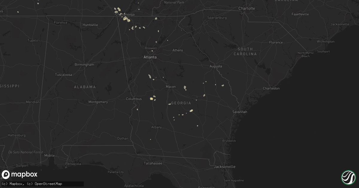
Hail Map in Georgia on July 8, 2022
Get this storm
July 8 map
$229
one time, instant access
Download today. No call, no setup
Keep the $229
Bought the map and want the full workflow? Apply the entire $229 to a subscription within 7 days. None of it is wasted.
Every map, not just this one
This buys you this map. Subscription and you get every map we run, in the markets you choose from a few cities to whole states to nationwide. Plus real-time alerts the moment a storm fires.
Contact data
Name, contact info, occupancy, even credit band for addresses in the footprint. You go from where it hit to who to call.
Become the source they trust
Unlimited branding weather history reports on demand. You already have the documented answer ready for the property owner, and you are the one who showed up with it.
Property data and RoofTrace estimates
Pull up any address you have got, its value and the exact code rules for that jurisdiction, straight from One Click Code. Then RoofTrace estimates the squares, pitch, and roof value, priced the way you price.
Storm reports in Georgia
Georgia
| Date | Description |
|---|---|
| 07/08/20226:45 PM CDT | Tree and powerlines reported down near the intersection of wheeler rd and gordon st. |
| 07/08/20225:05 PM CDT | Tree down on powerline along souter road. |
| 07/08/20224:05 PM CDT | Tree down on milan cemetery rd at temperance rd |
| 07/08/20223:12 PM CDT | Tree down at orianna and georgia hwy 15 |
| 07/08/20223:02 PM CDT | Tree down at norris rd and crooked run rd |
| 07/08/20222:41 PM CDT | Two reports of trees down in dublin. One tree down near intersection of telfair st and grady st. |
| 07/08/20225:04 AM CDT | At 1004 PM EDT, a severe thunderstorm was located over Doraville, or 8 miles north of Decatur, moving southeast at 20 mph. HAZARD...60 mph wind gusts and quarter size hail. SOURCE...Radar indicated. IMPACT...Hail damage to vehicles is expected. Expect wind damage to roofs, siding, and trees. Locations impacted include... Decatur, Sandy Springs, Dunwoody, Lilburn, Chamblee, Norcross, Doraville, Clarkston, Stone Mountain, Avondale Estates, Pine Lake, Tucker, Belvedere Park, North Decatur, North Atlanta, Candler-Mcafee, North Druid Hills, Druid Hills, Mountain Park and Belmont. |
| 07/08/20224:26 AM CDT | At 926 PM EDT, severe thunderstorms were located along a line extending from Ball Ground to near Buffington to Lebanon, moving southeast at 30 mph. HAZARD...60 mph wind gusts. SOURCE...Radar indicated. IMPACT...Expect damage to roofs, siding, and trees. Locations impacted include... Canton, Cumming, Sandy Springs, Roswell, Alpharetta, Milton, Woodstock, Holly Springs, Ball Ground, Free Home, Buffington, Hickory Flat, Drew, Hightower, Matt, Lathemtown, Hobgood Park, Union Hill, Sweat Mountain and Birmingham. |
| 07/08/20222:52 AM CDT | At 751 PM EDT, a severe thunderstorm was located near Hemp, or 9 miles west of Blairsville, moving southeast at 10 mph. HAZARD...60 mph wind gusts and quarter size hail. SOURCE...Radar indicated. IMPACT...Hail damage to vehicles is expected. Expect wind damage to roofs, siding, and trees. Locations impacted include... Blairsville, Hemp, Nottely Dam, Ivy Log, Loving and Jones Creek. |
| 07/08/20222:32 AM CDT | At 732 PM EDT, a severe thunderstorm was located 11 miles south of Newton, moving south at 10 mph. HAZARD...60 mph wind gusts and nickel size hail. SOURCE...Radar indicated. IMPACT...Expect damage to roofs, siding, and trees. Locations impacted include... Vada, Hoggard Mill, Branchville, Hopeful and Harrells Still. |
| 07/08/202212:43 AM CDT | At 543 PM EDT, severe thunderstorms were located along a line extending from near Arabi to 9 miles southeast of Rochelle, moving southeast at 10 mph. HAZARD...60 mph wind gusts and penny size hail. SOURCE...Radar indicated. IMPACT...Expect damage to roofs, siding, and trees. Locations impacted include... Fitzgerald, Ashburn, Worth, Terrell, Sycamore, Rebecca, Lulaville, Amboy, Sibley, Inaha, Coverdale, Irwinville, Fitzgerald Municipal A/P, Hobby, Turner Co Airport, Irwinville Airport, Bowens Mill, Dakota, Doles and Arp. |
| 07/08/202212:00 AM CDT | At 500 PM EDT, severe thunderstorms were located along a line extending from near Antioch Church to near Milan to near Little Ocmulgee State Park, moving east at 10 mph. HAZARD...60 mph wind gusts and penny size hail. SOURCE...Radar indicated. IMPACT...Expect damage to roofs, siding, and trees. Locations impacted include... McRae, Abbeville, Alamo, Helena, Rochelle, Milan, Rhine, Scotland, Antioch Church, Temperance, Browning, Little Ocmulgee State Park and Workmore. |
| 07/07/202211:01 PM CDT | At 401 PM EDT, severe thunderstorms were located along a line extending from Norristown to Covena to near Swainsboro, moving east at 5 mph. HAZARD...60 mph wind gusts and penny size hail. SOURCE...Radar indicated. IMPACT...Expect damage to roofs, siding, and trees. Locations impacted include... Swainsboro, Twin City, Stillmore, Oak Park, Nunez, Covena, Lexsy, Norristown, George L Smith State Park and Gillis Springs. |
| 07/07/202210:46 PM CDT | At 346 PM EDT, a severe thunderstorm was located over East Dublin, or over Dublin, moving east at 20 mph. HAZARD...60 mph wind gusts and penny size hail. SOURCE...Radar indicated. IMPACT...Expect damage to roofs, siding, and trees. Locations impacted include... Dublin, Soperton, East Dublin, Adrian, Lothair, Orland, Rockledge, Orianna, Barnhill, Minter, Harlow, Brewton, Blackville and Scott. |
| 07/07/202210:32 PM CDT | At 331 PM EDT, a severe thunderstorm was located over Charing, or 8 miles southwest of Butler, moving east at 5 mph. HAZARD...60 mph wind gusts and penny size hail. SOURCE...Radar indicated. IMPACT...Expect damage to roofs, siding, and trees. Locations impacted include... Butler, Ideal, Rupert, Charing and Mauk. |
| 07/07/20229:30 PM CDT | Tree reported down on prince ave between n milledge ave to n chase st. |
| 07/07/20228:39 PM CDT | Over a dozen trees down and extensive... Tree related... Structural damage in neighborhood of victoria station |
| 07/07/20228:24 PM CDT | Tree down at sequoyah circle |
| 07/07/20228:16 PM CDT | Multiple trees and powerlines down. |
| 07/07/20227:29 PM CDT | Multiple trees down around carter's dam |
| 07/07/20227:15 PM CDT | Tree down on independent street. |
All States Impacted by Hail Map on July 8, 2022
Cities Impacted by Hail Map on July 8, 2022
- Hilger, MT
- Box Elder, MT
- Havre, MT
- Sunburst, MT
- Valier, MT
- Hinsdale, MT
- Whitewater, MT
- Saco, MT
- Forsyth, MT
- Brusett, MT
- Ledger, MT
- Conrad, MT
- Shelby, MT
- Veteran, WY
- Yoder, WY
- Wheatland, WY
- Torrington, WY
- Harrison, NE
- Lingle, WY
- De Soto, MO
- Denton, MT
- Dodson, MT
- Malta, MT
- Gildford, MT
- Chinook, MT
- Hays, MT
- Harlem, MT
- Vergennes, IL
- Elkville, IL
- Cisne, IL
- Cimarron, NM
- Robards, KY
- Henderson, KY
- Bonne Terre, MO
- Ridgway, IL
- Junction, IL
- Edmond, OK
- Belknap, IL
- Fillmore, IL
- Irving, IL
- Alberton, MT
- Frenchtown, MT
- Missoula, MT
- Huson, MT
- Victor, MT
- Grand Junction, TN
- Hickory Valley, TN
- Eufaula, OK
- Canadian, OK
- Bowling Green, KY
- Oakland, KY
- Balko, OK
- Ekron, KY
- Vine Grove, KY
- Ava, IL
- Valles Mines, MO
- Rutledge, TN
- Pulaski, IL
- Broseley, MO
- Poplar Bluff, MO
- Essex, MO
- Parma, MO
- Dexter, MO
- Cairo, IL
- Obion, TN
- Ridgely, TN
- Gainesville, GA
- Galata, MT
- Oilmont, MT
- Chester, MT
- Whitlash, MT
- Joplin, MT
- Kevin, MT
- Bethalto, IL
- Magnolia, KY
- Summersville, KY
- Colorado Springs, CO
- Gillette, WY
- Douglas, WY
- Raton, NM
- Perryton, TX
- Stevensville, MT
- Clinton, MT
- Ovando, MT
- Choteau, MT
- Seeley Lake, MT
- Hamilton, MT
- Augusta, MT
- Lincoln, MT
- Corvallis, MT
- Bonner, MT
- Taloga, OK
- Akron, CO
- Shawmut, MT
- Judith Gap, MT
- Durham, OK
- Amarillo, TX
- East Helena, MT
- Clancy, MT
- Hillsboro, IL
- Cheyenne, WY
- Ashley, IL
- Oakdale, IL
- Nashville, IL
- Central City, KY
- Florissant, CO
- Penrose, CO
- Cottonwood, ID
- Imnaha, OR
- Ramsey, IL
- Vandalia, IL
- Bingham, IL
- Mulberry Grove, IL
- Evansville, IN
- Sparta, IL
- Baldwin, IL
- Hydro, OK
- Colony, OK
- Elgin, ND
- Almont, ND
- Glen Ullin, ND
- Carson, ND
- Louisville, IL
- Flora, IL
- Smiths Grove, KY
- Brownsville, KY
- Bigfork, MT
- Big Sandy, MT
- Inverness, MT
- Fort Benton, MT
- Hingham, MT
- Rudyard, MT
- Piedmont, SD
- Deadwood, SD
- Nemo, SD
- Jordan, MT
- Winnett, MT
- Roundup, MT
- Roy, MT
- Stanford, MT
- Helmville, MT
- Ravalli, MT
- Arlee, MT
- Philipsburg, MT
- Lewistown, MT
- Saint Ignatius, MT
- Charlo, MT
- Ronan, MT
- Charleston, MO
- Bertrand, MO
- Graham, KY
- Greenville, KY
- Walters, OK
- Oklahoma City, OK
- Atlanta, GA
- Canadian, TX
- Sikeston, MO
- Morgantown, KY
- Fritch, TX
- Cleveland, TN
- Granite, OK
- Castalian Springs, TN
- Lebanon, TN
- Mount Juliet, TN
- Gallatin, TN
- Fort Rucker, AL
- Piedmont, SC
- Easley, SC
- Dalton, GA
- Chatsworth, GA
- Turkey, TX
- Quitaque, TX
- Toomsboro, GA
- Hollis, OK
- Vinson, OK
- Salem, AL
- Levelland, TX
- Roaring Springs, TX
- Silverton, TX
- La Fayette, GA
- Sugar Valley, GA
- Resaca, GA
- Reynolds, GA
- Ideal, GA
- Butler, GA
- Wadley, AL
- Geary, OK
- Hinton, OK
- Sumner, IL
- Claremont, IL
- Evergreen, CO
- Unadilla, GA
- Elko, GA
- Hawkinsville, GA
- Arnett, OK
- Leedey, OK
- Crawford, OK
- Cheyenne, OK
- Bloomsdale, MO
- Festus, MO
- Mauk, GA
- Pine, CO
- Union City, OK
- El Reno, OK
- Newcastle, WY
- Upton, WY
- Roff, OK
- Allendale, IL
- Mount Carmel, IL
- Drummond, MT
- Spearman, TX
- Highland Home, AL
- Loring, MT
- Whitwell, TN
- Tracy City, TN
- Friendsville, TN
- Goodlettsville, TN
- Higgins, TX
- Columbia, KY
- Russell Springs, KY
- Smithville, TN
- Camilla, GA
- Wetumpka, AL
- Cordell, OK
- Sentinel, OK
- Carter, OK
- Lone Wolf, OK
- Dill City, OK
- Foss, OK
- Olney, IL
- Stinnett, TX
- Dawson Springs, KY
- Princeton, KY
- Mcminnville, TN
- Hastings, OK
- Waurika, OK
- Lafayette, AL
- McRae Helena, GA
- Alamo, GA
- Omaha, GA
- Pitts, GA
- Rochelle, GA
- Goshen, AL
- Grady, AL
- Luverne, AL
- Lapine, AL
- Ullin, IL
- Dundas, IL
- Newton, IL
- Ingraham, IL
- Calumet, OK
- Walling, TN
- Silver Point, TN
- Hickman, TN
- Sparta, TN
- Baxter, TN
- Lancaster, TN
- Quebeck, TN
- Hill City, SD
- Comanche, OK
- Bragg City, MO
- Holcomb, MO
- Drakesboro, KY
- Beaver Dam, KY
- Edmonton, KY
- Chestnut Mound, TN
- Buffalo Valley, TN
- Elmwood, TN
- Williamson, GA
- Zebulon, GA
- Conner, MT
- Sula, MT
- Darby, MT
- Texico, NM
- Farwell, TX
- Sylvania, GA
- Swainsboro, GA
- Providence, KY
- Clay, KY
- Marion, KY
- Dittmer, MO
- Lonedell, MO
- Grubville, MO
- Belleville, IL
- Millstadt, IL
- East Saint Louis, IL
- Custer, SD
- Goreville, IL
- Buncombe, IL
- Sturgis, KY
- Richland, IN
- Haubstadt, IN
- Rockport, IN
- Newburgh, IN
- Boonville, IN
- Cynthiana, IN
- Elberfeld, IN
- Chandler, IN
- Owensboro, KY
- Poseyville, IN
- Newbern, TN
- Wilkesboro, NC
- Boomer, NC
- Ferguson, NC
- Purlear, NC
- Cunningham, KY
- Kevil, KY
- Matthews, MO
- Luray, TN
- Jacks Creek, TN
- Huron, TN
- Reagan, TN
- Lexington, TN
- Knoxville, TN
- Corryton, TN
- Richburg, SC
- Arcadia, OK
- Potosi, MO
- Rumsey, KY
- Franklin, KY
- Scottsville, KY
- Bethel Springs, TN
- Finger, TN
- Enville, TN
- Allons, TN
- Chattanooga, TN
- Yukon, OK
- Greensburg, KY
- Lead, SD
- Sunray, TX
- Morse, TX
- New Madrid, MO
- Lilbourn, MO
- Catron, MO
- Marston, MO
- Wickliffe, KY
- Williston, SC
- Anderson, SC
- Central, SC
- Liberty, SC
- Williamston, SC
- Pendleton, SC
- North, SC
- Neeses, SC
- Flintstone, GA
- Fort Oglethorpe, GA
- Ringgold, GA
- Rock Spring, GA
- Rossville, GA
- Chickamauga, GA
- Albertville, AL
- Boaz, AL
- Crossville, AL
- Duncan, OK
- Abernathy, TX
- Shallowater, TX
- Ariton, AL
- New Brockton, AL
- Gould, OK
- Beaumont, KY
- Burkesville, KY
- Breeding, KY
- Summer Shade, KY
- Sacramento, KY
- Bremen, KY
- Doyle, TN
- Spencer, TN
- Rock Island, TN
- Shobonier, IL
- Maryville, TN
- Belgrade, MO
- Alvaton, KY
- Rockport, KY
- Tamms, IL
- Thompsonville, IL
- Macedonia, IL
- Bethpage, TN
- Westmoreland, TN
- Portland, TN
- Anna, IL
- Brownstown, IL
- Bloomfield, MO
- Nicholls, GA
- Eufaula, AL
- Barnesville, GA
- Meansville, GA
- Simpson, IL
- Healdton, OK
- Graham, OK
- Milan, GA
- Channing, TX
- Okarche, OK
- Union City, TN
- Hickman, KY
- Fulton, KY
- Anton, CO
- Arriba, CO
- Genoa, CO
- Lindon, CO
- Sequatchie, TN
- Louisville, GA
- Rupert, GA
- Bismarck, MO
- Ironton, MO
- Centertown, KY
- Fort Branch, IN
- Dowelltown, TN
- Jamestown, KY
- Albany, KY
- Greenback, TN
- Allensville, KY
- Trenton, KY
- Guthrie, KY
- Elkton, KY
- Pembroke, KY
- Hopkinsville, KY
- Livingston, TN
- East Prairie, MO
- Loco, OK
- Irondale, MO
- Caledonia, MO
- Rinard, IL
- Clay City, IL
- Johnsonville, IL
- Athens, TN
- Riceville, TN
- Toccoa, GA
- Blaine, TN
- Powder Springs, TN
- Washburn, TN
- Hilham, TN
- Celina, TN
- White Plains, KY
- Whitleyville, TN
- Red Boiling Springs, TN
- Pleasant Shade, TN
- Carthage, TN
- Booker, TX
- Adrian, GA
- Soperton, GA
- Madisonville, KY
- Bardwell, KY
- McLeansboro, IL
- Brandenburg, KY
- Panama, IL
- Sorento, IL
- Donnellson, IL
- Walshville, IL
- Norris City, IL
- Omaha, IL
- Cope, CO
- Cypress, IL
- Dongola, IL
- West Paducah, KY
- Paducah, KY
- Millers Creek, NC
- Gradyville, KY
- Mosquero, NM
- Miami, TX
- Morganton, GA
- Blairsville, GA
- Rhine, GA
- Abbeville, GA
- Millen, GA
- Vienna, IL
- Stonefort, IL
- Ozark, IL
- Kooskia, ID
- Stites, ID
- Davis, OK
- Adolphus, KY
- La Center, KY
- Mound City, IL
- Barlow, KY
- Hickory, KY
- Mayfield, KY
- Fancy Farm, KY
- Villa Ridge, IL
- Clinton, KY
- Grand Chain, IL
- Mounds, IL
- Arlington, KY
- Brookport, IL
- Metropolis, IL
- Greenville, IL
- Coffeen, IL
- Glens Fork, KY
- Cookeville, TN
- Tazewell, TN
- Jasper, TN
- Harrogate, TN
- Cumberland Gap, TN
- Pickens, SC
- Georgiana, AL
- Rebecca, GA
- Livermore, CO
- Corydon, KY
- Karnak, IL
- Sturgis, SD
- Marysville, MT
- Canyon Creek, MT
- Shields, ND
- Gainesboro, TN
- Clayton, NM
- Park Hills, MO
- Leadwood, MO
- Willow, OK
- Fountain Run, KY
- Moss, TN
- Goodwell, OK
- Texhoma, OK
- Forsyth, GA
- Trinidad, CO
- Guild, TN
- Gruver, TX
- Yemassee, SC
- Kellyton, AL
- Rockford, AL
- Ranger, GA
- Noble, IL
- Wheeler, IL
- Wildwood, GA
- Hayti, MO
- Wardell, MO
- Vonore, TN
- Philadelphia, TN
- Sweetwater, TN
- Loudon, TN
- Ramer, AL
- Mathews, AL
- Ellijay, GA
- Mill Creek, OK
- Wadley, GA
- Kinmundy, IL
- Saint Peter, IL
- Cowden, IL
- Brush Creek, TN
- Pocahontas, IL
- Roundhill, KY
- Jetson, KY
- Columbia, IL
- East Carondelet, IL
- Xenia, IL
- Muldraugh, KY
- Ozark, AL
- Hennepin, OK
- Wadesville, IN
- Calhoun, IL
- Dieterich, IL
- Saint Francisville, IL
- West Salem, IL
- Walhalla, SC
- Tamassee, SC
- Glasgow, KY
- Anniston, MO
- Columbus, KY
- Granville, TN
- Bloomington Springs, TN
- Fairview, TN
- Kingston Springs, TN
- White Bluff, TN
- Pegram, TN
- Lenoir, NC
- Granite Falls, NC
- Dahlonega, GA
- Childress, TX
- Salley, SC
- Summerville, GA
- Bailey, CO
- Conifer, CO
- Reed, KY
- Spottsville, KY
- Hartsville, TN
- Holland, KY
- Tompkinsville, KY
- Honoraville, AL
- Irwinton, GA
- Cut Bank, MT
- French Village, MO
- Union Mills, NC
- Rutherfordton, NC
- Hudson, NC
- Red Level, AL
- Cumming, GA
- Goodwater, AL
- Fairfax, SC
- Luray, SC
- Ridgeland, SC
- Coosawhatchie, SC
- Bessie, OK
- Great Falls, MT
- Cascade, MT
- Reserve, MT
- Larslan, MT
- Poplar, MT
- Wolf Point, MT
- Plentywood, MT
- Peerless, MT
- Zortman, MT
- Dagmar, MT
- Scobey, MT
- Nashua, MT
- Saint Marie, MT
- Grenora, ND
- Westby, MT
- Glasgow, MT
- Redstone, MT
- Frazer, MT
- Winifred, MT
- Fort Peck, MT
- Outlook, MT
- Antelope, MT
- Flaxville, MT
- Fort Laramie, WY


