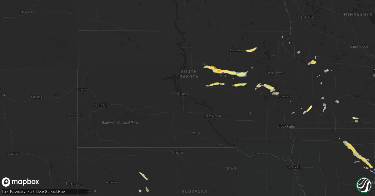
Hail Map in South Dakota on July 6, 2024
Get this storm
July 6 map
$229
one time, instant access
Download today. No call, no setup
Keep the $229
Bought the map and want the full workflow? Apply the entire $229 to a subscription within 7 days. None of it is wasted.
Every map, not just this one
This buys you this map. Subscription and you get every map we run, in the markets you choose from a few cities to whole states to nationwide. Plus real-time alerts the moment a storm fires.
Contact data
Name, contact info, occupancy, even credit band for addresses in the footprint. You go from where it hit to who to call.
Become the source they trust
Unlimited branding weather history reports on demand. You already have the documented answer ready for the property owner, and you are the one who showed up with it.
Property data and RoofTrace estimates
Pull up any address you have got, its value and the exact code rules for that jurisdiction, straight from One Click Code. Then RoofTrace estimates the squares, pitch, and roof value, priced the way you price.
Storm reports in South Dakota
South Dakota
| Date | Description |
|---|---|
| 07/06/20245:48 PM CDT | Received a public |
| 07/06/20245:48 PM CDT | Received a public report of quarter size. Time was estimated using radar. |
| 07/06/20245:17 PM CDT | Report from mping. 1-inch tree limbs broken. |
| 07/06/20245:17 PM CDT | Nickel to quarter sized hail on highway 28 at the clark and hamlin county line. |
| 07/06/20244:50 PM CDT | A few tree branches down with pea sized hail. |
| 07/06/20244:45 PM CDT | Via facebook. |
| 07/06/20244:43 PM CDT | Via facebook. |
| 07/06/20244:15 PM CDT | Groton police reported quarter sized hail in town. |
| 07/06/20243:57 PM CDT | Numerous tree branches down in down. Leaves taken off trees due to the combination of the wind and 0.5 inch hail that covered the ground. |
| 07/06/20243:35 PM CDT | Awos station k1d8 redfield muni ap. |
| 07/06/20243:35 PM CDT | Tree branches and powerlines down in redfield. Quarter sized hail also reported. Via facebook. |
| 07/06/20243:20 PM CDT | Quarter sized hail and estimated 50 mph winds. Had some tree damage. Via facebook. |
| 07/06/20243:07 PM CDT | Dime to quarter sized hail at lake louise state park. |
| 07/06/20243:00 PM CDT | Via facebook. |
| 07/06/20242:48 PM CDT | Mesonet station 158 miranda |
| 07/06/20242:27 PM CDT | Hail of quarter to golf ball sized... Which produced crop damage. 1.5 inches of rain fell. |
All States Impacted by Hail Map on July 6, 2024
Cities Impacted by Hail Map on July 6, 2024
- Sutherland, NE
- Hershey, NE
- North Platte, NE
- Nome, ND
- Enderlin, ND
- Maxwell, NE
- Brady, NE
- Gothenburg, NE
- Buchanan, ND
- Stapleton, NE
- Willow Island, NE
- Cozad, NE
- Lexington, NE
- Arnold, NE
- Elwood, NE
- Westby, MT
- Brockton, MT
- Overton, NE
- Eddyville, NE
- Bertrand, NE
- Smithfield, NE
- Lidgerwood, ND
- Wyndmere, ND
- Merna, NE
- Anselmo, NE
- Lebanon, SD
- Broken Bow, NE
- Callaway, NE
- Eustis, NE
- Franklin, GA
- Roanoke, AL
- Elm Creek, NE
- Seneca, SD
- Sylacauga, AL
- Clanton, AL
- Tolstoy, SD
- Cohasset, MN
- Loomis, NE
- Holdrege, NE
- Pelion, SC
- Herndon, KS
- Ludell, KS
- Faulkton, SD
- Kearney, NE
- Funk, NE
- Brewster, KS
- Atwood, KS
- Angora, MN
- Britt, MN
- Carrollton, GA
- Onaka, SD
- Oberlin, KS
- Levant, KS
- Axtell, NE
- Marshville, NC
- Wellfleet, NE
- Houston, TX
- Cook, MN
- Sumner, NE
- Hayes Center, NE
- Orient, SD
- Maywood, NE
- Palmetto, GA
- Colby, KS
- Oconto, NE
- Granada, MN
- Truman, MN
- Sisseton, SD
- Minden, NE
- Douglasville, GA
- New Effington, SD
- Newnan, GA
- Winnebago, MN
- Selden, KS
- Highmore, SD
- Pearland, TX
- Heartwell, NE
- Albemarle, NC
- Ree Heights, SD
- Isabella, MN
- Oakley, KS
- Curtis, NE
- Rockham, SD
- Hockley, TX
- Fresno, TX
- Jennings, KS
- Holabird, SD
- Waller, TX
- Miller, SD
- Katy, TX
- Rugby, ND
- Hitchcock, SD
- Redfield, SD
- Rexford, KS
- Moorefield, NE
- Stockville, NE
- Norcatur, KS
- New London, NC
- Hoxie, KS
- Clayton, KS
- Norton, KS
- Farnam, NE
- Dumont, MN
- Poplar, MT
- Kenesaw, NE
- Dresden, KS
- Atlanta, NE
- Indianola, NE
- Bartley, NE
- Cambridge, NE
- Saint Lawrence, SD
- Grinnell, KS
- Kettle River, MN
- Lenora, KS
- Cotton, MN
- Makinen, MN
- Monument, KS
- Mason, TX
- Fredericksburg, TX
- Hildreth, NE
- Juniata, NE
- Grainfield, KS
- Wood River, NE
- Wilcox, NE
- Wheaton, MN
- Bethune, SC
- Winona, KS
- Llano, TX
- Holstein, NE
- Almena, KS
- Logan, KS
- Prairie View, KS
- Brimson, MN
- Silverstreet, SC
- Kinards, SC
- Gove, KS
- Park, KS
- Gibbon, NE
- Frankfort, SD
- Lyons, GA
- Hastings, NE
- Doniphan, NE
- Forsyth, GA
- Doland, SD
- Clinton, SC
- Juliette, GA
- Quinter, KS
- Eveleth, MN
- Groton, SD
- Upland, NE
- Castell, TX
- Jackson, GA
- Humboldt, IA
- Campbell, NE
- Andover, SD
- Iroquois, SD
- Roseland, NE
- Ortonville, MN
- Willow Lake, SD
- Livermore, IA
- Hardy, IA
- Riverton, NE
- Bladen, NE
- Saco, MT
- Ayr, NE
- Glenvil, NE
- Trumbull, NE
- Inland, NE
- Blue Hill, NE
- Red Cloud, NE
- Harvard, NE
- Guide Rock, NE
- Lawrence, NE
- Fairfield, NE
- Healy, KS
- Collyer, KS
- Raymond, SD
- Thor, IA
- Ruthven, IA
- Graettinger, IA
- Emmetsburg, IA
- Pierpont, SD
- Clinton, MN
- Apex, NC
- Holly Springs, NC
- Crescent, IA
- Clark, SD
- Goldfield, IA
- Superior, NE
- Nelson, NE
- Deweese, NE
- Clay Center, NE
- Edgar, NE
- Saronville, NE
- Oak, NE
- Utica, KS
- Dighton, KS
- Eagle Grove, IA
- Stanley, ND
- Cylinder, IA
- Raleigh, NC
- Cary, NC
- Underwood, IA
- Chokio, MN
- Fort Peck, MT
- Bryant, SD
- Erwin, SD
- Lake Norden, SD
- Lake Preston, SD
- Biwabik, MN
- Scott City, KS
- Whittemore, IA
- West Bend, IA
- Aurora, MN
- Kershaw, SC
- San Saba, TX
- New Hill, NC
- Blue Earth, MN
- Algona, IA
- Ottosen, IA
- Bode, IA
- Ruskin, NE
- Davenport, NE
- Shickley, NE
- Sutton, NE
- Ong, NE
- Hebron, NE
- Carleton, NE
- Deshler, NE
- Grafton, NE
- Strang, NE
- Geneva, NE
- Bruning, NE
- Fairmont, NE
- Neola, IA
- Wesson, MS
- Gilbert, MN
- Arlington, SD
- Rutland, IA
- Minden, IA
- Goldthwaite, TX
- East Dublin, GA
- Letcher, SD
- Beeler, KS
- Arnold, KS
- Ransom, KS
- Ness City, KS
- Badger, SD
- Belvidere, NE
- Ohiowa, NE
- Exeter, NE
- Milligan, NE
- Tobias, NE
- Alexandria, NE
- Fairbury, NE
- Gilead, NE
- Daykin, NE
- Mullin, TX
- Marienthal, KS
- Shelby, IA
- Persia, IA
- Panhandle, TX
- Robert Lee, TX
- Delavan, MN
- Amarillo, TX
- Milan, MN
- Avoca, IA
- Hancock, IA
- Harlan, IA
- Pleasanton, NE
- Talpa, TX
- Lometa, TX
- Lawn, TX
- Ovalo, TX
- Santa Anna, TX
- Papillion, NE
- Omaha, NE
- McDade, TX
- Friend, NE
- Jansen, NE
- Plymouth, NE
- Swanton, NE
- Western, NE
- Wilber, NE
- Crete, NE
- Milford, NE
- Dorchester, NE
- De Witt, NE
- Bruce, SD
- Volga, SD
- Benson, MN
- Appleton, MN
- Echo, MN
- Wood Lake, MN
- Danvers, MN
- Tuscola, TX
- Abilene, TX
- Montevideo, MN
- Ravenna, NE
- Coleman, TX
- Dakota City, IA
- Claude, TX
- Clarion, IA
- Merriman, NE
- Valera, TX
- Oakland, IA
- Vincent, IA
- Spring Hope, NC
- Nashville, NC
- Woolstock, IA
- Martell, NE
- Hallam, NE
- Beatrice, NE
- Denton, NE
- Firth, NE
- Pickrell, NE
- Cortland, NE
- Clatonia, NE
- Pleasant Dale, NE
- Adams, NE
- Roca, NE
- Hickman, NE
- Sprague, NE
- Granite Falls, MN
- Silver City, IA
- Malvern, IA
- Gillett, TX
- Haxtun, CO
- Pacific Junction, IA
- Webster City, IA
- Bazine, KS
- Cimarron, KS
- Brownwood, TX
- Clare, IA
- Hyannis, NE
- Castalia, NC
- Glenwood, IA
- Elkton, SD
- Raymond, MN
- Clara City, MN
- Hastings, IA
- Henderson, IA
- Paoli, CO
- Holyoke, CO
- Alexander, KS
- Stockdale, TX
- Tulare, SD
- Maynard, MN
- Jetmore, KS
- Groom, TX
- Wray, CO
- Jasper, MN
- Trent, SD
- Harmony, NC
- Olin, NC
- Badger, IA
- Edgerton, MN
- Chandler, MN
- Prinsburg, MN
- Blairsburg, IA
- Emerson, IA
- Burdett, KS
- Rozel, KS
- Canyon, TX
- Lake Wilson, MN
- Slayton, MN
- Duncombe, IA
- Macedonia, IA
- Griswold, IA
- Red Oak, IA
- Carson, IA
- Union Grove, NC
- Hamptonville, NC
- Jewell, IA
- Kamrar, IA
- Garden City, KS
- Frazer, MT
- Springfield, MN
- Wayside, TX
- Pipestone, MN
- Hanston, KS
- Kinsley, KS
- Fulda, MN
- Ellsworth, IA
- Comfrey, MN
- Wright, KS
- Dodge City, KS
- Spearville, KS
- Radcliffe, IA
- Westbrook, MN
- Walnut Grove, MN
- Storden, MN
- Hubbard, IA
- Seneca, KS
- Roland, IA
- Revere, MN
- Happy, TX
- Tulia, TX
- Ingalls, KS
- Pierceville, KS
- McCallsburg, IA
- Zearing, IA
- Saint Anthony, IA
- New Providence, IA
- Clemons, IA
- Ashby, NE
- Whitman, NE
- Montezuma, KS
- Copeland, KS
- Union, IA
- Marshalltown, IA
- Albion, IA
- Ensign, KS
- Meade, KS
- Fowler, KS
- Carter Lake, IA
- Plains, KS
- Tabor, IA
- Council Bluffs, IA
- Springfield, NE
- Leoti, KS
- Deerfield, KS
- Holcomb, KS
- Leesville, SC
- Salley, SC
- Englewood, KS
- Minneola, KS
- Hasty, CO
- Oshkosh, NE
- Lamar, CO
- Bricelyn, MN
- Las Animas, CO
- Syracuse, KS
- Holly, CO
- McClave, CO
- Sublette, KS
- Aline, OK
- Sharon, OK
- Rolla, KS
- Arnett, OK
- Vici, OK
- Manter, KS
- Hugoton, KS
- Leedey, OK
- Johnson, KS
- Taloga, OK
- Enid, OK
- Camargo, OK
- Seiling, OK
- Kingfisher, OK
- Hennessey, OK
- Ulysses, KS
- Dover, OK
- Fargo, OK
- Putnam, OK
- Satanta, KS
- Custer City, OK
- Woodward, OK
- Moscow, KS
- Mutual, OK
- Liberal, KS
- Parks, NE


