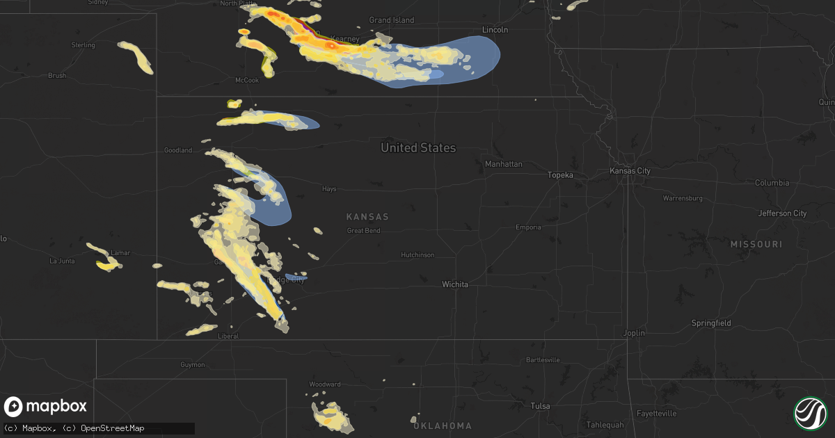
Hail Map in Kansas on July 6, 2024
Get this storm
July 6 map
$229
one time, instant access
Download today. No call, no setup
Keep the $229
Bought the map and want the full workflow? Apply the entire $229 to a subscription within 7 days. None of it is wasted.
Every map, not just this one
This buys you this map. Subscription and you get every map we run, in the markets you choose from a few cities to whole states to nationwide. Plus real-time alerts the moment a storm fires.
Contact data
Name, contact info, occupancy, even credit band for addresses in the footprint. You go from where it hit to who to call.
Become the source they trust
Unlimited branding weather history reports on demand. You already have the documented answer ready for the property owner, and you are the one who showed up with it.
Property data and RoofTrace estimates
Pull up any address you have got, its value and the exact code rules for that jurisdiction, straight from One Click Code. Then RoofTrace estimates the squares, pitch, and roof value, priced the way you price.
Storm reports in Kansas
Kansas
| Date | Description |
|---|---|
| 07/06/20246:55 PM CDT | A local report indicates 1.00 inch wind near Scott City |
| 07/06/20246:45 PM CDT | Mesonet station up856 0.8 e yocemento |
| 07/06/20245:09 PM CDT | Weather underground site kksutica3 reported a 64 mph gust. |
| 07/06/20245:09 PM CDT | A local report indicates 60 MPH wind near 15 SE Gove |
| 07/06/20245:04 PM CDT | Weather underground site kksutica3 reported a 60 mph wind gust. |
| 07/06/20245:00 PM CDT | Corrects previous tstm wnd dmg report from 1 nne the monument rocks. Reported via social media. Numerous cottonwood... Elm... And cedar trees down on the property. All |
| 07/06/20245:00 PM CDT | Reported via social media. Numerous trees down on the property. All were healthy. Storm started around 3:30 with peak winds occurring around 4 pm. Location also receive |
| 07/06/20244:36 PM CDT | A local report indicates 64 MPH wind near 10 S Quinter |
| 07/06/20244:35 PM CDT | Emergency manager reported a semi truck hauling a wind turbine blade was overturned due to straight line winds on hwy 83 near the smoky hill river bridge. Time is radar |
| 07/06/20244:33 PM CDT | Reported via ambient weather station my weather station. |
| 07/06/20244:20 PM CDT | Spotter estimated 70 mph gusts. Time is spotter and radar estimated. |
| 07/06/20244:01 PM CDT | Spotter estimated 60-70 mph winds ongoing. |
| 07/06/20243:50 PM CDT | A local report indicates 82 MPH wind near 6 NNW Gove |
| 07/06/20243:37 PM CDT | A local report indicates 65 MPH wind near 6 SSE Norton |
| 07/06/20243:26 PM CDT | Report from mping: trees uprooted or snapped; roof blown off. Unsure of the exact degree of damage. |
| 07/06/20243:26 PM CDT | A local report indicates 60 MPH wind near Campus |
| 07/06/20243:14 PM CDT | Reported via ambient weather station dog_house. |
| 07/06/20242:53 PM CDT | Delayed report. Two overturned semis reported near mile marker 64 on i-70 eastbound. Semis were empty. Most observations in the colby area measured around 50 mph when t |
| 07/06/20242:44 PM CDT | Reported via ambient weather station. |
| 07/06/20242:21 PM CDT | Spotter reported hail up to the size of quarters. Time estimated via radar. |
| 07/06/20242:10 PM CDT | Rawlins county dispatch has received reports of a tornado about 6 miles south of atwood. |
| 07/06/20242:07 PM CDT | Occurred at mm 75; then declined in size to nickel to dime. |
| 07/06/20241:53 PM CDT | Reported via social media. Occasional ping pong ball sized hail. Time estimated via radar. |
| 07/06/20241:40 PM CDT | Reported via social media. Dime to quarter sized hail fell for a duration of 10 minutes in herndon. Time radar estimated. |
| 07/06/20241:35 PM CDT | Public sent photos of 1-1.5 inch hail. Intersection of rds y/28 northeast of ludell. |
| 07/06/20242:05 AM CDT | Mesonet station gw3813 copeland. |
| 07/06/20241:03 AM CDT | A local report indicates 1.50 inch wind near 1 SSE Garden City |
| 07/06/20241:00 AM CDT | Report made via social media. |
| 07/06/20241:00 AM CDT | A local report indicates 1.25 inch wind near 1 SE Garden City |
| 07/05/202410:00 PM CDT | Mesonet station fw1214 la crosse. |
| 07/05/202410:00 PM CDT | Report made via social media. |
| 07/05/20249:45 PM CDT | Mesonet station fw1214 la crosse. |
| 07/05/20249:20 PM CDT | Asos station kgck garden city. |
| 07/05/20249:08 PM CDT | Asos station kgck garden city. |
| 07/05/20248:30 PM CDT | Mesonet station fw1214 la crosse. |
| 07/05/20248:24 PM CDT | Asos station kddc dodge city regional airport. |
| 07/05/20247:23 PM CDT | A local report indicates 1.50 inch wind near 1 SSW Scott City |
All States Impacted by Hail Map on July 6, 2024
Cities Impacted by Hail Map on July 6, 2024
- Sutherland, NE
- Hershey, NE
- North Platte, NE
- Nome, ND
- Enderlin, ND
- Maxwell, NE
- Brady, NE
- Gothenburg, NE
- Buchanan, ND
- Stapleton, NE
- Willow Island, NE
- Cozad, NE
- Lexington, NE
- Arnold, NE
- Elwood, NE
- Westby, MT
- Brockton, MT
- Overton, NE
- Eddyville, NE
- Bertrand, NE
- Smithfield, NE
- Lidgerwood, ND
- Wyndmere, ND
- Merna, NE
- Anselmo, NE
- Lebanon, SD
- Broken Bow, NE
- Callaway, NE
- Eustis, NE
- Franklin, GA
- Roanoke, AL
- Elm Creek, NE
- Seneca, SD
- Sylacauga, AL
- Clanton, AL
- Tolstoy, SD
- Cohasset, MN
- Loomis, NE
- Holdrege, NE
- Pelion, SC
- Herndon, KS
- Ludell, KS
- Faulkton, SD
- Kearney, NE
- Funk, NE
- Brewster, KS
- Atwood, KS
- Angora, MN
- Britt, MN
- Carrollton, GA
- Onaka, SD
- Oberlin, KS
- Levant, KS
- Axtell, NE
- Marshville, NC
- Wellfleet, NE
- Houston, TX
- Cook, MN
- Sumner, NE
- Hayes Center, NE
- Orient, SD
- Maywood, NE
- Palmetto, GA
- Colby, KS
- Oconto, NE
- Granada, MN
- Truman, MN
- Sisseton, SD
- Minden, NE
- Douglasville, GA
- New Effington, SD
- Newnan, GA
- Winnebago, MN
- Selden, KS
- Highmore, SD
- Pearland, TX
- Heartwell, NE
- Albemarle, NC
- Ree Heights, SD
- Isabella, MN
- Oakley, KS
- Curtis, NE
- Rockham, SD
- Hockley, TX
- Fresno, TX
- Jennings, KS
- Holabird, SD
- Waller, TX
- Miller, SD
- Katy, TX
- Rugby, ND
- Hitchcock, SD
- Redfield, SD
- Rexford, KS
- Moorefield, NE
- Stockville, NE
- Norcatur, KS
- New London, NC
- Hoxie, KS
- Clayton, KS
- Norton, KS
- Farnam, NE
- Dumont, MN
- Poplar, MT
- Kenesaw, NE
- Dresden, KS
- Atlanta, NE
- Indianola, NE
- Bartley, NE
- Cambridge, NE
- Saint Lawrence, SD
- Grinnell, KS
- Kettle River, MN
- Lenora, KS
- Cotton, MN
- Makinen, MN
- Monument, KS
- Mason, TX
- Fredericksburg, TX
- Hildreth, NE
- Juniata, NE
- Grainfield, KS
- Wood River, NE
- Wilcox, NE
- Wheaton, MN
- Bethune, SC
- Winona, KS
- Llano, TX
- Holstein, NE
- Almena, KS
- Logan, KS
- Prairie View, KS
- Brimson, MN
- Silverstreet, SC
- Kinards, SC
- Gove, KS
- Park, KS
- Gibbon, NE
- Frankfort, SD
- Lyons, GA
- Hastings, NE
- Doniphan, NE
- Forsyth, GA
- Doland, SD
- Clinton, SC
- Juliette, GA
- Quinter, KS
- Eveleth, MN
- Groton, SD
- Upland, NE
- Castell, TX
- Jackson, GA
- Humboldt, IA
- Campbell, NE
- Andover, SD
- Iroquois, SD
- Roseland, NE
- Ortonville, MN
- Willow Lake, SD
- Livermore, IA
- Hardy, IA
- Riverton, NE
- Bladen, NE
- Saco, MT
- Ayr, NE
- Glenvil, NE
- Trumbull, NE
- Inland, NE
- Blue Hill, NE
- Red Cloud, NE
- Harvard, NE
- Guide Rock, NE
- Lawrence, NE
- Fairfield, NE
- Healy, KS
- Collyer, KS
- Raymond, SD
- Thor, IA
- Ruthven, IA
- Graettinger, IA
- Emmetsburg, IA
- Pierpont, SD
- Clinton, MN
- Apex, NC
- Holly Springs, NC
- Crescent, IA
- Clark, SD
- Goldfield, IA
- Superior, NE
- Nelson, NE
- Deweese, NE
- Clay Center, NE
- Edgar, NE
- Saronville, NE
- Oak, NE
- Utica, KS
- Dighton, KS
- Eagle Grove, IA
- Stanley, ND
- Cylinder, IA
- Raleigh, NC
- Cary, NC
- Underwood, IA
- Chokio, MN
- Fort Peck, MT
- Bryant, SD
- Erwin, SD
- Lake Norden, SD
- Lake Preston, SD
- Biwabik, MN
- Scott City, KS
- Whittemore, IA
- West Bend, IA
- Aurora, MN
- Kershaw, SC
- San Saba, TX
- New Hill, NC
- Blue Earth, MN
- Algona, IA
- Ottosen, IA
- Bode, IA
- Ruskin, NE
- Davenport, NE
- Shickley, NE
- Sutton, NE
- Ong, NE
- Hebron, NE
- Carleton, NE
- Deshler, NE
- Grafton, NE
- Strang, NE
- Geneva, NE
- Bruning, NE
- Fairmont, NE
- Neola, IA
- Wesson, MS
- Gilbert, MN
- Arlington, SD
- Rutland, IA
- Minden, IA
- Goldthwaite, TX
- East Dublin, GA
- Letcher, SD
- Beeler, KS
- Arnold, KS
- Ransom, KS
- Ness City, KS
- Badger, SD
- Belvidere, NE
- Ohiowa, NE
- Exeter, NE
- Milligan, NE
- Tobias, NE
- Alexandria, NE
- Fairbury, NE
- Gilead, NE
- Daykin, NE
- Mullin, TX
- Marienthal, KS
- Shelby, IA
- Persia, IA
- Panhandle, TX
- Robert Lee, TX
- Delavan, MN
- Amarillo, TX
- Milan, MN
- Avoca, IA
- Hancock, IA
- Harlan, IA
- Pleasanton, NE
- Talpa, TX
- Lometa, TX
- Lawn, TX
- Ovalo, TX
- Santa Anna, TX
- Papillion, NE
- Omaha, NE
- McDade, TX
- Friend, NE
- Jansen, NE
- Plymouth, NE
- Swanton, NE
- Western, NE
- Wilber, NE
- Crete, NE
- Milford, NE
- Dorchester, NE
- De Witt, NE
- Bruce, SD
- Volga, SD
- Benson, MN
- Appleton, MN
- Echo, MN
- Wood Lake, MN
- Danvers, MN
- Tuscola, TX
- Abilene, TX
- Montevideo, MN
- Ravenna, NE
- Coleman, TX
- Dakota City, IA
- Claude, TX
- Clarion, IA
- Merriman, NE
- Valera, TX
- Oakland, IA
- Vincent, IA
- Spring Hope, NC
- Nashville, NC
- Woolstock, IA
- Martell, NE
- Hallam, NE
- Beatrice, NE
- Denton, NE
- Firth, NE
- Pickrell, NE
- Cortland, NE
- Clatonia, NE
- Pleasant Dale, NE
- Adams, NE
- Roca, NE
- Hickman, NE
- Sprague, NE
- Granite Falls, MN
- Silver City, IA
- Malvern, IA
- Gillett, TX
- Haxtun, CO
- Pacific Junction, IA
- Webster City, IA
- Bazine, KS
- Cimarron, KS
- Brownwood, TX
- Clare, IA
- Hyannis, NE
- Castalia, NC
- Glenwood, IA
- Elkton, SD
- Raymond, MN
- Clara City, MN
- Hastings, IA
- Henderson, IA
- Paoli, CO
- Holyoke, CO
- Alexander, KS
- Stockdale, TX
- Tulare, SD
- Maynard, MN
- Jetmore, KS
- Groom, TX
- Wray, CO
- Jasper, MN
- Trent, SD
- Harmony, NC
- Olin, NC
- Badger, IA
- Edgerton, MN
- Chandler, MN
- Prinsburg, MN
- Blairsburg, IA
- Emerson, IA
- Burdett, KS
- Rozel, KS
- Canyon, TX
- Lake Wilson, MN
- Slayton, MN
- Duncombe, IA
- Macedonia, IA
- Griswold, IA
- Red Oak, IA
- Carson, IA
- Union Grove, NC
- Hamptonville, NC
- Jewell, IA
- Kamrar, IA
- Garden City, KS
- Frazer, MT
- Springfield, MN
- Wayside, TX
- Pipestone, MN
- Hanston, KS
- Kinsley, KS
- Fulda, MN
- Ellsworth, IA
- Comfrey, MN
- Wright, KS
- Dodge City, KS
- Spearville, KS
- Radcliffe, IA
- Westbrook, MN
- Walnut Grove, MN
- Storden, MN
- Hubbard, IA
- Seneca, KS
- Roland, IA
- Revere, MN
- Happy, TX
- Tulia, TX
- Ingalls, KS
- Pierceville, KS
- McCallsburg, IA
- Zearing, IA
- Saint Anthony, IA
- New Providence, IA
- Clemons, IA
- Ashby, NE
- Whitman, NE
- Montezuma, KS
- Copeland, KS
- Union, IA
- Marshalltown, IA
- Albion, IA
- Ensign, KS
- Meade, KS
- Fowler, KS
- Carter Lake, IA
- Plains, KS
- Tabor, IA
- Council Bluffs, IA
- Springfield, NE
- Leoti, KS
- Deerfield, KS
- Holcomb, KS
- Leesville, SC
- Salley, SC
- Englewood, KS
- Minneola, KS
- Hasty, CO
- Oshkosh, NE
- Lamar, CO
- Bricelyn, MN
- Las Animas, CO
- Syracuse, KS
- Holly, CO
- McClave, CO
- Sublette, KS
- Aline, OK
- Sharon, OK
- Rolla, KS
- Arnett, OK
- Vici, OK
- Manter, KS
- Hugoton, KS
- Leedey, OK
- Johnson, KS
- Taloga, OK
- Enid, OK
- Camargo, OK
- Seiling, OK
- Kingfisher, OK
- Hennessey, OK
- Ulysses, KS
- Dover, OK
- Fargo, OK
- Putnam, OK
- Satanta, KS
- Custer City, OK
- Woodward, OK
- Moscow, KS
- Mutual, OK
- Liberal, KS
- Parks, NE


