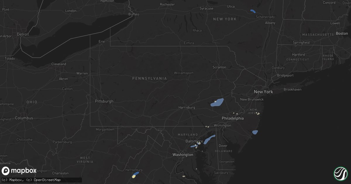
Hail Map in Pennsylvania on July 1, 2025
Get this storm
July 1 map
$229
one time, instant access
Download today. No call, no setup
Keep the $229
Bought the map and want the full workflow? Apply the entire $229 to a subscription within 7 days. None of it is wasted.
Every map, not just this one
This buys you this map. Subscription and you get every map we run, in the markets you choose from a few cities to whole states to nationwide. Plus real-time alerts the moment a storm fires.
Contact data
Name, contact info, occupancy, even credit band for addresses in the footprint. You go from where it hit to who to call.
Become the source they trust
Unlimited branding weather history reports on demand. You already have the documented answer ready for the property owner, and you are the one who showed up with it.
Property data and RoofTrace estimates
Pull up any address you have got, its value and the exact code rules for that jurisdiction, straight from One Click Code. Then RoofTrace estimates the squares, pitch, and roof value, priced the way you price.
Storm reports in Pennsylvania
Pennsylvania
| Date | Description |
|---|---|
| 07/01/20254:53 PM CDT | Multiple trees down. Time estimated from radar. |
| 07/01/20254:14 PM CDT | Multiple trees snapped and uprooted. Time estimated from radar. |
| 07/01/20254:00 PM CDT | Multiple reports of trees and wires down. Time estimated from radar. |
| 07/01/20253:58 PM CDT | Tree on a car. Time estimated from radar. |
| 07/01/20253:58 PM CDT | Multiple reports of trees and wires down. Time estimated from radar. |
| 07/01/20253:56 PM CDT | Social media post showed a tree down blocking a roadway in boyertown. Time estimated from radar. |
| 07/01/20253:48 PM CDT | Multiple trees uprooted and snapped on weavertown road. Tornado possible. Time estimated from radar. |
| 07/01/20253:48 PM CDT | Tree into a house on conrad road with multiple people trapped. |
| 07/01/20253:46 PM CDT | Some large trees blown over on weavertown road in douglassville. Time estimated from radar. |
| 07/01/20253:46 PM CDT | Social media post shows several trees down in locust grove in amity. Time estimated from radar. |
| 07/01/20253:43 PM CDT | Thunderstorm damage reported near the intersection of sunset drive and pleasant valley road. |
| 07/01/20253:40 PM CDT | Some trees down on lake road in oley... Some blocking the roadway. Time estimated from radar. |
| 07/01/20253:40 PM CDT | Tree uprooted. Time estimated from radar. |
| 07/01/20253:38 PM CDT | Picture shows large tree down across main street in gibraltar. Time estimated from radar. |
| 07/01/20253:33 PM CDT | Multiple trees down in bethel township. |
| 07/01/20253:33 PM CDT | Multiple trees down in bethel to |
| 07/01/20253:31 PM CDT | 63 mph thunderstorm wind gust... And 41 mph sustained wind. |
| 07/01/20253:28 PM CDT | 58 mph thunderstorm wind gust... And 45 mph sustained wind. |
| 07/01/20253:27 PM CDT | Tree down with no wires on fox ridge lane. |
| 07/01/20253:25 PM CDT | Picture shows trees down on reedy road in the whitfield area of sinking springs. Time estimated from radar. |
| 07/01/20253:06 PM CDT | Tree down across dark hollow road in hellam township. |
| 07/01/20253:03 PM CDT | Tree down on wires. |
| 07/01/20253:02 PM CDT | Tree down on wires on ted wallace road in chanceford township. |
| 07/01/20252:50 PM CDT | Multiple trees down in jackson township. |
| 07/01/20252:35 PM CDT | Tree down into wires. |
| 07/01/20252:35 PM CDT | Trees and wires down on palmyra bellegrove road near the intersection of albert drive. |
| 07/01/20252:05 PM CDT | Trees down on bustleton ave and winchester ave blocking much of the roadway. Time estimated from radar. |
| 07/01/20251:55 PM CDT | Trees down all along west christine road from the county line to hopewell road. Time estimated from radar. |
| 07/01/20251:40 PM CDT | Trees and wires down on hopewell road. One tree fell on a vehicle. Time estimated from radar. |
| 07/01/20251:35 PM CDT | Trees and wires down at the intersection of fremont road and lees bridge road. Time estimated from radar. |
| 07/01/20251:35 PM CDT | Trees on wires near the intersection of west christine road & glenroy road. Time estimated from radar. |
All States Impacted by Hail Map on July 1, 2025
Cities Impacted by Hail Map on July 1, 2025
- Colora, MD
- Rising Sun, MD
- Jenkintown, PA
- Glenside, PA
- Abington, PA
- Fonda, NY
- Johnstown, NY
- Fort Plain, NY
- Saint Johnsville, NY
- Salem, VA
- Fultonville, NY
- Newton, MS
- Laurel, MS
- Philadelphia, PA
- Bensalem, PA
- Sparrows Point, MD
- Etowah, TN
- Hanover, MD
- Severn, MD
- Fort George G Meade, MD
- Millersville, MD
- Glen Burnie, MD
- Peach Bottom, PA
- Conowingo, MD
- Pasadena, MD
- Curtis Bay, MD
- Fort Howard, MD
- Port Republic, VA
- Grottoes, VA
- Mount Crawford, VA
- Weyers Cave, VA
- Mount Sidney, VA
- Fort Defiance, VA
- Crimora, VA
- Dundalk, MD
- Severna Park, MD
- Pascagoula, MS
- Moss Point, MS
- Oak Grove, LA
- McGaheysville, VA
- Harrisonburg, VA
- Penn Laird, VA
- Worton, MD
- Chestertown, MD
- Reading, PA
- Temple, PA
- Birdsboro, PA
- Essex, MD
- Benton, MS
- Vaughan, MS
- Yazoo City, MS
- Camden, MS
- Greensboro, AL
- Moundville, AL
- Oley, PA
- Douglassville, PA
- Boyertown, PA
- Fleetwood, PA
- Mertztown, PA
- Alburtis, PA
- Still Pond, MD
- Kennedyville, MD
- Betterton, MD
- Bechtelsville, PA
- Gilbertsville, PA
- Topton, PA
- Barto, PA
- Macungie, PA
- Bally, PA
- Marion, AL
- Brent, AL
- Bentonia, MS
- Rolling Fork, MS
- Centreville, AL
- Canton, MS
- Blandon, PA
- Demopolis, AL
- Jackson, NJ
- Ocean Springs, MS
- Earleville, MD
- Moselle, MS
- Hattiesburg, MS
- Seminary, MS
- Petal, MS
- Hereford, PA
- Zionsville, PA
- East Greenville, PA
- Palm, PA
- Emmaus, PA
- Pickens, MS
- Stevensville, MD
- Lakewood, NJ
- Warwick, MD
- Chesapeake City, MD
- Brandon, MS
- Brick, NJ
- Rapid City, SD
- Madison, MS
- Flora, MS
- Biloxi, MS
- Bolton, MS
- Jackson, MS
- Lena, MS
- Saucier, MS
- Gulfport, MS
- Selma, AL
- Weogufka, AL
- Goodwater, AL
- Pine Apple, AL
- Diberville, MS
- Locust Grove, GA
- Kellyton, AL
- Elkton, VA
- Keystone, SD
- Montgomery, AL
- Sylacauga, AL
- Rockford, AL
- Moorcroft, WY
- Capitol, MT
- Jenkinsburg, GA
- Hermosa, SD
- Glen Allen, VA
- Ashland, VA
- Mechanicsville, VA
- Hanover, VA
- Alzada, MT
- Rozet, WY
- Devils Tower, WY
- Grantville, GA
- Ruther Glen, VA
- Aylett, VA
- Doswell, VA
- Manquin, VA
- Kadoka, SD
- Prattville, AL
- Interior, SD
- Fairburn, SD
- Franklin, GA
- Junction City, CA
- Buffalo Gap, SD
- Oral, SD
- Colonial Beach, VA
- Repton, AL
- Monroeville, AL
- Tuckerton, NJ
- Beach Haven, NJ
- Manhattan, MT
- Belgrade, MT
- Bozeman, MT
- Belvidere, SD
- Evergreen, AL
- Lodgepole, NE
- Pine Ridge, SD
- Prescott, AZ
- Issue, MD
- Weaverville, CA
- Buchanan, VA
- Hot Springs, SD
- Murdo, SD
- White River, SD
- Kyle, SD
- Douglas City, CA
- Chino Valley, AZ
- Gaffney, SC
- Livingston, MT
- Gallatin Gateway, MT
- Port Republic, MD
- Saint Leonard, MD
- Lexington Park, MD
- Wanblee, SD
- Okaton, SD
- Oelrichs, SD
- Smithwick, SD
- Marion, LA
- Amelia Court House, VA
- Jetersville, VA
- Porcupine, SD
- Fayette, MS
- Norris, SD
- Lorman, MS
- Alliance, NE
- Buffalo, SD
- Port Gibson, MS
- Chadron, NE
- Batesland, SD
- Allen, SD
- Martin, SD
- Wounded Knee, SD
- Ellsworth, NE
- Belle Fourche, SD
- Rushville, NE
- Hay Springs, NE
- Gordon, NE
- Merriman, NE
- Parmelee, SD
- Roxie, MS
- Natchez, MS
- Winner, SD
- Witten, SD
- Colome, SD
- Ideal, SD
- Klamath Falls, OR
- Oshkosh, NE
- Long Valley, SD
- Tuthill, SD
- Mission, SD
- Wood, SD
- Midland, OR
- Saint Francis, SD
- Rosebud, SD
- Forks Of Salmon, CA
- Cody, NE
- Whitman, NE
- Woodville, MS
- Crosby, MS
- Gazelle, CA
- Yreka, CA
- Burwell, NE
- Redding, CA
- Lewiston, CA
- Valentine, NE
- Mullen, NE
- Naper, NE
- Bassett, NE
- Amelia, NE
- Stuart, NE
- Eureka, SD
- Hosmer, SD
- Bowdle, SD
- Leola, SD
- Ericson, NE
- Greeley, NE
- Spalding, NE
- Grand Island, NE
- Saint Libory, NE
- Frankfort, SD
- Chapman, NE
- Phillips, NE
- Inman, NE
- Page, NE
- Oneill, NE
- Emmet, NE
- Atkinson, NE
- Ewing, NE


