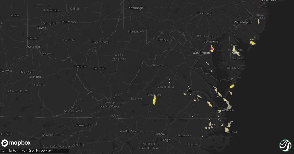
Hail Map in Virginia on July 1, 2020
Get this storm
July 1 map
$229
one time, instant access
Download today. No call, no setup
Keep the $229
Bought the map and want the full workflow? Apply the entire $229 to a subscription within 7 days. None of it is wasted.
Every map, not just this one
This buys you this map. Subscription and you get every map we run, in the markets you choose from a few cities to whole states to nationwide. Plus real-time alerts the moment a storm fires.
Contact data
Name, contact info, occupancy, even credit band for addresses in the footprint. You go from where it hit to who to call.
Become the source they trust
Unlimited branding weather history reports on demand. You already have the documented answer ready for the property owner, and you are the one who showed up with it.
Property data and RoofTrace estimates
Pull up any address you have got, its value and the exact code rules for that jurisdiction, straight from One Click Code. Then RoofTrace estimates the squares, pitch, and roof value, priced the way you price.
Storm reports in Virginia
Virginia
| Date | Description |
|---|---|
| 07/01/20204:35 PM CDT | Trees down and dime size hail. |
| 07/01/20203:49 PM CDT | Buckingham county sheriffs office reported that a large tree limb was down in the road at the intersection of south constitution and snowden road... Just barely inside |
| 07/01/20203:45 PM CDT | Trees and power lines down near garysville. Time estimated by radar. |
| 07/01/20203:35 PM CDT | Large limb in the road at the intersection of s constitution rte and snowden road. |
| 07/01/20203:20 PM CDT | Tree down in the vicinity of halls run road. Time estimated by radar. Report via virginia 511. |
| 07/01/20203:20 PM CDT | Tree down in the road on beach rd. Time estimated by radar. |
| 07/01/20203:12 PM CDT | Numerous trees down near the intersection of carters mountain road and scottsville road |
| 07/01/20202:42 PM CDT | Numerous trees down near the 3900 block of free union road |
| 07/01/20201:20 PM CDT | Trees down and high winds. |
| 07/01/20201:00 PM CDT | A local report indicates 1.00 inch wind near 1 NNE ACCOMAC |
| 07/01/20205:10 AM CDT | At 1009 PM EDT, a severe thunderstorm was located near Leda, or near Nathalie, moving south at 25 mph. HAZARD...60 mph wind gusts. SOURCE...Radar indicated. IMPACT...Expect damage to roofs, siding, and trees. Locations impacted include... South Boston... Yanceyville... Bethel... Halifax... Jericho... Prospect Hill... and Turbeville. |
| 07/01/20203:49 AM CDT | At 848 PM EDT, a severe thunderstorm was located near Gladys, or 7 miles south of Rustburg, moving south at 20 mph. HAZARD...Ping pong ball size hail and 60 mph wind gusts. SOURCE...Radar indicated. IMPACT...People and animals outdoors will be injured. Expect hail damage to roofs, siding, windows, and vehicles. Expect wind damage to roofs, siding, and trees. Locations impacted include... Altavista... Hurt... Mt Airy... Hodges... Cody... Leda... and Gladys. |
| 07/01/20203:13 AM CDT | At 812 PM EDT, a severe thunderstorm was located over Bocock, or near Rustburg, moving south at 20 mph. HAZARD...60 mph wind gusts and quarter size hail. SOURCE...Radar indicated. IMPACT...Hail damage to vehicles is expected. Expect wind damage to roofs, siding, and trees. Locations impacted include... Lynchburg... Concord... Rustburg... Madison Heights... Mike... Gladys... and Bocock.This includes The following Locations Liberty University andLynchburg Airport. |
| 07/01/202012:29 AM CDT | At 528 PM EDT, a severe thunderstorm was located over Great Bridge, moving southeast at 15 mph. HAZARD...60 mph wind gusts and quarter size hail. SOURCE...Radar indicated. IMPACT...Minor damage to vehicles is possible. Expect wind damage to trees and powerlines. This severe thunderstorm will be near, Great Bridge around 535 PM EDT. Fentress around 550 PM EDT. Princess Anne around 600 PM EDT.Other locations impacted by this severe thunderstorm includeGreenbrier, Gallups Corner, Mount Pleasant, Hickory and Pungo. |
| 06/30/202011:53 PM CDT | At 453 PM EDT, a severe thunderstorm was located near Rescue, or near Smithfield, moving southeast at 25 mph. HAZARD...Ping pong ball size hail and 60 mph wind gusts. SOURCE...Radar indicated. IMPACT...People and animals outdoors will be injured. Expect hail damage to roofs, siding, windows, and vehicles. Expect wind damage to trees and powerlines. This severe thunderstorm will be near, Christopher Newport University, Rescue and Beaconsdale around 505 PM EDT. Northampton around 515 PM EDT. Hampton University around 525 PM EDT. Fort Monroe around 530 PM EDT.Other locations impacted by this severe thunderstorm includeCarrollton, Phoebus, Langley View, Oyster Point, Mogarts Beach,Hilton Village, Menchville, Lawson and Raleigh Terrace. |
| 06/30/202011:24 PM CDT | At 424 PM EDT, a severe thunderstorm was located 7 miles southwest of Lake Monticello, or 9 miles west of Palmyra, moving south at 30 mph. HAZARD...60 mph wind gusts and quarter size hail. SOURCE...Radar indicated. IMPACT...Minor damage to vehicles is possible. Expect wind damage to trees and powerlines. This severe thunderstorm will remain over mainly rural areas of western Fluvanna County, including the following locations... Dixie, Nahor, Cohasset, Shores, Hardware, Carysbrook, Central Plains, Bremo Bluff, Antioch and Cunningham. |
| 06/30/202011:24 PM CDT | At 422 PM EDT, severe thunderstorms extended from near Lake Monticello to 7 miles northeast of Schuyler, moving south at 25 mph. HAZARD...60 mph wind gusts and quarter size hail. SOURCE...Radar indicated. IMPACT...Hail damage to vehicles is expected. Expect wind damage to roofs, siding, and trees. Locations impacted include... Dillwyn... New Canton... Gold Hill... and Centenary. |
| 06/30/202011:18 PM CDT | At 418 PM EDT, severe thunderstorms were located along a line extending from near Richmond to near Bellwood to near Chester, moving southeast at 20 mph. HAZARD...60 mph wind gusts and quarter size hail. SOURCE...Radar indicated. IMPACT...Minor damage to vehicles is possible. Expect wind damage to trees and powerlines. Severe thunderstorms will be near, Chester around 425 PM EDT. Colonial Heights, Bellwood and Ettrick around 435 PM EDT. Fort Lee around 445 PM EDT. Petersburg and Hopewell around 450 PM EDT. Prince George, Jordans Point and Garysville around 500 PM EDT.Other locations impacted by these severe thunderstorms includeWayside, Richmond Heights, Birchett Estate, Elko, Jordan PointCountry Club, Montrose, Petersburg National Battlefield, Glendale,Richmond International and Meadowville. |
| 06/30/202011:10 PM CDT | At 409 PM EDT, a severe thunderstorm was located 8 miles northeast of Schuyler, or 12 miles southwest of Charlottesville, moving southeast at 15 mph. HAZARD...60 mph wind gusts and quarter size hail. SOURCE...Radar indicated. IMPACT...Damaging winds will cause some trees and large branches to fall. This could injure those outdoors, as well as damage homes and vehicles. Roadways may become blocked by downed trees. Localized power outages are possible. Unsecured light objects may become projectiles. Locations impacted include... Scottsville, Esmont, Keene, Glendower and Alberene. |
| 06/30/202011:02 PM CDT | At 402 PM EDT, a severe thunderstorm was located near Charlottesville, moving southeast at 30 mph. HAZARD...60 mph wind gusts and quarter size hail. SOURCE...Radar indicated. IMPACT...Damaging winds will cause some trees and large branches to fall. This could injure those outdoors, as well as damage homes and vehicles. Roadways may become blocked by downed trees. Localized power outages are possible. Unsecured light objects may become projectiles. Locations impacted include... Charlottesville, Woodridge, Monticello, Overton and Shadwell. |
| 06/30/202010:40 PM CDT | At 340 PM EDT, a severe thunderstorm was located near Rustic, or near Claremont, moving east at 20 mph. HAZARD...60 mph wind gusts and quarter size hail. SOURCE...Radar indicated. IMPACT...Minor damage to vehicles is possible. Expect wind damage to trees and powerlines. This severe thunderstorm will be near, Rustic around 350 PM EDT. Claremont around 355 PM EDT. Williamsburg around 425 PM EDT. College Of William And Mary around 430 PM EDT.Other locations impacted by this severe thunderstorm include MountAiry, Brandon, Governors Land, Centerville and Spring Grove. |
| 06/30/202010:17 PM CDT | At 317 PM EDT, a severe thunderstorm was located over Adkins Store, or over Charles City, moving east at 10 mph. HAZARD...60 mph wind gusts and quarter size hail. SOURCE...Radar indicated. IMPACT...Minor damage to vehicles is possible. Expect wind damage to trees and powerlines. This severe thunderstorm will be near, Charles City around 335 PM EDT. Ruthville around 345 PM EDT.Other locations impacted by this severe thunderstorm includeSandybottom, New Hope and Roaches Corner. |
| 06/30/20209:57 PM CDT | At 257 PM EDT, a severe thunderstorm was located 8 miles east of Bavon, or 10 miles northwest of Cape Charles, moving southeast at 20 mph. HAZARD...60 mph wind gusts and penny size hail. SOURCE...Radar indicated. IMPACT...Expect damage to trees and powerlines. This severe thunderstorm will be near, Cape Charles and Cheriton around 330 PM EDT. Bay View around 335 PM EDT.Other locations impacted by this severe thunderstorm includeSimpkins, Capeville, Townsend, Kiptopeke State Park, Oyster,Eastville, Kiptopeke, Cheapside, Plantation and Dalbys. |
| 06/30/20209:22 PM CDT | Updates previous tstm wnd dmg report from 3 sse vernon hill. Several trees down in the vicinity of oak level road and lewis ferrell road. |
| 06/30/20209:22 PM CDT | One tree downed at the intersection of lewis farrell road and oak level road. Time estimated from radar. |
| 06/30/20209:07 PM CDT | At 207 PM EDT, a severe thunderstorm was located near Parksley, or 19 miles northeast of Exmore, moving northeast at 15 mph. HAZARD...60 mph wind gusts and quarter size hail. SOURCE...Radar indicated. IMPACT...Minor damage to vehicles is possible. Expect wind damage to trees and powerlines. This severe thunderstorm will remain over mainly rural areas of central Accomack County, including the following locations... Nelsonia, Assawoman, Modest Town, Mappsville and Wallops Island. |
| 06/30/20209:00 PM CDT | At 159 PM EDT, a severe thunderstorm was located over Deltaville, moving southeast at 10 mph. HAZARD...60 mph wind gusts and penny size hail. SOURCE...Radar indicated. IMPACT...Expect damage to trees and powerlines. This severe thunderstorm will be near, Mathews and Gwynn around 225 PM EDT.Other locations impacted by this severe thunderstorm include Dutton,Diggs, Ruff, Moon, Laban, Cobbs Creek, Hudgins, Wilton, Amburg andStampers. |
| 06/30/20208:41 PM CDT | One tree down across tobacco road. |
| 06/30/20208:37 PM CDT | At 137 PM EDT, a severe thunderstorm was located over Onley, or 12 miles northeast of Exmore, and is nearly stationary. HAZARD...60 mph wind gusts and quarter size hail. SOURCE...Radar indicated. IMPACT...Minor damage to vehicles is possible. Expect wind damage to trees and powerlines. This severe thunderstorm will remain over mainly rural areas of central Accomack County, including the following locations... Locustville, Accomac and Tasley. |
| 06/30/20208:35 PM CDT | One tree down on stage coach road. |
| 06/30/20208:00 PM CDT | Multiple trees down in the vicinity of sunnymeade road off english tavern road. |
| 06/30/20207:26 PM CDT | Radar estimated time. Tree reported down at 880 surburban rd. Rustburg... Va. |
| 06/30/20207:26 PM CDT | Radar estimated time. Trees down at 385 poor house rd. Rustburg... Va. |
| 06/30/20207:26 PM CDT | Tree down on railroad tracks near poor house rd. |
| 06/30/20207:24 PM CDT | Radar estimated time. Trees reported down at 3411 sunnymeade rd. Rustburg... Va. |
| 06/30/20207:19 PM CDT | Trees down on railroad tracks near pleasant hill road. |
| 06/30/20207:17 PM CDT | Radar estimated time. Tree reported down around 8:42pm along the 4000 block of morningside drive. |
| 06/30/20207:17 PM CDT | Wset meterologists relayed a report of significant storm damage to a barn from one of their viewers on nest lane just off old rustburg road on the southeast side of lyn |
| 06/30/20207:13 PM CDT | Radar estimated time. Trees down in the vicinity of clydesdale drive and camp hydaway rd. |
| 06/30/20207:13 PM CDT | Radar estimated time. Trees down at the intersection of oxford furnace rd. And village hwy. |
All States Impacted by Hail Map on July 1, 2020
Cities Impacted by Hail Map on July 1, 2020
- Lumberton, MS
- Orange City, FL
- Deltona, FL
- Crowell, TX
- Quanah, TX
- Cedarcreek, MO
- Ballinger, TX
- Paint Rock, TX
- Rowena, TX
- Annapolis, MD
- Edgewater, MD
- Severna Park, MD
- Arnold, MD
- Woodbine, NJ
- Ocean View, NJ
- Estell Manor, NJ
- Lucedale, MS
- Moss Point, MS
- Vancourt, TX
- Greenwood, MS
- Talpa, TX
- Deerfield, KS
- Satanta, KS
- Northport, AL
- Manchester Township, NJ
- Lakehurst, NJ
- Cobbs Creek, VA
- Hallieford, VA
- Hudgins, VA
- Bardwell, KY
- Sidon, MS
- Cruger, MS
- Macon, MS
- Carthage, MS
- Bush, LA
- Ulysses, KS
- Ozona, TX
- Cape Charles, VA
- Hermitage, MO
- Viola, AR
- Salem, AR
- Wingo, KY
- Norway, KS
- Courtland, KS
- Westbrook, TX
- Loraine, TX
- Powhatan, VA
- Eufaula, AL
- Chaseley, ND
- Harvey, ND
- Andalusia, AL
- Altavista, VA
- Gladys, VA
- Lynchburg, VA
- Rustburg, VA
- San Angelo, TX
- Williford, AR
- Charles City, VA
- Dyersburg, TN
- De Kalb, MS
- Collinsville, MS
- Daleville, MS
- Porterville, MS
- Bailey, MS
- Eden, TX
- Picayune, MS
- Perkinston, MS
- Deepwater, MO
- Morton, MS
- Lakin, KS
- Manila, AR
- Lauderdale, MS
- Cuba, AL
- Ashford, AL
- Cottonwood, AL
- Forgan, OK
- Sonora, TX
- Leoti, KS
- Cando, ND
- Egeland, ND
- Louisville, MS
- Noxapater, MS
- Dryden, TX
- Winters, TX
- Greenwood, DE
- Milford, DE
- Houston, DE
- Colorado City, TX
- Eupora, MS
- Mathiston, MS
- Hopkins, SC
- Columbia, SC
- Eastover, SC
- Lena, MS
- Eldorado, TX
- Moscow, KS
- Bainbridge, GA
- Colquitt, GA
- Scottsville, VA
- Caulfield, MO
- Salem, CT
- Old Lyme, CT
- East Haddam, CT
- Christoval, TX
- Virginia Beach, VA
- Evington, VA
- Hardy, AR
- Lincoln, DE
- Bowdon, ND
- Disputanta, VA
- Camden, AL
- Sedalia, KY
- Dora, MO
- Sweetwater, TX
- Chesapeake, VA
- Haines City, FL
- Winter Haven, FL
- Dundee, FL
- Kismet, KS
- Emporia, KS
- Roach, MO
- Rotan, TX
- McLain, MS
- Atlanta, MO
- Mechanicsville, MD
- Charlotte Hall, MD
- Hughesville, MD
- Onley, VA
- Accomac, VA
- Council Grove, KS
- White City, KS
- Letohatchee, AL
- Hardyville, VA
- Deltaville, VA
- Wake, VA
- Colchester, CT
- Marion, KS
- Lawn, TX
- Ovalo, TX
- Windsor, MO
- Wheatland, MO
- Edwards, MO
- Brewton, AL
- Diberville, MS
- Biloxi, MS
- Gulfport, MS
- New Egypt, NJ
- Dover, DE
- Harrington, DE
- Camden Wyoming, DE
- Felton, DE
- Viola, DE
- Magnolia, DE
- Jackson, AL
- Sainte Genevieve, MO
- Gates, NC
- Corapeake, NC
- Calico Rock, AR
- Prairie, MS
- Gatesville, NC
- Tyner, NC
- Sunbury, NC
- Belvidere, NC
- Hobbsville, NC
- Hertford, NC
- Whiteville, TN
- Somerville, TN
- Roscoe, TX
- Carlsbad, TX
- Cathay, ND
- Leonard, MO
- Pulaski, MS
- Camden, NC
- Aspermont, TX
- Samson, AL
- Oberon, ND
- Sea Isle City, NJ
- Strathmere, NJ
- Marmora, NJ
- Ocean City, NJ
- Cape May Court House, NJ
- Mountain View, AR
- Windsor, NC
- Hattiesburg, MS
- Jarvisburg, NC
- Grandy, NC
- Powells Point, NC
- Norton, TX
- Pasadena, MD
- Davidsonville, MD
- Crownsville, MD
- Riva, MD
- Melbourne, AR
- Vincentown, NJ
- Ava, MO
- Chatom, AL
- Onancock, VA
- Parksley, VA
- Melfa, VA
- Maben, MS
- Spring Grove, VA
- Walnut Grove, MS
- Brooksville, MS
- Coffeeville, MS
- Bells, TN
- Mize, MS
- Emelle, AL
- Kendall, KS
- Drew, MS
- Starkville, MS
- Gordon, AL
- Jakin, GA
- Flemington, MO
- Lebanon, MO
- Phillipsburg, MO
- Mobile, AL
- Brixey, MO
- Wasola, MO
- Benton, MS
- Bentonia, MS
- Ellendale, DE
- Eldorado, OK
- Meridian, MS
- Senatobia, MS
- Greenville, AL
- Preston, CT
- Ledyard, CT
- West Plains, MO
- Moody, MO
- Gamaliel, AR
- Pine Apple, AL
- Valdosta, GA
- Leonardtown, MD
- Elk City, OK
- Dexter, MO
- Novice, TX
- Diggs, VA
- Moon, VA
- Gwynn, VA
- Newton, AL
- New Rockford, ND
- Mountain Home, AR
- Gassville, AR
- Rueter, MO
- Bradleyville, MO
- Kissee Mills, MO
- Baker, FL
- Holt, FL
- Egg Harbor Township, NJ
- Toone, TN
- Medon, TN
- Silas, AL
- Bowie, MD
- Upper Marlboro, MD
- Prince George, VA
- Fort Lee, VA
- Petersburg, VA
- Sublette, KS
- Sheyenne, ND
- Poughkeepsie, AR
- Bay Springs, MS
- Edenton, NC
- Saraland, AL
- Daphne, AL
- Warsaw, MO
- Greenbush, VA
- Forest, MS
- Stockton, AL
- Vancleave, MS
- Sturkie, AR
- Theodore, AL
- Brandon, MS
- Canton, MS
- Corolla, NC
- Pearl, IL
- Pottersville, MO
- Coila, MS
- Bradford, AR
- Leeton, MO
- Warrensburg, MO
- Shiloh, NC
- Harbinger, NC
- Boston, GA
- Thomasville, GA
- Pavo, GA
- Yaphank, NY
- Ridge, NY
- Manorville, NY
- Shirley, NY
- Citronelle, AL
- Leakesville, MS
- Maddock, ND
- Blakely, GA
- McCool, MS
- Millry, AL
- Harrellsville, NC
- Cofield, NC
- Colerain, NC
- Aberdeen, MS
- Birdsnest, VA
- Painter, VA
- Deer Park, AL
- Fruitdale, AL
- Vinegar Bend, AL
- Campbell, MO
- Qulin, MO
- Poplar Bluff, MO
- Livingston, AL
- Bolivar, MO
- Ravenden, AR
- Woodbine, KS
- Philadelphia, MS
- Cross Timbers, MO
- Chesterfield, VA
- Richmond, VA
- Dudley, MO
- Bloomfield, MO
- Arlington, KY
- Smithville, AR
- Cunningham, KY
- Topping, VA
- White Stone, VA
- Opp, AL
- Milton, FL
- Shawboro, NC
- Kosciusko, MS
- Sallis, MS
- Glen Allen, VA
- Grenada, MS
- Scobey, MS
- Tillatoba, MS
- Pelahatchie, MS
- New Madrid, MO
- Clinton, MO
- Scandia, KS
- Jamestown, KS
- Cuthbert, GA
- Red Level, AL
- Surry, VA
- Smithfield, VA
- Carrollton, VA
- Blackwell, MO
- Martin, TN
- Dukedom, TN
- Cottage Grove, TN
- Puryear, TN
- Java, VA
- Chatham, VA
- Water Valley, MS
- Emporia, VA
- Forest Home, AL
- Georgiana, AL
- Beaumont, MS
- Geneva, FL
- Louin, MS
- Raleigh, MS
- Callao, MO
- Bevier, MO
- Palmyra, MO
- Jackson, NJ
- Preston, MO
- Kinston, AL
- Bethel, MO
- Buffalo, MO
- Adel, GA
- Hahira, GA
- Long Beach, MS
- Woodland, MS
- Houston, MS
- Coffeeville, AL
- Thomasville, AL
- Mertzon, TX
- Moseley, VA
- Mansfield, MO
- Bernie, MO
- Parma, MO
- Bexar, AR
- Elizabeth, AR
- Elrod, AL
- Gordo, AL
- Heber Springs, AR
- Drasco, AR
- Higden, AR
- Abbeville, AL
- Abita Springs, LA
- Ewing, MO
- Vardaman, MS
- Calhoun City, MS
- Clinton, KY
- Mayfield, KY
- Bolivar, TN
- Grove Hill, AL
- Norfolk, VA
- Matthews, MO
- Itta Bena, MS
- Winona, MS
- Midlothian, VA
- Sturgis, MS
- Murray, KY
- Enid, MS
- Lothian, MD
- Jonesboro, AR
- Osceola, AR
- Herington, KS
- Elkland, MO
- Conway, MO
- Yellville, AR
- Columbia, AL
- Puxico, MO
- Paragould, AR
- Uncasville, CT
- Oakdale, CT
- Moyock, NC
- Milton, DE
- Dunnegan, MO
- Fair Play, MO
- Solomon, KS
- Oxford, MS
- Charleston, MS
- Covington, TN
- Sterling City, TX
- Theodosia, MO
- Protem, MO
- Killingworth, CT
- Higganum, CT
- Powhatan, AR
- Crescent City, FL
- Charlottesville, VA
- Tibbie, AL
- Pass Christian, MS
- Hazel, KY
- Evergreen, AL
- Niangua, MO
- Tunas, MO
- Macks Creek, MO
- Loxahatchee, FL
- Grand Bay, AL
- New Orleans, LA
- Pickens, MS
- Lexington, MS
- Concordia, KS
- East Prairie, MO
- Dundalk, MD
- Durant, MS
- Tribune, KS
- Onemo, VA
- Roby, TX
- Marion Station, MD
- Paris, TN
- Neely, MS
- Leroy, AL
- Chapman, KS
- Anaconda, MT
- Port Haywood, VA
- Susan, VA
- Tecumseh, MO
- Jewell, KS
- Gales Ferry, CT
- Bertrand, MO
- Oakland, MS
- Chunchula, AL
- Waldorf, MD
- Kiln, MS
- Camden, TN
- Oldfield, MO
- Fessenden, ND
- Fulton, KY
- Hickory Valley, TN
- Donalsonville, GA
- Brinson, GA
- Iron City, GA
- Hopewell, VA
- Palmersville, TN
- Chester, CT
- Woodside, DE
- Chadwick, MO
- Henrico, VA
- Louisburg, MO
- Coffee Springs, AL
- Warwick, ND
- McEwen, TN
- Lakeland, GA
- Ray City, GA
- Essex, MO
- Stonewall, MS
- Weems, VA
- Irvington, VA
- Lancaster, VA
- Wallops Island, VA
- Plains, KS
- Winchester, IL
- Pontotoc, MS
- Bono, AR
- Cedarbluff, MS
- Vaiden, MS
- Millersville, MD
- Glen Burnie, MD
- Mays Landing, NJ
- Cameron, SC
- Saucier, MS
- Fredericktown, MO
- Medford, NY
- Lisman, AL
- Windyville, MO
- Elmer, MO
- Enterprise, KS
- Farmington, MO
- Shuqualak, MS
- Clewiston, FL
- Batesville, AR
- Long Island, VA
- Holcomb, KS
- Goodman, MS
- West, MS
- Camden, MS


