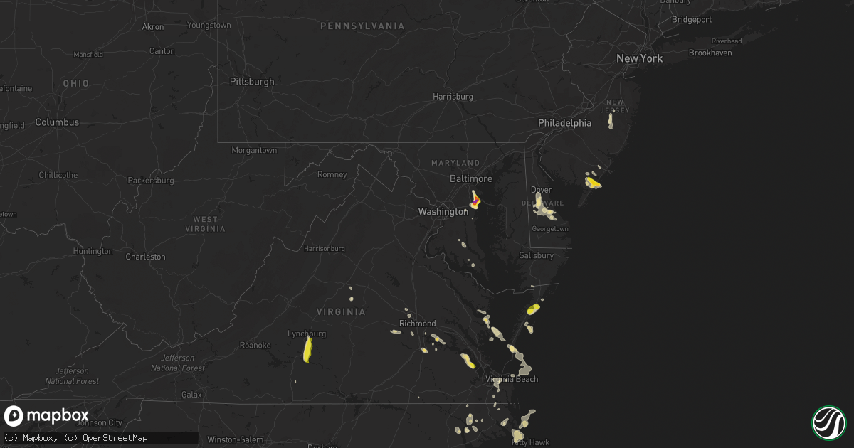
Hail Map in Maryland on July 1, 2020
Get this storm
July 1 map
$229
one time, instant access
Download today. No call, no setup
Keep the $229
Bought the map and want the full workflow? Apply the entire $229 to a subscription within 7 days. None of it is wasted.
Every map, not just this one
This buys you this map. Subscription and you get every map we run, in the markets you choose from a few cities to whole states to nationwide. Plus real-time alerts the moment a storm fires.
Contact data
Name, contact info, occupancy, even credit band for addresses in the footprint. You go from where it hit to who to call.
Become the source they trust
Unlimited branding weather history reports on demand. You already have the documented answer ready for the property owner, and you are the one who showed up with it.
Property data and RoofTrace estimates
Pull up any address you have got, its value and the exact code rules for that jurisdiction, straight from One Click Code. Then RoofTrace estimates the squares, pitch, and roof value, priced the way you price.
Storm reports in Maryland
Maryland
| Date | Description |
|---|---|
| 07/01/20203:13 PM CDT | Golf ball sized hail observed near riva road and forest road. |
| 07/01/20203:11 PM CDT | Reported near the cross section of admiral cochrane drive and solomon's island road. |
| 07/01/20203:09 PM CDT | Ping pong sized hail near the intersection of forest drive and solomons island road |
| 07/01/20203:05 PM CDT | Quarter sized hail near the 500 block of samuel chase way just off route 50. |
| 07/01/20203:02 PM CDT | A local report indicates 1.25 inch wind near 1 NNE PAROLE |
| 07/01/20202:51 PM CDT | Quarter sized hail near the intersection of governor richie hwy and chautaugua road |
| 07/01/20202:50 PM CDT | Quarter sized hail in the vicinity of severna park |
| 07/01/202012:20 PM CDT | Large branch |
| 07/01/20207:29 AM CDT | At 1229 PM EDT, a severe thunderstorm was located over White Point Beach, moving east at 15 mph. HAZARD...60 mph wind gusts and quarter size hail. SOURCE...Radar indicated. IMPACT...Damaging winds will cause some trees and large branches to fall. This could injure those outdoors, as well as damage homes and vehicles. Roadways may become blocked by downed trees. Localized power outages are possible. Unsecured light objects may become projectiles. Locations impacted include... Lexington Park, Chesapeake Ranch Estates, Tall Timbers, Town Creek, Saint Marys City, Saint Marys River, White Point Beach, Cuckold Creek, California, Lusby, Patuxent River Naval Air Station, Drum Point, Dowell, Valley Lee, Great Mills, Redgate, Drayden, Park Hall and Callaway. |
| 06/30/202011:15 PM CDT | At 415 PM EDT, a severe thunderstorm was located over Londontowne, or near Annapolis, moving southwest at 15 mph. HAZARD...60 mph wind gusts and quarter size hail. SOURCE...Radar indicated. IMPACT...Damaging winds will cause some trees and large branches to fall. This could injure those outdoors, as well as damage homes and vehicles. Roadways may become blocked by downed trees. Localized power outages are possible. Unsecured light objects may become projectiles. Locations impacted include... Bowie, Annapolis, Crofton, Mayo, Shady Side, Deale, Upper Marlboro, South River, Rhode River, Parole, Kettering, Londontowne, Edgewater, Riva, Galesville, Highland Beach, Lothian, Davidsonville, Hillsmere Shores and Harwood. |
| 06/30/202011:05 PM CDT | At 405 PM EDT, a severe thunderstorm was located over Parole, or near Annapolis, moving southeast at 10 mph. HAZARD...60 mph wind gusts and quarter size hail. SOURCE...Radar indicated. IMPACT...Damaging winds will cause some trees and large branches to fall. This could injure those outdoors, as well as damage homes and vehicles. Roadways may become blocked by downed trees. Localized power outages are possible. Unsecured light objects may become projectiles. Locations impacted include... Annapolis, Mayo, Rhode River, South River, Parole, Londontowne, Edgewater, Riva, Crownsville and Edgewater Beach. |
| 06/30/202010:56 PM CDT | At 355 PM EDT, a severe thunderstorm was located over Arnold, or over Naval Academy, moving southeast at 25 mph. HAZARD...60 mph wind gusts and quarter size hail. SOURCE...Radar indicated. IMPACT...Damaging winds will cause some trees and large branches to fall. This could injure those outdoors, as well as damage homes and vehicles. Roadways may become blocked by downed trees. Localized power outages are possible. Unsecured light objects may become projectiles. Locations impacted include... Annapolis, Mayo, Naval Academy, Pinehurst, Magothy River, Dobbins Island, Gibson Island, Sillery Bay, Severn River, Severna Park, Arnold, Lake Shore, Parole, Cape St. Claire, Herald Harbor, Crownsville, Highland Beach, Hillsmere Shores, Sherwood Forest and Belvedere Heights. |
| 06/30/202010:30 PM CDT | At 330 PM EDT, a severe thunderstorm was located over Green Haven, or over Riviera Beach, moving southeast at 20 mph. HAZARD...60 mph wind gusts and quarter size hail. SOURCE...Radar indicated. IMPACT...Damaging winds will cause some trees and large branches to fall. This could injure those outdoors, as well as damage homes and vehicles. Roadways may become blocked by downed trees. Localized power outages are possible. Unsecured light objects may become projectiles. Locations impacted include... Annapolis, Riviera Beach, Mayo, Naval Academy, Magothy River, Dobbins Island, Severn River, Pinehurst, Gibson Island, Sillery Bay, Fort Smallwood State Park, Glen Burnie, Severna Park, Pasadena, Arnold, Lake Shore, Parole, Green Haven, Edgewater and Cape St. Claire. |
| 06/30/202010:14 PM CDT | At 314 PM EDT, a severe thunderstorm was located near Hallowing Point, moving southeast at 10 mph. HAZARD...60 mph wind gusts and quarter size hail. SOURCE...Radar indicated. IMPACT...Damaging winds will cause some trees and large branches to fall. This could injure those outdoors, as well as damage homes and vehicles. Roadways may become blocked by downed trees. Localized power outages are possible. Unsecured light objects may become projectiles. Locations impacted include... Hallowing Point, Sheridan Point, Golden Beach, Saint Leonard, Hughesville, Mechanicsville, Charlotte Hall, Aquasco, Benedict, Eagle Harbor, Barstow, Clements, Morganza, Hillville, Sandgates, Oakville, Loveville and Helen. |
| 06/30/20208:07 PM CDT | At 107 PM EDT, a severe thunderstorm was located over Hollywood, or over Leonardtown, moving southeast at 10 mph. HAZARD...60 mph wind gusts and quarter size hail. SOURCE...Radar indicated. IMPACT...Damaging winds will cause some trees and large branches to fall. This could injure those outdoors, as well as damage homes and vehicles. Roadways may become blocked by downed trees. Localized power outages are possible. Unsecured light objects may become projectiles. Locations impacted include... Lexington Park, Leonardtown, Tall Timbers, Town Creek, White Point Beach, California, Patuxent River Naval Air Station, Hollywood, Valley Lee, Tintop Hill, Great Mills, Redgate and Callaway. |
All States Impacted by Hail Map on July 1, 2020
Cities Impacted by Hail Map on July 1, 2020
- Lumberton, MS
- Orange City, FL
- Deltona, FL
- Crowell, TX
- Quanah, TX
- Cedarcreek, MO
- Ballinger, TX
- Paint Rock, TX
- Rowena, TX
- Annapolis, MD
- Edgewater, MD
- Severna Park, MD
- Arnold, MD
- Woodbine, NJ
- Ocean View, NJ
- Estell Manor, NJ
- Lucedale, MS
- Moss Point, MS
- Vancourt, TX
- Greenwood, MS
- Talpa, TX
- Deerfield, KS
- Satanta, KS
- Northport, AL
- Manchester Township, NJ
- Lakehurst, NJ
- Cobbs Creek, VA
- Hallieford, VA
- Hudgins, VA
- Bardwell, KY
- Sidon, MS
- Cruger, MS
- Macon, MS
- Carthage, MS
- Bush, LA
- Ulysses, KS
- Ozona, TX
- Cape Charles, VA
- Hermitage, MO
- Viola, AR
- Salem, AR
- Wingo, KY
- Norway, KS
- Courtland, KS
- Westbrook, TX
- Loraine, TX
- Powhatan, VA
- Eufaula, AL
- Chaseley, ND
- Harvey, ND
- Andalusia, AL
- Altavista, VA
- Gladys, VA
- Lynchburg, VA
- Rustburg, VA
- San Angelo, TX
- Williford, AR
- Charles City, VA
- Dyersburg, TN
- De Kalb, MS
- Collinsville, MS
- Daleville, MS
- Porterville, MS
- Bailey, MS
- Eden, TX
- Picayune, MS
- Perkinston, MS
- Deepwater, MO
- Morton, MS
- Lakin, KS
- Manila, AR
- Lauderdale, MS
- Cuba, AL
- Ashford, AL
- Cottonwood, AL
- Forgan, OK
- Sonora, TX
- Leoti, KS
- Cando, ND
- Egeland, ND
- Louisville, MS
- Noxapater, MS
- Dryden, TX
- Winters, TX
- Greenwood, DE
- Milford, DE
- Houston, DE
- Colorado City, TX
- Eupora, MS
- Mathiston, MS
- Hopkins, SC
- Columbia, SC
- Eastover, SC
- Lena, MS
- Eldorado, TX
- Moscow, KS
- Bainbridge, GA
- Colquitt, GA
- Scottsville, VA
- Caulfield, MO
- Salem, CT
- Old Lyme, CT
- East Haddam, CT
- Christoval, TX
- Virginia Beach, VA
- Evington, VA
- Hardy, AR
- Lincoln, DE
- Bowdon, ND
- Disputanta, VA
- Camden, AL
- Sedalia, KY
- Dora, MO
- Sweetwater, TX
- Chesapeake, VA
- Haines City, FL
- Winter Haven, FL
- Dundee, FL
- Kismet, KS
- Emporia, KS
- Roach, MO
- Rotan, TX
- McLain, MS
- Atlanta, MO
- Mechanicsville, MD
- Charlotte Hall, MD
- Hughesville, MD
- Onley, VA
- Accomac, VA
- Council Grove, KS
- White City, KS
- Letohatchee, AL
- Hardyville, VA
- Deltaville, VA
- Wake, VA
- Colchester, CT
- Marion, KS
- Lawn, TX
- Ovalo, TX
- Windsor, MO
- Wheatland, MO
- Edwards, MO
- Brewton, AL
- Diberville, MS
- Biloxi, MS
- Gulfport, MS
- New Egypt, NJ
- Dover, DE
- Harrington, DE
- Camden Wyoming, DE
- Felton, DE
- Viola, DE
- Magnolia, DE
- Jackson, AL
- Sainte Genevieve, MO
- Gates, NC
- Corapeake, NC
- Calico Rock, AR
- Prairie, MS
- Gatesville, NC
- Tyner, NC
- Sunbury, NC
- Belvidere, NC
- Hobbsville, NC
- Hertford, NC
- Whiteville, TN
- Somerville, TN
- Roscoe, TX
- Carlsbad, TX
- Cathay, ND
- Leonard, MO
- Pulaski, MS
- Camden, NC
- Aspermont, TX
- Samson, AL
- Oberon, ND
- Sea Isle City, NJ
- Strathmere, NJ
- Marmora, NJ
- Ocean City, NJ
- Cape May Court House, NJ
- Mountain View, AR
- Windsor, NC
- Hattiesburg, MS
- Jarvisburg, NC
- Grandy, NC
- Powells Point, NC
- Norton, TX
- Pasadena, MD
- Davidsonville, MD
- Crownsville, MD
- Riva, MD
- Melbourne, AR
- Vincentown, NJ
- Ava, MO
- Chatom, AL
- Onancock, VA
- Parksley, VA
- Melfa, VA
- Maben, MS
- Spring Grove, VA
- Walnut Grove, MS
- Brooksville, MS
- Coffeeville, MS
- Bells, TN
- Mize, MS
- Emelle, AL
- Kendall, KS
- Drew, MS
- Starkville, MS
- Gordon, AL
- Jakin, GA
- Flemington, MO
- Lebanon, MO
- Phillipsburg, MO
- Mobile, AL
- Brixey, MO
- Wasola, MO
- Benton, MS
- Bentonia, MS
- Ellendale, DE
- Eldorado, OK
- Meridian, MS
- Senatobia, MS
- Greenville, AL
- Preston, CT
- Ledyard, CT
- West Plains, MO
- Moody, MO
- Gamaliel, AR
- Pine Apple, AL
- Valdosta, GA
- Leonardtown, MD
- Elk City, OK
- Dexter, MO
- Novice, TX
- Diggs, VA
- Moon, VA
- Gwynn, VA
- Newton, AL
- New Rockford, ND
- Mountain Home, AR
- Gassville, AR
- Rueter, MO
- Bradleyville, MO
- Kissee Mills, MO
- Baker, FL
- Holt, FL
- Egg Harbor Township, NJ
- Toone, TN
- Medon, TN
- Silas, AL
- Bowie, MD
- Upper Marlboro, MD
- Prince George, VA
- Fort Lee, VA
- Petersburg, VA
- Sublette, KS
- Sheyenne, ND
- Poughkeepsie, AR
- Bay Springs, MS
- Edenton, NC
- Saraland, AL
- Daphne, AL
- Warsaw, MO
- Greenbush, VA
- Forest, MS
- Stockton, AL
- Vancleave, MS
- Sturkie, AR
- Theodore, AL
- Brandon, MS
- Canton, MS
- Corolla, NC
- Pearl, IL
- Pottersville, MO
- Coila, MS
- Bradford, AR
- Leeton, MO
- Warrensburg, MO
- Shiloh, NC
- Harbinger, NC
- Boston, GA
- Thomasville, GA
- Pavo, GA
- Yaphank, NY
- Ridge, NY
- Manorville, NY
- Shirley, NY
- Citronelle, AL
- Leakesville, MS
- Maddock, ND
- Blakely, GA
- McCool, MS
- Millry, AL
- Harrellsville, NC
- Cofield, NC
- Colerain, NC
- Aberdeen, MS
- Birdsnest, VA
- Painter, VA
- Deer Park, AL
- Fruitdale, AL
- Vinegar Bend, AL
- Campbell, MO
- Qulin, MO
- Poplar Bluff, MO
- Livingston, AL
- Bolivar, MO
- Ravenden, AR
- Woodbine, KS
- Philadelphia, MS
- Cross Timbers, MO
- Chesterfield, VA
- Richmond, VA
- Dudley, MO
- Bloomfield, MO
- Arlington, KY
- Smithville, AR
- Cunningham, KY
- Topping, VA
- White Stone, VA
- Opp, AL
- Milton, FL
- Shawboro, NC
- Kosciusko, MS
- Sallis, MS
- Glen Allen, VA
- Grenada, MS
- Scobey, MS
- Tillatoba, MS
- Pelahatchie, MS
- New Madrid, MO
- Clinton, MO
- Scandia, KS
- Jamestown, KS
- Cuthbert, GA
- Red Level, AL
- Surry, VA
- Smithfield, VA
- Carrollton, VA
- Blackwell, MO
- Martin, TN
- Dukedom, TN
- Cottage Grove, TN
- Puryear, TN
- Java, VA
- Chatham, VA
- Water Valley, MS
- Emporia, VA
- Forest Home, AL
- Georgiana, AL
- Beaumont, MS
- Geneva, FL
- Louin, MS
- Raleigh, MS
- Callao, MO
- Bevier, MO
- Palmyra, MO
- Jackson, NJ
- Preston, MO
- Kinston, AL
- Bethel, MO
- Buffalo, MO
- Adel, GA
- Hahira, GA
- Long Beach, MS
- Woodland, MS
- Houston, MS
- Coffeeville, AL
- Thomasville, AL
- Mertzon, TX
- Moseley, VA
- Mansfield, MO
- Bernie, MO
- Parma, MO
- Bexar, AR
- Elizabeth, AR
- Elrod, AL
- Gordo, AL
- Heber Springs, AR
- Drasco, AR
- Higden, AR
- Abbeville, AL
- Abita Springs, LA
- Ewing, MO
- Vardaman, MS
- Calhoun City, MS
- Clinton, KY
- Mayfield, KY
- Bolivar, TN
- Grove Hill, AL
- Norfolk, VA
- Matthews, MO
- Itta Bena, MS
- Winona, MS
- Midlothian, VA
- Sturgis, MS
- Murray, KY
- Enid, MS
- Lothian, MD
- Jonesboro, AR
- Osceola, AR
- Herington, KS
- Elkland, MO
- Conway, MO
- Yellville, AR
- Columbia, AL
- Puxico, MO
- Paragould, AR
- Uncasville, CT
- Oakdale, CT
- Moyock, NC
- Milton, DE
- Dunnegan, MO
- Fair Play, MO
- Solomon, KS
- Oxford, MS
- Charleston, MS
- Covington, TN
- Sterling City, TX
- Theodosia, MO
- Protem, MO
- Killingworth, CT
- Higganum, CT
- Powhatan, AR
- Crescent City, FL
- Charlottesville, VA
- Tibbie, AL
- Pass Christian, MS
- Hazel, KY
- Evergreen, AL
- Niangua, MO
- Tunas, MO
- Macks Creek, MO
- Loxahatchee, FL
- Grand Bay, AL
- New Orleans, LA
- Pickens, MS
- Lexington, MS
- Concordia, KS
- East Prairie, MO
- Dundalk, MD
- Durant, MS
- Tribune, KS
- Onemo, VA
- Roby, TX
- Marion Station, MD
- Paris, TN
- Neely, MS
- Leroy, AL
- Chapman, KS
- Anaconda, MT
- Port Haywood, VA
- Susan, VA
- Tecumseh, MO
- Jewell, KS
- Gales Ferry, CT
- Bertrand, MO
- Oakland, MS
- Chunchula, AL
- Waldorf, MD
- Kiln, MS
- Camden, TN
- Oldfield, MO
- Fessenden, ND
- Fulton, KY
- Hickory Valley, TN
- Donalsonville, GA
- Brinson, GA
- Iron City, GA
- Hopewell, VA
- Palmersville, TN
- Chester, CT
- Woodside, DE
- Chadwick, MO
- Henrico, VA
- Louisburg, MO
- Coffee Springs, AL
- Warwick, ND
- McEwen, TN
- Lakeland, GA
- Ray City, GA
- Essex, MO
- Stonewall, MS
- Weems, VA
- Irvington, VA
- Lancaster, VA
- Wallops Island, VA
- Plains, KS
- Winchester, IL
- Pontotoc, MS
- Bono, AR
- Cedarbluff, MS
- Vaiden, MS
- Millersville, MD
- Glen Burnie, MD
- Mays Landing, NJ
- Cameron, SC
- Saucier, MS
- Fredericktown, MO
- Medford, NY
- Lisman, AL
- Windyville, MO
- Elmer, MO
- Enterprise, KS
- Farmington, MO
- Shuqualak, MS
- Clewiston, FL
- Batesville, AR
- Long Island, VA
- Holcomb, KS
- Goodman, MS
- West, MS
- Camden, MS


