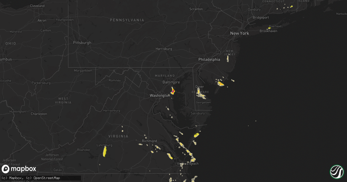
Hail Map on July 1, 2020
Get this storm
July 1 map
$229
one time, instant access
Download today. No call, no setup
Keep the $229
Bought the map and want the full workflow? Apply the entire $229 to a subscription within 7 days. None of it is wasted.
Every map, not just this one
This buys you this map. Subscription and you get every map we run, in the markets you choose from a few cities to whole states to nationwide. Plus real-time alerts the moment a storm fires.
Contact data
Name, contact info, occupancy, even credit band for addresses in the footprint. You go from where it hit to who to call.
Become the source they trust
Unlimited branding weather history reports on demand. You already have the documented answer ready for the property owner, and you are the one who showed up with it.
Property data and RoofTrace estimates
Pull up any address you have got, its value and the exact code rules for that jurisdiction, straight from One Click Code. Then RoofTrace estimates the squares, pitch, and roof value, priced the way you price.
States Impacted by Hail Map on July 1, 2020
Storm reports
Georgia
| Date | Description |
|---|---|
| 07/01/20203:25 PM CDT | Report of a tree on powerlines near bemiss and new bethel rd. |
| 07/01/20203:18 PM CDT | Report of a tree down near hamilton street. |
| 07/01/20203:18 PM CDT | Report of tree down near wood valley drive. |
| 07/01/20203:16 PM CDT | Report of a tree down near loyda rd. |
| 07/01/20203:08 PM CDT | Report of a tree down on morven rd. |
| 07/01/20202:40 PM CDT | Report of trees down near old monticello rd and pinetree blvd. |
| 07/01/20201:47 PM CDT | Damage to the coca cola plant on highway 27 north about 3 miles north of west bainbridge. |
| 07/01/20201:42 PM CDT | Tree down on a power line. |
| 07/01/20201:40 PM CDT | Highway sign knocked down by wind at the intersection of hwy 319 and hwy 15. |
| 07/01/20201:11 PM CDT | One tree down in blakely. |
| 07/01/202012:49 PM CDT | Trees and power lines reported down at various locations across the county. |
| 07/01/202012:49 PM CDT | Report of trees and powerlines down on wadsworth drive. |
| 07/01/202012:05 PM CDT | Tree downed onto a home on the 1100 block of sherbrooke drive. |
| 07/01/20207:45 AM CDT | At 1245 PM EDT, a severe thunderstorm was located near Jack Brown Estates, or 8 miles east of Roberta, moving east at 40 mph. HAZARD...60 mph wind gusts. SOURCE...Radar indicated. IMPACT...Expect damage to roofs, siding, and trees. Locations impacted include... Macon, Jeffersonville, Warner Robins, Centerville, Byron, Robins Air Force Base, Marion, Tarversville, District Path, Powerville, Skipperton, Jack Brown Estates, Bullard, Rutland, Fitzpatrick, Ripley, Lakewood, Huber, Dry Branch and Lizella. |
| 07/01/202012:56 AM CDT | At 556 PM EDT, a severe thunderstorm was located near Bryceville, or 15 miles southwest of Callahan, moving east at 30 mph. Additional storms were over western Nassau county moving east at 30 mph. HAZARD...60 mph wind gusts and penny size hail. SOURCE...Radar indicated. IMPACT...Expect damage to roofs, siding, and trees. Locations impacted include... Jacksonville, Fernandina Beach, Callahan, Jacksonville International Arpt, Unf, Arlington, Yulee, Neptune Beach, Baymeadows and Cisco Gardens. |
| 06/30/202011:16 PM CDT | At 415 PM EDT, a severe thunderstorm was located near I-75 At Exit 16, or near Valdosta, moving east at 25 mph. HAZARD...60 mph wind gusts. SOURCE...Radar indicated. IMPACT...Expect damage to roofs, siding, and trees. Locations impacted include... Lake Park, Valdosta, Hahira, Moody Air Force Base, I-75 At Exit 16, Remerton, Dasher, Naylor, Greenwood, Barretts, Twin Lakes, Valdosta Regional Airport, Kinderlou, Clyattville, I-75 At Exit 22, I-75 At Exit 11 and Stockton. |
| 06/30/202010:40 PM CDT | At 340 PM EDT, a severe thunderstorm was located near Pavo, or 11 miles northwest of Quitman, moving east at 40 mph. HAZARD...60 mph wind gusts. SOURCE...Radar indicated. IMPACT...Expect damage to roofs, siding, and trees. Locations impacted include... Valdosta, Quitman, Hahira, Pavo, Moody Air Force Base, I-75 At Exit 16, Remerton, Dasher, Morven, Barwick, Cecil, Barney, Barretts, Oaklawn, Valdosta Regional Airport, Kinderlou, I-75 At Exit 29, Brooks Co A/p, Blue Springs and Hollis. |
| 06/30/202010:01 PM CDT | At 301 PM EDT, a severe thunderstorm was located over Bainbridge, moving southeast at 30 mph. HAZARD...60 mph wind gusts. SOURCE...Radar indicated. IMPACT...Expect damage to roofs, siding, and trees. Locations impacted include... Bainbridge, Cairo, Whigham, West Bainbridge, Climax, Calvary, Reno, Grady Co A/p, Princes Still and Nickleville. |
| 06/30/20209:53 PM CDT | At 253 PM EDT/153 PM CDT/, a severe thunderstorm was located 14 miles northeast of Marianna, moving southeast at 30 mph. HAZARD...60 mph wind gusts. SOURCE...Radar indicated. IMPACT...Expect damage to roofs, siding, and trees. Locations impacted include... Chattahoochee, Malone, Sneads, Grand Ridge, Greenwood, Bascom, Seminole State Park, Steam Mill, Desser, Reynoldsville, Lovedale, Haynes, Drakes Still, Dellwood, Riverturn, Two Egg, Hornsville, Fairchild, Buena Vista and Lake Seminole. |
| 06/30/20209:38 PM CDT | At 238 PM EDT, a severe thunderstorm was located over Wrightsville, moving east at 35 mph. HAZARD...60 mph wind gusts and nickel size hail. SOURCE...Radar indicated. IMPACT...Expect damage to roofs, siding, and trees. Locations impacted include... Wrightsville, Wadley, Harrison, Summertown, Kite, Spann, Donovan, Modoc, Canoochee, Blundale, Pringle, Three Points, Dellwood, New Home and Colemans Lake. |
| 06/30/20208:27 PM CDT | At 127 PM EDT, a severe thunderstorm was located over Shellman, or 8 miles west of Dawson, moving east at 35 mph. HAZARD...60 mph wind gusts and penny size hail. SOURCE...Radar indicated. IMPACT...Expect damage to roofs, siding, and trees. Locations impacted include... Dawson, Leesburg, Albany, Shellman, Smithville, East Albany, Turner City, Marine Corps Logistics Base, Sasser, Bronwood, Parrott, Chokee, Stocks, Radium Springs, Forrester, Lockett Crossing, South Albany, Southwest Ga Regional A/P, Palmyra and Clarks Mill. |
Mississippi
| Date | Description |
|---|---|
| 07/01/20206:30 PM CDT | Tree down on graham rd. |
| 07/01/20206:15 PM CDT | Large tree down on county road 544 and another tree down on county road 518. |
| 07/01/20206:15 PM CDT | Power lines down on county roads 548 and 500 south of kossuth. |
| 07/01/20206:10 PM CDT | Numerous large branches down across town. |
| 07/01/20203:39 AM CDT | At 838 PM CDT, severe thunderstorms were located along a line extending from near Little Rock to near Forest to Fannin, moving south at 40 mph. HAZARD...60 mph wind gusts and penny size hail. SOURCE...Radar indicated. IMPACT...Expect damage to roofs, siding, and trees. Severe thunderstorms will be near... Pulaski around 845 PM CDT. Homewood around 850 PM CDT. Pineville and Burns around 900 PM CDT. Raleigh around 910 PM CDT. Cato, Johns and Rose Hill around 915 PM CDT. Bay Springs, Center Ridge and Piney Woods around 920 PM CDT. Orange around 925 PM CDT. Mendenhall and Martinville around 930 PM CDT.Other locations impacted by these severe thunderstorms includeSylvarena, Mize, Louin, Puckett, Polkville, D'Lo, Chunky, Montrose,Braxton and Hickory. |
| 07/01/20203:11 AM CDT | At 810 PM CDT, severe thunderstorms were located along a line extending from near Forestdale to Dowdville to near Farmhaven, moving south at 35 mph. HAZARD...60 mph wind gusts and penny size hail. SOURCE...Radar indicated. IMPACT...Expect damage to roofs, siding, and trees. Locations impacted include... Brandon, Canton, Forest, Morton, Prospect, Harperville, Neshoba, Decatur, Pelahatchie, Leesburg, Farmhaven, Goshen Springs, Ludlow, Sharon, Forkville, Pisgah, Branch, Conehatta, Herbert Springs and Stratton. |
| 07/01/20202:31 AM CDT | At 731 PM CDT, severe thunderstorms were located along a line extending from 9 miles northeast of Zama to Kosciusko to near Mcmillan, moving south at 45 mph. HAZARD...60 mph wind gusts and penny size hail. SOURCE...Radar indicated. IMPACT...Expect damage to roofs, siding, and trees. Severe thunderstorms will be near... Smyrna around 740 PM CDT. Pickens, Singleton and Renfroe around 750 PM CDT. Cameron and Vaughan around 755 PM CDT. Carthage, Camden and Way around 800 PM CDT. Sharon, Tuscola and Madden around 810 PM CDT. Farmhaven around 815 PM CDT.Other locations impacted by these severe thunderstorms include Lena,Walnut Grove, Sallis, Redwater and Standing Pine. |
| 07/01/202012:32 AM CDT | At 532 PM CDT, a severe thunderstorm was located over Burnside, or near Philadelphia, moving east at 20 mph. HAZARD...60 mph wind gusts and nickel size hail. SOURCE...Radar indicated. IMPACT...Expect damage to roofs, siding, and trees. This severe thunderstorm will be near... Burnside around 535 PM CDT. Stallo around 540 PM CDT. Forestdale around 600 PM CDT. Nanih Waiya around 605 PM CDT.Other locations impacted by this severe thunderstorm includeNoxapater and Tucker. |
| 06/30/202011:23 PM CDT | At 423 PM CDT, a severe thunderstorm was located near Tillmans Corner, moving south at 35 mph. HAZARD...60 mph wind gusts. SOURCE...Radar indicated. IMPACT...Expect damage to roofs, siding, and trees. Locations impacted include... Theodore, Grand Bay, Bayou La Batre, Dauphin Island, Coden, Fort Morgan and Alabama Port. |
| 06/30/20209:20 PM CDT | At 219 PM CDT, severe thunderstorms were located along a line extending from Homewood to near Raleigh, moving east at 25 mph. HAZARD...60 mph wind gusts and nickel size hail. SOURCE...Radar indicated. IMPACT...Expect damage to roofs, siding, and trees. Severe thunderstorms will be near... Center Ridge around 230 PM CDT. Pineville around 235 PM CDT. Stringer, Lawrence and Bay Springs around 255 PM CDT. Roberts, Turnerville, Garlandville and Vernon around 300 PM CDT.Other locations impacted by these severe thunderstorms includeSylvarena, Lake, Montrose and Louin. |
| 06/30/20208:52 PM CDT | Tree down on utility equipment. |
| 06/30/20208:51 PM CDT | Tree down across power lines along 541 near the strong river bridge. |
| 06/30/20208:39 PM CDT | Trees and power lines down. |
| 06/30/20208:35 PM CDT | Trees down in lake. |
| 06/30/20208:35 PM CDT | Tree down near oakdale and wagoner. |
| 06/30/20207:55 PM CDT | Tree down on ben lucket rd. |
| 06/30/20207:52 PM CDT | Tree down on marty steward rd near the arlington community. |
| 06/30/20207:50 PM CDT | Tree down on highway 395. |
| 06/30/20207:45 PM CDT | Two trees down in leake county. |
| 06/30/20207:25 PM CDT | Large limb down on plum rd reported by broadcast media. |
| 06/30/20207:15 PM CDT | Tree down on keytown rd. |
Illinois
| Date | Description |
|---|---|
| 07/01/20202:00 PM CDT | Parking overhang blown off at hurricane/hafer rd. |
Tennessee
| Date | Description |
|---|---|
| 07/01/20204:25 PM CDT | Trees down and power lines down on pleasant ridge west of big creek church. |
| 07/01/20204:15 PM CDT | Large tree and power lines down blocking road on south lucy road southwest of millington. |
| 07/01/20203:15 PM CDT | Large tree and power lines down blocking road on south lucy road in millington. |
Kentucky
| Date | Description |
|---|---|
| 07/01/20203:34 AM CDT | At 834 PM EDT, a severe thunderstorm was located near Carlisle, moving southwest at 5 mph. HAZARD...60 mph wind gusts and nickel size hail. SOURCE...Radar indicated. IMPACT...Expect damage to roofs, siding, and trees. Locations impacted include... Carlisle, Jackstown, Plum, Weston, Bunker Hill, East Union, Little Rock and Moorefield. |
Minnesota
| Date | Description |
|---|---|
| 06/30/202010:43 PM CDT | At 343 AM CDT, severe thunderstorms were located along a line extending from 8 miles east of Kent to near Fergus Falls, moving northeast at 30 mph. HAZARD...60 mph wind gusts. SOURCE...Trained weather spotters. IMPACT...Expect damage to roofs, siding, and trees. Severe thunderstorms will be near... Fergus Falls around 345 AM CDT. Underwood around 355 AM CDT. Lawndale around 400 AM CDT. Rothsay and Phelps around 405 AM CDT. Ottertail Lake, Pelican Rapids and Erhard around 415 AM CDT.Other locations impacted by these severe thunderstorms include FergusFalls Airport.This includes Interstate 94 in Minnesota between mile markers 27 and65. |
Louisiana
| Date | Description |
|---|---|
| 07/01/20203:36 PM CDT | Broadcast media relayed pictures of damage to an awning carport covering. Time estimated by radar. |
South Carolina
| Date | Description |
|---|---|
| 06/30/202010:18 PM CDT | At 318 PM EDT, a severe thunderstorm was located 7 miles southeast of Elgin, or 11 miles north of McEntire Air Base, moving southeast at 15 mph. HAZARD...60 mph wind gusts and penny size hail. SOURCE...Radar indicated. IMPACT...Expect damage to roofs, siding, and trees. Locations impacted include... Columbia, Eastover, Boykin, Fort Jackson McCrady Training Center, Dinkins Mill, Wateree River Correctional Institution, Rembert, Fort Jackson Wildcat Road and Stateburg. |
| 06/30/202010:01 PM CDT | At 300 PM EDT, a severe thunderstorm was located 15 miles east of Greenville Downtown, or 4 miles east of Five Forks, moving southeast at 20 mph. HAZARD...60 mph wind gusts and quarter size hail. SOURCE...Radar indicated. IMPACT...Minor hail damage to vehicles is expected. Expect wind damage to trees and power lines. Locations impacted include... Five Forks, Woodruff, Reidville, Fountain Inn and Mauldin. |
North Carolina
| Date | Description |
|---|---|
| 07/01/20206:15 PM CDT | Roof and siding damage to one home and numerous branches and limbs off trees. One small tree was uprooted on happy home road. |
| 07/01/20202:25 AM CDT | At 725 PM EDT, a severe thunderstorm was located over Tyner, or near Ryland, moving southeast at 20 mph. HAZARD...60 mph wind gusts and quarter size hail. SOURCE...Radar indicated. IMPACT...Minor damage to vehicles is possible. Expect wind damage to trees and powerlines. This severe thunderstorm will be near, Belvidere around 730 PM EDT. Rockyhock around 735 PM EDT. Valhalla around 745 PM EDT. Cape Colony around 815 PM EDT. Snug Harbor around 820 PM EDT.Other locations impacted by this severe thunderstorm include GoosePond, Holiday Island, Gliden, Drummond Point, Newsome Store,Arrowhead Beach, Saint Johns, Mount Gould, Hancock and YeopimStation. |
Vermont
| Date | Description |
|---|---|
| 07/01/202012:07 AM CDT | At 507 PM EDT, a severe thunderstorm was located near Norton, moving southwest at 20 mph. HAZARD...60 mph wind gusts and quarter size hail. SOURCE...Radar indicated. IMPACT...Minor hail damage to vehicles is possible. Expect wind damage to trees and powerlines. Locations impacted include... Newport City, Orleans, Derby Center, Charleston, Newport Town, Westmore, Orleans Village, Glover, Brownington, Coventry, Barton, Troy, Brownington Village, Irasburg, Derby Line Village, Morgan, Warren Gore, Newport Center, North Troy Village and Averys Gore. |
Connecticut
| Date | Description |
|---|---|
| 07/01/20202:20 PM CDT | Tree and wires down on hillcrest avenue near avery hill road |
| 07/01/20201:56 PM CDT | Quarter size hail reported by salem valley farms. |
| 06/30/202010:59 PM CDT | At 359 PM EDT, a severe thunderstorm was located over Ashford, or 8 miles north of Mansfield, moving east at 20 mph. HAZARD...60 mph wind gusts and quarter size hail. SOURCE...Radar indicated. IMPACT...Expect wind damage to trees and power lines. Minor hail damage to vehicles is possible. Locations impacted include... Mansfield, Stafford, Woodstock, Willington, Ashford, Pomfret, Chaplin, Eastford and Union. |
| 06/30/202010:24 PM CDT | At 323 PM EDT, a severe thunderstorm was located near Ledyard Center, or near Norwich, moving east at 30 mph. HAZARD...Ping pong ball size hail. SOURCE...Radar indicated. IMPACT...People and animals outdoors will be injured. Expect damage to roofs, siding, windows, and vehicles. This severe thunderstorm will be near... Griswold around 340 PM EDT. Voluntown around 350 PM EDT. |
| 06/30/20209:50 PM CDT | At 250 PM EDT, a severe thunderstorm was located over Salem, moving east at 30 mph. HAZARD...Ping pong ball size hail. SOURCE...Radar indicated. IMPACT...People and animals outdoors will be injured. Expect damage to roofs, siding, windows, and vehicles. Locations impacted include... Norwich, New London, Colchester, Groton, Salem, Waterford, East Lyme, Ledyard, Griswold, East Haddam, Old Lyme, Lebanon, Preston, Lisbon and Sprague. |
| 06/30/20209:29 PM CDT | At 228 PM EDT, a severe thunderstorm was located over Durham, moving southeast at 15 mph. HAZARD...Quarter size hail. SOURCE...Radar indicated. IMPACT...Minor damage to vehicles is possible. Locations impacted include... Middletown, Wallingford, Guilford, Clinton, Old Saybrook, Durham, Chester, Hartford, East Lyme, North Branford, East Haddam, Haddam, Old Lyme, Westbrook and Killingworth. |
Iowa
| Date | Description |
|---|---|
| 06/30/20208:49 PM CDT | At 148 AM CDT, severe thunderstorms were located along a line extending from Farragut to near Riverton to near Hamburg to near Peru, moving southeast at 35 mph. HAZARD...60 mph wind gusts. SOURCE...Radar indicated. IMPACT...Expect damage to roofs, siding, and trees. Locations impacted include... Tarkio, Rock Port, Fairfax, Rockport, Elmo, Braddyville, Westboro, Watson, Blanchard, Indian Cave State Park and Phelps City.This includes Interstate 29 between mile markers 100 and 123. |
| 06/30/20208:36 PM CDT | At 135 AM CDT, a severe thunderstorm was located near Riverton, or 22 miles northwest of Tarkio, moving southeast at 40 mph. HAZARD...60 mph wind gusts. SOURCE...Public. IMPACT...Expect damage to roofs, siding, and trees. Locations impacted include... Hamburg, Sidney, Farragut, Riverton, Northboro, Blanchard and Waubonsie State Park.This includes Interstate 29 between mile markers 4 and 7. |
Alabama
| Date | Description |
|---|---|
| 07/01/20205:26 PM CDT | Tree on home on glen chambers rd via emergency manager. Also reports of a couple trees down along the road and pictures of a chicken coop roof partially blown off. Pict |
| 07/01/20204:38 PM CDT | Two large trees blown down... Resulting in roof damage to a residence. |
| 07/01/20204:31 PM CDT | Large tree blown down a quarter mile south of daphne on highway 98. |
| 07/01/20202:33 AM CDT | At 732 PM CDT, severe thunderstorms were located along a line extending from near Brooksville to near Vernon to 8 miles southwest of Center Ridge, moving south at 35 mph. HAZARD...60 mph wind gusts and nickel size hail. SOURCE...Radar indicated. IMPACT...Expect damage to roofs, siding, and trees. Severe thunderstorms will be near... Nanih Waiya and Macon around 745 PM CDT. Stallo and Gholson around 750 PM CDT. Preston and Burnside around 755 PM CDT. Philadelphia, Bluff Springs and Paulette around 805 PM CDT. Forestdale around 810 PM CDT. De Kalb and Bethsaida around 815 PM CDT.Other locations impacted by these severe thunderstorms includeNoxapater, Tucker, Shuqualak and Scooba. |
| 07/01/20201:14 AM CDT | At 614 PM CDT, a severe thunderstorm was located near Liberty, or 10 miles northwest of Meridian Station, moving east at 20 mph. HAZARD...60 mph wind gusts and nickel size hail. SOURCE...Radar indicated. IMPACT...Expect damage to roofs, siding, and trees. Locations impacted include... Lauderdale, Meridian Station, De Kalb, Liberty, Blackwater, Tamola, Daleville, Electric Mills, Porterville, Prismatic, Martin and I 20 Welcome Center At Cuba. |
| 06/30/202011:37 PM CDT | At 436 PM CDT, a severe thunderstorm was located over River Falls, or near Andalusia, moving southeast at 25 mph. HAZARD...60 mph wind gusts. SOURCE...Radar indicated. IMPACT...Expect damage to roofs, siding, and trees. Locations impacted include... Andalusia, River Falls, Red Level, Heath and Gantt. |
| 06/30/202011:27 PM CDT | At 426 PM CDT, a severe thunderstorm was located over Fairhope, moving south at 30 mph. HAZARD...60 mph wind gusts. SOURCE...Radar indicated. IMPACT...Expect damage to roofs, siding, and trees. Locations impacted include... Daphne, Fairhope, Foley, Spanish Fort, Robertsdale, Point Clear, Loxley, Magnolia Springs, Bon Secour, Summerdale, Silverhill and Elberta. |
| 06/30/202011:08 PM CDT | At 408 PM CDT, a severe thunderstorm was located 4 miles southwest of Georgiana, or 14 miles northeast of Evergreen, moving southeast at 15 mph. HAZARD...60 mph wind gusts. SOURCE...Radar indicated. IMPACT...Expect damage to roofs, siding, and trees. Locations impacted include... Georgiana, McKenzie and Red Level. |
| 06/30/202011:01 PM CDT | At 401 PM CDT, a severe thunderstorm was located 5 miles northeast of Semmes, or 8 miles west of Saraland, moving south at 30 mph. HAZARD...60 mph wind gusts. SOURCE...Radar indicated. IMPACT...Expect damage to roofs, siding, and trees. Locations impacted include... Midtown Mobile, Downtown Mobile, Prichard, Tillmans Corner, Saraland, Theodore, Chickasaw, Satsuma, Grand Bay, Creola, Chunchula, Axis, Semmes, Tanner Williams, I65 And I165, Mobile Regional Airport, Wilmer, I65 And AL 158 and I10 And I65. |
| 06/30/202010:56 PM CDT | At 356 PM CDT, a severe thunderstorm was located 11 miles east of Georgiana, or 13 miles south of Greenville, moving southeast at 20 mph. HAZARD...60 mph wind gusts. SOURCE...Radar indicated. IMPACT...Expect damage to roofs, siding, and trees. Locations impacted include... Dozier and Gantt. |
| 06/30/202010:10 PM CDT | At 310 PM CDT, severe thunderstorms were located along a line extending from Camden to 5 miles west of Greenville, moving southeast at 15 mph. HAZARD...60 mph wind gusts. SOURCE...Radar indicated. IMPACT...Expect damage to roofs, siding, and trees. Locations impacted include... Greenville, Camden, Georgiana, Beatrice, Vredenburgh and Pine Apple. |
| 06/30/202010:05 PM CDT | At 305 PM CDT, a severe thunderstorm was located 6 miles west of Calvert, or 9 miles northeast of Citronelle, moving southeast at 20 mph. HAZARD...60 mph wind gusts. SOURCE...Radar indicated. IMPACT...Expect damage to roofs, siding, and trees. Locations impacted include... Satsuma, Creola, Stockton, Axis, Mount Vernon, Calvert, McIntosh, I65 And AL 225 and Movico. |
| 06/30/20209:29 PM CDT | At 228 PM EDT, a severe thunderstorm was located near Donalsonville, moving east at 45 mph. HAZARD...60 mph wind gusts. SOURCE...Radar indicated. IMPACT...Expect damage to roofs, siding, and trees. Locations impacted include... Colquitt, Bainbridge, Donalsonville, West Bainbridge, Iron City, Brinson, Hanover, Ausmac, Babcock, Little Hope, Mayhaw, Decatur Co A/P, Boykin, Sharphagen, Donaldsonville A/P, Bellview, Vada, Davis Park, Lela and Eldorendo. |
| 06/30/20209:07 PM CDT | At 207 PM CDT, a severe thunderstorm was located 4 miles south of Silas, or 17 miles north of Chatom, moving southeast at 30 mph. HAZARD...60 mph wind gusts. SOURCE...Radar indicated. IMPACT...Expect damage to roofs, siding, and trees. Locations impacted include... Chatom, Millry and Silas. |
| 06/30/20208:41 PM CDT | At 141 PM CDT, a severe thunderstorm was located 6 miles southwest of Coffeeville, or 16 miles northeast of Chatom, moving south at 15 mph. HAZARD...60 mph wind gusts. SOURCE...Radar indicated. IMPACT...Expect damage to roofs, siding, and trees. Locations impacted include... Saint Stephens and Coffeeville. |
| 06/30/20208:20 PM CDT | At 120 PM CDT, a severe thunderstorm was located 8 miles east of Coffeeville, or 10 miles west of Grove Hill, moving southeast at 15 mph. HAZARD...60 mph wind gusts. SOURCE...Radar indicated. IMPACT...Expect damage to roofs, siding, and trees. Locations impacted include... Grove Hill. |
New Jersey
| Date | Description |
|---|---|
| 07/01/20203:10 PM CDT | Multiple reports of quarter size hail in ocean city. Time estimated from radar. |
| 07/01/20202:45 PM CDT | Tree down on the garden state parkway. Time estimated from radar. |
| 07/01/20202:40 PM CDT | Golf ball sized hail reported in petersburg. Pictures received via social media. |
| 06/30/202010:20 PM CDT | At 320 PM EDT, a severe thunderstorm was located over Corbin City, or 8 miles west of Ocean City with additional storms nearby, moving east at 10 mph. HAZARD...60 mph wind gusts and quarter size hail. SOURCE...Radar indicated. IMPACT...Minor damage to vehicles is possible. Wind damage to roofs, siding, trees, and power lines is possible. Locations impacted include... Atlantic City, Ocean City, Pleasantville, Somers Point, Ventnor City, Northfield, Margate City, Woodbine, Sea Isle City, Estell Manor, Avalon, Longport, Corbin City, Belleplain Forest, Beesleys Point, English Creek, Seaville, Marmora, Dorothy and Bricksboro.This includes Garden State Parkway between mile markers 14 and 34. |
Delaware
| Date | Description |
|---|---|
| 07/01/20206:18 PM CDT | Drone footage and pictures showing a few snapped trees and large limbs down near us-13 and paradise alley road south of felton. A trampoline and playground set were als |
| 07/01/20207:36 AM CDT | At 1236 PM EDT, a severe thunderstorm was located near Ellendale, or 11 miles north of Georgetown, moving east at 20 mph. HAZARD...60 mph wind gusts and quarter size hail. SOURCE...Radar indicated. IMPACT...Minor damage to vehicles is possible. Wind damage to roofs, siding, trees, and power lines is possible. Locations impacted include... Milford, Lewes, Milton, Ellendale, Henlopen Acres and Cape Henlopen State Park. |
Kansas
| Date | Description |
|---|---|
| 07/01/20206:47 PM CDT | Sheriff dispatch relayed report of golf ball sized hail. |
| 07/01/20206:27 PM CDT | . |
| 07/01/20203:14 AM CDT | At 814 PM CDT/714 PM MDT/, a severe thunderstorm was located 8 miles south of Kendall, moving south at 15 mph. HAZARD...Golf ball size hail and 60 mph wind gusts. SOURCE...Radar indicated. IMPACT...People and animals outdoors will be injured. Expect hail damage to roofs, siding, windows, and vehicles. Expect wind damage to roofs, siding, and trees. This severe thunderstorm will remain over mainly rural areas of southeastern Hamilton, southwestern Kearny, northwestern Grant and northeastern Stanton Counties. |
| 07/01/20203:13 AM CDT | At 813 PM CDT, a severe thunderstorm was located 6 miles northeast of Floris, or 11 miles northwest of Beaver, moving east at 5 mph. HAZARD...60 mph wind gusts and half dollar size hail. SOURCE...Radar indicated. IMPACT...Minor damage to roofs, siding, and trees is possible. Hail damage to vehicles is expected. Locations impacted include... Forgan and Mocane. |
| 07/01/20203:07 AM CDT | At 807 PM CDT, a severe thunderstorm was located near Plains, or near Kismet, moving east at 20 mph. HAZARD...60 mph wind gusts and half dollar size hail. SOURCE...Radar indicated. IMPACT...Hail damage to vehicles is expected. Expect wind damage to roofs, siding, and trees. Locations impacted include... Missler and Plains. |
| 07/01/20202:33 AM CDT | At 733 PM CDT, a severe thunderstorm was located near Kendall, moving southeast at 15 mph. HAZARD...Golf ball size hail and 60 mph wind gusts. SOURCE...Radar indicated. IMPACT...People and animals outdoors will be injured. Expect hail damage to roofs, siding, windows, and vehicles. Expect wind damage to roofs, siding, and trees. Locations impacted include... Lakin. |
| 07/01/20201:50 AM CDT | At 650 PM CDT, a severe thunderstorm was located near Deerfield, moving southeast at 15 mph. HAZARD...Quarter size hail. SOURCE...Radar indicated. IMPACT...Damage to vehicles is expected. Locations impacted include... Lakin and Deerfield. |
| 07/01/20201:44 AM CDT | At 644 PM CDT, a severe thunderstorm was located 9 miles south of Leoti, moving north at 10 mph. HAZARD...60 mph wind gusts and quarter size hail. SOURCE...Radar indicated. IMPACT...Hail damage to vehicles is expected. Expect wind damage to roofs, siding, and trees. Locations impacted include... Leoti, Lydia and Marienthal. |
| 07/01/20201:42 AM CDT | At 642 PM CDT, a severe thunderstorm was located very near Ryus, moving southeast at 15 mph. HAZARD...Ping pong ball size hail and 60 mph wind gusts. SOURCE...Radar indicated. IMPACT...People and animals outdoors will be injured. Expect hail damage to roofs, siding, windows, and vehicles. Expect wind damage to roofs, siding, and trees. Locations impacted include... Satanta, Ryus and Cave. |
| 07/01/20201:37 AM CDT | At 637 PM CDT, a severe thunderstorm was located 11 miles north of Ulysses, moving northeast at 15 mph. HAZARD...60 mph wind gusts and quarter size hail. SOURCE...Radar indicated. IMPACT...Hail damage to vehicles is expected. Expect wind damage to roofs, siding, and trees. Locations impacted include... Lakin. |
| 07/01/20201:17 AM CDT | At 616 PM CDT, a severe thunderstorm was located near Hickok, moving northeast at 10 mph. Another strong to possibly severe storm was located 8 miles north of Hickock, moving north northeast at 15 mph. HAZARD...60 mph wind gusts and quarter size hail. SOURCE...Radar indicated. IMPACT...Hail damage to vehicles is expected. Expect wind damage to roofs, siding, and trees. Locations impacted include... Hickok. |
| 07/01/202012:22 AM CDT | At 521 AM CDT, severe thunderstorms were located along a line extending from near Polo to near Woods Heights to near Missouri City to near Independence to near Westwood, moving southeast at 30 mph. HAZARD...70 mph wind gusts and quarter size hail. SOURCE...Radar indicated. IMPACT...Hail damage to vehicles is expected. Expect considerable tree damage. Wind damage is also likely to mobile homes, roofs, and outbuildings. Locations impacted include... Kansas City, Overland Park, Independence, Lee's Summit, Shawnee, Blue Springs, Lenexa, Leawood, Raytown, Liberty, Gladstone, Grandview, Belton, Prairie Village, Raymore, Warrensburg, Grain Valley, Excelsior Springs, Merriam and Harrisonville.This includes the following highways... Interstate 70 in Missouri between mile markers 0 and 62. Interstate 70 in Kansas between mile markers 413 and 423. Interstate 35 in Missouri between mile markers 0 and 18. Interstate 35 in Kansas between mile markers 224 and 235. Interstate 29 between mile markers 0 and 6. Interstate 635 between mile markers 0 and 12. Interstate 470 between mile markers 0 and 16. Interstate 435 between mile markers 17 and 20, and between milemarkers 49 and 81. |
| 07/01/202012:01 AM CDT | At 501 AM CDT, severe thunderstorms were located along a line extending from near Osborn to 7 miles southwest of Cameron to Lathrop to Kearney to near Pleasant Valley to near Ferrelview, moving east at 35 mph. HAZARD...70 mph wind gusts and quarter size hail. SOURCE...Radar indicated. IMPACT...Hail damage to vehicles is expected. Expect considerable tree damage. Wind damage is also likely to mobile homes, roofs, and outbuildings. Locations impacted include... Kansas City, Overland Park, Independence, Lee's Summit, Shawnee, Blue Springs, Lenexa, Leawood, Raytown, Liberty, Gladstone, Prairie Village, Grain Valley, Excelsior Springs, Merriam, Cameron, Mission, Smithville, Kearney and Oak Grove.This includes the following highways... Interstate 70 in Missouri between mile markers 0 and 29. Interstate 70 in Kansas between mile markers 410 and 423. Interstate 35 in Missouri between mile markers 0 and 57. Interstate 35 in Kansas between mile markers 221 and 235. Interstate 29 between mile markers 0 and 18. Interstate 635 between mile markers 0 and 12. Interstate 470 between mile markers 12 and 16. Interstate 435 between mile markers 0 and 70, between mile markers74 and 75, and between mile markers 79 and 83. |
| 06/30/202010:54 PM CDT | At 353 AM CDT, severe thunderstorms were located along a line extending from 6 miles west of Amazonia to near Troy to near Denton, moving southeast at 40 mph. HAZARD...60 mph wind gusts and quarter size hail. SOURCE...Radar indicated. IMPACT...Hail damage to vehicles is expected. Expect wind damage to roofs, siding, and trees. Locations impacted include... St. Joseph, Leavenworth, Atchison, Savannah, Weston, Wathena, Elwood, Highland, Troy, Country Club Villa, Country Club, Oregon, Agency, Edgerton, Dearborn, Camden Point, Amazonia, Rushville, Lancaster and Forest City.This includes the following highways... Interstate 29 between mile markers 21 and 78. Interstate 229 between mile markers 0 and 14. |
| 06/30/202010:25 PM CDT | At 325 AM CDT, a severe thunderstorm was located over Forest City, or 7 miles north of Highland, moving southeast at 60 mph. HAZARD...60 mph wind gusts. SOURCE...Radar indicated. IMPACT...Expect damage to roofs, siding, and trees. Locations impacted include... St. Joseph, Wathena, Elwood, Highland, Troy, Country Club Villa, Country Club, Oregon, Amazonia, Forest City, White Cloud, Big Lake, Fortescue, Bigelow, St. Joseph Airport, Iowa Point and Fanning.This includes the following highways... Interstate 29 between mile markers 46 and 80. Interstate 229 between mile markers 2 and 14. |
| 06/30/20208:24 PM CDT | . |
| 06/30/20207:52 PM CDT | A center-pivot sprinkler system was destroyed at this location. |
| 06/30/20207:44 PM CDT | Picture of tornado relayed via social media. |
| 06/30/20207:41 PM CDT | A local report indicates 1.00 inch wind near 1 ESE KENDALL |
| 06/30/20207:34 PM CDT | Estimated touch down between 7:33 and 7:34 pm. Growing evidence that a previous funnel cloud report was likely the beginning time of the tornado. |
| 06/30/20207:28 PM CDT | A local report indicates 1.75 inch wind near 3 NE CAVE |
| 06/30/20207:13 PM CDT | Reported via social media. |
| 06/30/20207:12 PM CDT | Picture of hail from facebook. |
| 06/30/20207:05 PM CDT | Sheriff reported hail up to quarter-sized. |
Nebraska
| Date | Description |
|---|---|
| 07/01/20207:57 AM CDT | At 1257 AM CDT, a severe thunderstorm was located near Friend, or 24 miles southeast of York, moving northeast at 35 mph. HAZARD...60 mph wind gusts and quarter size hail. SOURCE...Radar indicated. IMPACT...Hail damage to vehicles is expected. Expect wind damage to roofs, siding, and trees. Locations impacted include... Southwestern Lincoln, Seward, Crete, Milford, Friend, Dorchester, Beaver Crossing, Garland, Pleasant Dale, Bee, Denton, Goehner, Swan Creek Reservoir Number 2, Pawnee State Recreation Area, Blue River State Recreation Area, Walnut Creek Recreation Area, Conestoga State Recreation Area and Tamora.This includes Interstate 80 in Nebraska between mile markers 369 and395. |
| 06/30/202010:06 PM CDT | At 306 AM CDT, a severe thunderstorm was located over Ulysses, or 23 miles south of Columbus, moving east at 35 mph. HAZARD...60 mph wind gusts and quarter size hail. SOURCE...Radar indicated. IMPACT...Hail damage to vehicles is expected. Expect wind damage to roofs, siding, and trees. Locations impacted include... David City, Valparaiso, Rising City, Brainard, Dwight, Ulysses, Bruno, Abie, Garrison and Surprise. |
Maryland
| Date | Description |
|---|---|
| 07/01/20203:13 PM CDT | Golf ball sized hail observed near riva road and forest road. |
| 07/01/20203:11 PM CDT | Reported near the cross section of admiral cochrane drive and solomon's island road. |
| 07/01/20203:09 PM CDT | Ping pong sized hail near the intersection of forest drive and solomons island road |
| 07/01/20203:05 PM CDT | Quarter sized hail near the 500 block of samuel chase way just off route 50. |
| 07/01/20203:02 PM CDT | A local report indicates 1.25 inch wind near 1 NNE PAROLE |
| 07/01/20202:51 PM CDT | Quarter sized hail near the intersection of governor richie hwy and chautaugua road |
| 07/01/20202:50 PM CDT | Quarter sized hail in the vicinity of severna park |
| 07/01/202012:20 PM CDT | Large branch |
| 07/01/20207:29 AM CDT | At 1229 PM EDT, a severe thunderstorm was located over White Point Beach, moving east at 15 mph. HAZARD...60 mph wind gusts and quarter size hail. SOURCE...Radar indicated. IMPACT...Damaging winds will cause some trees and large branches to fall. This could injure those outdoors, as well as damage homes and vehicles. Roadways may become blocked by downed trees. Localized power outages are possible. Unsecured light objects may become projectiles. Locations impacted include... Lexington Park, Chesapeake Ranch Estates, Tall Timbers, Town Creek, Saint Marys City, Saint Marys River, White Point Beach, Cuckold Creek, California, Lusby, Patuxent River Naval Air Station, Drum Point, Dowell, Valley Lee, Great Mills, Redgate, Drayden, Park Hall and Callaway. |
| 06/30/202011:15 PM CDT | At 415 PM EDT, a severe thunderstorm was located over Londontowne, or near Annapolis, moving southwest at 15 mph. HAZARD...60 mph wind gusts and quarter size hail. SOURCE...Radar indicated. IMPACT...Damaging winds will cause some trees and large branches to fall. This could injure those outdoors, as well as damage homes and vehicles. Roadways may become blocked by downed trees. Localized power outages are possible. Unsecured light objects may become projectiles. Locations impacted include... Bowie, Annapolis, Crofton, Mayo, Shady Side, Deale, Upper Marlboro, South River, Rhode River, Parole, Kettering, Londontowne, Edgewater, Riva, Galesville, Highland Beach, Lothian, Davidsonville, Hillsmere Shores and Harwood. |
| 06/30/202011:05 PM CDT | At 405 PM EDT, a severe thunderstorm was located over Parole, or near Annapolis, moving southeast at 10 mph. HAZARD...60 mph wind gusts and quarter size hail. SOURCE...Radar indicated. IMPACT...Damaging winds will cause some trees and large branches to fall. This could injure those outdoors, as well as damage homes and vehicles. Roadways may become blocked by downed trees. Localized power outages are possible. Unsecured light objects may become projectiles. Locations impacted include... Annapolis, Mayo, Rhode River, South River, Parole, Londontowne, Edgewater, Riva, Crownsville and Edgewater Beach. |
| 06/30/202010:56 PM CDT | At 355 PM EDT, a severe thunderstorm was located over Arnold, or over Naval Academy, moving southeast at 25 mph. HAZARD...60 mph wind gusts and quarter size hail. SOURCE...Radar indicated. IMPACT...Damaging winds will cause some trees and large branches to fall. This could injure those outdoors, as well as damage homes and vehicles. Roadways may become blocked by downed trees. Localized power outages are possible. Unsecured light objects may become projectiles. Locations impacted include... Annapolis, Mayo, Naval Academy, Pinehurst, Magothy River, Dobbins Island, Gibson Island, Sillery Bay, Severn River, Severna Park, Arnold, Lake Shore, Parole, Cape St. Claire, Herald Harbor, Crownsville, Highland Beach, Hillsmere Shores, Sherwood Forest and Belvedere Heights. |
| 06/30/202010:30 PM CDT | At 330 PM EDT, a severe thunderstorm was located over Green Haven, or over Riviera Beach, moving southeast at 20 mph. HAZARD...60 mph wind gusts and quarter size hail. SOURCE...Radar indicated. IMPACT...Damaging winds will cause some trees and large branches to fall. This could injure those outdoors, as well as damage homes and vehicles. Roadways may become blocked by downed trees. Localized power outages are possible. Unsecured light objects may become projectiles. Locations impacted include... Annapolis, Riviera Beach, Mayo, Naval Academy, Magothy River, Dobbins Island, Severn River, Pinehurst, Gibson Island, Sillery Bay, Fort Smallwood State Park, Glen Burnie, Severna Park, Pasadena, Arnold, Lake Shore, Parole, Green Haven, Edgewater and Cape St. Claire. |
| 06/30/202010:14 PM CDT | At 314 PM EDT, a severe thunderstorm was located near Hallowing Point, moving southeast at 10 mph. HAZARD...60 mph wind gusts and quarter size hail. SOURCE...Radar indicated. IMPACT...Damaging winds will cause some trees and large branches to fall. This could injure those outdoors, as well as damage homes and vehicles. Roadways may become blocked by downed trees. Localized power outages are possible. Unsecured light objects may become projectiles. Locations impacted include... Hallowing Point, Sheridan Point, Golden Beach, Saint Leonard, Hughesville, Mechanicsville, Charlotte Hall, Aquasco, Benedict, Eagle Harbor, Barstow, Clements, Morganza, Hillville, Sandgates, Oakville, Loveville and Helen. |
| 06/30/20208:07 PM CDT | At 107 PM EDT, a severe thunderstorm was located over Hollywood, or over Leonardtown, moving southeast at 10 mph. HAZARD...60 mph wind gusts and quarter size hail. SOURCE...Radar indicated. IMPACT...Damaging winds will cause some trees and large branches to fall. This could injure those outdoors, as well as damage homes and vehicles. Roadways may become blocked by downed trees. Localized power outages are possible. Unsecured light objects may become projectiles. Locations impacted include... Lexington Park, Leonardtown, Tall Timbers, Town Creek, White Point Beach, California, Patuxent River Naval Air Station, Hollywood, Valley Lee, Tintop Hill, Great Mills, Redgate and Callaway. |
Florida
| Date | Description |
|---|---|
| 07/01/20206:14 PM CDT | Several trees reported down and some minor roof damage near the intersection of highway 90 and summertime dr. Time estimated by radar. |
| 07/01/20205:45 PM CDT | Wires and tree branches down near live oak drive. |
| 07/01/20205:22 PM CDT | Wires reported down near the martin luther king parkway. |
| 07/01/20205:08 PM CDT | Wires reported down near cisco and jones road area due to tree branches blown down. |
| 07/01/202012:56 PM CDT | A tree was blown down into power lines along 1250 belle terre parkway. |
| 07/01/20201:41 AM CDT | At 641 PM CDT, a severe thunderstorm was located 4 miles north of Niceville, moving southeast at 40 mph. HAZARD...60 mph wind gusts. SOURCE...Radar indicated. IMPACT...Expect damage to roofs, siding, and trees. Locations impacted include... Niceville and Valparaiso. |
| 07/01/20201:16 AM CDT | At 616 PM EDT, a severe thunderstorm was located 10 miles southwest of Lion Country Safari Park, or 12 miles southeast of Belle Glade, moving northeast at 15 mph. HAZARD...60 mph wind gusts and nickel size hail. SOURCE...Radar indicated. IMPACT...Expect damage to roofs, siding, and trees. Locations impacted include... Wellington, Belle Glade, Lion Country Safari Park, Loxahatchee Groves and Loxahatchee NWR. |
| 07/01/20201:10 AM CDT | At 609 PM CDT, a severe thunderstorm was located 4 miles southwest of Baker, or 9 miles west of Crestview, moving southeast at 20 mph. HAZARD...60 mph wind gusts. SOURCE...Radar indicated. IMPACT...Expect damage to roofs, siding, and trees. Locations impacted include... Crestview and Baker. |
| 07/01/202012:42 AM CDT | At 541 PM CDT, a severe thunderstorm was located near Laurel Hill, or near Florala, moving southeast at 30 mph. HAZARD...60 mph wind gusts. SOURCE...Radar indicated. IMPACT...Expect damage to roofs, siding, and trees. Locations impacted include... Eglin Air Force Base, Liberty, Paxton, Gordon, Oakwood Hills, Cluster Springs, Fox Hill, Sand Hill, Alpine Heights, Glendale, Lakewood, Flowersville, New Harmony, Piney Grove, Mossy Head and Caney Creek. |
| 06/30/202011:31 PM CDT | At 430 PM EDT, severe thunderstorms were located along a line extending from near Lakeland to 6 miles east of Valdosta, moving southeast at 30 mph. HAZARD...60 mph wind gusts and penny size hail. SOURCE...Radar indicated. IMPACT...Expect damage to roofs, siding, and trees. Locations impacted include... Homerville, Statenville, Du Pont, Mayday and Needmore. |
| 06/30/20209:09 PM CDT | At 208 PM EDT/108 PM CDT/, severe thunderstorms were located along a line extending from 10 miles south of Blakely to 6 miles south of Pinckard, moving southeast at 30 mph. HAZARD...60 mph wind gusts. SOURCE...Radar indicated. IMPACT...Expect damage to roofs, siding, and trees. Locations impacted include... Cottonwood, Dothan, Headland, Taylor, Midland City, Kinsey, Ashford, Cowarts, Webb, Columbia, Centerville, Malvern, Rehobeth, Avon, Madrid, Gordon, Jakin, Memphis, Crosby and Grangeburg. |
Montana
| Date | Description |
|---|---|
| 07/01/20206:22 PM CDT | A local report indicates 59 MPH wind near 3 W FISHTAIL |
| 07/01/20206:15 PM CDT | A local report indicates 58 MPH wind near 6 E COLUMBUS |
| 07/01/20206:00 PM CDT | A local report indicates 58 MPH wind near 12 S COLUMBUS |
| 07/01/20204:00 PM CDT | Mesonet station ycams 5.7 w big sky |
| 06/30/20207:00 PM CDT | Mesonet station ylwm8 yellow mule raws. Elevation is 9200 feet. Time of event is estimated. |
New York
| Date | Description |
|---|---|
| 07/01/20206:10 PM CDT | Trees down lake view dr and spruce lake rd |
| 07/01/20204:45 PM CDT | Tree down blocking the road near griffin rd and college hill rd. |
| 07/01/20204:44 PM CDT | Corrects previous tstm wnd dmg report from 2 w clinton. Tree down blocking the road near griffin rd and college hill rd. |
| 07/01/20204:37 PM CDT | Tree down blocking both lanes of kirkland ave near rte. 5. |
| 07/01/20204:34 PM CDT | Numerous hail stones reported at quarter size |
| 07/01/20201:02 AM CDT | At 601 PM EDT, a severe thunderstorm was located over Woodbury, or over Syosset, moving east at 5 mph. HAZARD...Quarter size hail. SOURCE...Radar indicated. IMPACT...Minor damage to vehicles is possible. This severe thunderstorm will be near... Cold Spring Harbor around 610 PM EDT. Farmingdale around 615 PM EDT. Huntington and Melville around 630 PM EDT. Huntington Station around 635 PM EDT. Centerport around 650 PM EDT. Northport and Commack around 700 PM EDT. |
| 07/01/202012:34 AM CDT | At 534 PM EDT, a severe thunderstorm was located over Manorville, and is nearly stationary. HAZARD...Quarter size hail. SOURCE...Radar indicated. IMPACT...Minor damage to vehicles is possible. This severe thunderstorm will be near... Riverhead and Westhampton around 615 PM EDT. |
| 07/01/202012:08 AM CDT | At 508 PM EDT, a severe thunderstorm was located over Utica, moving southwest at 15 mph. HAZARD...60 mph wind gusts and quarter size hail. SOURCE...Radar indicated. IMPACT...Hail damage to vehicles is expected. Expect wind damage to roofs, siding, and trees. Locations impacted include... Utica, Kirkland, Paris, Deerfield, Whitesboro, New York Mills, Yorkville, Augusta, Clinton and New Hartford. |
Massachusetts
| Date | Description |
|---|---|
| 07/01/20202:03 AM CDT | At 702 PM EDT, a severe thunderstorm was located over Wales, or 14 miles east of Springfield, moving south at 10 mph. HAZARD...Quarter size hail. SOURCE...Radar indicated. IMPACT...Minor hail damage to vehicles is possible. Locations impacted include... Ellington, Tolland, Stafford, Monson, Willington, Ashford, Brimfield, Holland, Wales, Eastford and Union. |
Missouri
| Date | Description |
|---|---|
| 07/01/202012:00 PM CDT | Electric coop reported power lines/limbs down in the tecumseh area. Time estimated via radar. |
| 07/01/202011:24 AM CDT | Tree down over county road 178. Time estimated by radar. |
| 07/01/20208:57 AM CDT | Tree down on highway 133. Nearby weather stations recorded wind gusts of 35 to 45 mph. Time estimated based on radar. |
| 07/01/20208:30 AM CDT | Tree down on power lines. Nearby weather station in camdenton recorded wind gust of 43 mph. |
| 07/01/20207:15 AM CDT | At 1215 PM CDT, a severe thunderstorm was located near Alliance, or 13 miles east of Fredericktown, moving southeast at 25 mph. HAZARD...60 mph wind gusts and quarter size hail. SOURCE...Radar indicated. IMPACT...Hail damage to vehicles is expected. Expect wind damage to roofs, siding, and trees. Locations impacted include... Perryville, Marble Hill, Patton, Alliance, Daisy, Sedgewickville, Old Appleton and Silver Lake.This includes Interstate 55 between Mile Markers 114 and 130. |
| 07/01/20207:00 AM CDT | At 1200 PM CDT, severe thunderstorms were located along a line extending from 7 miles northeast of Diamond City to near Bakersfield to near West Plains, moving southeast at 30 mph. HAZARD...60 mph wind gusts and quarter size hail. SOURCE...Radar indicated. IMPACT...Hail damage to vehicles is expected. Expect wind damage to roofs, siding, and trees. Locations impacted include... West Plains... Bull Shoals Lake... Norfork Lake... Gainesville... Bakersfield... Theodosia... South Fork... Pontiac... Brandsville... Sundown... Lanton... Tecumseh... Pottersville... Caulfield... Udall... Hardenville... Protem... Rueter... Moody... Isabella... |
| 07/01/20206:51 AM CDT | At 1150 AM CDT, severe thunderstorms were located along a line extending from near Diamond City to 6 miles northwest of Bakersfield, moving southeast at 25 mph. HAZARD...60 mph wind gusts and quarter size hail. SOURCE...Radar indicated. IMPACT...Hail damage to vehicles is expected. Expect wind damage to roofs, siding, and trees. Locations impacted include... Harrison... Mountain Home... Bull Shoals... Salem in Fulton County... Yellville... Gassville... Flippin... Lakeview in Baxter County... Diamond City... Salesville... Bergman... Viola... Lead Hill... Briarcliff... Pyatt... Arkawana... Bexar... Flint Springs... Ott... Lakeway... |
| 07/01/20206:36 AM CDT | At 1136 AM CDT, a severe thunderstorm was located 10 miles north of Diamond City, or 12 miles southeast of Forsyth, moving southeast at 30 mph. HAZARD...60 mph wind gusts and quarter size hail. SOURCE...Radar indicated. IMPACT...Hail damage to vehicles is expected. Expect wind damage to roofs, siding, and trees. Locations impacted include... Bull Shoals Lake... Protem... Rueter... |
| 07/01/20206:20 AM CDT | At 1120 AM CDT, a severe thunderstorm was located 16 miles north of Gainesville, or 20 miles southeast of Ava, moving southeast at 40 mph. HAZARD...60 mph wind gusts and quarter size hail. SOURCE...Radar indicated. IMPACT...Hail damage to vehicles is expected. Expect wind damage to roofs, siding, and trees. Locations impacted include... Norfork Lake... Gainesville... Bakersfield... South Fork... Wasola... Brixey... Noble... Willhoit... Tecumseh... Pottersville... Caulfield... Udall... Gentryville... Hardenville... Siloam Springs... Moody... Sycamore... Dora... Rockbridge... Zanoni... |
| 07/01/20201:14 AM CDT | At 613 AM CDT, severe thunderstorms were located along a line extending from near Mayview to near Odessa to 8 miles north of Kingsville to near Lone Jack to Baldwin Park, moving southeast at 25 mph. HAZARD...60 mph wind gusts and quarter size hail. SOURCE...Radar indicated. IMPACT...Hail damage to vehicles is expected. Expect wind damage to roofs, siding, and trees. Locations impacted include... Lee's Summit, Blue Springs, Warrensburg, Pleasant Hill, Oak Grove, Odessa, Greenwood, Higginsville, Windsor, Knob Noster, Holden, Lake Lotawana, Garden City, Whiteman Air Force Base, La Monte, Lone Jack, Leeton, Creighton, Chilhowee and East Lynne.This includes the following highways... Interstate 70 in Missouri between mile markers 28 and 55. Interstate 470 between mile markers 10 and 11. |
| 06/30/202011:27 PM CDT | At 426 AM CDT, severe thunderstorms were located along a line extending from near Clarksdale to near Agency to near Dearborn to near Camden Point to near Weston, moving southeast at 35 mph. HAZARD...60 mph wind gusts and quarter size hail. SOURCE...Radar indicated. IMPACT...Hail damage to vehicles is expected. Expect wind damage to roofs, siding, and trees. Locations impacted include... St. Joseph, Leavenworth, Liberty, Gladstone, Lansing, Excelsior Springs, Atchison, Smithville, Kearney, Bonner Springs, Parkville, Tonganoxie, Platte City, Basehor, Edwardsville, North Kansas City, Riverside, Lawson, Plattsburg and Lathrop.This includes the following highways... Interstate 70 in Kansas between mile markers 410 and 418. Interstate 35 in Missouri between mile markers 5 and 49. Interstate 29 between mile markers 0 and 47. Interstate 635 between mile markers 5 and 12. Interstate 435 between mile markers 12 and 55. Interstate 229 between mile markers 0 and 2. Kansas Turnpike between mile markers 215 and 226. |
| 06/30/20209:01 PM CDT | At 201 AM CDT, severe thunderstorms were located along a line extending from 7 miles southeast of Emerson to near Shenandoah to 8 miles southeast of Riverton, moving east at 30 mph. HAZARD...60 mph wind gusts. SOURCE...Radar indicated. IMPACT...Expect damage to roofs, siding, and trees. Locations impacted include... Clarinda, Shenandoah, Hamburg, Essex, Farragut, Riverton, Coin, College Springs, Shambaugh, Braddyville, Yorktown, Imogene, Northboro, Blanchard, Hepburn and Pierce Recreation Area. |
Texas
| Date | Description |
|---|---|
| 07/01/20206:13 PM CDT | 60 mph wind gust measured at the san angelo airport at 6:03pm. Gusts persisted for 10-15 minutes. |
| 07/01/20206:00 PM CDT | A local report indicates 1.75 inch wind near 14 SE CHRISTOVAL |
| 07/01/20205:11 PM CDT | A local report indicates 1.50 inch wind near 1 ENE BALLINGER |
| 07/01/20205:10 PM CDT | Report from mping: quarter |
| 07/01/20205:08 PM CDT | At copper breaks state park. Relayed by kolj radio |
| 07/01/20203:00 AM CDT | At 800 PM CDT, a severe thunderstorm was located 7 miles southwest of Fort Mckavett, or 25 miles east of Eldorado, moving northeast at 20 mph. HAZARD...60 mph wind gusts and quarter size hail. SOURCE...Radar indicated. IMPACT...Hail damage to vehicles is expected. Expect wind damage to roofs, siding, and trees. This severe thunderstorm will be near... Fort Mckavett around 825 PM CDT.Other locations impacted by this severe thunderstorm include Camp SolMayer. |
| 07/01/20202:32 AM CDT | At 731 PM CDT, a severe thunderstorm was located 15 miles south of Big Lake, moving northeast at 20 mph. HAZARD...60 mph wind gusts and quarter size hail. SOURCE...Radar indicated. IMPACT...Hail damage to vehicles is expected. Expect wind damage to roofs, siding, and trees. This severe thunderstorm will remain over mainly rural areas of north central Crockett County. |
| 07/01/20202:12 AM CDT | At 712 PM CDT, a severe thunderstorm was located over Tankersley, or 11 miles east of Mertzon, moving northeast at 20 mph. HAZARD...70 mph wind gusts and quarter size hail. SOURCE...Radar indicated. IMPACT...Hail damage to vehicles is expected. Expect considerable tree damage. Wind damage is also likely to mobile homes, roofs, and outbuildings. This severe thunderstorm will be near... Twin Buttes Reservoir around 730 PM CDT. Lake Nasworthy around 740 PM CDT. O.c. Fisher Reservoir and San Angelo State Park around 755 PM CDT. Goodfellow Air Force Base around 800 PM CDT. San Angelo around 810 PM CDT. Grape Creek around 815 PM CDT.Other locations impacted by this severe thunderstorm include Us-67 Near The Irion-Tom Green County Line. |
| 07/01/20201:59 AM CDT | At 659 PM CDT, a severe thunderstorm was located 9 miles west of Fort Mckavett, or 20 miles east of Eldorado, moving north at 10 mph. HAZARD...70 mph wind gusts and quarter size hail. SOURCE...Radar indicated. IMPACT...Hail damage to vehicles is expected. Expect considerable tree damage. Wind damage is also likely to mobile homes, roofs, and outbuildings. This severe thunderstorm will remain over mainly rural areas of eastern Schleicher County, including the following locations... The Intersection Of Us-190 And Ranch Road 2084 and Adams. |
| 07/01/20201:20 AM CDT | At 620 PM CDT, a severe thunderstorm was located 11 miles southwest of Sheffield, moving east at 10 mph. HAZARD...60 mph wind gusts and quarter size hail. SOURCE...Radar indicated. IMPACT...Hail damage to vehicles is expected. Expect wind damage to roofs, siding, and trees. Locations impacted include... Terrell County Gas Plant. |
| 07/01/20201:11 AM CDT | At 611 PM CDT, a severe thunderstorm was located over San Angelo, moving north at 20 mph. HAZARD...60 mph wind gusts and quarter size hail. SOURCE...Radar indicated. IMPACT...Hail damage to vehicles is expected. Expect wind damage to roofs, siding, and trees. This severe thunderstorm will be near... Goodfellow Air Force Base around 615 PM CDT. O.c. Fisher Reservoir and San Angelo State Park around 620 PM CDT. San Angelo around 630 PM CDT. Orient around 700 PM CDT.Other locations impacted by this severe thunderstorm include Harriet. |
| 07/01/202012:29 AM CDT | At 529 PM CDT, a severe thunderstorm was located 16 miles north of Fort Mckavett, or 20 miles southeast of Christoval, moving northeast at 15 mph. HAZARD...60 mph wind gusts and half dollar size hail. SOURCE...Radar indicated. IMPACT...Hail damage to vehicles is expected. Expect wind damage to roofs, siding, and trees. This severe thunderstorm will remain over mainly rural areas of northeastern Schleicher, southeastern Tom Green, northwestern Menard and southwestern Concho Counties, including the following locations... Vick. |
| 07/01/202012:21 AM CDT | At 521 PM CDT, a severe thunderstorm was located over Ballinger, moving northeast at 15 mph. HAZARD...60 mph wind gusts and half dollar size hail. SOURCE...Radar indicated. IMPACT...Hail damage to vehicles is expected. Expect wind damage to roofs, siding, and trees. This severe thunderstorm will be near... Benoit and Hatchel around 535 PM CDT. Crews around 610 PM CDT.Other locations impacted by this severe thunderstorm include Drasco,Lake Winters Lake and Ballinger Lake. |
| 07/01/202012:08 AM CDT | At 507 PM CDT, a severe thunderstorm was located 7 miles southeast of Vancourt, or 20 miles southwest of Paint Rock, moving northeast at 5 mph. HAZARD...60 mph wind gusts and quarter size hail. SOURCE...Radar indicated. IMPACT...Hail damage to vehicles is expected. Expect wind damage to roofs, siding, and trees. This severe thunderstorm will be near... Vancourt around 535 PM CDT. Eola around 600 PM CDT.Other locations impacted by this severe thunderstorm include Vick andThe Intersection Of Ranch Road 380 And Ranch Road 381. |
| 06/30/202011:47 PM CDT | At 446 PM CDT, a severe thunderstorm was located 9 miles northwest of Margaret, moving northeast at 15 mph. HAZARD...70 mph wind gusts and quarter size hail. SOURCE...Radar indicated. IMPACT...Hail damage to vehicles is expected. Expect considerable tree damage. Wind damage is also likely to mobile homes, roofs, and outbuildings. Locations impacted include... Chillicothe, Margaret, Medicine Mound, Copper Breaks State Park and Rayland. |
| 06/30/202011:36 PM CDT | At 436 PM CDT, a severe thunderstorm was located near Paint Rock, moving northeast at 20 mph. HAZARD...60 mph wind gusts and quarter size hail. SOURCE...Radar indicated. IMPACT...Hail damage to vehicles is expected. Expect wind damage to roofs, siding, and trees. This severe thunderstorm will be near... Ballinger around 515 PM CDT.Other locations impacted by this severe thunderstorm include Us-83 Near The Concho-Runnels County Line and The Intersection Of Us-83 And Ranch Road 1929. |
| 06/30/202011:22 PM CDT | At 422 PM CDT, a severe thunderstorm was located over Lake Colorado City, or near Colorado City, moving northeast at 25 mph. HAZARD...60 mph wind gusts and quarter size hail. SOURCE...Radar indicated. IMPACT...Hail damage to vehicles is expected. Expect wind damage to roofs, siding, and trees. Locations impacted include... Colorado City, Loraine, Colorado City Airport, Lake Colorado City, Lake Colorado City State Park, Buford and Hermleigh.This includes Interstate 20 between mile markers 208 and 225. |
| 06/30/202011:06 PM CDT | At 406 PM CDT, a severe thunderstorm was located 12 miles south of Goodlett, moving northeast at 15 mph. HAZARD...70 mph wind gusts and quarter size hail. SOURCE...Radar indicated. IMPACT...Hail damage to vehicles is expected. Expect considerable tree damage. Wind damage is also likely to mobile homes, roofs, and outbuildings. Locations impacted include... Quanah, Goodlett, Medicine Mound, Copper Breaks State Park and Lazare. |
| 06/30/202011:02 PM CDT | At 402 PM CDT, a severe thunderstorm was located near Champion Creek Reservoir, or 12 miles south of Colorado City, moving northeast at 15 mph. HAZARD...60 mph wind gusts and quarter size hail. SOURCE...Radar indicated. IMPACT...Hail damage to vehicles is expected. Expect wind damage to roofs, siding, and trees. Locations impacted include... Loraine and Champion Creek Reservoir. This includes Interstate 20 between mile markers 225 and 228. |
| 06/30/20207:30 PM CDT | Delayed report. Member of public on our facebook page says their 40 foot by 80 foot barn was demolished between 730pm and 8pm on wed july 1. |
Arkansas
| Date | Description |
|---|---|
| 07/01/20203:25 PM CDT | Minor siding damage and several tree limbs down on owens st. |
| 07/01/20203:00 PM CDT | Tree down and blocking roadway on 4700 block of sanderson street in south jonesboro. |
| 07/01/20202:25 PM CDT | Small limbs were blown down. Winds at nearby observations were 45 to 55 mph around that time. |
| 07/01/20201:39 PM CDT | Several trees were blown down. |
| 07/01/20201:30 PM CDT | Three chicken houses sustained roof damage three miles south of cave city. |
| 07/01/20201:21 PM CDT | Near the corner of hwy 167 and fairground rd... South of the town of ash flat... Ar. Strong winds moving empty 55 gallon drums and tires across the road. |
| 07/01/202012:50 PM CDT | Brief landspout tornado in an open field. |
| 07/01/202012:29 PM CDT | Some trees were blown down. |
| 07/01/20207:28 AM CDT | At 1228 PM CDT, severe thunderstorms were located along a line extending from Bexar to near Harrison, moving south at 35 mph. HAZARD...60 mph wind gusts and quarter size hail. SOURCE...Radar indicated. IMPACT...Hail damage to vehicles is expected. Expect wind damage to roofs, siding, and trees. Locations impacted include... Mountain Home... Mountain View... Melbourne... Marshall... Yellville... Gassville... Calico Rock... Flippin... Oxford... Norfork... Salesville... Bergman... Mount Pleasant... Viola... Pineville... Briarcliff... Pyatt... Valley Springs... Bexar... Dugger... |
| 06/30/202010:54 PM CDT | At 354 PM CDT, a severe thunderstorm was located over Joiner, or 7 miles southwest of Wilson, moving southeast at 35 mph. HAZARD...70 mph wind gusts. SOURCE...Radar indicated. IMPACT...Expect considerable tree damage. Damage is likely to mobile homes, roofs, and outbuildings. Locations impacted include... Bartlett, Millington, Covington, Wilson, Meeman Shelby Forest State Park, Fort Pillow State Park, Memphis, Munford, Brighton, Joiner, Dyess, Bassett, Marie, Ellendale, Frayser, Fulton, Dixonville, Tipton, Atoka and Gilt Edge. |
| 06/30/202010:22 PM CDT | At 322 PM CDT, a severe thunderstorm was located near Marked Tree, moving southeast at 35 mph. HAZARD...60 mph wind gusts. SOURCE...Radar indicated. IMPACT...Expect damage to roofs, siding, and trees. Locations impacted include... Marked Tree, Earle, Lepanto, Tyronza, Joiner, Crawfordsville, Dyess, Gilmore, Bassett, Jennette, Marie, Turrell, Birdsong, Three Forks, Payneway, Dimple, Booker, Deckerville, Evadale and Menesha. |
| 06/30/20209:57 PM CDT | At 257 PM CDT, a severe thunderstorm was located near Harrisburg, moving southeast at 35 mph. HAZARD...60 mph wind gusts. SOURCE...Radar indicated. IMPACT...Expect damage to roofs, siding, and trees. Locations impacted include... Wynne, Marked Tree, Harrisburg, Cherry Valley, Vanndale, Payneway, Wiley Crossing, Birdeye, Tulot, Fitzgerald Crossing, Supply, Weona Junction, Weona, Stewart, Colton, Mersman, Promised Land, Bay Village, Coldwater and Alto. |
Virginia
| Date | Description |
|---|---|
| 07/01/20204:35 PM CDT | Trees down and dime size hail. |
| 07/01/20203:49 PM CDT | Buckingham county sheriffs office reported that a large tree limb was down in the road at the intersection of south constitution and snowden road... Just barely inside |
| 07/01/20203:45 PM CDT | Trees and power lines down near garysville. Time estimated by radar. |
| 07/01/20203:35 PM CDT | Large limb in the road at the intersection of s constitution rte and snowden road. |
| 07/01/20203:20 PM CDT | Tree down in the vicinity of halls run road. Time estimated by radar. Report via virginia 511. |
| 07/01/20203:20 PM CDT | Tree down in the road on beach rd. Time estimated by radar. |
| 07/01/20203:12 PM CDT | Numerous trees down near the intersection of carters mountain road and scottsville road |
| 07/01/20202:42 PM CDT | Numerous trees down near the 3900 block of free union road |
| 07/01/20201:20 PM CDT | Trees down and high winds. |
| 07/01/20201:00 PM CDT | A local report indicates 1.00 inch wind near 1 NNE ACCOMAC |
| 07/01/20205:10 AM CDT | At 1009 PM EDT, a severe thunderstorm was located near Leda, or near Nathalie, moving south at 25 mph. HAZARD...60 mph wind gusts. SOURCE...Radar indicated. IMPACT...Expect damage to roofs, siding, and trees. Locations impacted include... South Boston... Yanceyville... Bethel... Halifax... Jericho... Prospect Hill... and Turbeville. |
| 07/01/20203:49 AM CDT | At 848 PM EDT, a severe thunderstorm was located near Gladys, or 7 miles south of Rustburg, moving south at 20 mph. HAZARD...Ping pong ball size hail and 60 mph wind gusts. SOURCE...Radar indicated. IMPACT...People and animals outdoors will be injured. Expect hail damage to roofs, siding, windows, and vehicles. Expect wind damage to roofs, siding, and trees. Locations impacted include... Altavista... Hurt... Mt Airy... Hodges... Cody... Leda... and Gladys. |
| 07/01/20203:13 AM CDT | At 812 PM EDT, a severe thunderstorm was located over Bocock, or near Rustburg, moving south at 20 mph. HAZARD...60 mph wind gusts and quarter size hail. SOURCE...Radar indicated. IMPACT...Hail damage to vehicles is expected. Expect wind damage to roofs, siding, and trees. Locations impacted include... Lynchburg... Concord... Rustburg... Madison Heights... Mike... Gladys... and Bocock.This includes The following Locations Liberty University andLynchburg Airport. |
| 07/01/202012:29 AM CDT | At 528 PM EDT, a severe thunderstorm was located over Great Bridge, moving southeast at 15 mph. HAZARD...60 mph wind gusts and quarter size hail. SOURCE...Radar indicated. IMPACT...Minor damage to vehicles is possible. Expect wind damage to trees and powerlines. This severe thunderstorm will be near, Great Bridge around 535 PM EDT. Fentress around 550 PM EDT. Princess Anne around 600 PM EDT.Other locations impacted by this severe thunderstorm includeGreenbrier, Gallups Corner, Mount Pleasant, Hickory and Pungo. |
| 06/30/202011:53 PM CDT | At 453 PM EDT, a severe thunderstorm was located near Rescue, or near Smithfield, moving southeast at 25 mph. HAZARD...Ping pong ball size hail and 60 mph wind gusts. SOURCE...Radar indicated. IMPACT...People and animals outdoors will be injured. Expect hail damage to roofs, siding, windows, and vehicles. Expect wind damage to trees and powerlines. This severe thunderstorm will be near, Christopher Newport University, Rescue and Beaconsdale around 505 PM EDT. Northampton around 515 PM EDT. Hampton University around 525 PM EDT. Fort Monroe around 530 PM EDT.Other locations impacted by this severe thunderstorm includeCarrollton, Phoebus, Langley View, Oyster Point, Mogarts Beach,Hilton Village, Menchville, Lawson and Raleigh Terrace. |
| 06/30/202011:24 PM CDT | At 422 PM EDT, severe thunderstorms extended from near Lake Monticello to 7 miles northeast of Schuyler, moving south at 25 mph. HAZARD...60 mph wind gusts and quarter size hail. SOURCE...Radar indicated. IMPACT...Hail damage to vehicles is expected. Expect wind damage to roofs, siding, and trees. Locations impacted include... Dillwyn... New Canton... Gold Hill... and Centenary. |
| 06/30/202011:24 PM CDT | At 424 PM EDT, a severe thunderstorm was located 7 miles southwest of Lake Monticello, or 9 miles west of Palmyra, moving south at 30 mph. HAZARD...60 mph wind gusts and quarter size hail. SOURCE...Radar indicated. IMPACT...Minor damage to vehicles is possible. Expect wind damage to trees and powerlines. This severe thunderstorm will remain over mainly rural areas of western Fluvanna County, including the following locations... Dixie, Nahor, Cohasset, Shores, Hardware, Carysbrook, Central Plains, Bremo Bluff, Antioch and Cunningham. |
| 06/30/202011:18 PM CDT | At 418 PM EDT, severe thunderstorms were located along a line extending from near Richmond to near Bellwood to near Chester, moving southeast at 20 mph. HAZARD...60 mph wind gusts and quarter size hail. SOURCE...Radar indicated. IMPACT...Minor damage to vehicles is possible. Expect wind damage to trees and powerlines. Severe thunderstorms will be near, Chester around 425 PM EDT. Colonial Heights, Bellwood and Ettrick around 435 PM EDT. Fort Lee around 445 PM EDT. Petersburg and Hopewell around 450 PM EDT. Prince George, Jordans Point and Garysville around 500 PM EDT.Other locations impacted by these severe thunderstorms includeWayside, Richmond Heights, Birchett Estate, Elko, Jordan PointCountry Club, Montrose, Petersburg National Battlefield, Glendale,Richmond International and Meadowville. |
| 06/30/202011:10 PM CDT | At 409 PM EDT, a severe thunderstorm was located 8 miles northeast of Schuyler, or 12 miles southwest of Charlottesville, moving southeast at 15 mph. HAZARD...60 mph wind gusts and quarter size hail. SOURCE...Radar indicated. IMPACT...Damaging winds will cause some trees and large branches to fall. This could injure those outdoors, as well as damage homes and vehicles. Roadways may become blocked by downed trees. Localized power outages are possible. Unsecured light objects may become projectiles. Locations impacted include... Scottsville, Esmont, Keene, Glendower and Alberene. |
| 06/30/202011:02 PM CDT | At 402 PM EDT, a severe thunderstorm was located near Charlottesville, moving southeast at 30 mph. HAZARD...60 mph wind gusts and quarter size hail. SOURCE...Radar indicated. IMPACT...Damaging winds will cause some trees and large branches to fall. This could injure those outdoors, as well as damage homes and vehicles. Roadways may become blocked by downed trees. Localized power outages are possible. Unsecured light objects may become projectiles. Locations impacted include... Charlottesville, Woodridge, Monticello, Overton and Shadwell. |
| 06/30/202010:40 PM CDT | At 340 PM EDT, a severe thunderstorm was located near Rustic, or near Claremont, moving east at 20 mph. HAZARD...60 mph wind gusts and quarter size hail. SOURCE...Radar indicated. IMPACT...Minor damage to vehicles is possible. Expect wind damage to trees and powerlines. This severe thunderstorm will be near, Rustic around 350 PM EDT. Claremont around 355 PM EDT. Williamsburg around 425 PM EDT. College Of William And Mary around 430 PM EDT.Other locations impacted by this severe thunderstorm include MountAiry, Brandon, Governors Land, Centerville and Spring Grove. |
| 06/30/202010:17 PM CDT | At 317 PM EDT, a severe thunderstorm was located over Adkins Store, or over Charles City, moving east at 10 mph. HAZARD...60 mph wind gusts and quarter size hail. SOURCE...Radar indicated. IMPACT...Minor damage to vehicles is possible. Expect wind damage to trees and powerlines. This severe thunderstorm will be near, Charles City around 335 PM EDT. Ruthville around 345 PM EDT.Other locations impacted by this severe thunderstorm includeSandybottom, New Hope and Roaches Corner. |
| 06/30/20209:57 PM CDT | At 257 PM EDT, a severe thunderstorm was located 8 miles east of Bavon, or 10 miles northwest of Cape Charles, moving southeast at 20 mph. HAZARD...60 mph wind gusts and penny size hail. SOURCE...Radar indicated. IMPACT...Expect damage to trees and powerlines. This severe thunderstorm will be near, Cape Charles and Cheriton around 330 PM EDT. Bay View around 335 PM EDT.Other locations impacted by this severe thunderstorm includeSimpkins, Capeville, Townsend, Kiptopeke State Park, Oyster,Eastville, Kiptopeke, Cheapside, Plantation and Dalbys. |
| 06/30/20209:22 PM CDT | One tree downed at the intersection of lewis farrell road and oak level road. Time estimated from radar. |
| 06/30/20209:22 PM CDT | Updates previous tstm wnd dmg report from 3 sse vernon hill. Several trees down in the vicinity of oak level road and lewis ferrell road. |
| 06/30/20209:07 PM CDT | At 207 PM EDT, a severe thunderstorm was located near Parksley, or 19 miles northeast of Exmore, moving northeast at 15 mph. HAZARD...60 mph wind gusts and quarter size hail. SOURCE...Radar indicated. IMPACT...Minor damage to vehicles is possible. Expect wind damage to trees and powerlines. This severe thunderstorm will remain over mainly rural areas of central Accomack County, including the following locations... Nelsonia, Assawoman, Modest Town, Mappsville and Wallops Island. |
| 06/30/20209:00 PM CDT | At 159 PM EDT, a severe thunderstorm was located over Deltaville, moving southeast at 10 mph. HAZARD...60 mph wind gusts and penny size hail. SOURCE...Radar indicated. IMPACT...Expect damage to trees and powerlines. This severe thunderstorm will be near, Mathews and Gwynn around 225 PM EDT.Other locations impacted by this severe thunderstorm include Dutton,Diggs, Ruff, Moon, Laban, Cobbs Creek, Hudgins, Wilton, Amburg andStampers. |
| 06/30/20208:41 PM CDT | One tree down across tobacco road. |
| 06/30/20208:37 PM CDT | At 137 PM EDT, a severe thunderstorm was located over Onley, or 12 miles northeast of Exmore, and is nearly stationary. HAZARD...60 mph wind gusts and quarter size hail. SOURCE...Radar indicated. IMPACT...Minor damage to vehicles is possible. Expect wind damage to trees and powerlines. This severe thunderstorm will remain over mainly rural areas of central Accomack County, including the following locations... Locustville, Accomac and Tasley. |
| 06/30/20208:35 PM CDT | One tree down on stage coach road. |
| 06/30/20208:00 PM CDT | Multiple trees down in the vicinity of sunnymeade road off english tavern road. |
| 06/30/20207:26 PM CDT | Radar estimated time. Trees down at 385 poor house rd. Rustburg... Va. |
| 06/30/20207:26 PM CDT | Radar estimated time. Tree reported down at 880 surburban rd. Rustburg... Va. |
| 06/30/20207:26 PM CDT | Tree down on railroad tracks near poor house rd. |
| 06/30/20207:24 PM CDT | Radar estimated time. Trees reported down at 3411 sunnymeade rd. Rustburg... Va. |
| 06/30/20207:19 PM CDT | Trees down on railroad tracks near pleasant hill road. |
| 06/30/20207:17 PM CDT | Wset meterologists relayed a report of significant storm damage to a barn from one of their viewers on nest lane just off old rustburg road on the southeast side of lyn |
| 06/30/20207:17 PM CDT | Radar estimated time. Tree reported down around 8:42pm along the 4000 block of morningside drive. |
| 06/30/20207:13 PM CDT | Radar estimated time. Trees down at the intersection of oxford furnace rd. And village hwy. |
| 06/30/20207:13 PM CDT | Radar estimated time. Trees down in the vicinity of clydesdale drive and camp hydaway rd. |
Cities Impacted by Hail Map on July 1, 2020
- Lumberton, MS
- Orange City, FL
- Deltona, FL
- Crowell, TX
- Quanah, TX
- Cedarcreek, MO
- Ballinger, TX
- Paint Rock, TX
- Rowena, TX
- Annapolis, MD
- Edgewater, MD
- Severna Park, MD
- Arnold, MD
- Woodbine, NJ
- Ocean View, NJ
- Estell Manor, NJ
- Lucedale, MS
- Moss Point, MS
- Vancourt, TX
- Greenwood, MS
- Talpa, TX
- Deerfield, KS
- Satanta, KS
- Northport, AL
- Manchester Township, NJ
- Lakehurst, NJ
- Cobbs Creek, VA
- Hallieford, VA
- Hudgins, VA
- Bardwell, KY
- Sidon, MS
- Cruger, MS
- Macon, MS
- Carthage, MS
- Bush, LA
- Ulysses, KS
- Ozona, TX
- Cape Charles, VA
- Hermitage, MO
- Viola, AR
- Salem, AR
- Wingo, KY
- Norway, KS
- Courtland, KS
- Westbrook, TX
- Loraine, TX
- Powhatan, VA
- Eufaula, AL
- Chaseley, ND
- Harvey, ND
- Andalusia, AL
- Altavista, VA
- Gladys, VA
- Lynchburg, VA
- Rustburg, VA
- San Angelo, TX
- Williford, AR
- Charles City, VA
- Dyersburg, TN
- De Kalb, MS
- Collinsville, MS
- Daleville, MS
- Porterville, MS
- Bailey, MS
- Eden, TX
- Picayune, MS
- Perkinston, MS
- Deepwater, MO
- Morton, MS
- Lakin, KS
- Manila, AR
- Lauderdale, MS
- Cuba, AL
- Ashford, AL
- Cottonwood, AL
- Forgan, OK
- Sonora, TX
- Leoti, KS
- Cando, ND
- Egeland, ND
- Louisville, MS
- Noxapater, MS
- Dryden, TX
- Winters, TX
- Greenwood, DE
- Milford, DE
- Houston, DE
- Colorado City, TX
- Eupora, MS
- Mathiston, MS
- Hopkins, SC
- Columbia, SC
- Eastover, SC
- Lena, MS
- Eldorado, TX
- Moscow, KS
- Bainbridge, GA
- Colquitt, GA
- Scottsville, VA
- Caulfield, MO
- Salem, CT
- Old Lyme, CT
- East Haddam, CT
- Christoval, TX
- Virginia Beach, VA
- Evington, VA
- Hardy, AR
- Lincoln, DE
- Bowdon, ND
- Disputanta, VA
- Camden, AL
- Sedalia, KY
- Dora, MO
- Sweetwater, TX
- Chesapeake, VA
- Haines City, FL
- Winter Haven, FL
- Dundee, FL
- Kismet, KS
- Emporia, KS
- Roach, MO
- Rotan, TX
- McLain, MS
- Atlanta, MO
- Mechanicsville, MD
- Charlotte Hall, MD
- Hughesville, MD
- Onley, VA
- Accomac, VA
- Council Grove, KS
- White City, KS
- Letohatchee, AL
- Hardyville, VA
- Deltaville, VA
- Wake, VA
- Colchester, CT
- Marion, KS
- Lawn, TX
- Ovalo, TX
- Windsor, MO
- Wheatland, MO
- Edwards, MO
- Brewton, AL
- Diberville, MS
- Biloxi, MS
- Gulfport, MS
- New Egypt, NJ
- Dover, DE
- Harrington, DE
- Camden Wyoming, DE
- Felton, DE
- Viola, DE
- Magnolia, DE
- Jackson, AL
- Sainte Genevieve, MO
- Gates, NC
- Corapeake, NC
- Calico Rock, AR
- Prairie, MS
- Gatesville, NC
- Tyner, NC
- Sunbury, NC
- Belvidere, NC
- Hobbsville, NC
- Hertford, NC
- Whiteville, TN
- Somerville, TN
- Roscoe, TX
- Carlsbad, TX
- Cathay, ND
- Leonard, MO
- Pulaski, MS
- Camden, NC
- Aspermont, TX
- Samson, AL
- Oberon, ND
- Sea Isle City, NJ
- Strathmere, NJ
- Marmora, NJ
- Ocean City, NJ
- Cape May Court House, NJ
- Mountain View, AR
- Windsor, NC
- Hattiesburg, MS
- Jarvisburg, NC
- Grandy, NC
- Powells Point, NC
- Norton, TX
- Pasadena, MD
- Davidsonville, MD
- Crownsville, MD
- Riva, MD
- Melbourne, AR
- Vincentown, NJ
- Ava, MO
- Chatom, AL
- Onancock, VA
- Parksley, VA
- Melfa, VA
- Maben, MS
- Spring Grove, VA
- Walnut Grove, MS
- Brooksville, MS
- Coffeeville, MS
- Bells, TN
- Mize, MS
- Emelle, AL
- Kendall, KS
- Drew, MS
- Starkville, MS
- Gordon, AL
- Jakin, GA
- Flemington, MO
- Lebanon, MO
- Phillipsburg, MO
- Mobile, AL
- Brixey, MO
- Wasola, MO
- Benton, MS
- Bentonia, MS
- Ellendale, DE
- Eldorado, OK
- Meridian, MS
- Senatobia, MS
- Greenville, AL
- Preston, CT
- Ledyard, CT
- West Plains, MO
- Moody, MO
- Gamaliel, AR
- Pine Apple, AL
- Valdosta, GA
- Leonardtown, MD
- Elk City, OK
- Dexter, MO
- Novice, TX
- Diggs, VA
- Moon, VA
- Gwynn, VA
- Newton, AL
- New Rockford, ND
- Mountain Home, AR
- Gassville, AR
- Rueter, MO
- Bradleyville, MO
- Kissee Mills, MO
- Baker, FL
- Holt, FL
- Egg Harbor Township, NJ
- Toone, TN
- Medon, TN
- Silas, AL
- Bowie, MD
- Upper Marlboro, MD
- Prince George, VA
- Fort Lee, VA
- Petersburg, VA
- Sublette, KS
- Sheyenne, ND
- Poughkeepsie, AR
- Bay Springs, MS
- Edenton, NC
- Saraland, AL
- Daphne, AL
- Warsaw, MO
- Greenbush, VA
- Forest, MS
- Stockton, AL
- Vancleave, MS
- Sturkie, AR
- Theodore, AL
- Brandon, MS
- Canton, MS
- Corolla, NC
- Pearl, IL
- Pottersville, MO
- Coila, MS
- Bradford, AR
- Leeton, MO
- Warrensburg, MO
- Shiloh, NC
- Harbinger, NC
- Boston, GA
- Thomasville, GA
- Pavo, GA
- Yaphank, NY
- Ridge, NY
- Manorville, NY
- Shirley, NY
- Citronelle, AL
- Leakesville, MS
- Maddock, ND
- Blakely, GA
- McCool, MS
- Millry, AL
- Harrellsville, NC
- Cofield, NC
- Colerain, NC
- Aberdeen, MS
- Birdsnest, VA
- Painter, VA
- Deer Park, AL
- Fruitdale, AL
- Vinegar Bend, AL
- Campbell, MO
- Qulin, MO
- Poplar Bluff, MO
- Livingston, AL
- Bolivar, MO
- Ravenden, AR
- Woodbine, KS
- Philadelphia, MS
- Cross Timbers, MO
- Chesterfield, VA
- Richmond, VA
- Dudley, MO
- Bloomfield, MO
- Arlington, KY
- Smithville, AR
- Cunningham, KY
- Topping, VA
- White Stone, VA
- Opp, AL
- Milton, FL
- Shawboro, NC
- Kosciusko, MS
- Sallis, MS
- Glen Allen, VA
- Grenada, MS
- Scobey, MS
- Tillatoba, MS
- Pelahatchie, MS
- New Madrid, MO
- Clinton, MO
- Scandia, KS
- Jamestown, KS
- Cuthbert, GA
- Red Level, AL
- Surry, VA
- Smithfield, VA
- Carrollton, VA
- Blackwell, MO
- Martin, TN
- Dukedom, TN
- Cottage Grove, TN
- Puryear, TN
- Java, VA
- Chatham, VA
- Water Valley, MS
- Emporia, VA
- Forest Home, AL
- Georgiana, AL
- Beaumont, MS
- Geneva, FL
- Louin, MS
- Raleigh, MS
- Callao, MO
- Bevier, MO
- Palmyra, MO
- Jackson, NJ
- Preston, MO
- Kinston, AL
- Bethel, MO
- Buffalo, MO
- Adel, GA
- Hahira, GA
- Long Beach, MS
- Woodland, MS
- Houston, MS
- Coffeeville, AL
- Thomasville, AL
- Mertzon, TX
- Moseley, VA
- Mansfield, MO
- Bernie, MO
- Parma, MO
- Bexar, AR
- Elizabeth, AR
- Elrod, AL
- Gordo, AL
- Heber Springs, AR
- Drasco, AR
- Higden, AR
- Abbeville, AL
- Abita Springs, LA
- Ewing, MO
- Vardaman, MS
- Calhoun City, MS
- Clinton, KY
- Mayfield, KY
- Bolivar, TN
- Grove Hill, AL
- Norfolk, VA
- Matthews, MO
- Itta Bena, MS
- Winona, MS
- Midlothian, VA
- Sturgis, MS
- Murray, KY
- Enid, MS
- Lothian, MD
- Jonesboro, AR
- Osceola, AR
- Herington, KS
- Elkland, MO
- Conway, MO
- Yellville, AR
- Columbia, AL
- Puxico, MO
- Paragould, AR
- Uncasville, CT
- Oakdale, CT
- Moyock, NC
- Milton, DE
- Dunnegan, MO
- Fair Play, MO
- Solomon, KS
- Oxford, MS
- Charleston, MS
- Covington, TN
- Sterling City, TX
- Theodosia, MO
- Protem, MO
- Killingworth, CT
- Higganum, CT
- Powhatan, AR
- Crescent City, FL
- Charlottesville, VA
- Tibbie, AL
- Pass Christian, MS
- Hazel, KY
- Evergreen, AL
- Niangua, MO
- Tunas, MO
- Macks Creek, MO
- Loxahatchee, FL
- Grand Bay, AL
- New Orleans, LA
- Pickens, MS
- Lexington, MS
- Concordia, KS
- East Prairie, MO
- Dundalk, MD
- Durant, MS
- Tribune, KS
- Onemo, VA
- Roby, TX
- Marion Station, MD
- Paris, TN
- Neely, MS
- Leroy, AL
- Chapman, KS
- Anaconda, MT
- Port Haywood, VA
- Susan, VA
- Tecumseh, MO
- Jewell, KS
- Gales Ferry, CT
- Bertrand, MO
- Oakland, MS
- Chunchula, AL
- Waldorf, MD
- Kiln, MS
- Camden, TN
- Oldfield, MO
- Fessenden, ND
- Fulton, KY
- Hickory Valley, TN
- Donalsonville, GA
- Brinson, GA
- Iron City, GA
- Hopewell, VA
- Palmersville, TN
- Chester, CT
- Woodside, DE
- Chadwick, MO
- Henrico, VA
- Louisburg, MO
- Coffee Springs, AL
- Warwick, ND
- McEwen, TN
- Lakeland, GA
- Ray City, GA
- Essex, MO
- Stonewall, MS
- Weems, VA
- Irvington, VA
- Lancaster, VA
- Wallops Island, VA
- Plains, KS
- Winchester, IL
- Pontotoc, MS
- Bono, AR
- Cedarbluff, MS
- Vaiden, MS
- Millersville, MD
- Glen Burnie, MD
- Mays Landing, NJ
- Cameron, SC
- Saucier, MS
- Fredericktown, MO
- Medford, NY
- Lisman, AL
- Windyville, MO
- Elmer, MO
- Enterprise, KS
- Farmington, MO
- Shuqualak, MS
- Clewiston, FL
- Batesville, AR
- Long Island, VA
- Holcomb, KS
- Goodman, MS
- West, MS
- Camden, MS