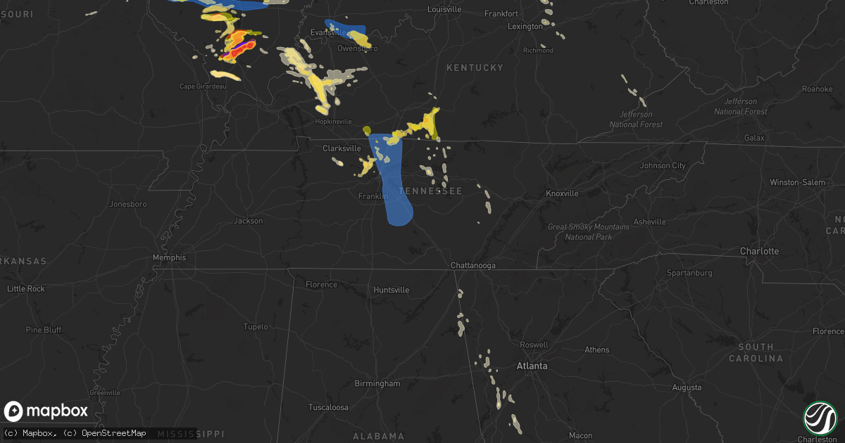
Hail Map in Tennessee on June 30, 2023
Get this storm
June 30 map
$229
one time, instant access
Download today. No call, no setup
Keep the $229
Bought the map and want the full workflow? Apply the entire $229 to a subscription within 7 days. None of it is wasted.
Every map, not just this one
This buys you this map. Subscription and you get every map we run, in the markets you choose from a few cities to whole states to nationwide. Plus real-time alerts the moment a storm fires.
Contact data
Name, contact info, occupancy, even credit band for addresses in the footprint. You go from where it hit to who to call.
Become the source they trust
Unlimited branding weather history reports on demand. You already have the documented answer ready for the property owner, and you are the one who showed up with it.
Property data and RoofTrace estimates
Pull up any address you have got, its value and the exact code rules for that jurisdiction, straight from One Click Code. Then RoofTrace estimates the squares, pitch, and roof value, priced the way you price.
Storm reports in Tennessee
Tennessee
| Date | Description |
|---|---|
| 06/30/20236:52 PM CDT | Tree on house... Power outages across the county. |
| 06/30/20236:52 PM CDT | Corrects previous tstm wnd dmg report from red boiling spring. Tree on house near lafayette road and east main street. Power outages across the county. |
| 06/29/20239:20 PM CDT | Corrects previous tstm wnd dmg report from 3 ssw franklin. Large limb punched hole through roof of home along heathersett drive. |
| 06/29/20239:20 PM CDT | Corrects previous tstm wnd dmg report from 3 ssw franklin. Large limb punched hole through roof of home. |
| 06/29/20239:10 PM CDT | Trees down across county... Power lines down. Likely caused by outflow well ahead of storms. |
| 06/29/20239:01 PM CDT | Corrects previous tstm wnd dmg report from 2 nne spring hill. Multiple trees down in the spring hill area. Time estimated on radar. |
| 06/29/20239:01 PM CDT | Multiple trees down. Time estimated on radar. |
| 06/29/20239:00 PM CDT | Corrects previous tstm wnd dmg report from 3 sw antioch. A couple trees down in lenox village. |
| 06/29/20238:59 PM CDT | Large tree limb broken. Time estimated on radar. |
| 06/29/20238:55 PM CDT | Corrects previous tstm wnd dmg report from 4 e brentwood. Large tree down blocking road. Time estimated on radar. |
| 06/29/20238:53 PM CDT | Corrects previous tstm wnd dmg report from 4 ese brentwood. Multiple trees and power lines down near concord road and sunset road. |
| 06/29/20238:53 PM CDT | Multiple trees and power lines down. |
| 06/29/20238:52 PM CDT | A couple trees down in lenox village. |
| 06/29/20238:45 PM CDT | Large limb punched hole through roof of home. |
| 06/29/20238:45 PM CDT | Corrects previous tstm wnd dmg report from 1 wnw smyrna. Tree down blocking road. Time estimated on radar. |
| 06/29/20238:45 PM CDT | Corrects previous tstm wnd dmg report from 1 wnw smyrna. Tree down blocking rock springs road near mason tucker drive. Time estimated on radar. |
| 06/29/20238:43 PM CDT | Tree fell on car. Time estimated on radar. |
| 06/29/20238:43 PM CDT | Corrects previous tstm wnd dmg report from 3 ne antioch. Tree fell on car near long hunter lane and nashboro boulevard. Time estimated on radar. |
| 06/29/20238:40 PM CDT | Corrects previous tstm wnd dmg report from 2 sse belinda city. Two power poles snapped near central pike and lohman road. About 8200 power outages across wilson county. |
| 06/29/20238:40 PM CDT | Corrects previous tstm wnd dmg report from 2 sse belinda city. Two power poles snapped in this area. About 8200 power outages across wilson county. |
| 06/29/20238:34 PM CDT | A local report indicates 60 MPH wind near 2 S Mount Juliet |
| 06/29/20238:28 PM CDT | Large tree down blocking the road. Time estimated on radar. |
| 06/29/20238:28 PM CDT | Corrects previous tstm wnd dmg report from 3 w nashville. Large tree down blocking dr walter s davis road. Time estimated on radar. |
| 06/29/20238:27 PM CDT | Two power poles snapped in this area. About 8200 power outages across wilson county. |
| 06/29/20238:20 PM CDT | Large tree down. |
| 06/29/20238:20 PM CDT | Corrects previous tstm wnd dmg report from 1 nnw hendersonville. Large tree down near east main street and park road. |
| 06/29/20238:16 PM CDT | Tree down blocking road. Time estimated on radar. |
| 06/29/20238:09 PM CDT | Large tree down blocking road. Time estimated on radar. |
| 06/29/20237:58 PM CDT | Corrects previous tstm wnd dmg report from 2 w orlinda. Multiple trees and power lines down near highway 49 e and east church street. Widespread power outages across ro |
| 06/29/20237:58 PM CDT | Multiple trees and power lines down. Widespread power outages across robertson county. |
| 06/29/20237:58 PM CDT | Several trees down on hwy 31 between gallatin and westmoreland. |
| 06/29/20237:45 PM CDT | Corrects previous tstm wnd dmg report from 6 ssw bethpage. Multiple trees down across brights lane. Time estimated on radar. |
| 06/29/20237:44 PM CDT | Corrects previous tstm wnd dmg report from 6 ne cedar hill. Tree on house near highway 161 and corbin sneed road. Power lines down across the county. |
| 06/29/20237:44 PM CDT | Tree on house... Power lines down across the county. |
| 06/29/20237:16 PM CDT | Multiple trees down across road. Time estimated on radar. |
All States Impacted by Hail Map on June 30, 2023
Cities Impacted by Hail Map on June 30, 2023
- Parnell, MO
- Blockton, IA
- Redding, IA
- Bedford, IA
- Benton, IA
- Sheridan, MO
- Lamoni, IA
- Eagleville, MO
- Davis City, IA
- Hatfield, MO
- Blythedale, MO
- Mercer, MO
- Kellerton, IA
- Cainsville, MO
- Mount Ayr, IA
- Grant City, MO
- Clio, IA
- Garden Grove, IA
- Decatur, IA
- Leon, IA
- Allerton, IA
- Grand River, IA
- Lineville, IA
- Corydon, IA
- Humeston, IA
- Seymour, IA
- Unionville, MO
- Powersville, MO
- Princeton, MO
- Sault Sainte Marie, MI
- Monterey, TN
- Crossville, TN
- Pattonsburg, MO
- Green Castle, MO
- Green City, MO
- Ridgeway, MO
- Gilman City, MO
- Gaylesville, AL
- Kahoka, MO
- Luray, MO
- Sedalia, CO
- Cedar Bluff, AL
- Hamilton, IL
- Basco, IL
- Elvaston, IL
- Warsaw, IL
- Keokuk, IA
- Carthage, IL
- Montrose, IA
- Pikeville, TN
- Argyle, IA
- Wayland, MO
- Newtown, MO
- Menlo, GA
- Brimley, MI
- Lucerne, MO
- Harris, MO
- Bethany, MO
- Plymouth, IL
- Farmington, IA
- Alexandria, MO
- Barbeau, MI
- Dafter, MI
- Kinross, MI
- Rising Fawn, GA
- Livonia, MO
- Queen City, MO
- Glenwood, MO
- Lancaster, MO
- Coatsville, MO
- McFall, MO
- Downing, MO
- Cincinnati, IA
- Arbela, MO
- Tennessee, IL
- Saint Patrick, MO
- Revere, MO
- Nauvoo, IL
- Memphis, MO
- Bloomfield, IA
- Exline, IA
- Centerville, IA
- Moulton, IA
- Pollock, MO
- Rockmart, GA
- Cantril, IA
- Mount Sterling, IA
- Eckerman, MI
- Hill City, SD
- Arriba, CO
- Flagler, CO
- Colorado Springs, CO
- Fountain, CO
- Seibert, CO
- Cope, CO
- Trinidad, CO
- Joes, CO
- Vona, CO
- Bethune, CO
- Stratton, CO
- Burlington, CO
- Rye, CO
- Pueblo, CO
- Strasburg, CO
- Idalia, CO
- Avondale, CO
- Saint Francis, KS
- Kanorado, KS
- Goodland, KS
- Levelland, TX
- Branson, CO
- Edson, KS
- Sturgis, KY
- Kim, CO
- Carbondale, IL
- Makanda, IL
- Brewster, KS
- Bird City, KS
- McDonald, KS
- Levant, KS
- Colby, KS
- Atwood, KS
- Carterville, IL
- Marion, IL
- Fort Stockton, TX
- Imperial, TX
- Mokane, MO
- Steedman, MO
- Chamois, MO
- Morrison, MO
- Hermann, MO
- Anton, TX
- Clarendon, TX
- Mclean, TX
- Shamrock, TX
- Energy, IL
- Herrin, IL
- Gem, KS
- Rexford, KS
- Johnston City, IL
- Glasgow, KY
- Cobden, IL
- Jonesboro, IL
- Anna, IL
- Dongola, IL
- Buncombe, IL
- Wakefield, KS
- Chapman, KS
- Junction City, KS
- Pacific, MO
- Hoxie, KS
- Selden, KS
- Pittsburg, IL
- Thompsonville, IL
- Milford, KS
- Kinsley, KS
- West Frankfort, IL
- Scobey, MT
- Bellvue, CO
- Boone, CO
- Union, MS
- Philadelphia, MS
- Aguilar, CO
- Halliday, ND
- Taylor, ND
- Gladstone, ND
- Brockton, MT
- Edgemont, SD
- Goreville, IL
- Smiths Grove, KY
- Froid, MT
- Kosciusko, MS
- Ethel, MS
- Madisonville, KY
- Nebo, KY
- Providence, KY
- Manitou, KY
- Wedowee, AL
- Wadley, AL
- Whitesburg, GA
- Carrollton, GA
- Centre, AL
- Dickinson, ND
- Manning, ND
- Littlefield, TX
- Millport, AL
- Whitetail, MT
- Tebbetts, MO
- Kermit, TX
- Wink, TX
- Hawks, MI
- Hillman, MI
- Lachine, MI
- Posen, MI
- Pritchett, CO
- Las Animas, CO
- Springfield, CO
- Labadie, MO
- Saint Albans, MO
- Villa Rica, GA
- Manchester, GA
- Temple, GA
- Bremen, GA
- Grantville, GA
- Hogansville, GA
- Lefor, ND
- Claude, TX
- Jennings, KS
- Oberlin, KS
- Dresden, KS
- Murphysboro, IL
- Uniontown, KY
- Jacksonville, AL
- Piedmont, AL
- Pine Ridge, SD
- Imperial, MO
- Greenville, GA
- Woodbury, GA
- Ozark, IL
- Creal Springs, IL
- Monahans, TX
- Marion, KY
- Panhandle, TX
- Warm Springs, GA
- Golden, CO
- Petersburg, TX
- Clay Center, KS
- Riley, KS
- Leonardville, KS
- Arnold, MO
- House Springs, MO
- Reserve, MT
- Newnan, GA
- Red Feather Lakes, CO
- Mott, ND
- Lewiston, MI
- Comins, MI
- Maxwell, NM
- Waverly, KY
- Morganfield, KY
- Clay, KY
- Barstow, TX
- Turner, MT
- Hugo, CO
- Bowling Green, VA
- Oglala, SD
- Lamar, CO
- Idalou, TX
- Anniston, AL
- Cedartown, GA
- Buchanan, GA
- Senoia, GA
- Moreland, GA
- Sharpsburg, GA
- Roanoke, AL
- Woodland, AL
- Muscadine, AL
- Fruithurst, AL
- Tallapoosa, GA
- Abilene, KS
- Columbus, MS
- Hamilton, MS
- Hogeland, MT
- Model, CO
- Hay Springs, NE
- Lorenzo, TX
- Princeton, KY
- Lagrange, GA
- Franklin, GA
- Meadow, TX
- Mount Vernon, IN
- Carthage, MS
- Estes Park, CO
- Alexander City, AL
- Jacksons Gap, AL
- Cave In Rock, IL
- Boncarbo, CO
- Amarillo, TX
- Canyon, TX
- Sulligent, AL
- Weston, CO
- Elizabethtown, IL
- Wolf Lake, IL
- Gardner, CO
- Happy, TX
- Coyanosa, TX
- Dadeville, AL
- Camp Hill, AL
- Caledonia, MS
- Wetmore, CO
- Saint Louis, MO
- Steens, MS
- Columbia, IL
- East Carondelet, IL
- Dupo, IL
- Vienna, IL
- Cypress, IL
- Dawson Springs, KY
- Manhattan, KS
- Eureka, MO
- Ballwin, MO
- Fenton, MO
- Valley Park, MO
- High Ridge, MO
- Lucas, KY
- Scottsville, KY
- Fountain Run, KY
- Austin, KY
- Etoile, KY
- Tompkinsville, KY
- Gamaliel, KY
- Morland, KS
- Penokee, KS
- Hill City, KS
- Wildwood, MO
- Waterloo, IL
- Valmeyer, IL
- Millstadt, IL
- Belleville, IL
- Smithton, IL
- Bogue, KS
- Stockton, KS
- Palco, KS
- Damar, KS
- Plainville, KS
- Kearney, MO
- Holt, MO
- Lawson, MO
- Alma, KS
- Kirwin, KS
- Glade, KS
- Saint Charles, KY
- Cerulean, KY
- Olmstead, KY
- Russellville, KY
- Freeburg, IL
- New Athens, IL
- Mascoutah, IL
- Tamaroa, IL
- Sesser, IL
- Lathrop, MO
- Polo, MO
- Excelsior Springs, MO
- Orrick, MO
- Richmond, MO
- Montgomery City, MO
- Wellsville, MO
- Middletown, MO
- Bellflower, MO
- Paxico, KS
- McFarland, KS
- Wamego, KS
- Maple Hill, KS
- De Soto, IL
- Freeman Spur, IL
- Woodston, KS
- Natoma, KS
- Alton, KS
- Osborne, KS
- Waldo, KS
- Royalton, IL
- Mulkeytown, IL
- Elkville, IL
- Zeigler, IL
- Orient, IL
- Christopher, IL
- Buckner, IL
- Benton, IL
- Adairville, KY
- Logan, IL
- Scheller, IL
- Waltonville, IL
- Turney, MO
- Topeka, KS
- Cameron, MO
- Kingston, MO
- Hardin, MO
- Henrietta, MO
- Lexington, MO
- Marissa, IL
- Lenzburg, IL
- Saint Libory, IL
- Addieville, IL
- Okawville, IL
- Oakdale, IL
- Nashville, IL
- Richview, IL
- Hoyleton, IL
- New Baden, IL
- Franklin, KY
- Harveyville, KS
- Macedonia, IL
- Dover, MO
- Norborne, MO
- Ralls, TX
- Crosbyton, TX
- Dickens, TX
- Spur, TX
- Rossville, KS
- Silver Lake, KS
- Hawk Point, MO
- Truxton, MO
- Silex, MO
- Du Bois, IL
- Ashley, IL
- Mount Vernon, IL
- Woodlawn, IL
- Opdyke, IL
- Lecompton, KS
- Grantville, KS
- Tecumseh, KS
- Meriden, KS
- Perry, KS
- Paradise, KS
- Coulterville, IL
- Pinckneyville, IL
- Ozawkie, KS
- Springfield, TN
- Orlinda, TN
- White House, TN
- Cross Plains, TN
- Cottontown, TN
- Gallatin, TN
- Hendersonville, TN
- Goodlettsville, TN
- Greenbrier, TN
- Whites Creek, TN
- Madison, TN
- Nashville, TN
- Old Hickory, TN
- Hermitage, TN
- Antioch, TN
- Smyrna, TN
- La Vergne, TN
- Mount Juliet, TN
- Lebanon, TN
- Nolensville, TN
- Portland, TN
- Tipton, KS
- Downs, KS
- Hunter, KS
- Troy, IL
- Oskaloosa, KS
- Nortonville, KS
- Valley Falls, KS
- Winchester, KS
- McLouth, KS
- Saint Jacob, IL
- Atchison, KS
- Tonganoxie, KS
- Easton, KS
- Leavenworth, KS
- Fort Leavenworth, KS
- Platte City, MO
- Weston, MO
- Cummings, KS
- Rushville, MO
- Readyville, TN
- Murfreesboro, TN
- Christiana, TN
- Arrington, TN
- Rockvale, TN
- College Grove, TN
- Eagleville, TN
- Franklin, TN
- Brentwood, TN
- Wayne City, IL
- Sims, IL
- Bluford, IL
- Belle Rive, IL
- Keenes, IL
- Dahlgren, IL
- Saint Ann, MO
- Lawrence, KS
- Lansing, KS
- Basehor, KS
- Gail, TX
- Fluvanna, TX
- Snyder, TX
- Ira, TX
- Hermleigh, TX
- Sweetwater, TX
- Loraine, TX
- Roscoe, TX
- Dearborn, MO
- De Kalb, MO
- Saint Joseph, MO
- Troy, KS
- Wathena, KS
- Faucett, MO
- Kansas City, KS
- Farley, MO
- Camden Point, MO
- Unionville, TN
- Bell Buckle, TN
- Chapel Hill, TN
- Shelbyville, TN
- Wartrace, TN
- Easton, MO
- Elwood, KS
- Agency, MO
- Clayton, NM
- Gladstone, NM
- Roy, NM
- Springer, NM
- Savannah, MO
- Amazonia, MO
- Cosby, MO
- Stewartsville, MO
- Gower, MO
- Clarksdale, MO
- Union Star, MO
- Helena, MO
- Liberty, MO
- Blackwater, MO
- Nelson, MO
- Pilot Grove, MO
- Mattoon, IL
- Franklin, MO
- New Franklin, MO
- Rea, MO
- Barnard, MO
- Bolckow, MO
- Conception Junction, MO
- Maryville, MO
- Guilford, MO
- Osborn, MO
- King City, MO
- Weatherby, MO
- Amity, MO
- Winston, MO
- Maysville, MO
- Altamont, MO
- Plattsburg, MO
- Gallatin, MO
- Kidder, MO
- Hamilton, MO
- Edgerton, MO
- Amistad, NM
- Waldron, IN
- Shelbyville, IN
- Hartsville, IN
- Hope, IN
- Greensburg, IN
- Lock Springs, MO
- Jamesport, MO
- Jameson, MO
- Braymer, MO
- Breckenridge, MO
- Chillicothe, MO
- Mooresville, MO
- Cowgill, MO
- Ludlow, MO
- Boonville, MO
- Trenton, MO
- Dawn, MO
- Utica, MO
- Nara Visa, NM
- Dalhart, TX
- Carson, ND
- Ellsworth, KS
- Merriman, NE
- Vandalia, MO
- Murdo, SD
- Elgin, ND
- Wentzville, MO
- Lake Saint Louis, MO
- Wood, SD
- Richardton, ND
- Crofton, KY
- Lena, MS
- Watford City, ND
- Holland, KY
- Killdeer, ND
- Collinsville, IL
- Glen Carbon, IL
- Granite City, IL
- Maryville, IL
- Morton, MS
- Pulaski, MS
- Rocheport, MO
- Columbia, MO
- Braxton, MS
- Florence, MS
- Camden, MO
- Indianapolis, IN
- Port Austin, MI
- Frohna, MO
- Smithville, TN
- Edwardsville, IL
- Marine, IL
- Floydada, TX
- Dodson, MT
- Troy, MO
- East Saint Louis, IL
- Vergennes, IL
- Eddyville, NE
- Sumner, NE
- Keene, ND
- Eskridge, KS
- Coatesville, IN
- Conehatta, MS
- Lawrence, MS
- Cambria, IL
- Clayton, KS
- Lenora, KS
- Norton, KS
- Almena, KS
- Norcatur, KS
- Brownell, KS
- Ellis, KS
- Post, TX
- Martinsburg, MO
- Warrenton, MO
- Maryland Heights, MO
- Seminole, TX
- Saint George, KS
- Welch, TX
- Boise City, OK
- Ashland City, TN
- White Bluff, TN
- Menoken, ND
- Sylvan Grove, KS
- Wilson, KS
- Lorraine, KS
- Kanopolis, KS
- Holyrood, KS
- Dorrance, KS
- Bunker Hill, KS
- Brownfield, TX
- Cave City, KY
- Horse Cave, KY
- Pleasant View, TN
- Ava, IL
- Gorham, IL
- Shawneetown, IL
- Junction, IL
- Arcadia, NE
- Andrews, TX
- Overton, NE
- Bazine, KS
- Ness City, KS
- Hope, KS
- Victoria, KS
- La Crosse, KS
- Bison, KS
- Hays, KS
- Nekoma, KS
- Pocahontas, IL
- Hickman, TN
- Liberty, TN
- Alexandria, TN
- Independence, MO
- Brush Creek, TN
- Carthage, TN
- Gordonsville, TN
- Riddleton, TN
- Goodwell, OK
- Walnut Grove, MS
- Fairfield, IL
- Golden Gate, IL
- Wellington, TX
- Saint Marys, KS
- Francisco, IN
- Petersburg, IN
- Charleston, IL
- Ashmore, IL
- Enterprise, KS
- Augusta, MO
- Defiance, MO
- Marthasville, MO
- Lafayette, TN
- Pelahatchie, MS
- Brandon, MS
- Whitleyville, TN
- Red Boiling Springs, TN
- Canute, OK
- Galatia, IL
- Carrier Mills, IL
- Pittsboro, NC
- Olsburg, KS
- Chesterfield, MO
- Saint Charles, MO
- Ina, IL
- Bonnie, IL
- Cunningham, TN
- Cumberland Furnace, TN
- Rayville, MO
- Chapmansboro, TN
- Denver City, TX
- Milford, VA
- Joelton, TN
- Carter, OK
- Granville, TN
- Buffalo Valley, TN
- Bloomington Springs, TN
- Curryville, MO
- Bowling Green, MO
- Pleasant Shade, TN
- Dixon Springs, TN
- Raleigh, IL
- Eldorado, IL
- Broughton, IL
- Highland, IL
- Slaughters, KY
- Hanson, KY
- Raleigh, MS
- Silver Point, TN
- Philpot, KY
- Johnsonville, IL
- Guymon, OK
- Albion, IL
- Du Quoin, IL
- Ridgway, IL
- Omaha, IL
- Baxter, TN
- Gracey, KY
- Caneyville, KY
- Brownsville, KY
- Leitchfield, KY
- Tahoka, TX
- Oakley, KS
- Barnes, KS
- Waterville, KS
- Randolph, KS
- Green, KS
- Offerle, KS
- Forest, MS
- Lake, MS
- Pomona, IL
- Plains, TX
- Larkspur, CO
- Elbert, CO
- Pegram, TN
- Rush Center, KS
- Liebenthal, KS
- McCracken, KS
- Walker, KS
- Gorham, KS
- Otis, KS
- Schoenchen, KS
- Russell, KS
- Pfeifer, KS
- Alta Vista, KS
- Dwight, KS
- Grand Tower, IL
- Alvaton, KY
- Adolphus, KY
- Chapel Hill, NC
- Moncure, NC
- New Bloomfield, MO
- Mendenhall, MS
- Trenton, IL
- Southside, TN
- Hurst, IL
- Palmyra, TN
- Winner, SD
- Crawfordsville, IN
- Campo, CO
- Kenton, OK
- Sheridan Lake, CO
- Ropesville, TX
- Beulah, ND
- Paris, IL
- Kansas, IL
- Gypsum, KS
- Hopkinsville, KY
- Equality, IL
- Earlington, KY
- Nortonville, KY
- Lucas, KS
- Beloit, KS
- Ransom, KS
- Wakeeney, KS
- Portis, KS
- Keyes, OK
- Florissant, CO
- Cripple Creek, CO
- White River, SD
- Harrisburg, IL
- Greenwood, IN
- Dixon, KY
- Guffey, CO
- Granada, CO
- Kingston Springs, TN
- Park City, KY
- Bowling Green, KY
- Allensville, KY
- Cedar Hill, TN
- Charlotte, TN
- Westmoreland, TN
- Gainesboro, TN
- Washington, MO
- Roxie, MS
- Lovejoy, IL
- Venice, IL
- Madison, IL
- Gray Summit, MO
- Caseyville, IL
- Dowell, IL
- Lebanon, IL
- O'Fallon, IL
- Foristell, MO
- Tribune, KS
- Fillmore, IN
- Greencastle, IN
- Justiceburg, TX
- Belvue, KS
- Rinard, IL
- Westport, IN
- North Vernon, IN
- Versailles, IN
- Cross Plains, IN
- Dillsboro, IN
- Bennington, IN
- Stratford, TX
- West Terre Haute, IN
- Vermilion, IL
- Clinton, IN
- Universal, IN
- Rosedale, IN
- New Goshen, IN
- Terre Haute, IN
- Laredo, MO
- Chula, MO
- Humphreys, MO
- Wheeling, MO
- Meadville, MO
- Rising Sun, IN
- Patriot, IN
- Vevay, IN
- Florence, IN
- Staunton, IN
- Knightsville, IN
- Harmony, IN
- Brazil, IN
- Centerpoint, IN
- Reelsville, IN
- Poland, IN
- Cloverdale, IN
- Spencer, IN
- Glencoe, KY
- Sparta, KY
- Warsaw, KY
- Quincy, IN
- Gosport, IN
- Dry Ridge, KY
- Jonesville, KY
- Centralia, IL
- Alma, IL
- Annapolis, IL
- Bartelso, IL
- Newton, IL
- Carlyle, IL
- Louisville, IL
- Oblong, IL
- West York, IL
- Hutsonville, IL
- Farina, IL
- Hoffman, IL
- Salem, IL
- Willow Hill, IL
- Kinmundy, IL
- Dieterich, IL
- Odin, IL
- Sandoval, IL
- Xenia, IL
- Evansville, IN
- Chandler, IN
- Boonville, IN
- Elberfeld, IN
- Newburgh, IN
- Chrisney, IN
- Tennyson, IN
- Richland, IN
- Rockport, IN
- Grandview, IN
- Masterson, TX
- Vega, TX
- Sabetha, KS
- Oneida, KS
- Louisiana, MO
- Pleasant Hill, IL
- Shelbina, MO
- Shelbyville, MO
- Valley Head, AL
- Osgood, IN
- Girard, IL
- Salisbury, MO
- Raymond, IL
- Winchester, KY
- Paris, KY
- Slater, MO
- Corinth, KY
- Cynthiana, KY
- Williamstown, KY
- Carlisle, KY
- Berry, KY
- Windsor, IL
- Milan, IN
- Scottsburg, IN
- Deputy, IN
- Austin, IN
- Hull, IL
- Hannibal, MO
- Virden, IL
- Texline, TX
- Tina, MO
- Hale, MO
- Breese, IL
- Bainbridge, IN
- Bogard, MO
- Rockport, IL
- Bowling Green, IN
- Cairo, MO
- Jacksonville, MO
- Carbon, IN
- Ethel, MO
- New Boston, MO
- Madison, IN
- Owenton, KY
- Maceo, KY
- Owensboro, KY
- New Florence, MO
- Waverly, IL
- Mount Sterling, KY
- Bremen, KY
- Fayette, MO
- Pittsfield, IL
- Harvel, IL
- Mosquero, NM
- Monroe City, MO
- Lancaster, KS
- Murrayville, IL
- Roodhouse, IL
- Westfield, IL
- Lynnville, IN
- Keytesville, MO
- Lyerly, GA
- Nebo, IL
- Robinson, IL
- Lewisport, KY
- Sacramento, KY
- Island, KY
- Geff, IL
- Cisne, IL
- Palmyra, IL
- Holton, IN
- Butlerville, IN
- Flat Rock, IN
- Edinburgh, IN
- Central City, KY
- Mendon, MO
- Marceline, MO
- Lebanon, IN
- Jamestown, IN
- Pearl, IL
- Hillview, IL
- Canaan, IN
- Moores Hill, IN
- Aurora, IN
- Freetown, IN
- Franklin, IL
- Greensburg, KS
- Stilesville, IN
- Clayton, IN
- Winchester, IL
- Trilla, IL
- Neoga, IL
- Bargersville, IN
- Franklin, IN
- Auburn, IL
- Excello, MO
- Macon, MO
- Bevier, MO
- Richmond, KY
- Beech Grove, IN
- Bloomington, IN
- Marshall, MO
- Hughesville, MO
- Rockville, IN
- Mortons Gap, KY
- Calhoun, KY
- Rumsey, KY
- Milroy, IN
- Saint Paul, IN
- Henderson, KY
- Stamping Ground, KY
- Frankfort, KY
- Reynolds Station, KY
- Palmyra, MO
- Huntsville, MO
- Dalton City, IL
- Milton, KY
- Poseyville, IN
- Bedford, KY
- Pendleton, KY
- Needham, IN
- Whiteland, IN
- Boggstown, IN
- Ghent, KY
- Martinsville, IN
- Mooresville, IN
- Fairland, IN
- Meredosia, IL
- Chapin, IL
- Arenzville, IL
- Hanover, IN
- Nabb, IN
- Mullinville, KS
- White Hall, IL
- Greenfield, IL
- Carrollton, IL
- Marshall, IL
- Lerna, IL
- Toledo, IL
- Greenup, IL
- Morrisonville, IL
- Farmersville, IL
- Pawnee, IL
- Concord, IL
- Bendena, KS
- Kell, IL
- Iuka, IL
- Nashville, IN
- Livermore, KY
- Hartford, KY
- Columbus, IN
- Lexington, IN
- Bucklin, MO
- Nokomis, IL
- Rotan, TX
- Quincy, IL
- Taylor, MO
- Avon, IN
- Shipman, IL
- Virginia, IL
- Ellery, IL
- Hollywood, AL
- Dennison, IL
- Timewell, IL
- Hunnewell, MO
- Linn, MO
- Fort Branch, IN
- Haubstadt, IN
- Browns, IL
- Griffin, IN
- Wadesville, IN
- Owensville, IN
- Cynthiana, IN
- Hawesville, KY
- New Harmony, IN
- Fordsville, KY
- Grayville, IL
- Sadieville, KY
- La Monte, MO
- Houstonia, MO
- Paris, MO
- Camp Point, IL
- Rhineland, MO
- Waggoner, IL
- Emden, MO
- Philadelphia, MO
- Fort Riley, KS
- Callao, MO
- Palmer, IL
- Taylorville, IL
- Commiskey, IN
- Wrights, IL
- Seymour, IN
- Palestine, IL
- Carrollton, MO
- Putnamville, IN
- Clarence, MO
- Longford, KS
- Minneapolis, KS
- Payson, IL
- Strasburg, IL
- Gays, IL
- Carlinville, IL
- Brookfield, MO
- Rothville, MO
- New Cambria, MO
- Dalton, MO
- Casey, IL
- Verona, KY
- Summerfield, IL
- Alhambra, IL
- Beckemeyer, IL
- Aviston, IL
- Germantown, IL
- Fairview Heights, IL
- New Douglas, IL
- Modesto, IL
- Union, MO
- Clayton, IL
- Gillespie, IL
- Beardstown, IL
- Bonnots Mill, MO
- Brusett, MT
- West Salem, IL
- Le Roy, IL
- Linton, IN
- Lyons, IN
- Sandborn, IN
- Lentner, MO
- Anabel, MO
- Madison, MO
- Cuba, MO
- Sullivan, MO
- Bourbon, MO
- Maywood, MO
- Edina, MO
- Bethany, IL
- Moweaqua, IL
- Flat Rock, IL
- Carlisle, IN
- Merom, IN
- Sullivan, IN
- Waynesville, IL
- Beason, IL
- Atlanta, IL
- Clinton, IL
- Eolia, MO
- Pekin, IN
- Portland, MO
- West Union, IL
- Martinsville, IL
- Bunker Hill, IL
- Irvine, KY
- Jenkins, KY
- Pound, VA
- Wise, VA
- Mayking, KY
- Whitesburg, KY
- Holts Summit, MO
- Versailles, IL
- Ashland, MO
- Hartsburg, MO
- Sigel, IL
- Effingham, IL
- Williamsburg, MO
- Salem, IN
- Teutopolis, IL
- High Hill, MO
- Jonesburg, MO
- Bethalto, IL
- Alton, IL
- Borden, IN
- Berger, MO
- Arthur, IL
- Sullivan, IL
- Brownstown, IN
- Montrose, IL
- Stoy, IL
- Mount Erie, IL
- Cedar Hill, MO
- Fulton, MO
- Jefferson City, MO
- Mitchell, IN
- Shoals, IN
- East Alton, IL
- Wood River, IL
- Nineveh, IN
- Wheeler, IL
- Moro, IL
- Oaktown, IN
- Novelty, MO
- Jeffersonville, KY
- Butler, IL
- Litchfield, IL
- Old Monroe, MO
- Moscow Mills, MO
- O'Fallon, MO
- Rosebud, MO
- Bridgeton, MO
- Saint Peters, MO
- Florissant, MO
- Hazelwood, MO
- Hettick, IL
- Wright City, MO
- Truesdale, MO
- Hurdland, MO
- Decatur, MS
- Garner, KY
- Leburn, KY
- Hindman, KY
- Mousie, KY
- Lovington, IL
- Noble, IL
- Beaufort, MO
- Leslie, MO
- Dittmer, MO
- Griggsville, IL
- Centertown, MO
- Owensville, MO
- Gerald, MO
- New Salem, IL
- New Haven, MO
- Clay City, KY
- Stanton, KY
- Mallie, KY
- Thornton, KY
- Ermine, KY
- Pine Top, KY
- Millstone, KY
- Deane, KY
- Villa Ridge, MO
- Findlay, IL
- Edwardsport, IN
- Westphalia, IN
- Flora, IL


