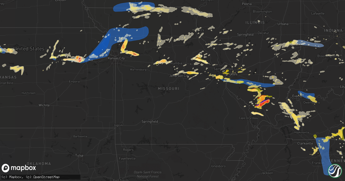
Hail Map in Missouri on June 30, 2023
Get this storm
June 30 map
$229
one time, instant access
Download today. No call, no setup
Keep the $229
Bought the map and want the full workflow? Apply the entire $229 to a subscription within 7 days. None of it is wasted.
Every map, not just this one
This buys you this map. Subscription and you get every map we run, in the markets you choose from a few cities to whole states to nationwide. Plus real-time alerts the moment a storm fires.
Contact data
Name, contact info, occupancy, even credit band for addresses in the footprint. You go from where it hit to who to call.
Become the source they trust
Unlimited branding weather history reports on demand. You already have the documented answer ready for the property owner, and you are the one who showed up with it.
Property data and RoofTrace estimates
Pull up any address you have got, its value and the exact code rules for that jurisdiction, straight from One Click Code. Then RoofTrace estimates the squares, pitch, and roof value, priced the way you price.
Storm reports in Missouri
Missouri
| Date | Description |
|---|---|
| 06/30/20236:58 PM CDT | A local report indicates 1.00 inch wind near 1 ENE Kearney |
| 06/30/20236:56 PM CDT | Report from mping: quarter |
| 06/30/20236:55 PM CDT | Report from mping: trees uprooted or snapped; roof blown off. Time estimated from radar. |
| 06/30/20236:52 PM CDT | 3 limbs down and flagpole bent over. |
| 06/30/20236:50 PM CDT | 12-inch diameter trees limbs were thrown 40 ft. |
| 06/30/20236:45 PM CDT | An eighteen-wheeler fell on its side in the walmart parking lot in arnold... Missouri... Next to a heavily damaged fireworks tent. |
| 06/30/20236:41 PM CDT | Numerous tree branches up to 4 inches in diameter littered the ground. |
| 06/30/20236:39 PM CDT | Corrects previous tstm wnd dmg report from 1 ne oakville. 3 limbs down and flagpole bent over. |
| 06/30/20236:39 PM CDT | Corrects previous tstm wnd dmg report from 1 ene oakville. Report from mping: trees uprooted or snapped; roof blown off. Time estimated from radar. |
| 06/30/20236:29 PM CDT | Report from mping: quarter |
| 06/30/20236:28 PM CDT | 5 trees the size of power poles blown down in high ridge... Mo. |
| 06/30/20236:16 PM CDT | Large tree blow over. |
| 06/30/20236:12 PM CDT | Report from mping: golf ball |
| 06/30/20236:10 PM CDT | A local report indicates 1.00 inch wind near 1 ENE Eureka |
| 06/30/20236:08 PM CDT | A local report indicates 1.00 inch wind near 1 E Eureka |
| 06/30/20236:06 PM CDT | Half dollar size and larger hail in eureka... Legends area. |
| 06/30/20236:05 PM CDT | A local report indicates 1.50 inch wind near 2 NNE Eureka |
| 06/30/20236:02 PM CDT | At the intersection of telegraph road and cliff cave road. |
| 06/30/20236:01 PM CDT | A local report indicates 1.00 inch wind near 1 ESE Mehlville |
| 06/30/20236:00 PM CDT | A local report indicates 1.75 inch wind near 1 ESE Wildwood |
| 06/30/20235:50 PM CDT | A local report indicates 1.00 inch wind near 1 NNE Oakville |
| 06/30/20235:32 PM CDT | A local report indicates 1.50 inch wind near Gasconade |
| 06/30/20235:15 PM CDT | Quarter-sized hail at mark lieneke farm. |
| 06/30/20235:08 PM CDT | Chamois resident observed hail between peas up to ping pong balls. |
| 06/30/20235:06 PM CDT | A local report indicates 2.00 inch wind near Chamois |
| 06/30/20235:03 PM CDT | A local report indicates 1.50 inch wind near 3 SW Chamois |
| 06/30/20234:47 PM CDT | A local report indicates 1.00 inch wind near Mokane |
| 06/30/20237:52 AM CDT | A few tree limbs down. |
| 06/30/20237:40 AM CDT | Large tree branches down throughout town. Power remains out. |
| 06/30/20237:12 AM CDT | A local report indicates 60 MPH wind near 7 N Blythedale |
| 06/30/20231:10 AM CDT | Law enforcement estimated 60 mph wind through kirksville... Which caused a tree limb to come down on a power line. |
| 06/29/202311:42 PM CDT | Tree down in trenton. |
| 06/29/202311:10 PM CDT | Isle of capri casino. |
| 06/29/202310:51 PM CDT | A local report indicates 60 MPH wind near 2 NNE Altamont |
| 06/29/202310:45 PM CDT | Cameron memorial airport. |
| 06/29/202310:44 PM CDT | Tree blocking highway c... 4 miles north of cameron. |
| 06/29/202310:03 PM CDT | A local report indicates 82 MPH wind near 1 NNE Saint Joseph Airp |
| 06/29/202310:03 PM CDT | Delayed report: tree damage shown on social media in the stone crest area of st. Joseph. |
| 06/29/202310:03 PM CDT | Delayed report: tree damage shown on social media |
| 06/29/20239:58 PM CDT | A local report indicates 61 MPH wind near 1 NNE Saint Joseph Airp |
| 06/29/20239:31 PM CDT | Report from mping: quarter |
| 06/29/20239:19 PM CDT | A local report indicates 1.00 inch wind near Cool Valley |
| 06/29/20239:18 PM CDT | A local report indicates 1.00 inch wind near Ferguson |
| 06/29/20239:17 PM CDT | Report from mping: quarter |
| 06/29/20239:16 PM CDT | A local report indicates 1.50 inch wind near Woodson Terrace |
| 06/29/20239:14 PM CDT | A local report indicates 1.00 inch wind near 1 SSW Saint John |
| 06/29/20239:12 PM CDT | A local report indicates 1.00 inch wind near 1 SE Woodson Terrace |
| 06/29/20239:12 PM CDT | A local report indicates 1.00 inch wind near Saint John |
| 06/29/20239:10 PM CDT | Report from mping: quarter |
| 06/29/20239:10 PM CDT | Report from mping: 3-inch tree limbs broken; power poles broken. |
| 06/29/20239:10 PM CDT | Report from mping: qu |
| 06/29/20239:09 PM CDT | Large tree down blocking road. |
| 06/29/20239:04 PM CDT | Multiple trees on roadways. |
| 06/29/20239:01 PM CDT | Large limbs down on roadway. |
| 06/29/20238:10 PM CDT | A local report indicates 1.25 inch wind near 1 ENE Overland |
| 06/29/20238:07 PM CDT | A local report indicates 1.50 inch wind near Hawk Point |
| 06/29/20238:05 PM CDT | A local report indicates 1.25 inch wind near Hawk Point |
| 06/29/20238:01 PM CDT | A local report indicates 1.25 inch wind near 2 WNW Olivette |
| 06/29/20237:53 PM CDT | Lexington middle school. |
| 06/29/20237:52 PM CDT | Delayed report from social media/broadcast media. |
| 06/29/20237:52 PM CDT | Delayed report: social media report with photo attached of larger than 4 inch hail. |
| 06/29/20237:52 PM CDT | A local report indicates 1.00 inch wind near Lexington |
| 06/29/20237:40 PM CDT | Shirkey golf club in richmond. |
| 06/29/20237:39 PM CDT | Caseys general store in richmond. |
| 06/29/20237:30 PM CDT | Trex gas station near lathrop. |
| 06/29/20237:20 PM CDT | A local report indicates 1.50 inch wind near Middletown |
| 06/29/20237:18 PM CDT | A local report indicates 1.50 inch wind near 3 SW Middletown |
| 06/29/20237:18 PM CDT | A local report indicates 1.50 inch wind near 2 SW Middletown |
| 06/29/20237:13 PM CDT | Reported via social media. |
| 06/29/20237:12 PM CDT | 2-3 minutes of golf ball sized hail at this location. Ground covered with smaller hail. |
| 06/29/20237:08 PM CDT | Report via social media. |
| 06/29/20237:04 PM CDT | Report from mping: quarter |
| 06/29/20237:01 PM CDT | Report via social media. |
| 06/29/20237:01 PM CDT | Report via social media. |
All States Impacted by Hail Map on June 30, 2023
Cities Impacted by Hail Map on June 30, 2023
- Parnell, MO
- Blockton, IA
- Redding, IA
- Bedford, IA
- Benton, IA
- Sheridan, MO
- Lamoni, IA
- Eagleville, MO
- Davis City, IA
- Hatfield, MO
- Blythedale, MO
- Mercer, MO
- Kellerton, IA
- Cainsville, MO
- Mount Ayr, IA
- Grant City, MO
- Clio, IA
- Garden Grove, IA
- Decatur, IA
- Leon, IA
- Allerton, IA
- Grand River, IA
- Lineville, IA
- Corydon, IA
- Humeston, IA
- Seymour, IA
- Unionville, MO
- Powersville, MO
- Princeton, MO
- Sault Sainte Marie, MI
- Monterey, TN
- Crossville, TN
- Pattonsburg, MO
- Green Castle, MO
- Green City, MO
- Ridgeway, MO
- Gilman City, MO
- Gaylesville, AL
- Kahoka, MO
- Luray, MO
- Sedalia, CO
- Cedar Bluff, AL
- Hamilton, IL
- Basco, IL
- Elvaston, IL
- Warsaw, IL
- Keokuk, IA
- Carthage, IL
- Montrose, IA
- Pikeville, TN
- Argyle, IA
- Wayland, MO
- Newtown, MO
- Menlo, GA
- Brimley, MI
- Lucerne, MO
- Harris, MO
- Bethany, MO
- Plymouth, IL
- Farmington, IA
- Alexandria, MO
- Barbeau, MI
- Dafter, MI
- Kinross, MI
- Rising Fawn, GA
- Livonia, MO
- Queen City, MO
- Glenwood, MO
- Lancaster, MO
- Coatsville, MO
- McFall, MO
- Downing, MO
- Cincinnati, IA
- Arbela, MO
- Tennessee, IL
- Saint Patrick, MO
- Revere, MO
- Nauvoo, IL
- Memphis, MO
- Bloomfield, IA
- Exline, IA
- Centerville, IA
- Moulton, IA
- Pollock, MO
- Rockmart, GA
- Cantril, IA
- Mount Sterling, IA
- Eckerman, MI
- Hill City, SD
- Arriba, CO
- Flagler, CO
- Colorado Springs, CO
- Fountain, CO
- Seibert, CO
- Cope, CO
- Trinidad, CO
- Joes, CO
- Vona, CO
- Bethune, CO
- Stratton, CO
- Burlington, CO
- Rye, CO
- Pueblo, CO
- Strasburg, CO
- Idalia, CO
- Avondale, CO
- Saint Francis, KS
- Kanorado, KS
- Goodland, KS
- Levelland, TX
- Branson, CO
- Edson, KS
- Sturgis, KY
- Kim, CO
- Carbondale, IL
- Makanda, IL
- Brewster, KS
- Bird City, KS
- McDonald, KS
- Levant, KS
- Colby, KS
- Atwood, KS
- Carterville, IL
- Marion, IL
- Fort Stockton, TX
- Imperial, TX
- Mokane, MO
- Steedman, MO
- Chamois, MO
- Morrison, MO
- Hermann, MO
- Anton, TX
- Clarendon, TX
- Mclean, TX
- Shamrock, TX
- Energy, IL
- Herrin, IL
- Gem, KS
- Rexford, KS
- Johnston City, IL
- Glasgow, KY
- Cobden, IL
- Jonesboro, IL
- Anna, IL
- Dongola, IL
- Buncombe, IL
- Wakefield, KS
- Chapman, KS
- Junction City, KS
- Pacific, MO
- Hoxie, KS
- Selden, KS
- Pittsburg, IL
- Thompsonville, IL
- Milford, KS
- Kinsley, KS
- West Frankfort, IL
- Scobey, MT
- Bellvue, CO
- Boone, CO
- Union, MS
- Philadelphia, MS
- Aguilar, CO
- Halliday, ND
- Taylor, ND
- Gladstone, ND
- Brockton, MT
- Edgemont, SD
- Goreville, IL
- Smiths Grove, KY
- Froid, MT
- Kosciusko, MS
- Ethel, MS
- Madisonville, KY
- Nebo, KY
- Providence, KY
- Manitou, KY
- Wedowee, AL
- Wadley, AL
- Whitesburg, GA
- Carrollton, GA
- Centre, AL
- Dickinson, ND
- Manning, ND
- Littlefield, TX
- Millport, AL
- Whitetail, MT
- Tebbetts, MO
- Kermit, TX
- Wink, TX
- Hawks, MI
- Hillman, MI
- Lachine, MI
- Posen, MI
- Pritchett, CO
- Las Animas, CO
- Springfield, CO
- Labadie, MO
- Saint Albans, MO
- Villa Rica, GA
- Manchester, GA
- Temple, GA
- Bremen, GA
- Grantville, GA
- Hogansville, GA
- Lefor, ND
- Claude, TX
- Jennings, KS
- Oberlin, KS
- Dresden, KS
- Murphysboro, IL
- Uniontown, KY
- Jacksonville, AL
- Piedmont, AL
- Pine Ridge, SD
- Imperial, MO
- Greenville, GA
- Woodbury, GA
- Ozark, IL
- Creal Springs, IL
- Monahans, TX
- Marion, KY
- Panhandle, TX
- Warm Springs, GA
- Golden, CO
- Petersburg, TX
- Clay Center, KS
- Riley, KS
- Leonardville, KS
- Arnold, MO
- House Springs, MO
- Reserve, MT
- Newnan, GA
- Red Feather Lakes, CO
- Mott, ND
- Lewiston, MI
- Comins, MI
- Maxwell, NM
- Waverly, KY
- Morganfield, KY
- Clay, KY
- Barstow, TX
- Turner, MT
- Hugo, CO
- Bowling Green, VA
- Oglala, SD
- Lamar, CO
- Idalou, TX
- Anniston, AL
- Cedartown, GA
- Buchanan, GA
- Senoia, GA
- Moreland, GA
- Sharpsburg, GA
- Roanoke, AL
- Woodland, AL
- Muscadine, AL
- Fruithurst, AL
- Tallapoosa, GA
- Abilene, KS
- Columbus, MS
- Hamilton, MS
- Hogeland, MT
- Model, CO
- Hay Springs, NE
- Lorenzo, TX
- Princeton, KY
- Lagrange, GA
- Franklin, GA
- Meadow, TX
- Mount Vernon, IN
- Carthage, MS
- Estes Park, CO
- Alexander City, AL
- Jacksons Gap, AL
- Cave In Rock, IL
- Boncarbo, CO
- Amarillo, TX
- Canyon, TX
- Sulligent, AL
- Weston, CO
- Elizabethtown, IL
- Wolf Lake, IL
- Gardner, CO
- Happy, TX
- Coyanosa, TX
- Dadeville, AL
- Camp Hill, AL
- Caledonia, MS
- Wetmore, CO
- Saint Louis, MO
- Steens, MS
- Columbia, IL
- East Carondelet, IL
- Dupo, IL
- Vienna, IL
- Cypress, IL
- Dawson Springs, KY
- Manhattan, KS
- Eureka, MO
- Ballwin, MO
- Fenton, MO
- Valley Park, MO
- High Ridge, MO
- Lucas, KY
- Scottsville, KY
- Fountain Run, KY
- Austin, KY
- Etoile, KY
- Tompkinsville, KY
- Gamaliel, KY
- Morland, KS
- Penokee, KS
- Hill City, KS
- Wildwood, MO
- Waterloo, IL
- Valmeyer, IL
- Millstadt, IL
- Belleville, IL
- Smithton, IL
- Bogue, KS
- Stockton, KS
- Palco, KS
- Damar, KS
- Plainville, KS
- Kearney, MO
- Holt, MO
- Lawson, MO
- Alma, KS
- Kirwin, KS
- Glade, KS
- Saint Charles, KY
- Cerulean, KY
- Olmstead, KY
- Russellville, KY
- Freeburg, IL
- New Athens, IL
- Mascoutah, IL
- Tamaroa, IL
- Sesser, IL
- Lathrop, MO
- Polo, MO
- Excelsior Springs, MO
- Orrick, MO
- Richmond, MO
- Montgomery City, MO
- Wellsville, MO
- Middletown, MO
- Bellflower, MO
- Paxico, KS
- McFarland, KS
- Wamego, KS
- Maple Hill, KS
- De Soto, IL
- Freeman Spur, IL
- Woodston, KS
- Natoma, KS
- Alton, KS
- Osborne, KS
- Waldo, KS
- Royalton, IL
- Mulkeytown, IL
- Elkville, IL
- Zeigler, IL
- Orient, IL
- Christopher, IL
- Buckner, IL
- Benton, IL
- Adairville, KY
- Logan, IL
- Scheller, IL
- Waltonville, IL
- Turney, MO
- Topeka, KS
- Cameron, MO
- Kingston, MO
- Hardin, MO
- Henrietta, MO
- Lexington, MO
- Marissa, IL
- Lenzburg, IL
- Saint Libory, IL
- Addieville, IL
- Okawville, IL
- Oakdale, IL
- Nashville, IL
- Richview, IL
- Hoyleton, IL
- New Baden, IL
- Franklin, KY
- Harveyville, KS
- Macedonia, IL
- Dover, MO
- Norborne, MO
- Ralls, TX
- Crosbyton, TX
- Dickens, TX
- Spur, TX
- Rossville, KS
- Silver Lake, KS
- Hawk Point, MO
- Truxton, MO
- Silex, MO
- Du Bois, IL
- Ashley, IL
- Mount Vernon, IL
- Woodlawn, IL
- Opdyke, IL
- Lecompton, KS
- Grantville, KS
- Tecumseh, KS
- Meriden, KS
- Perry, KS
- Paradise, KS
- Coulterville, IL
- Pinckneyville, IL
- Ozawkie, KS
- Springfield, TN
- Orlinda, TN
- White House, TN
- Cross Plains, TN
- Cottontown, TN
- Gallatin, TN
- Hendersonville, TN
- Goodlettsville, TN
- Greenbrier, TN
- Whites Creek, TN
- Madison, TN
- Nashville, TN
- Old Hickory, TN
- Hermitage, TN
- Antioch, TN
- Smyrna, TN
- La Vergne, TN
- Mount Juliet, TN
- Lebanon, TN
- Nolensville, TN
- Portland, TN
- Tipton, KS
- Downs, KS
- Hunter, KS
- Troy, IL
- Oskaloosa, KS
- Nortonville, KS
- Valley Falls, KS
- Winchester, KS
- McLouth, KS
- Saint Jacob, IL
- Atchison, KS
- Tonganoxie, KS
- Easton, KS
- Leavenworth, KS
- Fort Leavenworth, KS
- Platte City, MO
- Weston, MO
- Cummings, KS
- Rushville, MO
- Readyville, TN
- Murfreesboro, TN
- Christiana, TN
- Arrington, TN
- Rockvale, TN
- College Grove, TN
- Eagleville, TN
- Franklin, TN
- Brentwood, TN
- Wayne City, IL
- Sims, IL
- Bluford, IL
- Belle Rive, IL
- Keenes, IL
- Dahlgren, IL
- Saint Ann, MO
- Lawrence, KS
- Lansing, KS
- Basehor, KS
- Gail, TX
- Fluvanna, TX
- Snyder, TX
- Ira, TX
- Hermleigh, TX
- Sweetwater, TX
- Loraine, TX
- Roscoe, TX
- Dearborn, MO
- De Kalb, MO
- Saint Joseph, MO
- Troy, KS
- Wathena, KS
- Faucett, MO
- Kansas City, KS
- Farley, MO
- Camden Point, MO
- Unionville, TN
- Bell Buckle, TN
- Chapel Hill, TN
- Shelbyville, TN
- Wartrace, TN
- Easton, MO
- Elwood, KS
- Agency, MO
- Clayton, NM
- Gladstone, NM
- Roy, NM
- Springer, NM
- Savannah, MO
- Amazonia, MO
- Cosby, MO
- Stewartsville, MO
- Gower, MO
- Clarksdale, MO
- Union Star, MO
- Helena, MO
- Liberty, MO
- Blackwater, MO
- Nelson, MO
- Pilot Grove, MO
- Mattoon, IL
- Franklin, MO
- New Franklin, MO
- Rea, MO
- Barnard, MO
- Bolckow, MO
- Conception Junction, MO
- Maryville, MO
- Guilford, MO
- Osborn, MO
- King City, MO
- Weatherby, MO
- Amity, MO
- Winston, MO
- Maysville, MO
- Altamont, MO
- Plattsburg, MO
- Gallatin, MO
- Kidder, MO
- Hamilton, MO
- Edgerton, MO
- Amistad, NM
- Waldron, IN
- Shelbyville, IN
- Hartsville, IN
- Hope, IN
- Greensburg, IN
- Lock Springs, MO
- Jamesport, MO
- Jameson, MO
- Braymer, MO
- Breckenridge, MO
- Chillicothe, MO
- Mooresville, MO
- Cowgill, MO
- Ludlow, MO
- Boonville, MO
- Trenton, MO
- Dawn, MO
- Utica, MO
- Nara Visa, NM
- Dalhart, TX
- Carson, ND
- Ellsworth, KS
- Merriman, NE
- Vandalia, MO
- Murdo, SD
- Elgin, ND
- Wentzville, MO
- Lake Saint Louis, MO
- Wood, SD
- Richardton, ND
- Crofton, KY
- Lena, MS
- Watford City, ND
- Holland, KY
- Killdeer, ND
- Collinsville, IL
- Glen Carbon, IL
- Granite City, IL
- Maryville, IL
- Morton, MS
- Pulaski, MS
- Rocheport, MO
- Columbia, MO
- Braxton, MS
- Florence, MS
- Camden, MO
- Indianapolis, IN
- Port Austin, MI
- Frohna, MO
- Smithville, TN
- Edwardsville, IL
- Marine, IL
- Floydada, TX
- Dodson, MT
- Troy, MO
- East Saint Louis, IL
- Vergennes, IL
- Eddyville, NE
- Sumner, NE
- Keene, ND
- Eskridge, KS
- Coatesville, IN
- Conehatta, MS
- Lawrence, MS
- Cambria, IL
- Clayton, KS
- Lenora, KS
- Norton, KS
- Almena, KS
- Norcatur, KS
- Brownell, KS
- Ellis, KS
- Post, TX
- Martinsburg, MO
- Warrenton, MO
- Maryland Heights, MO
- Seminole, TX
- Saint George, KS
- Welch, TX
- Boise City, OK
- Ashland City, TN
- White Bluff, TN
- Menoken, ND
- Sylvan Grove, KS
- Wilson, KS
- Lorraine, KS
- Kanopolis, KS
- Holyrood, KS
- Dorrance, KS
- Bunker Hill, KS
- Brownfield, TX
- Cave City, KY
- Horse Cave, KY
- Pleasant View, TN
- Ava, IL
- Gorham, IL
- Shawneetown, IL
- Junction, IL
- Arcadia, NE
- Andrews, TX
- Overton, NE
- Bazine, KS
- Ness City, KS
- Hope, KS
- Victoria, KS
- La Crosse, KS
- Bison, KS
- Hays, KS
- Nekoma, KS
- Pocahontas, IL
- Hickman, TN
- Liberty, TN
- Alexandria, TN
- Independence, MO
- Brush Creek, TN
- Carthage, TN
- Gordonsville, TN
- Riddleton, TN
- Goodwell, OK
- Walnut Grove, MS
- Fairfield, IL
- Golden Gate, IL
- Wellington, TX
- Saint Marys, KS
- Francisco, IN
- Petersburg, IN
- Charleston, IL
- Ashmore, IL
- Enterprise, KS
- Augusta, MO
- Defiance, MO
- Marthasville, MO
- Lafayette, TN
- Pelahatchie, MS
- Brandon, MS
- Whitleyville, TN
- Red Boiling Springs, TN
- Canute, OK
- Galatia, IL
- Carrier Mills, IL
- Pittsboro, NC
- Olsburg, KS
- Chesterfield, MO
- Saint Charles, MO
- Ina, IL
- Bonnie, IL
- Cunningham, TN
- Cumberland Furnace, TN
- Rayville, MO
- Chapmansboro, TN
- Denver City, TX
- Milford, VA
- Joelton, TN
- Carter, OK
- Granville, TN
- Buffalo Valley, TN
- Bloomington Springs, TN
- Curryville, MO
- Bowling Green, MO
- Pleasant Shade, TN
- Dixon Springs, TN
- Raleigh, IL
- Eldorado, IL
- Broughton, IL
- Highland, IL
- Slaughters, KY
- Hanson, KY
- Raleigh, MS
- Silver Point, TN
- Philpot, KY
- Johnsonville, IL
- Guymon, OK
- Albion, IL
- Du Quoin, IL
- Ridgway, IL
- Omaha, IL
- Baxter, TN
- Gracey, KY
- Caneyville, KY
- Brownsville, KY
- Leitchfield, KY
- Tahoka, TX
- Oakley, KS
- Barnes, KS
- Waterville, KS
- Randolph, KS
- Green, KS
- Offerle, KS
- Forest, MS
- Lake, MS
- Pomona, IL
- Plains, TX
- Larkspur, CO
- Elbert, CO
- Pegram, TN
- Rush Center, KS
- Liebenthal, KS
- McCracken, KS
- Walker, KS
- Gorham, KS
- Otis, KS
- Schoenchen, KS
- Russell, KS
- Pfeifer, KS
- Alta Vista, KS
- Dwight, KS
- Grand Tower, IL
- Alvaton, KY
- Adolphus, KY
- Chapel Hill, NC
- Moncure, NC
- New Bloomfield, MO
- Mendenhall, MS
- Trenton, IL
- Southside, TN
- Hurst, IL
- Palmyra, TN
- Winner, SD
- Crawfordsville, IN
- Campo, CO
- Kenton, OK
- Sheridan Lake, CO
- Ropesville, TX
- Beulah, ND
- Paris, IL
- Kansas, IL
- Gypsum, KS
- Hopkinsville, KY
- Equality, IL
- Earlington, KY
- Nortonville, KY
- Lucas, KS
- Beloit, KS
- Ransom, KS
- Wakeeney, KS
- Portis, KS
- Keyes, OK
- Florissant, CO
- Cripple Creek, CO
- White River, SD
- Harrisburg, IL
- Greenwood, IN
- Dixon, KY
- Guffey, CO
- Granada, CO
- Kingston Springs, TN
- Park City, KY
- Bowling Green, KY
- Allensville, KY
- Cedar Hill, TN
- Charlotte, TN
- Westmoreland, TN
- Gainesboro, TN
- Washington, MO
- Roxie, MS
- Lovejoy, IL
- Venice, IL
- Madison, IL
- Gray Summit, MO
- Caseyville, IL
- Dowell, IL
- Lebanon, IL
- O'Fallon, IL
- Foristell, MO
- Tribune, KS
- Fillmore, IN
- Greencastle, IN
- Justiceburg, TX
- Belvue, KS
- Rinard, IL
- Westport, IN
- North Vernon, IN
- Versailles, IN
- Cross Plains, IN
- Dillsboro, IN
- Bennington, IN
- Stratford, TX
- West Terre Haute, IN
- Vermilion, IL
- Clinton, IN
- Universal, IN
- Rosedale, IN
- New Goshen, IN
- Terre Haute, IN
- Laredo, MO
- Chula, MO
- Humphreys, MO
- Wheeling, MO
- Meadville, MO
- Rising Sun, IN
- Patriot, IN
- Vevay, IN
- Florence, IN
- Staunton, IN
- Knightsville, IN
- Harmony, IN
- Brazil, IN
- Centerpoint, IN
- Reelsville, IN
- Poland, IN
- Cloverdale, IN
- Spencer, IN
- Glencoe, KY
- Sparta, KY
- Warsaw, KY
- Quincy, IN
- Gosport, IN
- Dry Ridge, KY
- Jonesville, KY
- Centralia, IL
- Alma, IL
- Annapolis, IL
- Bartelso, IL
- Newton, IL
- Carlyle, IL
- Louisville, IL
- Oblong, IL
- West York, IL
- Hutsonville, IL
- Farina, IL
- Hoffman, IL
- Salem, IL
- Willow Hill, IL
- Kinmundy, IL
- Dieterich, IL
- Odin, IL
- Sandoval, IL
- Xenia, IL
- Evansville, IN
- Chandler, IN
- Boonville, IN
- Elberfeld, IN
- Newburgh, IN
- Chrisney, IN
- Tennyson, IN
- Richland, IN
- Rockport, IN
- Grandview, IN
- Masterson, TX
- Vega, TX
- Sabetha, KS
- Oneida, KS
- Louisiana, MO
- Pleasant Hill, IL
- Shelbina, MO
- Shelbyville, MO
- Valley Head, AL
- Osgood, IN
- Girard, IL
- Salisbury, MO
- Raymond, IL
- Winchester, KY
- Paris, KY
- Slater, MO
- Corinth, KY
- Cynthiana, KY
- Williamstown, KY
- Carlisle, KY
- Berry, KY
- Windsor, IL
- Milan, IN
- Scottsburg, IN
- Deputy, IN
- Austin, IN
- Hull, IL
- Hannibal, MO
- Virden, IL
- Texline, TX
- Tina, MO
- Hale, MO
- Breese, IL
- Bainbridge, IN
- Bogard, MO
- Rockport, IL
- Bowling Green, IN
- Cairo, MO
- Jacksonville, MO
- Carbon, IN
- Ethel, MO
- New Boston, MO
- Madison, IN
- Owenton, KY
- Maceo, KY
- Owensboro, KY
- New Florence, MO
- Waverly, IL
- Mount Sterling, KY
- Bremen, KY
- Fayette, MO
- Pittsfield, IL
- Harvel, IL
- Mosquero, NM
- Monroe City, MO
- Lancaster, KS
- Murrayville, IL
- Roodhouse, IL
- Westfield, IL
- Lynnville, IN
- Keytesville, MO
- Lyerly, GA
- Nebo, IL
- Robinson, IL
- Lewisport, KY
- Sacramento, KY
- Island, KY
- Geff, IL
- Cisne, IL
- Palmyra, IL
- Holton, IN
- Butlerville, IN
- Flat Rock, IN
- Edinburgh, IN
- Central City, KY
- Mendon, MO
- Marceline, MO
- Lebanon, IN
- Jamestown, IN
- Pearl, IL
- Hillview, IL
- Canaan, IN
- Moores Hill, IN
- Aurora, IN
- Freetown, IN
- Franklin, IL
- Greensburg, KS
- Stilesville, IN
- Clayton, IN
- Winchester, IL
- Trilla, IL
- Neoga, IL
- Bargersville, IN
- Franklin, IN
- Auburn, IL
- Excello, MO
- Macon, MO
- Bevier, MO
- Richmond, KY
- Beech Grove, IN
- Bloomington, IN
- Marshall, MO
- Hughesville, MO
- Rockville, IN
- Mortons Gap, KY
- Calhoun, KY
- Rumsey, KY
- Milroy, IN
- Saint Paul, IN
- Henderson, KY
- Stamping Ground, KY
- Frankfort, KY
- Reynolds Station, KY
- Palmyra, MO
- Huntsville, MO
- Dalton City, IL
- Milton, KY
- Poseyville, IN
- Bedford, KY
- Pendleton, KY
- Needham, IN
- Whiteland, IN
- Boggstown, IN
- Ghent, KY
- Martinsville, IN
- Mooresville, IN
- Fairland, IN
- Meredosia, IL
- Chapin, IL
- Arenzville, IL
- Hanover, IN
- Nabb, IN
- Mullinville, KS
- White Hall, IL
- Greenfield, IL
- Carrollton, IL
- Marshall, IL
- Lerna, IL
- Toledo, IL
- Greenup, IL
- Morrisonville, IL
- Farmersville, IL
- Pawnee, IL
- Concord, IL
- Bendena, KS
- Kell, IL
- Iuka, IL
- Nashville, IN
- Livermore, KY
- Hartford, KY
- Columbus, IN
- Lexington, IN
- Bucklin, MO
- Nokomis, IL
- Rotan, TX
- Quincy, IL
- Taylor, MO
- Avon, IN
- Shipman, IL
- Virginia, IL
- Ellery, IL
- Hollywood, AL
- Dennison, IL
- Timewell, IL
- Hunnewell, MO
- Linn, MO
- Fort Branch, IN
- Haubstadt, IN
- Browns, IL
- Griffin, IN
- Wadesville, IN
- Owensville, IN
- Cynthiana, IN
- Hawesville, KY
- New Harmony, IN
- Fordsville, KY
- Grayville, IL
- Sadieville, KY
- La Monte, MO
- Houstonia, MO
- Paris, MO
- Camp Point, IL
- Rhineland, MO
- Waggoner, IL
- Emden, MO
- Philadelphia, MO
- Fort Riley, KS
- Callao, MO
- Palmer, IL
- Taylorville, IL
- Commiskey, IN
- Wrights, IL
- Seymour, IN
- Palestine, IL
- Carrollton, MO
- Putnamville, IN
- Clarence, MO
- Longford, KS
- Minneapolis, KS
- Payson, IL
- Strasburg, IL
- Gays, IL
- Carlinville, IL
- Brookfield, MO
- Rothville, MO
- New Cambria, MO
- Dalton, MO
- Casey, IL
- Verona, KY
- Summerfield, IL
- Alhambra, IL
- Beckemeyer, IL
- Aviston, IL
- Germantown, IL
- Fairview Heights, IL
- New Douglas, IL
- Modesto, IL
- Union, MO
- Clayton, IL
- Gillespie, IL
- Beardstown, IL
- Bonnots Mill, MO
- Brusett, MT
- West Salem, IL
- Le Roy, IL
- Linton, IN
- Lyons, IN
- Sandborn, IN
- Lentner, MO
- Anabel, MO
- Madison, MO
- Cuba, MO
- Sullivan, MO
- Bourbon, MO
- Maywood, MO
- Edina, MO
- Bethany, IL
- Moweaqua, IL
- Flat Rock, IL
- Carlisle, IN
- Merom, IN
- Sullivan, IN
- Waynesville, IL
- Beason, IL
- Atlanta, IL
- Clinton, IL
- Eolia, MO
- Pekin, IN
- Portland, MO
- West Union, IL
- Martinsville, IL
- Bunker Hill, IL
- Irvine, KY
- Jenkins, KY
- Pound, VA
- Wise, VA
- Mayking, KY
- Whitesburg, KY
- Holts Summit, MO
- Versailles, IL
- Ashland, MO
- Hartsburg, MO
- Sigel, IL
- Effingham, IL
- Williamsburg, MO
- Salem, IN
- Teutopolis, IL
- High Hill, MO
- Jonesburg, MO
- Bethalto, IL
- Alton, IL
- Borden, IN
- Berger, MO
- Arthur, IL
- Sullivan, IL
- Brownstown, IN
- Montrose, IL
- Stoy, IL
- Mount Erie, IL
- Cedar Hill, MO
- Fulton, MO
- Jefferson City, MO
- Mitchell, IN
- Shoals, IN
- East Alton, IL
- Wood River, IL
- Nineveh, IN
- Wheeler, IL
- Moro, IL
- Oaktown, IN
- Novelty, MO
- Jeffersonville, KY
- Butler, IL
- Litchfield, IL
- Old Monroe, MO
- Moscow Mills, MO
- O'Fallon, MO
- Rosebud, MO
- Bridgeton, MO
- Saint Peters, MO
- Florissant, MO
- Hazelwood, MO
- Hettick, IL
- Wright City, MO
- Truesdale, MO
- Hurdland, MO
- Decatur, MS
- Garner, KY
- Leburn, KY
- Hindman, KY
- Mousie, KY
- Lovington, IL
- Noble, IL
- Beaufort, MO
- Leslie, MO
- Dittmer, MO
- Griggsville, IL
- Centertown, MO
- Owensville, MO
- Gerald, MO
- New Salem, IL
- New Haven, MO
- Clay City, KY
- Stanton, KY
- Mallie, KY
- Thornton, KY
- Ermine, KY
- Pine Top, KY
- Millstone, KY
- Deane, KY
- Villa Ridge, MO
- Findlay, IL
- Edwardsport, IN
- Westphalia, IN
- Flora, IL


