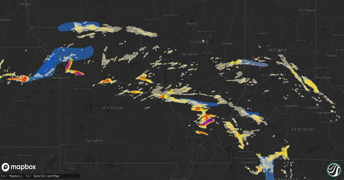
Hail Map on June 30, 2023
Get this storm
June 30 map
$229
one time, instant access
Download today. No call, no setup
Keep the $229
Bought the map and want the full workflow? Apply the entire $229 to a subscription within 7 days. None of it is wasted.
Every map, not just this one
This buys you this map. Subscription and you get every map we run, in the markets you choose from a few cities to whole states to nationwide. Plus real-time alerts the moment a storm fires.
Contact data
Name, contact info, occupancy, even credit band for addresses in the footprint. You go from where it hit to who to call.
Become the source they trust
Unlimited branding weather history reports on demand. You already have the documented answer ready for the property owner, and you are the one who showed up with it.
Property data and RoofTrace estimates
Pull up any address you have got, its value and the exact code rules for that jurisdiction, straight from One Click Code. Then RoofTrace estimates the squares, pitch, and roof value, priced the way you price.
States Impacted by Hail Map on June 30, 2023
Storm reports
Iowa
| Date | Description |
|---|---|
| 06/30/20238:30 AM CDT | Reported by kiic radio. |
| 06/30/20237:23 AM CDT | Asos station klwd lamoni airport. |
| 06/30/20237:08 AM CDT | Measured by personal weather station. |
New Mexico
| Date | Description |
|---|---|
| 06/29/20239:50 PM CDT | Damage to windows and skylights. |
Maryland
| Date | Description |
|---|---|
| 06/30/20233:46 PM CDT | Trees and wires blew down near the intersection of us-1 washington boulevard and kit kat road. |
| 06/30/20233:43 PM CDT | Trees blew down near the intersection of overheart lane and pressed gentian. |
| 06/30/20233:35 PM CDT | Trees blew down near broken land parkway and us-29 columbia pike. |
| 06/30/20233:35 PM CDT | Trees and poles blew down on broken land parkway between hickory ridge road and us-29 columbia pike. |
| 06/30/20233:33 PM CDT | Trees blew down around the 10000 block of green view way. |
| 06/30/20233:33 PM CDT | Trees blew down around the 10000 blcok of green view way. |
| 06/30/20233:32 PM CDT | Trees blew down in the 6000 block of lochridge road. |
| 06/30/20233:29 PM CDT | Tree down onto road at 10000 green view way |
Alabama
| Date | Description |
|---|---|
| 06/30/20233:51 PM CDT | Tree down reports in various locations of the county. |
| 06/30/20233:16 PM CDT | Several trees down near smiths station... Al. |
| 06/30/20233:10 PM CDT | Tree knocked down... Crushing camper. |
| 06/30/20232:56 PM CDT | Several trees down near beulah... Al. |
| 06/30/20232:49 PM CDT | Several trees down around valley... Al. |
| 06/30/20232:42 PM CDT | Several trees down around lanett... Al. |
| 06/30/20232:07 PM CDT | Corrects previous tstm wnd gst report from 2 nw wedowee... Al for wind speed. Mesonet station wedowee recorded a wind gust to 58 mph. |
| 06/30/20232:07 PM CDT | Trees blown down at various locations in the county. |
| 06/30/20231:28 PM CDT | Trees down at several locations in the county. |
| 06/30/202312:46 PM CDT | A few trees blown down in the centre area... Mainly on the east side of town. |
| 06/30/202312:36 PM CDT | Tree down blocking county rd 155. |
Oklahoma
| Date | Description |
|---|---|
| 06/29/20237:35 PM CDT | A local report indicates 59 MPH wind near 3 N Putnam |
| 06/29/20237:00 PM CDT | A local report indicates 72 MPH wind near 4 WNW Bessie |
| 06/29/20237:00 PM CDT | A local report indicates 72 MPH wind near 4 WNW Bessie |
Tennessee
| Date | Description |
|---|---|
| 06/30/20236:52 PM CDT | Tree on house... Power outages across the county. |
| 06/30/20236:52 PM CDT | Corrects previous tstm wnd dmg report from red boiling spring. Tree on house near lafayette road and east main street. Power outages across the county. |
| 06/29/20239:20 PM CDT | Corrects previous tstm wnd dmg report from 3 ssw franklin. Large limb punched hole through roof of home. |
| 06/29/20239:20 PM CDT | Corrects previous tstm wnd dmg report from 3 ssw franklin. Large limb punched hole through roof of home along heathersett drive. |
| 06/29/20239:10 PM CDT | Trees down across county... Power lines down. Likely caused by outflow well ahead of storms. |
| 06/29/20239:01 PM CDT | Corrects previous tstm wnd dmg report from 2 nne spring hill. Multiple trees down in the spring hill area. Time estimated on radar. |
| 06/29/20239:01 PM CDT | Multiple trees down. Time estimated on radar. |
| 06/29/20239:00 PM CDT | Corrects previous tstm wnd dmg report from 3 sw antioch. A couple trees down in lenox village. |
| 06/29/20238:59 PM CDT | Large tree limb broken. Time estimated on radar. |
| 06/29/20238:55 PM CDT | Corrects previous tstm wnd dmg report from 4 e brentwood. Large tree down blocking road. Time estimated on radar. |
| 06/29/20238:53 PM CDT | Corrects previous tstm wnd dmg report from 4 ese brentwood. Multiple trees and power lines down near concord road and sunset road. |
| 06/29/20238:53 PM CDT | Multiple trees and power lines down. |
| 06/29/20238:52 PM CDT | A couple trees down in lenox village. |
| 06/29/20238:45 PM CDT | Corrects previous tstm wnd dmg report from 1 wnw smyrna. Tree down blocking rock springs road near mason tucker drive. Time estimated on radar. |
| 06/29/20238:45 PM CDT | Corrects previous tstm wnd dmg report from 1 wnw smyrna. Tree down blocking road. Time estimated on radar. |
| 06/29/20238:45 PM CDT | Large limb punched hole through roof of home. |
| 06/29/20238:43 PM CDT | Corrects previous tstm wnd dmg report from 3 ne antioch. Tree fell on car near long hunter lane and nashboro boulevard. Time estimated on radar. |
| 06/29/20238:43 PM CDT | Tree fell on car. Time estimated on radar. |
| 06/29/20238:40 PM CDT | Corrects previous tstm wnd dmg report from 2 sse belinda city. Two power poles snapped near central pike and lohman road. About 8200 power outages across wilson county. |
| 06/29/20238:40 PM CDT | Corrects previous tstm wnd dmg report from 2 sse belinda city. Two power poles snapped in this area. About 8200 power outages across wilson county. |
| 06/29/20238:34 PM CDT | A local report indicates 60 MPH wind near 2 S Mount Juliet |
| 06/29/20238:28 PM CDT | Corrects previous tstm wnd dmg report from 3 w nashville. Large tree down blocking dr walter s davis road. Time estimated on radar. |
| 06/29/20238:28 PM CDT | Large tree down blocking the road. Time estimated on radar. |
| 06/29/20238:27 PM CDT | Two power poles snapped in this area. About 8200 power outages across wilson county. |
| 06/29/20238:20 PM CDT | Corrects previous tstm wnd dmg report from 1 nnw hendersonville. Large tree down near east main street and park road. |
| 06/29/20238:20 PM CDT | Large tree down. |
| 06/29/20238:16 PM CDT | Tree down blocking road. Time estimated on radar. |
| 06/29/20238:09 PM CDT | Large tree down blocking road. Time estimated on radar. |
| 06/29/20237:58 PM CDT | Several trees down on hwy 31 between gallatin and westmoreland. |
| 06/29/20237:58 PM CDT | Corrects previous tstm wnd dmg report from 2 w orlinda. Multiple trees and power lines down near highway 49 e and east church street. Widespread power outages across ro |
| 06/29/20237:58 PM CDT | Multiple trees and power lines down. Widespread power outages across robertson county. |
| 06/29/20237:45 PM CDT | Corrects previous tstm wnd dmg report from 6 ssw bethpage. Multiple trees down across brights lane. Time estimated on radar. |
| 06/29/20237:44 PM CDT | Corrects previous tstm wnd dmg report from 6 ne cedar hill. Tree on house near highway 161 and corbin sneed road. Power lines down across the county. |
| 06/29/20237:44 PM CDT | Tree on house... Power lines down across the county. |
| 06/29/20237:16 PM CDT | Multiple trees down across road. Time estimated on radar. |
Virginia
| Date | Description |
|---|---|
| 06/30/20234:48 PM CDT | County 911 reports a tree down near the corner of perimeter rd and maracossic dr. |
| 06/30/20235:50 AM CDT | Trees down at the intersection of oak grove road... And superior lane. One tree blocking the roadway. |
| 06/30/20235:10 AM CDT | A few trees down. |
Texas
| Date | Description |
|---|---|
| 06/30/20236:44 PM CDT | Peak wind gust measured by the west texas mesonet. Additional severe caliber gusts occurred between 6:38 and 6:45 pm... Including a 70 mph wind gust at 6:38 pm. |
| 06/30/20236:38 PM CDT | Measured by the west texas mesonet. Additional severe caliber gusts through the observation time at 6:40 pm. |
| 06/30/20235:20 PM CDT | Measured by the west texas mesonet. A gust to 60 mph was also measwured at 5:19 pm. |
| 06/30/20234:55 PM CDT | Downed power poles and trees between belding and west side of fort stockton. Roof blown off of garage. |
| 06/30/20234:46 PM CDT | From west texas mesonet station. |
| 06/30/20234:45 PM CDT | A local report indicates 64 MPH wind near 1 ENE Mclean |
| 06/30/20232:50 PM CDT | Mostly nickel size with a few quarter size hail along i-40 between eastern and lakeside. |
| 06/30/20231:43 AM CDT | A local report indicates 63 MPH wind near Amarillo 15 NNW |
| 06/29/202311:28 PM CDT | A local report indicates 66 MPH wind near 3 ENE Albany |
| 06/29/202311:12 PM CDT | A local report indicates 67 MPH wind near 1 NW Haskell |
| 06/29/20239:38 PM CDT | A local report indicates 62 MPH wind near 5 W Rotan |
| 06/29/20238:56 PM CDT | A local report indicates 89 MPH wind near 3 E Snyder |
| 06/29/20238:01 PM CDT | A local report indicates 61 MPH wind near 3 WNW Fluvanna |
| 06/29/20237:38 PM CDT | West texas mesonet. |
North Carolina
| Date | Description |
|---|---|
| 06/29/20239:53 PM CDT | Trees down resulting in power outages. |
| 06/29/20239:13 PM CDT | Trees down resulting in power outages. |
| 06/29/20239:02 PM CDT | Several reports of trees down in the area. Power outages also noted. |
| 06/29/20238:45 PM CDT | Emergency management reported multiple trees down... Along with damage to a car and a non-residential building/structures along mangum ct. Time estimated by radar. |
Indiana
| Date | Description |
|---|---|
| 06/30/20231:40 AM CDT | A local report indicates 70 MPH wind near Darmstadt |
| 06/30/202312:35 AM CDT | Report from mping: half dollar |
| 06/30/202312:26 AM CDT | Trees down on white road. |
| 06/30/202312:25 AM CDT | A local report indicates 60 MPH wind near Knightsville |
| 06/30/202312:19 AM CDT | Numerous trees and large branches down. Time estimated from radar. |
| 06/30/202312:04 AM CDT | Several trees down across western half of the county especially. |
| 06/29/202311:58 PM CDT | Tree down across road. |
| 06/29/202311:47 PM CDT | Tree blown down across hopewell road |
| 06/29/202311:30 PM CDT | Half mile swath of trees downed near iron mine road and 1000 south. Appears to be straight line wind per emergency manager. Time estimated from radar. |
| 06/29/202311:05 PM CDT | Several trees downed in town. |
| 06/29/202310:56 PM CDT | Multiple small trees downed near a shed. |
| 06/29/202310:50 PM CDT | A local report indicates 1.00 inch wind near 3 N Waldron |
| 06/29/20239:45 PM CDT | A localized area of stronger winds damaged trees... A chimney... And a car wash northwest of downtown. Time estimated from radar. |
| 06/29/20238:35 PM CDT | Several large limbs and a few trees downed or uprooted in downtown middlebury. |
Mississippi
| Date | Description |
|---|---|
| 06/30/20233:55 PM CDT | Tree downed on ms hwy 14 east of kosciusko. |
Georgia
| Date | Description |
|---|---|
| 06/30/20236:39 PM CDT | Powerlines down at highway 16 e and joe cox rd. |
| 06/30/20234:00 PM CDT | Downed powerlines on sr 109 |
| 06/30/20233:15 PM CDT | Top of a large oak tree broken off near the intersection of twin chapel rd and maudie ln. |
| 06/30/20233:00 PM CDT | Several trees reported down on rush creek hwy and chestnut grove rd. |
| 06/30/20232:42 PM CDT | Powerlines down at walton rd and martin mill rd. |
| 06/30/20232:22 PM CDT | Two trees down along salem chipley rd near turkey creek. |
| 06/30/20232:21 PM CDT | Tree down along salem rd near oak grove rd. |
| 06/30/20232:20 PM CDT | A couple of trees down near the intersection of reidsboro rd and drew allen rd per em. |
| 06/30/20232:19 PM CDT | Two trees down along new hutchinson mill rd near cannonville rd and bartley rd. |
| 06/30/20232:18 PM CDT | Multiple reports of trees down ga 27 and i85 near bartley rd and whitesville rd.. |
| 06/30/20232:16 PM CDT | Multiple reports of trees and powerlines down along upper big springs rd near lower big springs rd. |
| 06/30/20232:15 PM CDT | Multiple trees down with some on houses in the town of hogansville. |
| 06/30/20232:14 PM CDT | Two reports of trees down along upper big springs rd near the i85 overpass between s davis rd and callaway church rd. |
| 06/30/20232:14 PM CDT | Tree down at towns rd and greenville rd. |
| 06/30/20232:14 PM CDT | Two reports of trees down near mountville at camp viola rd and charles heard rd. |
| 06/30/20232:14 PM CDT | Multiple reports of trees down along west point rd between bradfield dr and hudson rd. |
| 06/30/20232:14 PM CDT | Downed powerlines on sr 109 |
| 06/30/20232:13 PM CDT | Multiple reports of trees and powerlines down between hamilton rd and truitt ave and lafayette pkwy and w lukken industrial dr. |
| 06/30/20232:12 PM CDT | Multiple reports of trees and powerlines down north of lafayette pkwy... East of martha berry hwy... And south and west of davis rd bypass. |
| 06/30/20232:12 PM CDT | Numerous reports of trees and powerlines down north of vernon st... West of martha berry hwy... East of country club rd... And south of west point lake. |
| 06/30/20232:11 PM CDT | Tree down at perkins rd and sims rd. |
| 06/30/20232:10 PM CDT | Tree down on powerlines at tin bridge rd and cedar ridge rd. |
| 06/30/20232:05 PM CDT | Numerous trees and powerlines down with some on houses in the town of hogansville. |
| 06/30/20232:05 PM CDT | Tree and powerlines down along lovac davis rd near indian bend dr as well as garrett rd. |
| 06/30/20232:00 PM CDT | Tree down at classic rd and lowery rd northeast of grantville. |
| 06/30/20231:59 PM CDT | Tree down near the intersection of hwy 29 and college st. |
| 06/30/20231:50 PM CDT | Tree down at along s highway 29 near college st in moreland. |
| 06/30/20231:50 PM CDT | Tree down near the intersection of gordon rd and alex stephens rd. |
| 06/30/20231:45 PM CDT | Two trees reported snapped at the 200 block of handy rd. |
| 06/30/20231:45 PM CDT | Tree on house at bowers dr and holbrooke dr... Southwest of newnan. |
| 06/30/20231:45 PM CDT | Tree down at boy scout rd and handy rd. |
| 06/30/20231:44 PM CDT | Tree reported down at the intersection of handy rd and boy scout rd. |
| 06/30/20231:40 PM CDT | Multiple trees down across northern heard... Exact location of damage uncertain. |
| 06/30/20231:40 PM CDT | Tree down on a home at the 100 block of winchester dr. |
| 06/30/20231:38 PM CDT | Powerlines down at highway 16 e and joe cox rd. |
| 06/30/20231:38 PM CDT | Tree down at the 900 block of south hwy 100 to the south of bowdon. |
| 06/30/20231:36 PM CDT | Powerlines down at mary freeman rd and lower fayetteville rd. |
| 06/30/20231:36 PM CDT | Powerlines down at mary freeman rd and fox ridge dr. |
| 06/30/20231:35 PM CDT | Tree down on powerlines on the 1700 block of davenport mill rd. |
| 06/30/20231:32 PM CDT | Powerlines down at festiva dr and sweetbriar rd. |
| 06/30/20231:32 PM CDT | Powerlines down at franklin rd and newnan bypass rd. |
| 06/30/20231:30 PM CDT | Tree down and powerlines down at snooky dr and winndale rd. |
| 06/30/20231:30 PM CDT | Powerlines down at lazenby rd and welcome rd. |
| 06/30/20231:30 PM CDT | Tree down near the intersection of tommy lee cook rd and jim starr rd. |
| 06/30/20231:30 PM CDT | Powerline down at azalea dr and windsor rd. |
| 06/30/20231:20 PM CDT | Tree and powerlines down on mill pond crossing... Leading to a power outage in the subdivision. |
| 06/30/20231:12 PM CDT | Tree down at the 200 block of riviera dr. |
| 06/30/202312:58 PM CDT | Trees and powerlines reported down. |
| 06/30/202312:56 PM CDT | Trees and powerlines reported down. |
| 06/30/202312:55 PM CDT | Multiple trees and powerlines down along seab green rd with one tree going through home. |
| 06/30/202312:54 PM CDT | Tree down on levans rd near the interstate bridge. |
| 06/30/202312:54 PM CDT | Trees and powerlines reported down. |
| 06/30/202312:50 PM CDT | Trees and powerlines reported down. |
Missouri
| Date | Description |
|---|---|
| 06/30/20236:58 PM CDT | A local report indicates 1.00 inch wind near 1 ENE Kearney |
| 06/30/20236:56 PM CDT | Report from mping: quarter |
| 06/30/20236:55 PM CDT | Report from mping: trees uprooted or snapped; roof blown off. Time estimated from radar. |
| 06/30/20236:52 PM CDT | 3 limbs down and flagpole bent over. |
| 06/30/20236:50 PM CDT | 12-inch diameter trees limbs were thrown 40 ft. |
| 06/30/20236:45 PM CDT | An eighteen-wheeler fell on its side in the walmart parking lot in arnold... Missouri... Next to a heavily damaged fireworks tent. |
| 06/30/20236:41 PM CDT | Numerous tree branches up to 4 inches in diameter littered the ground. |
| 06/30/20236:39 PM CDT | Corrects previous tstm wnd dmg report from 1 ene oakville. Report from mping: trees uprooted or snapped; roof blown off. Time estimated from radar. |
| 06/30/20236:39 PM CDT | Corrects previous tstm wnd dmg report from 1 ne oakville. 3 limbs down and flagpole bent over. |
| 06/30/20236:29 PM CDT | Report from mping: quarter |
| 06/30/20236:28 PM CDT | 5 trees the size of power poles blown down in high ridge... Mo. |
| 06/30/20236:16 PM CDT | Large tree blow over. |
| 06/30/20236:12 PM CDT | Report from mping: golf ball |
| 06/30/20236:10 PM CDT | A local report indicates 1.00 inch wind near 1 ENE Eureka |
| 06/30/20236:08 PM CDT | A local report indicates 1.00 inch wind near 1 E Eureka |
| 06/30/20236:06 PM CDT | Half dollar size and larger hail in eureka... Legends area. |
| 06/30/20236:05 PM CDT | A local report indicates 1.50 inch wind near 2 NNE Eureka |
| 06/30/20236:02 PM CDT | At the intersection of telegraph road and cliff cave road. |
| 06/30/20236:01 PM CDT | A local report indicates 1.00 inch wind near 1 ESE Mehlville |
| 06/30/20236:00 PM CDT | A local report indicates 1.75 inch wind near 1 ESE Wildwood |
| 06/30/20235:50 PM CDT | A local report indicates 1.00 inch wind near 1 NNE Oakville |
| 06/30/20235:32 PM CDT | A local report indicates 1.50 inch wind near Gasconade |
| 06/30/20235:15 PM CDT | Quarter-sized hail at mark lieneke farm. |
| 06/30/20235:08 PM CDT | Chamois resident observed hail between peas up to ping pong balls. |
| 06/30/20235:06 PM CDT | A local report indicates 2.00 inch wind near Chamois |
| 06/30/20235:03 PM CDT | A local report indicates 1.50 inch wind near 3 SW Chamois |
| 06/30/20234:47 PM CDT | A local report indicates 1.00 inch wind near Mokane |
| 06/30/20237:52 AM CDT | A few tree limbs down. |
| 06/30/20237:40 AM CDT | Large tree branches down throughout town. Power remains out. |
| 06/30/20237:12 AM CDT | A local report indicates 60 MPH wind near 7 N Blythedale |
| 06/30/20231:10 AM CDT | Law enforcement estimated 60 mph wind through kirksville... Which caused a tree limb to come down on a power line. |
| 06/29/202311:42 PM CDT | Tree down in trenton. |
| 06/29/202311:10 PM CDT | Isle of capri casino. |
| 06/29/202310:51 PM CDT | A local report indicates 60 MPH wind near 2 NNE Altamont |
| 06/29/202310:45 PM CDT | Cameron memorial airport. |
| 06/29/202310:44 PM CDT | Tree blocking highway c... 4 miles north of cameron. |
| 06/29/202310:03 PM CDT | A local report indicates 82 MPH wind near 1 NNE Saint Joseph Airp |
| 06/29/202310:03 PM CDT | Delayed report: tree damage shown on social media |
| 06/29/202310:03 PM CDT | Delayed report: tree damage shown on social media in the stone crest area of st. Joseph. |
| 06/29/20239:58 PM CDT | A local report indicates 61 MPH wind near 1 NNE Saint Joseph Airp |
| 06/29/20239:31 PM CDT | Report from mping: quarter |
| 06/29/20239:19 PM CDT | A local report indicates 1.00 inch wind near Cool Valley |
| 06/29/20239:18 PM CDT | A local report indicates 1.00 inch wind near Ferguson |
| 06/29/20239:17 PM CDT | Report from mping: quarter |
| 06/29/20239:16 PM CDT | A local report indicates 1.50 inch wind near Woodson Terrace |
| 06/29/20239:14 PM CDT | A local report indicates 1.00 inch wind near 1 SSW Saint John |
| 06/29/20239:12 PM CDT | A local report indicates 1.00 inch wind near Saint John |
| 06/29/20239:12 PM CDT | A local report indicates 1.00 inch wind near 1 SE Woodson Terrace |
| 06/29/20239:10 PM CDT | Report from mping: 3-inch tree limbs broken; power poles broken. |
| 06/29/20239:10 PM CDT | Report from mping: quarter |
| 06/29/20239:10 PM CDT | Report from mping: qu |
| 06/29/20239:09 PM CDT | Large tree down blocking road. |
| 06/29/20239:04 PM CDT | Multiple trees on roadways. |
| 06/29/20239:01 PM CDT | Large limbs down on roadway. |
| 06/29/20238:10 PM CDT | A local report indicates 1.25 inch wind near 1 ENE Overland |
| 06/29/20238:07 PM CDT | A local report indicates 1.50 inch wind near Hawk Point |
| 06/29/20238:05 PM CDT | A local report indicates 1.25 inch wind near Hawk Point |
| 06/29/20238:01 PM CDT | A local report indicates 1.25 inch wind near 2 WNW Olivette |
| 06/29/20237:53 PM CDT | Lexington middle school. |
| 06/29/20237:52 PM CDT | Delayed report from social media/broadcast media. |
| 06/29/20237:52 PM CDT | A local report indicates 1.00 inch wind near Lexington |
| 06/29/20237:52 PM CDT | Delayed report: social media report with photo attached of larger than 4 inch hail. |
| 06/29/20237:40 PM CDT | Shirkey golf club in richmond. |
| 06/29/20237:39 PM CDT | Caseys general store in richmond. |
| 06/29/20237:30 PM CDT | Trex gas station near lathrop. |
| 06/29/20237:20 PM CDT | A local report indicates 1.50 inch wind near Middletown |
| 06/29/20237:18 PM CDT | A local report indicates 1.50 inch wind near 2 SW Middletown |
| 06/29/20237:18 PM CDT | A local report indicates 1.50 inch wind near 3 SW Middletown |
| 06/29/20237:13 PM CDT | Reported via social media. |
| 06/29/20237:12 PM CDT | 2-3 minutes of golf ball sized hail at this location. Ground covered with smaller hail. |
| 06/29/20237:08 PM CDT | Report via social media. |
| 06/29/20237:04 PM CDT | Report from mping: quarter |
| 06/29/20237:01 PM CDT | Report via social media. |
| 06/29/20237:01 PM CDT | Report via social media. |
Kentucky
| Date | Description |
|---|---|
| 06/30/20236:56 PM CDT | A local report indicates 1.00 inch wind near Scottsville |
| 06/30/20236:45 PM CDT | Roof and tree damage from thunderstorm winds. |
| 06/30/20236:39 PM CDT | Trees down in gamaliel. |
| 06/30/20236:39 PM CDT | A local report indicates 1.00 inch wind near Scottsville |
| 06/30/20236:38 PM CDT | A local report indicates 1.00 inch wind near Fountain Run |
| 06/30/20236:38 PM CDT | Trees down in fountain run. |
| 06/30/20236:38 PM CDT | Tree down in yard. |
| 06/30/20236:35 PM CDT | Trees down thunderstorm wind damage. |
| 06/30/20236:35 PM CDT | Trees and powerlines down near the crofton shelter. |
| 06/30/20236:30 PM CDT | Pole barn metal partially peeled off. |
| 06/30/20236:16 PM CDT | A local report indicates 1.50 inch wind near 3 SW Lucas |
| 06/30/20236:09 PM CDT | Two trees down on roseville rd. |
| 06/30/20235:49 PM CDT | Tree down at intersection of siddens and finney rd. |
| 06/30/20235:45 PM CDT | A local report indicates 1.50 inch wind near Providence |
| 06/30/20235:40 PM CDT | A local report indicates 1.00 inch wind near 1 SSE Glasgow |
| 06/30/20235:35 PM CDT | Tree down on south green street. |
| 06/30/20232:48 AM CDT | Tree down blocking one lane on state 1274 near state route 36. Time estimated based on radar. |
| 06/30/20232:40 AM CDT | Tree down on power lines. Time estimated based on radar. |
| 06/30/20232:38 AM CDT | Phone line down due to winds. Time estimated based on radar. |
| 06/30/20232:35 AM CDT | Delayed report. Multiple instances of wind damage were observed across hancock county. |
| 06/30/20232:30 AM CDT | Large tree limb fell on roof of house. |
| 06/30/20231:23 AM CDT | Trees reported down in multiple spots of cordova road. Time estimated by radar. |
| 06/30/20231:20 AM CDT | Numerous trees down around the corinth... Kentucky area... Especially along blanchet road. |
| 06/30/20231:07 AM CDT | Trees reported down along keefer road. Time estimated by radar. |
| 06/30/20231:03 AM CDT | Trees down on heekin road in the lawrenceville area. Time estimated by radar. |
| 06/30/20231:01 AM CDT | Trees reported down on barnes road in williamstown ky. |
| 06/30/202312:50 AM CDT | Trees down along taft highway near ky 36. Time estimated by radar data. |
| 06/30/202312:50 AM CDT | Trees down on burgess road. Time estimated by radar. |
| 06/30/202312:48 AM CDT | *** 1 inj *** heavily damaged home with minor injury treated on scene. |
| 06/30/202312:45 AM CDT | *** 1 inj *** large trees down. Four homes damaged from trees. Unknown number of injuries... At least one. Telphone poles snapped. |
| 06/30/202312:22 AM CDT | Trees and powerlines down. |
| 06/30/202312:22 AM CDT | Viewer report of downed trees and a roof blown off a mobile home. |
| 06/29/202311:30 PM CDT | One tree downed and another uprooted. |
| 06/29/202311:10 PM CDT | Tree damage reported near daviess county fish and game. Time estimated by radr. |
| 06/29/20237:40 PM CDT | Tree down on trimble rd. |
| 06/29/20237:39 PM CDT | Tree down on tamara rd. |
| 06/29/20237:38 PM CDT | Tree down on east gallatin street. |
| 06/29/20237:25 PM CDT | Dimes and quarters near franklin. |
Illinois
| Date | Description |
|---|---|
| 06/30/20236:56 PM CDT | Estimated 60 mph winds and nickel sized hail. |
| 06/30/20236:56 PM CDT | Trees and power lines down at the intersection of st. Paul street and gardner street. |
| 06/30/20236:55 PM CDT | Lots of mature trees blown down onto bohleysville road south southwest of millstadt. Via facebook. |
| 06/30/20236:49 PM CDT | Corrects previous tstm wnd dmg report from 2 se columbia. Large tree blown over. Limbs blocking illinois route 3. |
| 06/30/20236:46 PM CDT | Corrects previous tstm wnd dmg report from 1 se columbia. Trees and power lines down at the intersection of st. Paul street and gardner street. |
| 06/30/20236:31 PM CDT | A local report indicates 1.00 inch wind near 1 SE West Frankfort |
| 06/30/20236:31 PM CDT | A local report indicates 1.25 inch wind near West Frankfort |
| 06/30/20236:05 PM CDT | A local report indicates 1.00 inch wind near Cypress |
| 06/30/20236:03 PM CDT | A local report indicates 1.75 inch wind near 3 SSE Buncombe |
| 06/30/20235:54 PM CDT | Damaged caused by baseball sized hail. |
| 06/30/20235:44 PM CDT | A local report indicates 2.75 inch wind near 1 N Pittsburg |
| 06/30/20235:40 PM CDT | A local report indicates 1.75 inch wind near 1 SE Carbondale |
| 06/30/20235:37 PM CDT | Report from mping: quarter |
| 06/30/20235:35 PM CDT | A local report indicates 2.75 inch wind near Johnston City |
| 06/30/20235:35 PM CDT | Corrects previous hail report from johnston city. Public has dents to car and cracked windshield. |
| 06/30/20235:34 PM CDT | Report from mping: quarter |
| 06/30/20235:31 PM CDT | A local report indicates 1.50 inch wind near 1 NE Marion |
| 06/30/20235:30 PM CDT | Major damage to multiple vehicles at car dealership. |
| 06/30/20235:28 PM CDT | Airplane at airport has busted windows. |
| 06/30/20235:27 PM CDT | A local report indicates 1.00 inch wind near 1 ENE Marion |
| 06/30/20235:25 PM CDT | A local report indicates 1.50 inch wind near Anna |
| 06/30/20235:25 PM CDT | Report from mping: golf ball |
| 06/30/20235:24 PM CDT | Numerous damaged vehicles from golf ball sized hail. |
| 06/30/20235:24 PM CDT | Damage to the ballpark. |
| 06/30/20235:22 PM CDT | A local report indicates 1.75 inch wind near 2 ESE Crainville |
| 06/30/20235:21 PM CDT | A local report indicates 1.00 inch wind near 1 SE Crainville |
| 06/30/20235:20 PM CDT | A local report indicates 3.00 inch wind near 2 S Energy |
| 06/30/20235:20 PM CDT | A local report indicates 1.75 inch wind near Anna |
| 06/30/20235:19 PM CDT | Report from mping: quarter |
| 06/30/20235:01 PM CDT | Corrects previous hail report from 3 nne makanda. |
| 06/30/20235:00 PM CDT | A local report indicates 1.75 inch wind near 5 NE Makanda |
| 06/30/20234:52 PM CDT | A local report indicates 1.25 inch wind near 3 NNE Makanda |
| 06/30/20237:34 AM CDT | Widespread tree damage around town. Numerous large trees blown down as well as tree limbs and power lines. Via pictures on facebook. |
| 06/30/20233:38 AM CDT | Report from mping: 3-inch tree limbs broken; power poles broken. |
| 06/30/20233:05 AM CDT | Report from mping: 3-inch tree limbs broken; power poles broken. |
| 06/30/20233:00 AM CDT | Public estimated 60 mph winds. |
| 06/30/20232:30 AM CDT | Multiple reports of trees and limbs down around quincy. Time estimated from radar. |
| 06/29/202310:50 PM CDT | Report of varying hail sizes ranging from pea... Dime... And nickel. A few measured in at 1 inch. |
| 06/29/202310:06 PM CDT | Report from mping: trees uprooted or snapped; roof blown off. |
| 06/29/20239:56 PM CDT | Report from mping: 3-inch tree limbs broken; power poles broken. |
| 06/29/20239:49 PM CDT | Report from mping: quarter |
| 06/29/20239:40 PM CDT | Multiple tree limbs 6 inches in diameter down along sheridan ave. One tree 14 inches in diameter down in an alley way behind sheridan ave. Time estimated by radar. |
| 06/29/20239:30 PM CDT | Report from mping: 3-inch tree limbs broken; power poles broken. |
| 06/29/20238:56 PM CDT | Reports of power lines down on golf course rd and n west st. |
| 06/29/20238:53 PM CDT | Large tree down on state route 142 and county road 200 e. |
| 06/29/20238:48 PM CDT | Report from mping: quarter |
| 06/29/20238:43 PM CDT | A local report indicates 70 MPH wind near 1 WSW Mount Vernon |
| 06/29/20238:30 PM CDT | A local report indicates 1.25 inch wind near 4 SE Troy |
| 06/29/20238:30 PM CDT | Tree fell on a mobile home and damaged the home. Large maple tree snapped as well. |
| 06/29/20238:30 PM CDT | A local report indicates 1.75 inch wind near 4 W Tamaroa |
| 06/29/20238:25 PM CDT | Multiple trees and powerlines down. |
| 06/29/20238:10 PM CDT | Widespread wind damage around town. Numerous large trees blown down... One fell onto a house. Also... A number of trees blown down onto illinois route 15. Lots of tree |
| 06/29/20237:57 PM CDT | Large tree down. |
| 06/29/20237:54 PM CDT | Barn and machine shed destroyed. |
| 06/29/20237:53 PM CDT | Wind damage reported throughout the town of nashville... Il by the county emergency manager. |
| 06/29/20237:47 PM CDT | Report from mping: trees uprooted or snapped; roof blown off. |
| 06/29/20237:45 PM CDT | Report from mping: 3-inch tree limbs broken; power poles broken. |
| 06/29/20237:42 PM CDT | Heavily-damaged outbuildings and barns. |
| 06/29/20237:37 PM CDT | Multiple large treetops blown off. |
| 06/29/20237:37 PM CDT | 4 tree limbs down. |
| 06/29/20237:36 PM CDT | Report from mping: quarter |
| 06/29/20237:34 PM CDT | Corrects previous tstm wnd dmg report from venedy. Widespread tree damage around town. Numerous large trees blown down as well as tree limbs and power lines. Via pictur |
| 06/29/20237:31 PM CDT | Significant tree damage in st. Libory. Home sustained damage to the roof and several limbs snapped. |
| 06/29/20237:20 PM CDT | 8 ft diameter tree blown over. |
| 06/29/20237:16 PM CDT | Em at the freeburg ema office reported wind gust and power outage. |
| 06/29/20237:13 PM CDT | A local report indicates 1.75 inch wind near 2 SSE Benton |
| 06/29/20237:13 PM CDT | Corrects previous hail report from 2 sse benton. |
| 06/29/20237:11 PM CDT | Damage city wide. Power poles blown down and top of silo blown off. Various size limbs all over roads. |
| 06/29/20237:05 PM CDT | Tree down in smithton... Il. Picture via twitter. |
| 06/29/20237:04 PM CDT | Large tree blown over. Limbs blocking hwy 3. |
| 06/29/20237:02 PM CDT | A local report indicates 1.00 inch wind near 1 SSW Mcleansboro |
| 06/29/20237:02 PM CDT | Corrects previous hail report from 1 ssw mcleansboro. |
Kansas
| Date | Description |
|---|---|
| 06/30/20236:58 PM CDT | The asos in hill city |
| 06/30/20236:57 PM CDT | Spotter reported quarter size hail 1 mile east of hill city. Time estimated via radar. |
| 06/30/20236:55 PM CDT | Spotter reported quarter size hail and estimated wind gusts up to 80 mph. |
| 06/30/20236:50 PM CDT | A local report indicates 1.00 inch wind near 7 S Manhattan |
| 06/30/20236:40 PM CDT | Social media report. |
| 06/30/20236:40 PM CDT | A local report indicates 1.00 inch wind near 3 WNW Manhattan |
| 06/30/20236:35 PM CDT | Facebook report of nickel to quarter size hail 13 miles northeast of hoxie. Time estimated via radar. |
| 06/30/20236:31 PM CDT | Public reported 50-60 mph wind gusts. |
| 06/30/20236:10 PM CDT | Large tree limb down. |
| 06/30/20236:10 PM CDT | Gas station employee estimated 60 mph wind gusts. |
| 06/30/20235:55 PM CDT | A local report indicates 1.25 inch wind near 5 SSE Milford |
| 06/30/20235:49 PM CDT | Mesonet station up841 1.9 w monument |
| 06/30/20235:45 PM CDT | A local report indicates 60 MPH wind near 5 SSE Milford |
| 06/30/20235:40 PM CDT | A local report indicates 1.00 inch wind near 4 S Wakefield |
| 06/30/20235:29 PM CDT | The awos in colby |
| 06/30/20235:25 PM CDT | The awos in colby |
| 06/30/20235:25 PM CDT | Facebook report of quarter size hail 4 miles north of colby. Time estimated via radar. |
| 06/30/20235:17 PM CDT | Report via facebook. |
| 06/30/20235:03 PM CDT | Lots of pea-sized hail as well. |
| 06/30/20234:41 PM CDT | Off-duty nws employee followed-up to report broken windows associated with wind-driven hail. Additionally... A center pivot was blown over. Power out. |
| 06/30/20234:41 PM CDT | Corrects previous hail report from 13 n edson. Hail up to 2 inches in diameter. |
| 06/30/20234:41 PM CDT | Received from facebook. |
| 06/30/20234:41 PM CDT | Off-duty nws employee estimated 80 mph winds. |
| 06/30/20234:41 PM CDT | Reported via facebook. |
| 06/30/20234:40 PM CDT | Powerline blown down from one of the electric poles. Estimated time of report. |
| 06/30/20234:38 PM CDT | Reported at least 60 mph with torrential rain. |
| 06/30/20234:38 PM CDT | A local report indicates 1.00 inch wind near 13 N Edson |
| 06/30/20234:27 PM CDT | Golf ball size hail on highway 27 about 10 miles north of goodland around 3:25 to 3:30 pm mdt. Time estimated via radar. Social media report with picture. |
| 06/30/20234:10 PM CDT | Lots of hail that has broken branches... Windows. |
| 06/29/20239:44 PM CDT | Reported from social media. |
| 06/29/20239:35 PM CDT | A local report indicates 60 MPH wind near 5 E Brookville |
| 06/29/20239:30 PM CDT | Caseys in atchison. |
| 06/29/20239:20 PM CDT | A local report indicates 59 MPH wind near 7 E Tipton |
| 06/29/20239:15 PM CDT | 235th and dempsey road east of mclouth ks. |
| 06/29/20239:05 PM CDT | Power lines down in nortonville. Time estimated by radar. |
| 06/29/20239:03 PM CDT | A local report indicates 1.00 inch wind near Oskaloosa |
| 06/29/20239:01 PM CDT | 14-16 inch tree limbs down. Time estimated radar. |
| 06/29/20239:00 PM CDT | Roof damage at jefferson north high school. Occurred on initial gust front. Time estimated from radar. |
| 06/29/20238:58 PM CDT | Multiple trees down throughout the town of oskaloosa. |
| 06/29/20238:58 PM CDT | 5 inch diameter li |
| 06/29/20238:58 PM CDT | 5 inch diameter limb fell on house. |
| 06/29/20238:57 PM CDT | Power lines down and a structure fire reported in the area. |
| 06/29/20238:53 PM CDT | Spotter reported several large trees snapped 8 feet above the ground... And many large branches broken off. |
| 06/29/20238:53 PM CDT | Delayed report via social media. Images show sections of an outbuilding roof blown off. Time estimated via radar. |
| 06/29/20238:52 PM CDT | Ongoing ping pong ball sized hail. |
| 06/29/20238:48 PM CDT | Corrects previous tstm wnd dmg report from 2 nw grantville. 32 inch diameter tree down at 31st and k-4 highway. |
| 06/29/20238:48 PM CDT | 10 to 12 inch tree branches down at 31st and k-4 highway. |
| 06/29/20238:48 PM CDT | Corrects previous tstm wnd |
| 06/29/20238:35 PM CDT | Time estimated radar. |
| 06/29/20238:35 PM CDT | A local report indicates 60 MPH wind near 1 NNW Russell |
| 06/29/20238:24 PM CDT | Asos station ktop topeka. |
| 06/29/20238:22 PM CDT | Multiple 4 to 8 inch diameter tree branches down near intersection of strait and seward. Time estimated from radar. |
| 06/29/20238:20 PM CDT | Report of at least 8 power poles blown over/snapped from the this evenings storm. |
| 06/29/20238:17 PM CDT | Two to three inch tree branch blown down. |
| 06/29/20238:12 PM CDT | A local report indicates 60 MPH wind near 4 WSW Topeka |
| 06/29/20238:08 PM CDT | 4-5 inch diameter limbs blown down. Estimated 70 to 75 mph winds. |
| 06/29/20238:02 PM CDT | A local report indicates 1.25 inch wind near 4 S Willard |
| 06/29/20237:57 PM CDT | A local report indicates 4.00 inch wind near 2 SSE Maple Hill |
| 06/29/20237:56 PM CDT | A local report indicates 60 MPH wind near 2 NW Dover |
| 06/29/20237:56 PM CDT | A local report indicates 1.50 inch wind near 2 NW Dover |
| 06/29/20237:45 PM CDT | Time estimated radar. Delayed report. |
| 06/29/20237:39 PM CDT | Report via facebook of golf ball size hail accompanied by 30 to 40 mph winds. |
| 06/29/20237:28 PM CDT | Camper overturned at webster lake. |
| 06/29/20237:25 PM CDT | Corrects previous hail report from 4 s stockton. Report via twitter of ping pong ball sized hail... Broken windows at this location. Time estimated from radar. |
| 06/29/20237:25 PM CDT | Report via twitter of ping pong ball sized hail. Time estimated from radar. |
| 06/29/20237:20 PM CDT | A local report indicates 70 MPH wind near Mcfarland |
| 06/29/20237:20 PM CDT | A local report indicates 1.50 inch wind near Mcfarland |
| 06/29/20237:14 PM CDT | Reported relayed via kake of some tree damage in damar. Time est from radar. |
| 06/29/20237:10 PM CDT | Spotter estimated 75 mph wind gusts. |
| 06/29/20237:10 PM CDT | Spotter reported pea to quarter size hail. Time estimated via radar. |
| 06/29/20237:02 PM CDT | The asos in hill city |
| 06/29/20237:00 PM CDT | Corrects previous tstm wnd dmg report from 5 n hill city. As of 8 pm mdt... Graham county emergency management reported up to 15 power poles blown over or snapped by hi |
| 06/29/20237:00 PM CDT | Facebook report indicating that a semi with a load of cows was blown over on highway 283... Just south of town road q. Time estimated via radar. |
Colorado
| Date | Description |
|---|---|
| 06/30/20233:30 PM CDT | Delayed report received 7/1/23. |
| 06/30/20233:19 PM CDT | Brief tornado ... Location estimated by radar. Reported via twitter. |
| 06/30/20232:47 PM CDT | Storm chaser located about 6 miles n of seibert on highway 59 reported a few brief touchdowns/ground circulations between 1:45 and 1:50 pm mdt. |
| 06/30/20232:26 PM CDT | A local report indicates 1.00 inch wind near 3 W Fountain |
| 06/30/20232:26 PM CDT | A local report indicates 2.00 inch wind near 1 SSE Security |
| 06/30/202312:40 PM CDT | Media videoed a tornado for approximately three minutes just south of the elbert county line from 1140-1143 am. No damage reported as the tornado appears to have remain |
| 06/30/202310:20 AM CDT | Strong enough photographic evidence that a tornado briefly touched down. Time estimated to be around 9:20 am. Location also estimated at this time. |
Cities Impacted by Hail Map on June 30, 2023
- Parnell, MO
- Blockton, IA
- Redding, IA
- Bedford, IA
- Benton, IA
- Sheridan, MO
- Lamoni, IA
- Eagleville, MO
- Davis City, IA
- Hatfield, MO
- Blythedale, MO
- Mercer, MO
- Kellerton, IA
- Cainsville, MO
- Mount Ayr, IA
- Grant City, MO
- Clio, IA
- Garden Grove, IA
- Decatur, IA
- Leon, IA
- Allerton, IA
- Grand River, IA
- Lineville, IA
- Corydon, IA
- Humeston, IA
- Seymour, IA
- Unionville, MO
- Powersville, MO
- Princeton, MO
- Sault Sainte Marie, MI
- Monterey, TN
- Crossville, TN
- Pattonsburg, MO
- Green Castle, MO
- Green City, MO
- Ridgeway, MO
- Gilman City, MO
- Gaylesville, AL
- Kahoka, MO
- Luray, MO
- Sedalia, CO
- Cedar Bluff, AL
- Hamilton, IL
- Basco, IL
- Elvaston, IL
- Warsaw, IL
- Keokuk, IA
- Carthage, IL
- Montrose, IA
- Pikeville, TN
- Argyle, IA
- Wayland, MO
- Newtown, MO
- Menlo, GA
- Brimley, MI
- Lucerne, MO
- Harris, MO
- Bethany, MO
- Plymouth, IL
- Farmington, IA
- Alexandria, MO
- Barbeau, MI
- Dafter, MI
- Kinross, MI
- Rising Fawn, GA
- Livonia, MO
- Queen City, MO
- Glenwood, MO
- Lancaster, MO
- Coatsville, MO
- McFall, MO
- Downing, MO
- Cincinnati, IA
- Arbela, MO
- Tennessee, IL
- Saint Patrick, MO
- Revere, MO
- Nauvoo, IL
- Memphis, MO
- Bloomfield, IA
- Exline, IA
- Centerville, IA
- Moulton, IA
- Pollock, MO
- Rockmart, GA
- Cantril, IA
- Mount Sterling, IA
- Eckerman, MI
- Hill City, SD
- Arriba, CO
- Flagler, CO
- Colorado Springs, CO
- Fountain, CO
- Seibert, CO
- Cope, CO
- Trinidad, CO
- Joes, CO
- Vona, CO
- Bethune, CO
- Stratton, CO
- Burlington, CO
- Rye, CO
- Pueblo, CO
- Strasburg, CO
- Idalia, CO
- Avondale, CO
- Saint Francis, KS
- Kanorado, KS
- Goodland, KS
- Levelland, TX
- Branson, CO
- Edson, KS
- Sturgis, KY
- Kim, CO
- Carbondale, IL
- Makanda, IL
- Brewster, KS
- Bird City, KS
- McDonald, KS
- Levant, KS
- Colby, KS
- Atwood, KS
- Carterville, IL
- Marion, IL
- Fort Stockton, TX
- Imperial, TX
- Mokane, MO
- Steedman, MO
- Chamois, MO
- Morrison, MO
- Hermann, MO
- Anton, TX
- Clarendon, TX
- Mclean, TX
- Shamrock, TX
- Energy, IL
- Herrin, IL
- Gem, KS
- Rexford, KS
- Johnston City, IL
- Glasgow, KY
- Cobden, IL
- Jonesboro, IL
- Anna, IL
- Dongola, IL
- Buncombe, IL
- Wakefield, KS
- Chapman, KS
- Junction City, KS
- Pacific, MO
- Hoxie, KS
- Selden, KS
- Pittsburg, IL
- Thompsonville, IL
- Milford, KS
- Kinsley, KS
- West Frankfort, IL
- Scobey, MT
- Bellvue, CO
- Boone, CO
- Union, MS
- Philadelphia, MS
- Aguilar, CO
- Halliday, ND
- Taylor, ND
- Gladstone, ND
- Brockton, MT
- Edgemont, SD
- Goreville, IL
- Smiths Grove, KY
- Froid, MT
- Kosciusko, MS
- Ethel, MS
- Madisonville, KY
- Nebo, KY
- Providence, KY
- Manitou, KY
- Wedowee, AL
- Wadley, AL
- Whitesburg, GA
- Carrollton, GA
- Centre, AL
- Dickinson, ND
- Manning, ND
- Littlefield, TX
- Millport, AL
- Whitetail, MT
- Tebbetts, MO
- Kermit, TX
- Wink, TX
- Hawks, MI
- Hillman, MI
- Lachine, MI
- Posen, MI
- Pritchett, CO
- Las Animas, CO
- Springfield, CO
- Labadie, MO
- Saint Albans, MO
- Villa Rica, GA
- Manchester, GA
- Temple, GA
- Bremen, GA
- Grantville, GA
- Hogansville, GA
- Lefor, ND
- Claude, TX
- Jennings, KS
- Oberlin, KS
- Dresden, KS
- Murphysboro, IL
- Uniontown, KY
- Jacksonville, AL
- Piedmont, AL
- Pine Ridge, SD
- Imperial, MO
- Greenville, GA
- Woodbury, GA
- Ozark, IL
- Creal Springs, IL
- Monahans, TX
- Marion, KY
- Panhandle, TX
- Warm Springs, GA
- Golden, CO
- Petersburg, TX
- Clay Center, KS
- Riley, KS
- Leonardville, KS
- Arnold, MO
- House Springs, MO
- Reserve, MT
- Newnan, GA
- Red Feather Lakes, CO
- Mott, ND
- Lewiston, MI
- Comins, MI
- Maxwell, NM
- Waverly, KY
- Morganfield, KY
- Clay, KY
- Barstow, TX
- Turner, MT
- Hugo, CO
- Bowling Green, VA
- Oglala, SD
- Lamar, CO
- Idalou, TX
- Anniston, AL
- Cedartown, GA
- Buchanan, GA
- Senoia, GA
- Moreland, GA
- Sharpsburg, GA
- Roanoke, AL
- Woodland, AL
- Muscadine, AL
- Fruithurst, AL
- Tallapoosa, GA
- Abilene, KS
- Columbus, MS
- Hamilton, MS
- Hogeland, MT
- Model, CO
- Hay Springs, NE
- Lorenzo, TX
- Princeton, KY
- Lagrange, GA
- Franklin, GA
- Meadow, TX
- Mount Vernon, IN
- Carthage, MS
- Estes Park, CO
- Alexander City, AL
- Jacksons Gap, AL
- Cave In Rock, IL
- Boncarbo, CO
- Amarillo, TX
- Canyon, TX
- Sulligent, AL
- Weston, CO
- Elizabethtown, IL
- Wolf Lake, IL
- Gardner, CO
- Happy, TX
- Coyanosa, TX
- Dadeville, AL
- Camp Hill, AL
- Caledonia, MS
- Wetmore, CO
- Saint Louis, MO
- Steens, MS
- Columbia, IL
- East Carondelet, IL
- Dupo, IL
- Vienna, IL
- Cypress, IL
- Dawson Springs, KY
- Manhattan, KS
- Eureka, MO
- Ballwin, MO
- Fenton, MO
- Valley Park, MO
- High Ridge, MO
- Lucas, KY
- Scottsville, KY
- Fountain Run, KY
- Austin, KY
- Etoile, KY
- Tompkinsville, KY
- Gamaliel, KY
- Morland, KS
- Penokee, KS
- Hill City, KS
- Wildwood, MO
- Waterloo, IL
- Valmeyer, IL
- Millstadt, IL
- Belleville, IL
- Smithton, IL
- Bogue, KS
- Stockton, KS
- Palco, KS
- Damar, KS
- Plainville, KS
- Kearney, MO
- Holt, MO
- Lawson, MO
- Alma, KS
- Kirwin, KS
- Glade, KS
- Saint Charles, KY
- Cerulean, KY
- Olmstead, KY
- Russellville, KY
- Freeburg, IL
- New Athens, IL
- Mascoutah, IL
- Tamaroa, IL
- Sesser, IL
- Lathrop, MO
- Polo, MO
- Excelsior Springs, MO
- Orrick, MO
- Richmond, MO
- Montgomery City, MO
- Wellsville, MO
- Middletown, MO
- Bellflower, MO
- Paxico, KS
- McFarland, KS
- Wamego, KS
- Maple Hill, KS
- De Soto, IL
- Freeman Spur, IL
- Woodston, KS
- Natoma, KS
- Alton, KS
- Osborne, KS
- Waldo, KS
- Royalton, IL
- Mulkeytown, IL
- Elkville, IL
- Zeigler, IL
- Orient, IL
- Christopher, IL
- Buckner, IL
- Benton, IL
- Adairville, KY
- Logan, IL
- Scheller, IL
- Waltonville, IL
- Turney, MO
- Topeka, KS
- Cameron, MO
- Kingston, MO
- Hardin, MO
- Henrietta, MO
- Lexington, MO
- Marissa, IL
- Lenzburg, IL
- Saint Libory, IL
- Addieville, IL
- Okawville, IL
- Oakdale, IL
- Nashville, IL
- Richview, IL
- Hoyleton, IL
- New Baden, IL
- Franklin, KY
- Harveyville, KS
- Macedonia, IL
- Dover, MO
- Norborne, MO
- Ralls, TX
- Crosbyton, TX
- Dickens, TX
- Spur, TX
- Rossville, KS
- Silver Lake, KS
- Hawk Point, MO
- Truxton, MO
- Silex, MO
- Du Bois, IL
- Ashley, IL
- Mount Vernon, IL
- Woodlawn, IL
- Opdyke, IL
- Lecompton, KS
- Grantville, KS
- Tecumseh, KS
- Meriden, KS
- Perry, KS
- Paradise, KS
- Coulterville, IL
- Pinckneyville, IL
- Ozawkie, KS
- Springfield, TN
- Orlinda, TN
- White House, TN
- Cross Plains, TN
- Cottontown, TN
- Gallatin, TN
- Hendersonville, TN
- Goodlettsville, TN
- Greenbrier, TN
- Whites Creek, TN
- Madison, TN
- Nashville, TN
- Old Hickory, TN
- Hermitage, TN
- Antioch, TN
- Smyrna, TN
- La Vergne, TN
- Mount Juliet, TN
- Lebanon, TN
- Nolensville, TN
- Portland, TN
- Tipton, KS
- Downs, KS
- Hunter, KS
- Troy, IL
- Oskaloosa, KS
- Nortonville, KS
- Valley Falls, KS
- Winchester, KS
- McLouth, KS
- Saint Jacob, IL
- Atchison, KS
- Tonganoxie, KS
- Easton, KS
- Leavenworth, KS
- Fort Leavenworth, KS
- Platte City, MO
- Weston, MO
- Cummings, KS
- Rushville, MO
- Readyville, TN
- Murfreesboro, TN
- Christiana, TN
- Arrington, TN
- Rockvale, TN
- College Grove, TN
- Eagleville, TN
- Franklin, TN
- Brentwood, TN
- Wayne City, IL
- Sims, IL
- Bluford, IL
- Belle Rive, IL
- Keenes, IL
- Dahlgren, IL
- Saint Ann, MO
- Lawrence, KS
- Lansing, KS
- Basehor, KS
- Gail, TX
- Fluvanna, TX
- Snyder, TX
- Ira, TX
- Hermleigh, TX
- Sweetwater, TX
- Loraine, TX
- Roscoe, TX
- Dearborn, MO
- De Kalb, MO
- Saint Joseph, MO
- Troy, KS
- Wathena, KS
- Faucett, MO
- Kansas City, KS
- Farley, MO
- Camden Point, MO
- Unionville, TN
- Bell Buckle, TN
- Chapel Hill, TN
- Shelbyville, TN
- Wartrace, TN
- Easton, MO
- Elwood, KS
- Agency, MO
- Clayton, NM
- Gladstone, NM
- Roy, NM
- Springer, NM
- Savannah, MO
- Amazonia, MO
- Cosby, MO
- Stewartsville, MO
- Gower, MO
- Clarksdale, MO
- Union Star, MO
- Helena, MO
- Liberty, MO
- Blackwater, MO
- Nelson, MO
- Pilot Grove, MO
- Mattoon, IL
- Franklin, MO
- New Franklin, MO
- Rea, MO
- Barnard, MO
- Bolckow, MO
- Conception Junction, MO
- Maryville, MO
- Guilford, MO
- Osborn, MO
- King City, MO
- Weatherby, MO
- Amity, MO
- Winston, MO
- Maysville, MO
- Altamont, MO
- Plattsburg, MO
- Gallatin, MO
- Kidder, MO
- Hamilton, MO
- Edgerton, MO
- Amistad, NM
- Waldron, IN
- Shelbyville, IN
- Hartsville, IN
- Hope, IN
- Greensburg, IN
- Lock Springs, MO
- Jamesport, MO
- Jameson, MO
- Braymer, MO
- Breckenridge, MO
- Chillicothe, MO
- Mooresville, MO
- Cowgill, MO
- Ludlow, MO
- Boonville, MO
- Trenton, MO
- Dawn, MO
- Utica, MO
- Nara Visa, NM
- Dalhart, TX
- Carson, ND
- Ellsworth, KS
- Merriman, NE
- Vandalia, MO
- Murdo, SD
- Elgin, ND
- Wentzville, MO
- Lake Saint Louis, MO
- Wood, SD
- Richardton, ND
- Crofton, KY
- Lena, MS
- Watford City, ND
- Holland, KY
- Killdeer, ND
- Collinsville, IL
- Glen Carbon, IL
- Granite City, IL
- Maryville, IL
- Morton, MS
- Pulaski, MS
- Rocheport, MO
- Columbia, MO
- Braxton, MS
- Florence, MS
- Camden, MO
- Indianapolis, IN
- Port Austin, MI
- Frohna, MO
- Smithville, TN
- Edwardsville, IL
- Marine, IL
- Floydada, TX
- Dodson, MT
- Troy, MO
- East Saint Louis, IL
- Vergennes, IL
- Eddyville, NE
- Sumner, NE
- Keene, ND
- Eskridge, KS
- Coatesville, IN
- Conehatta, MS
- Lawrence, MS
- Cambria, IL
- Clayton, KS
- Lenora, KS
- Norton, KS
- Almena, KS
- Norcatur, KS
- Brownell, KS
- Ellis, KS
- Post, TX
- Martinsburg, MO
- Warrenton, MO
- Maryland Heights, MO
- Seminole, TX
- Saint George, KS
- Welch, TX
- Boise City, OK
- Ashland City, TN
- White Bluff, TN
- Menoken, ND
- Sylvan Grove, KS
- Wilson, KS
- Lorraine, KS
- Kanopolis, KS
- Holyrood, KS
- Dorrance, KS
- Bunker Hill, KS
- Brownfield, TX
- Cave City, KY
- Horse Cave, KY
- Pleasant View, TN
- Ava, IL
- Gorham, IL
- Shawneetown, IL
- Junction, IL
- Arcadia, NE
- Andrews, TX
- Overton, NE
- Bazine, KS
- Ness City, KS
- Hope, KS
- Victoria, KS
- La Crosse, KS
- Bison, KS
- Hays, KS
- Nekoma, KS
- Pocahontas, IL
- Hickman, TN
- Liberty, TN
- Alexandria, TN
- Independence, MO
- Brush Creek, TN
- Carthage, TN
- Gordonsville, TN
- Riddleton, TN
- Goodwell, OK
- Walnut Grove, MS
- Fairfield, IL
- Golden Gate, IL
- Wellington, TX
- Saint Marys, KS
- Francisco, IN
- Petersburg, IN
- Charleston, IL
- Ashmore, IL
- Enterprise, KS
- Augusta, MO
- Defiance, MO
- Marthasville, MO
- Lafayette, TN
- Pelahatchie, MS
- Brandon, MS
- Whitleyville, TN
- Red Boiling Springs, TN
- Canute, OK
- Galatia, IL
- Carrier Mills, IL
- Pittsboro, NC
- Olsburg, KS
- Chesterfield, MO
- Saint Charles, MO
- Ina, IL
- Bonnie, IL
- Cunningham, TN
- Cumberland Furnace, TN
- Rayville, MO
- Chapmansboro, TN
- Denver City, TX
- Milford, VA
- Joelton, TN
- Carter, OK
- Granville, TN
- Buffalo Valley, TN
- Bloomington Springs, TN
- Curryville, MO
- Bowling Green, MO
- Pleasant Shade, TN
- Dixon Springs, TN
- Raleigh, IL
- Eldorado, IL
- Broughton, IL
- Highland, IL
- Slaughters, KY
- Hanson, KY
- Raleigh, MS
- Silver Point, TN
- Philpot, KY
- Johnsonville, IL
- Guymon, OK
- Albion, IL
- Du Quoin, IL
- Ridgway, IL
- Omaha, IL
- Baxter, TN
- Gracey, KY
- Caneyville, KY
- Brownsville, KY
- Leitchfield, KY
- Tahoka, TX
- Oakley, KS
- Barnes, KS
- Waterville, KS
- Randolph, KS
- Green, KS
- Offerle, KS
- Forest, MS
- Lake, MS
- Pomona, IL
- Plains, TX
- Larkspur, CO
- Elbert, CO
- Pegram, TN
- Rush Center, KS
- Liebenthal, KS
- McCracken, KS
- Walker, KS
- Gorham, KS
- Otis, KS
- Schoenchen, KS
- Russell, KS
- Pfeifer, KS
- Alta Vista, KS
- Dwight, KS
- Grand Tower, IL
- Alvaton, KY
- Adolphus, KY
- Chapel Hill, NC
- Moncure, NC
- New Bloomfield, MO
- Mendenhall, MS
- Trenton, IL
- Southside, TN
- Hurst, IL
- Palmyra, TN
- Winner, SD
- Crawfordsville, IN
- Campo, CO
- Kenton, OK
- Sheridan Lake, CO
- Ropesville, TX
- Beulah, ND
- Paris, IL
- Kansas, IL
- Gypsum, KS
- Hopkinsville, KY
- Equality, IL
- Earlington, KY
- Nortonville, KY
- Lucas, KS
- Beloit, KS
- Ransom, KS
- Wakeeney, KS
- Portis, KS
- Keyes, OK
- Florissant, CO
- Cripple Creek, CO
- White River, SD
- Harrisburg, IL
- Greenwood, IN
- Dixon, KY
- Guffey, CO
- Granada, CO
- Kingston Springs, TN
- Park City, KY
- Bowling Green, KY
- Allensville, KY
- Cedar Hill, TN
- Charlotte, TN
- Westmoreland, TN
- Gainesboro, TN
- Washington, MO
- Roxie, MS
- Lovejoy, IL
- Venice, IL
- Madison, IL
- Gray Summit, MO
- Caseyville, IL
- Dowell, IL
- Lebanon, IL
- O'Fallon, IL
- Foristell, MO
- Tribune, KS
- Fillmore, IN
- Greencastle, IN
- Justiceburg, TX
- Belvue, KS
- Rinard, IL
- Westport, IN
- North Vernon, IN
- Versailles, IN
- Cross Plains, IN
- Dillsboro, IN
- Bennington, IN
- Stratford, TX
- West Terre Haute, IN
- Vermilion, IL
- Clinton, IN
- Universal, IN
- Rosedale, IN
- New Goshen, IN
- Terre Haute, IN
- Laredo, MO
- Chula, MO
- Humphreys, MO
- Wheeling, MO
- Meadville, MO
- Rising Sun, IN
- Patriot, IN
- Vevay, IN
- Florence, IN
- Staunton, IN
- Knightsville, IN
- Harmony, IN
- Brazil, IN
- Centerpoint, IN
- Reelsville, IN
- Poland, IN
- Cloverdale, IN
- Spencer, IN
- Glencoe, KY
- Sparta, KY
- Warsaw, KY
- Quincy, IN
- Gosport, IN
- Dry Ridge, KY
- Jonesville, KY
- Centralia, IL
- Alma, IL
- Annapolis, IL
- Bartelso, IL
- Newton, IL
- Carlyle, IL
- Louisville, IL
- Oblong, IL
- West York, IL
- Hutsonville, IL
- Farina, IL
- Hoffman, IL
- Salem, IL
- Willow Hill, IL
- Kinmundy, IL
- Dieterich, IL
- Odin, IL
- Sandoval, IL
- Xenia, IL
- Evansville, IN
- Chandler, IN
- Boonville, IN
- Elberfeld, IN
- Newburgh, IN
- Chrisney, IN
- Tennyson, IN
- Richland, IN
- Rockport, IN
- Grandview, IN
- Masterson, TX
- Vega, TX
- Sabetha, KS
- Oneida, KS
- Louisiana, MO
- Pleasant Hill, IL
- Shelbina, MO
- Shelbyville, MO
- Valley Head, AL
- Osgood, IN
- Girard, IL
- Salisbury, MO
- Raymond, IL
- Winchester, KY
- Paris, KY
- Slater, MO
- Corinth, KY
- Cynthiana, KY
- Williamstown, KY
- Carlisle, KY
- Berry, KY
- Windsor, IL
- Milan, IN
- Scottsburg, IN
- Deputy, IN
- Austin, IN
- Hull, IL
- Hannibal, MO
- Virden, IL
- Texline, TX
- Tina, MO
- Hale, MO
- Breese, IL
- Bainbridge, IN
- Bogard, MO
- Rockport, IL
- Bowling Green, IN
- Cairo, MO
- Jacksonville, MO
- Carbon, IN
- Ethel, MO
- New Boston, MO
- Madison, IN
- Owenton, KY
- Maceo, KY
- Owensboro, KY
- New Florence, MO
- Waverly, IL
- Mount Sterling, KY
- Bremen, KY
- Fayette, MO
- Pittsfield, IL
- Harvel, IL
- Mosquero, NM
- Monroe City, MO
- Lancaster, KS
- Murrayville, IL
- Roodhouse, IL
- Westfield, IL
- Lynnville, IN
- Keytesville, MO
- Lyerly, GA
- Nebo, IL
- Robinson, IL
- Lewisport, KY
- Sacramento, KY
- Island, KY
- Geff, IL
- Cisne, IL
- Palmyra, IL
- Holton, IN
- Butlerville, IN
- Flat Rock, IN
- Edinburgh, IN
- Central City, KY
- Mendon, MO
- Marceline, MO
- Lebanon, IN
- Jamestown, IN
- Pearl, IL
- Hillview, IL
- Canaan, IN
- Moores Hill, IN
- Aurora, IN
- Freetown, IN
- Franklin, IL
- Greensburg, KS
- Stilesville, IN
- Clayton, IN
- Winchester, IL
- Trilla, IL
- Neoga, IL
- Bargersville, IN
- Franklin, IN
- Auburn, IL
- Excello, MO
- Macon, MO
- Bevier, MO
- Richmond, KY
- Beech Grove, IN
- Bloomington, IN
- Marshall, MO
- Hughesville, MO
- Rockville, IN
- Mortons Gap, KY
- Calhoun, KY
- Rumsey, KY
- Milroy, IN
- Saint Paul, IN
- Henderson, KY
- Stamping Ground, KY
- Frankfort, KY
- Reynolds Station, KY
- Palmyra, MO
- Huntsville, MO
- Dalton City, IL
- Milton, KY
- Poseyville, IN
- Bedford, KY
- Pendleton, KY
- Needham, IN
- Whiteland, IN
- Boggstown, IN
- Ghent, KY
- Martinsville, IN
- Mooresville, IN
- Fairland, IN
- Meredosia, IL
- Chapin, IL
- Arenzville, IL
- Hanover, IN
- Nabb, IN
- Mullinville, KS
- White Hall, IL
- Greenfield, IL
- Carrollton, IL
- Marshall, IL
- Lerna, IL
- Toledo, IL
- Greenup, IL
- Morrisonville, IL
- Farmersville, IL
- Pawnee, IL
- Concord, IL
- Bendena, KS
- Kell, IL
- Iuka, IL
- Nashville, IN
- Livermore, KY
- Hartford, KY
- Columbus, IN
- Lexington, IN
- Bucklin, MO
- Nokomis, IL
- Rotan, TX
- Quincy, IL
- Taylor, MO
- Avon, IN
- Shipman, IL
- Virginia, IL
- Ellery, IL
- Hollywood, AL
- Dennison, IL
- Timewell, IL
- Hunnewell, MO
- Linn, MO
- Fort Branch, IN
- Haubstadt, IN
- Browns, IL
- Griffin, IN
- Wadesville, IN
- Owensville, IN
- Cynthiana, IN
- Hawesville, KY
- New Harmony, IN
- Fordsville, KY
- Grayville, IL
- Sadieville, KY
- La Monte, MO
- Houstonia, MO
- Paris, MO
- Camp Point, IL
- Rhineland, MO
- Waggoner, IL
- Emden, MO
- Philadelphia, MO
- Fort Riley, KS
- Callao, MO
- Palmer, IL
- Taylorville, IL
- Commiskey, IN
- Wrights, IL
- Seymour, IN
- Palestine, IL
- Carrollton, MO
- Putnamville, IN
- Clarence, MO
- Longford, KS
- Minneapolis, KS
- Payson, IL
- Strasburg, IL
- Gays, IL
- Carlinville, IL
- Brookfield, MO
- Rothville, MO
- New Cambria, MO
- Dalton, MO
- Casey, IL
- Verona, KY
- Summerfield, IL
- Alhambra, IL
- Beckemeyer, IL
- Aviston, IL
- Germantown, IL
- Fairview Heights, IL
- New Douglas, IL
- Modesto, IL
- Union, MO
- Clayton, IL
- Gillespie, IL
- Beardstown, IL
- Bonnots Mill, MO
- Brusett, MT
- West Salem, IL
- Le Roy, IL
- Linton, IN
- Lyons, IN
- Sandborn, IN
- Lentner, MO
- Anabel, MO
- Madison, MO
- Cuba, MO
- Sullivan, MO
- Bourbon, MO
- Maywood, MO
- Edina, MO
- Bethany, IL
- Moweaqua, IL
- Flat Rock, IL
- Carlisle, IN
- Merom, IN
- Sullivan, IN
- Waynesville, IL
- Beason, IL
- Atlanta, IL
- Clinton, IL
- Eolia, MO
- Pekin, IN
- Portland, MO
- West Union, IL
- Martinsville, IL
- Bunker Hill, IL
- Irvine, KY
- Jenkins, KY
- Pound, VA
- Wise, VA
- Mayking, KY
- Whitesburg, KY
- Holts Summit, MO
- Versailles, IL
- Ashland, MO
- Hartsburg, MO
- Sigel, IL
- Effingham, IL
- Williamsburg, MO
- Salem, IN
- Teutopolis, IL
- High Hill, MO
- Jonesburg, MO
- Bethalto, IL
- Alton, IL
- Borden, IN
- Berger, MO
- Arthur, IL
- Sullivan, IL
- Brownstown, IN
- Montrose, IL
- Stoy, IL
- Mount Erie, IL
- Cedar Hill, MO
- Fulton, MO
- Jefferson City, MO
- Mitchell, IN
- Shoals, IN
- East Alton, IL
- Wood River, IL
- Nineveh, IN
- Wheeler, IL
- Moro, IL
- Oaktown, IN
- Novelty, MO
- Jeffersonville, KY
- Butler, IL
- Litchfield, IL
- Old Monroe, MO
- Moscow Mills, MO
- O'Fallon, MO
- Rosebud, MO
- Bridgeton, MO
- Saint Peters, MO
- Florissant, MO
- Hazelwood, MO
- Hettick, IL
- Wright City, MO
- Truesdale, MO
- Hurdland, MO
- Decatur, MS
- Garner, KY
- Leburn, KY
- Hindman, KY
- Mousie, KY
- Lovington, IL
- Noble, IL
- Beaufort, MO
- Leslie, MO
- Dittmer, MO
- Griggsville, IL
- Centertown, MO
- Owensville, MO
- Gerald, MO
- New Salem, IL
- New Haven, MO
- Clay City, KY
- Stanton, KY
- Mallie, KY
- Thornton, KY
- Ermine, KY
- Pine Top, KY
- Millstone, KY
- Deane, KY
- Villa Ridge, MO
- Findlay, IL
- Edwardsport, IN
- Westphalia, IN
- Flora, IL