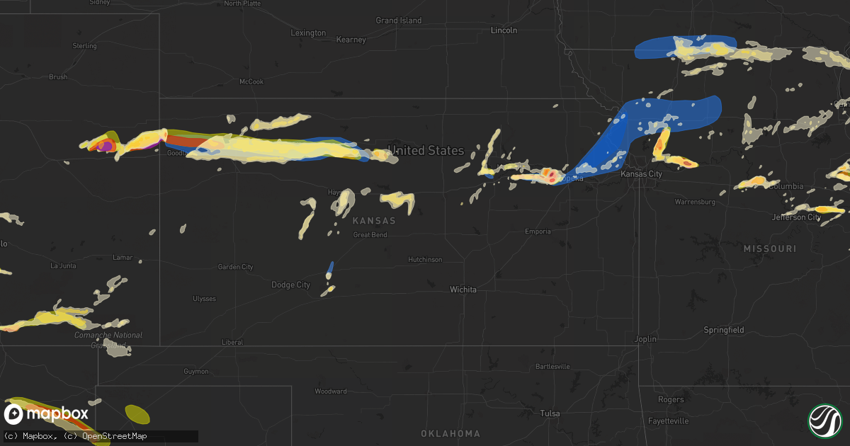
Hail Map in Kansas on June 30, 2023
Get this storm
June 30 map
$229
one time, instant access
Download today. No call, no setup
Keep the $229
Bought the map and want the full workflow? Apply the entire $229 to a subscription within 7 days. None of it is wasted.
Every map, not just this one
This buys you this map. Subscription and you get every map we run, in the markets you choose from a few cities to whole states to nationwide. Plus real-time alerts the moment a storm fires.
Contact data
Name, contact info, occupancy, even credit band for addresses in the footprint. You go from where it hit to who to call.
Become the source they trust
Unlimited branding weather history reports on demand. You already have the documented answer ready for the property owner, and you are the one who showed up with it.
Property data and RoofTrace estimates
Pull up any address you have got, its value and the exact code rules for that jurisdiction, straight from One Click Code. Then RoofTrace estimates the squares, pitch, and roof value, priced the way you price.
Storm reports in Kansas
Kansas
| Date | Description |
|---|---|
| 06/30/20236:58 PM CDT | The asos in hill city |
| 06/30/20236:57 PM CDT | Spotter reported quarter size hail 1 mile east of hill city. Time estimated via radar. |
| 06/30/20236:55 PM CDT | Spotter reported quarter size hail and estimated wind gusts up to 80 mph. |
| 06/30/20236:50 PM CDT | A local report indicates 1.00 inch wind near 7 S Manhattan |
| 06/30/20236:40 PM CDT | A local report indicates 1.00 inch wind near 3 WNW Manhattan |
| 06/30/20236:40 PM CDT | Social media report. |
| 06/30/20236:35 PM CDT | Facebook report of nickel to quarter size hail 13 miles northeast of hoxie. Time estimated via radar. |
| 06/30/20236:31 PM CDT | Public reported 50-60 mph wind gusts. |
| 06/30/20236:10 PM CDT | Large tree limb down. |
| 06/30/20236:10 PM CDT | Gas station employee estimated 60 mph wind gusts. |
| 06/30/20235:55 PM CDT | A local report indicates 1.25 inch wind near 5 SSE Milford |
| 06/30/20235:49 PM CDT | Mesonet station up841 1.9 w monument |
| 06/30/20235:45 PM CDT | A local report indicates 60 MPH wind near 5 SSE Milford |
| 06/30/20235:40 PM CDT | A local report indicates 1.00 inch wind near 4 S Wakefield |
| 06/30/20235:29 PM CDT | The awos in colby |
| 06/30/20235:25 PM CDT | Facebook report of quarter size hail 4 miles north of colby. Time estimated via radar. |
| 06/30/20235:25 PM CDT | The awos in colby |
| 06/30/20235:17 PM CDT | Report via facebook. |
| 06/30/20235:03 PM CDT | Lots of pea-sized hail as well. |
| 06/30/20234:41 PM CDT | Off-duty nws employee estimated 80 mph winds. |
| 06/30/20234:41 PM CDT | Off-duty nws employee followed-up to report broken windows associated with wind-driven hail. Additionally... A center pivot was blown over. Power out. |
| 06/30/20234:41 PM CDT | Received from facebook. |
| 06/30/20234:41 PM CDT | Reported via facebook. |
| 06/30/20234:41 PM CDT | Corrects previous hail report from 13 n edson. Hail up to 2 inches in diameter. |
| 06/30/20234:40 PM CDT | Powerline blown down from one of the electric poles. Estimated time of report. |
| 06/30/20234:38 PM CDT | A local report indicates 1.00 inch wind near 13 N Edson |
| 06/30/20234:38 PM CDT | Reported at least 60 mph with torrential rain. |
| 06/30/20234:27 PM CDT | Golf ball size hail on highway 27 about 10 miles north of goodland around 3:25 to 3:30 pm mdt. Time estimated via radar. Social media report with picture. |
| 06/30/20234:10 PM CDT | Lots of hail that has broken branches... Windows. |
| 06/29/20239:44 PM CDT | Reported from social media. |
| 06/29/20239:35 PM CDT | A local report indicates 60 MPH wind near 5 E Brookville |
| 06/29/20239:30 PM CDT | Caseys in atchison. |
| 06/29/20239:20 PM CDT | A local report indicates 59 MPH wind near 7 E Tipton |
| 06/29/20239:15 PM CDT | 235th and dempsey road east of mclouth ks. |
| 06/29/20239:05 PM CDT | Power lines down in nortonville. Time estimated by radar. |
| 06/29/20239:03 PM CDT | A local report indicates 1.00 inch wind near Oskaloosa |
| 06/29/20239:01 PM CDT | 14-16 inch tree limbs down. Time estimated radar. |
| 06/29/20239:00 PM CDT | Roof damage at jefferson north high school. Occurred on initial gust front. Time estimated from radar. |
| 06/29/20238:58 PM CDT | Multiple trees down throughout the town of oskaloosa. |
| 06/29/20238:58 PM CDT | 5 inch diameter li |
| 06/29/20238:58 PM CDT | 5 inch diameter limb fell on house. |
| 06/29/20238:57 PM CDT | Power lines down and a structure fire reported in the area. |
| 06/29/20238:53 PM CDT | Delayed report via social media. Images show sections of an outbuilding roof blown off. Time estimated via radar. |
| 06/29/20238:53 PM CDT | Spotter reported several large trees snapped 8 feet above the ground... And many large branches broken off. |
| 06/29/20238:52 PM CDT | Ongoing ping pong ball sized hail. |
| 06/29/20238:48 PM CDT | 10 to 12 inch tree branches down at 31st and k-4 highway. |
| 06/29/20238:48 PM CDT | Corrects previous tstm wnd |
| 06/29/20238:48 PM CDT | Corrects previous tstm wnd dmg report from 2 nw grantville. 32 inch diameter tree down at 31st and k-4 highway. |
| 06/29/20238:35 PM CDT | A local report indicates 60 MPH wind near 1 NNW Russell |
| 06/29/20238:35 PM CDT | Time estimated radar. |
| 06/29/20238:24 PM CDT | Asos station ktop topeka. |
| 06/29/20238:22 PM CDT | Multiple 4 to 8 inch diameter tree branches down near intersection of strait and seward. Time estimated from radar. |
| 06/29/20238:20 PM CDT | Report of at least 8 power poles blown over/snapped from the this evenings storm. |
| 06/29/20238:17 PM CDT | Two to three inch tree branch blown down. |
| 06/29/20238:12 PM CDT | A local report indicates 60 MPH wind near 4 WSW Topeka |
| 06/29/20238:08 PM CDT | 4-5 inch diameter limbs blown down. Estimated 70 to 75 mph winds. |
| 06/29/20238:02 PM CDT | A local report indicates 1.25 inch wind near 4 S Willard |
| 06/29/20237:57 PM CDT | A local report indicates 4.00 inch wind near 2 SSE Maple Hill |
| 06/29/20237:56 PM CDT | A local report indicates 1.50 inch wind near 2 NW Dover |
| 06/29/20237:56 PM CDT | A local report indicates 60 MPH wind near 2 NW Dover |
| 06/29/20237:45 PM CDT | Time estimated radar. Delayed report. |
| 06/29/20237:39 PM CDT | Report via facebook of golf ball size hail accompanied by 30 to 40 mph winds. |
| 06/29/20237:28 PM CDT | Camper overturned at webster lake. |
| 06/29/20237:25 PM CDT | Corrects previous hail report from 4 s stockton. Report via twitter of ping pong ball sized hail... Broken windows at this location. Time estimated from radar. |
| 06/29/20237:25 PM CDT | Report via twitter of ping pong ball sized hail. Time estimated from radar. |
| 06/29/20237:20 PM CDT | A local report indicates 1.50 inch wind near Mcfarland |
| 06/29/20237:20 PM CDT | A local report indicates 70 MPH wind near Mcfarland |
| 06/29/20237:14 PM CDT | Reported relayed via kake of some tree damage in damar. Time est from radar. |
| 06/29/20237:10 PM CDT | Spotter reported pea to quarter size hail. Time estimated via radar. |
| 06/29/20237:10 PM CDT | Spotter estimated 75 mph wind gusts. |
| 06/29/20237:02 PM CDT | The asos in hill city |
| 06/29/20237:00 PM CDT | Facebook report indicating that a semi with a load of cows was blown over on highway 283... Just south of town road q. Time estimated via radar. |
| 06/29/20237:00 PM CDT | Corrects previous tstm wnd dmg report from 5 n hill city. As of 8 pm mdt... Graham county emergency management reported up to 15 power poles blown over or snapped by hi |
All States Impacted by Hail Map on June 30, 2023
Cities Impacted by Hail Map on June 30, 2023
- Parnell, MO
- Blockton, IA
- Redding, IA
- Bedford, IA
- Benton, IA
- Sheridan, MO
- Lamoni, IA
- Eagleville, MO
- Davis City, IA
- Hatfield, MO
- Blythedale, MO
- Mercer, MO
- Kellerton, IA
- Cainsville, MO
- Mount Ayr, IA
- Grant City, MO
- Clio, IA
- Garden Grove, IA
- Decatur, IA
- Leon, IA
- Allerton, IA
- Grand River, IA
- Lineville, IA
- Corydon, IA
- Humeston, IA
- Seymour, IA
- Unionville, MO
- Powersville, MO
- Princeton, MO
- Sault Sainte Marie, MI
- Monterey, TN
- Crossville, TN
- Pattonsburg, MO
- Green Castle, MO
- Green City, MO
- Ridgeway, MO
- Gilman City, MO
- Gaylesville, AL
- Kahoka, MO
- Luray, MO
- Sedalia, CO
- Cedar Bluff, AL
- Hamilton, IL
- Basco, IL
- Elvaston, IL
- Warsaw, IL
- Keokuk, IA
- Carthage, IL
- Montrose, IA
- Pikeville, TN
- Argyle, IA
- Wayland, MO
- Newtown, MO
- Menlo, GA
- Brimley, MI
- Lucerne, MO
- Harris, MO
- Bethany, MO
- Plymouth, IL
- Farmington, IA
- Alexandria, MO
- Barbeau, MI
- Dafter, MI
- Kinross, MI
- Rising Fawn, GA
- Livonia, MO
- Queen City, MO
- Glenwood, MO
- Lancaster, MO
- Coatsville, MO
- McFall, MO
- Downing, MO
- Cincinnati, IA
- Arbela, MO
- Tennessee, IL
- Saint Patrick, MO
- Revere, MO
- Nauvoo, IL
- Memphis, MO
- Bloomfield, IA
- Exline, IA
- Centerville, IA
- Moulton, IA
- Pollock, MO
- Rockmart, GA
- Cantril, IA
- Mount Sterling, IA
- Eckerman, MI
- Hill City, SD
- Arriba, CO
- Flagler, CO
- Colorado Springs, CO
- Fountain, CO
- Seibert, CO
- Cope, CO
- Trinidad, CO
- Joes, CO
- Vona, CO
- Bethune, CO
- Stratton, CO
- Burlington, CO
- Rye, CO
- Pueblo, CO
- Strasburg, CO
- Idalia, CO
- Avondale, CO
- Saint Francis, KS
- Kanorado, KS
- Goodland, KS
- Levelland, TX
- Branson, CO
- Edson, KS
- Sturgis, KY
- Kim, CO
- Carbondale, IL
- Makanda, IL
- Brewster, KS
- Bird City, KS
- McDonald, KS
- Levant, KS
- Colby, KS
- Atwood, KS
- Carterville, IL
- Marion, IL
- Fort Stockton, TX
- Imperial, TX
- Mokane, MO
- Steedman, MO
- Chamois, MO
- Morrison, MO
- Hermann, MO
- Anton, TX
- Clarendon, TX
- Mclean, TX
- Shamrock, TX
- Energy, IL
- Herrin, IL
- Gem, KS
- Rexford, KS
- Johnston City, IL
- Glasgow, KY
- Cobden, IL
- Jonesboro, IL
- Anna, IL
- Dongola, IL
- Buncombe, IL
- Wakefield, KS
- Chapman, KS
- Junction City, KS
- Pacific, MO
- Hoxie, KS
- Selden, KS
- Pittsburg, IL
- Thompsonville, IL
- Milford, KS
- Kinsley, KS
- West Frankfort, IL
- Scobey, MT
- Bellvue, CO
- Boone, CO
- Union, MS
- Philadelphia, MS
- Aguilar, CO
- Halliday, ND
- Taylor, ND
- Gladstone, ND
- Brockton, MT
- Edgemont, SD
- Goreville, IL
- Smiths Grove, KY
- Froid, MT
- Kosciusko, MS
- Ethel, MS
- Madisonville, KY
- Nebo, KY
- Providence, KY
- Manitou, KY
- Wedowee, AL
- Wadley, AL
- Whitesburg, GA
- Carrollton, GA
- Centre, AL
- Dickinson, ND
- Manning, ND
- Littlefield, TX
- Millport, AL
- Whitetail, MT
- Tebbetts, MO
- Kermit, TX
- Wink, TX
- Hawks, MI
- Hillman, MI
- Lachine, MI
- Posen, MI
- Pritchett, CO
- Las Animas, CO
- Springfield, CO
- Labadie, MO
- Saint Albans, MO
- Villa Rica, GA
- Manchester, GA
- Temple, GA
- Bremen, GA
- Grantville, GA
- Hogansville, GA
- Lefor, ND
- Claude, TX
- Jennings, KS
- Oberlin, KS
- Dresden, KS
- Murphysboro, IL
- Uniontown, KY
- Jacksonville, AL
- Piedmont, AL
- Pine Ridge, SD
- Imperial, MO
- Greenville, GA
- Woodbury, GA
- Ozark, IL
- Creal Springs, IL
- Monahans, TX
- Marion, KY
- Panhandle, TX
- Warm Springs, GA
- Golden, CO
- Petersburg, TX
- Clay Center, KS
- Riley, KS
- Leonardville, KS
- Arnold, MO
- House Springs, MO
- Reserve, MT
- Newnan, GA
- Red Feather Lakes, CO
- Mott, ND
- Lewiston, MI
- Comins, MI
- Maxwell, NM
- Waverly, KY
- Morganfield, KY
- Clay, KY
- Barstow, TX
- Turner, MT
- Hugo, CO
- Bowling Green, VA
- Oglala, SD
- Lamar, CO
- Idalou, TX
- Anniston, AL
- Cedartown, GA
- Buchanan, GA
- Senoia, GA
- Moreland, GA
- Sharpsburg, GA
- Roanoke, AL
- Woodland, AL
- Muscadine, AL
- Fruithurst, AL
- Tallapoosa, GA
- Abilene, KS
- Columbus, MS
- Hamilton, MS
- Hogeland, MT
- Model, CO
- Hay Springs, NE
- Lorenzo, TX
- Princeton, KY
- Lagrange, GA
- Franklin, GA
- Meadow, TX
- Mount Vernon, IN
- Carthage, MS
- Estes Park, CO
- Alexander City, AL
- Jacksons Gap, AL
- Cave In Rock, IL
- Boncarbo, CO
- Amarillo, TX
- Canyon, TX
- Sulligent, AL
- Weston, CO
- Elizabethtown, IL
- Wolf Lake, IL
- Gardner, CO
- Happy, TX
- Coyanosa, TX
- Dadeville, AL
- Camp Hill, AL
- Caledonia, MS
- Wetmore, CO
- Saint Louis, MO
- Steens, MS
- Columbia, IL
- East Carondelet, IL
- Dupo, IL
- Vienna, IL
- Cypress, IL
- Dawson Springs, KY
- Manhattan, KS
- Eureka, MO
- Ballwin, MO
- Fenton, MO
- Valley Park, MO
- High Ridge, MO
- Lucas, KY
- Scottsville, KY
- Fountain Run, KY
- Austin, KY
- Etoile, KY
- Tompkinsville, KY
- Gamaliel, KY
- Morland, KS
- Penokee, KS
- Hill City, KS
- Wildwood, MO
- Waterloo, IL
- Valmeyer, IL
- Millstadt, IL
- Belleville, IL
- Smithton, IL
- Bogue, KS
- Stockton, KS
- Palco, KS
- Damar, KS
- Plainville, KS
- Kearney, MO
- Holt, MO
- Lawson, MO
- Alma, KS
- Kirwin, KS
- Glade, KS
- Saint Charles, KY
- Cerulean, KY
- Olmstead, KY
- Russellville, KY
- Freeburg, IL
- New Athens, IL
- Mascoutah, IL
- Tamaroa, IL
- Sesser, IL
- Lathrop, MO
- Polo, MO
- Excelsior Springs, MO
- Orrick, MO
- Richmond, MO
- Montgomery City, MO
- Wellsville, MO
- Middletown, MO
- Bellflower, MO
- Paxico, KS
- McFarland, KS
- Wamego, KS
- Maple Hill, KS
- De Soto, IL
- Freeman Spur, IL
- Woodston, KS
- Natoma, KS
- Alton, KS
- Osborne, KS
- Waldo, KS
- Royalton, IL
- Mulkeytown, IL
- Elkville, IL
- Zeigler, IL
- Orient, IL
- Christopher, IL
- Buckner, IL
- Benton, IL
- Adairville, KY
- Logan, IL
- Scheller, IL
- Waltonville, IL
- Turney, MO
- Topeka, KS
- Cameron, MO
- Kingston, MO
- Hardin, MO
- Henrietta, MO
- Lexington, MO
- Marissa, IL
- Lenzburg, IL
- Saint Libory, IL
- Addieville, IL
- Okawville, IL
- Oakdale, IL
- Nashville, IL
- Richview, IL
- Hoyleton, IL
- New Baden, IL
- Franklin, KY
- Harveyville, KS
- Macedonia, IL
- Dover, MO
- Norborne, MO
- Ralls, TX
- Crosbyton, TX
- Dickens, TX
- Spur, TX
- Rossville, KS
- Silver Lake, KS
- Hawk Point, MO
- Truxton, MO
- Silex, MO
- Du Bois, IL
- Ashley, IL
- Mount Vernon, IL
- Woodlawn, IL
- Opdyke, IL
- Lecompton, KS
- Grantville, KS
- Tecumseh, KS
- Meriden, KS
- Perry, KS
- Paradise, KS
- Coulterville, IL
- Pinckneyville, IL
- Ozawkie, KS
- Springfield, TN
- Orlinda, TN
- White House, TN
- Cross Plains, TN
- Cottontown, TN
- Gallatin, TN
- Hendersonville, TN
- Goodlettsville, TN
- Greenbrier, TN
- Whites Creek, TN
- Madison, TN
- Nashville, TN
- Old Hickory, TN
- Hermitage, TN
- Antioch, TN
- Smyrna, TN
- La Vergne, TN
- Mount Juliet, TN
- Lebanon, TN
- Nolensville, TN
- Portland, TN
- Tipton, KS
- Downs, KS
- Hunter, KS
- Troy, IL
- Oskaloosa, KS
- Nortonville, KS
- Valley Falls, KS
- Winchester, KS
- McLouth, KS
- Saint Jacob, IL
- Atchison, KS
- Tonganoxie, KS
- Easton, KS
- Leavenworth, KS
- Fort Leavenworth, KS
- Platte City, MO
- Weston, MO
- Cummings, KS
- Rushville, MO
- Readyville, TN
- Murfreesboro, TN
- Christiana, TN
- Arrington, TN
- Rockvale, TN
- College Grove, TN
- Eagleville, TN
- Franklin, TN
- Brentwood, TN
- Wayne City, IL
- Sims, IL
- Bluford, IL
- Belle Rive, IL
- Keenes, IL
- Dahlgren, IL
- Saint Ann, MO
- Lawrence, KS
- Lansing, KS
- Basehor, KS
- Gail, TX
- Fluvanna, TX
- Snyder, TX
- Ira, TX
- Hermleigh, TX
- Sweetwater, TX
- Loraine, TX
- Roscoe, TX
- Dearborn, MO
- De Kalb, MO
- Saint Joseph, MO
- Troy, KS
- Wathena, KS
- Faucett, MO
- Kansas City, KS
- Farley, MO
- Camden Point, MO
- Unionville, TN
- Bell Buckle, TN
- Chapel Hill, TN
- Shelbyville, TN
- Wartrace, TN
- Easton, MO
- Elwood, KS
- Agency, MO
- Clayton, NM
- Gladstone, NM
- Roy, NM
- Springer, NM
- Savannah, MO
- Amazonia, MO
- Cosby, MO
- Stewartsville, MO
- Gower, MO
- Clarksdale, MO
- Union Star, MO
- Helena, MO
- Liberty, MO
- Blackwater, MO
- Nelson, MO
- Pilot Grove, MO
- Mattoon, IL
- Franklin, MO
- New Franklin, MO
- Rea, MO
- Barnard, MO
- Bolckow, MO
- Conception Junction, MO
- Maryville, MO
- Guilford, MO
- Osborn, MO
- King City, MO
- Weatherby, MO
- Amity, MO
- Winston, MO
- Maysville, MO
- Altamont, MO
- Plattsburg, MO
- Gallatin, MO
- Kidder, MO
- Hamilton, MO
- Edgerton, MO
- Amistad, NM
- Waldron, IN
- Shelbyville, IN
- Hartsville, IN
- Hope, IN
- Greensburg, IN
- Lock Springs, MO
- Jamesport, MO
- Jameson, MO
- Braymer, MO
- Breckenridge, MO
- Chillicothe, MO
- Mooresville, MO
- Cowgill, MO
- Ludlow, MO
- Boonville, MO
- Trenton, MO
- Dawn, MO
- Utica, MO
- Nara Visa, NM
- Dalhart, TX
- Carson, ND
- Ellsworth, KS
- Merriman, NE
- Vandalia, MO
- Murdo, SD
- Elgin, ND
- Wentzville, MO
- Lake Saint Louis, MO
- Wood, SD
- Richardton, ND
- Crofton, KY
- Lena, MS
- Watford City, ND
- Holland, KY
- Killdeer, ND
- Collinsville, IL
- Glen Carbon, IL
- Granite City, IL
- Maryville, IL
- Morton, MS
- Pulaski, MS
- Rocheport, MO
- Columbia, MO
- Braxton, MS
- Florence, MS
- Camden, MO
- Indianapolis, IN
- Port Austin, MI
- Frohna, MO
- Smithville, TN
- Edwardsville, IL
- Marine, IL
- Floydada, TX
- Dodson, MT
- Troy, MO
- East Saint Louis, IL
- Vergennes, IL
- Eddyville, NE
- Sumner, NE
- Keene, ND
- Eskridge, KS
- Coatesville, IN
- Conehatta, MS
- Lawrence, MS
- Cambria, IL
- Clayton, KS
- Lenora, KS
- Norton, KS
- Almena, KS
- Norcatur, KS
- Brownell, KS
- Ellis, KS
- Post, TX
- Martinsburg, MO
- Warrenton, MO
- Maryland Heights, MO
- Seminole, TX
- Saint George, KS
- Welch, TX
- Boise City, OK
- Ashland City, TN
- White Bluff, TN
- Menoken, ND
- Sylvan Grove, KS
- Wilson, KS
- Lorraine, KS
- Kanopolis, KS
- Holyrood, KS
- Dorrance, KS
- Bunker Hill, KS
- Brownfield, TX
- Cave City, KY
- Horse Cave, KY
- Pleasant View, TN
- Ava, IL
- Gorham, IL
- Shawneetown, IL
- Junction, IL
- Arcadia, NE
- Andrews, TX
- Overton, NE
- Bazine, KS
- Ness City, KS
- Hope, KS
- Victoria, KS
- La Crosse, KS
- Bison, KS
- Hays, KS
- Nekoma, KS
- Pocahontas, IL
- Hickman, TN
- Liberty, TN
- Alexandria, TN
- Independence, MO
- Brush Creek, TN
- Carthage, TN
- Gordonsville, TN
- Riddleton, TN
- Goodwell, OK
- Walnut Grove, MS
- Fairfield, IL
- Golden Gate, IL
- Wellington, TX
- Saint Marys, KS
- Francisco, IN
- Petersburg, IN
- Charleston, IL
- Ashmore, IL
- Enterprise, KS
- Augusta, MO
- Defiance, MO
- Marthasville, MO
- Lafayette, TN
- Pelahatchie, MS
- Brandon, MS
- Whitleyville, TN
- Red Boiling Springs, TN
- Canute, OK
- Galatia, IL
- Carrier Mills, IL
- Pittsboro, NC
- Olsburg, KS
- Chesterfield, MO
- Saint Charles, MO
- Ina, IL
- Bonnie, IL
- Cunningham, TN
- Cumberland Furnace, TN
- Rayville, MO
- Chapmansboro, TN
- Denver City, TX
- Milford, VA
- Joelton, TN
- Carter, OK
- Granville, TN
- Buffalo Valley, TN
- Bloomington Springs, TN
- Curryville, MO
- Bowling Green, MO
- Pleasant Shade, TN
- Dixon Springs, TN
- Raleigh, IL
- Eldorado, IL
- Broughton, IL
- Highland, IL
- Slaughters, KY
- Hanson, KY
- Raleigh, MS
- Silver Point, TN
- Philpot, KY
- Johnsonville, IL
- Guymon, OK
- Albion, IL
- Du Quoin, IL
- Ridgway, IL
- Omaha, IL
- Baxter, TN
- Gracey, KY
- Caneyville, KY
- Brownsville, KY
- Leitchfield, KY
- Tahoka, TX
- Oakley, KS
- Barnes, KS
- Waterville, KS
- Randolph, KS
- Green, KS
- Offerle, KS
- Forest, MS
- Lake, MS
- Pomona, IL
- Plains, TX
- Larkspur, CO
- Elbert, CO
- Pegram, TN
- Rush Center, KS
- Liebenthal, KS
- McCracken, KS
- Walker, KS
- Gorham, KS
- Otis, KS
- Schoenchen, KS
- Russell, KS
- Pfeifer, KS
- Alta Vista, KS
- Dwight, KS
- Grand Tower, IL
- Alvaton, KY
- Adolphus, KY
- Chapel Hill, NC
- Moncure, NC
- New Bloomfield, MO
- Mendenhall, MS
- Trenton, IL
- Southside, TN
- Hurst, IL
- Palmyra, TN
- Winner, SD
- Crawfordsville, IN
- Campo, CO
- Kenton, OK
- Sheridan Lake, CO
- Ropesville, TX
- Beulah, ND
- Paris, IL
- Kansas, IL
- Gypsum, KS
- Hopkinsville, KY
- Equality, IL
- Earlington, KY
- Nortonville, KY
- Lucas, KS
- Beloit, KS
- Ransom, KS
- Wakeeney, KS
- Portis, KS
- Keyes, OK
- Florissant, CO
- Cripple Creek, CO
- White River, SD
- Harrisburg, IL
- Greenwood, IN
- Dixon, KY
- Guffey, CO
- Granada, CO
- Kingston Springs, TN
- Park City, KY
- Bowling Green, KY
- Allensville, KY
- Cedar Hill, TN
- Charlotte, TN
- Westmoreland, TN
- Gainesboro, TN
- Washington, MO
- Roxie, MS
- Lovejoy, IL
- Venice, IL
- Madison, IL
- Gray Summit, MO
- Caseyville, IL
- Dowell, IL
- Lebanon, IL
- O'Fallon, IL
- Foristell, MO
- Tribune, KS
- Fillmore, IN
- Greencastle, IN
- Justiceburg, TX
- Belvue, KS
- Rinard, IL
- Westport, IN
- North Vernon, IN
- Versailles, IN
- Cross Plains, IN
- Dillsboro, IN
- Bennington, IN
- Stratford, TX
- West Terre Haute, IN
- Vermilion, IL
- Clinton, IN
- Universal, IN
- Rosedale, IN
- New Goshen, IN
- Terre Haute, IN
- Laredo, MO
- Chula, MO
- Humphreys, MO
- Wheeling, MO
- Meadville, MO
- Rising Sun, IN
- Patriot, IN
- Vevay, IN
- Florence, IN
- Staunton, IN
- Knightsville, IN
- Harmony, IN
- Brazil, IN
- Centerpoint, IN
- Reelsville, IN
- Poland, IN
- Cloverdale, IN
- Spencer, IN
- Glencoe, KY
- Sparta, KY
- Warsaw, KY
- Quincy, IN
- Gosport, IN
- Dry Ridge, KY
- Jonesville, KY
- Centralia, IL
- Alma, IL
- Annapolis, IL
- Bartelso, IL
- Newton, IL
- Carlyle, IL
- Louisville, IL
- Oblong, IL
- West York, IL
- Hutsonville, IL
- Farina, IL
- Hoffman, IL
- Salem, IL
- Willow Hill, IL
- Kinmundy, IL
- Dieterich, IL
- Odin, IL
- Sandoval, IL
- Xenia, IL
- Evansville, IN
- Chandler, IN
- Boonville, IN
- Elberfeld, IN
- Newburgh, IN
- Chrisney, IN
- Tennyson, IN
- Richland, IN
- Rockport, IN
- Grandview, IN
- Masterson, TX
- Vega, TX
- Sabetha, KS
- Oneida, KS
- Louisiana, MO
- Pleasant Hill, IL
- Shelbina, MO
- Shelbyville, MO
- Valley Head, AL
- Osgood, IN
- Girard, IL
- Salisbury, MO
- Raymond, IL
- Winchester, KY
- Paris, KY
- Slater, MO
- Corinth, KY
- Cynthiana, KY
- Williamstown, KY
- Carlisle, KY
- Berry, KY
- Windsor, IL
- Milan, IN
- Scottsburg, IN
- Deputy, IN
- Austin, IN
- Hull, IL
- Hannibal, MO
- Virden, IL
- Texline, TX
- Tina, MO
- Hale, MO
- Breese, IL
- Bainbridge, IN
- Bogard, MO
- Rockport, IL
- Bowling Green, IN
- Cairo, MO
- Jacksonville, MO
- Carbon, IN
- Ethel, MO
- New Boston, MO
- Madison, IN
- Owenton, KY
- Maceo, KY
- Owensboro, KY
- New Florence, MO
- Waverly, IL
- Mount Sterling, KY
- Bremen, KY
- Fayette, MO
- Pittsfield, IL
- Harvel, IL
- Mosquero, NM
- Monroe City, MO
- Lancaster, KS
- Murrayville, IL
- Roodhouse, IL
- Westfield, IL
- Lynnville, IN
- Keytesville, MO
- Lyerly, GA
- Nebo, IL
- Robinson, IL
- Lewisport, KY
- Sacramento, KY
- Island, KY
- Geff, IL
- Cisne, IL
- Palmyra, IL
- Holton, IN
- Butlerville, IN
- Flat Rock, IN
- Edinburgh, IN
- Central City, KY
- Mendon, MO
- Marceline, MO
- Lebanon, IN
- Jamestown, IN
- Pearl, IL
- Hillview, IL
- Canaan, IN
- Moores Hill, IN
- Aurora, IN
- Freetown, IN
- Franklin, IL
- Greensburg, KS
- Stilesville, IN
- Clayton, IN
- Winchester, IL
- Trilla, IL
- Neoga, IL
- Bargersville, IN
- Franklin, IN
- Auburn, IL
- Excello, MO
- Macon, MO
- Bevier, MO
- Richmond, KY
- Beech Grove, IN
- Bloomington, IN
- Marshall, MO
- Hughesville, MO
- Rockville, IN
- Mortons Gap, KY
- Calhoun, KY
- Rumsey, KY
- Milroy, IN
- Saint Paul, IN
- Henderson, KY
- Stamping Ground, KY
- Frankfort, KY
- Reynolds Station, KY
- Palmyra, MO
- Huntsville, MO
- Dalton City, IL
- Milton, KY
- Poseyville, IN
- Bedford, KY
- Pendleton, KY
- Needham, IN
- Whiteland, IN
- Boggstown, IN
- Ghent, KY
- Martinsville, IN
- Mooresville, IN
- Fairland, IN
- Meredosia, IL
- Chapin, IL
- Arenzville, IL
- Hanover, IN
- Nabb, IN
- Mullinville, KS
- White Hall, IL
- Greenfield, IL
- Carrollton, IL
- Marshall, IL
- Lerna, IL
- Toledo, IL
- Greenup, IL
- Morrisonville, IL
- Farmersville, IL
- Pawnee, IL
- Concord, IL
- Bendena, KS
- Kell, IL
- Iuka, IL
- Nashville, IN
- Livermore, KY
- Hartford, KY
- Columbus, IN
- Lexington, IN
- Bucklin, MO
- Nokomis, IL
- Rotan, TX
- Quincy, IL
- Taylor, MO
- Avon, IN
- Shipman, IL
- Virginia, IL
- Ellery, IL
- Hollywood, AL
- Dennison, IL
- Timewell, IL
- Hunnewell, MO
- Linn, MO
- Fort Branch, IN
- Haubstadt, IN
- Browns, IL
- Griffin, IN
- Wadesville, IN
- Owensville, IN
- Cynthiana, IN
- Hawesville, KY
- New Harmony, IN
- Fordsville, KY
- Grayville, IL
- Sadieville, KY
- La Monte, MO
- Houstonia, MO
- Paris, MO
- Camp Point, IL
- Rhineland, MO
- Waggoner, IL
- Emden, MO
- Philadelphia, MO
- Fort Riley, KS
- Callao, MO
- Palmer, IL
- Taylorville, IL
- Commiskey, IN
- Wrights, IL
- Seymour, IN
- Palestine, IL
- Carrollton, MO
- Putnamville, IN
- Clarence, MO
- Longford, KS
- Minneapolis, KS
- Payson, IL
- Strasburg, IL
- Gays, IL
- Carlinville, IL
- Brookfield, MO
- Rothville, MO
- New Cambria, MO
- Dalton, MO
- Casey, IL
- Verona, KY
- Summerfield, IL
- Alhambra, IL
- Beckemeyer, IL
- Aviston, IL
- Germantown, IL
- Fairview Heights, IL
- New Douglas, IL
- Modesto, IL
- Union, MO
- Clayton, IL
- Gillespie, IL
- Beardstown, IL
- Bonnots Mill, MO
- Brusett, MT
- West Salem, IL
- Le Roy, IL
- Linton, IN
- Lyons, IN
- Sandborn, IN
- Lentner, MO
- Anabel, MO
- Madison, MO
- Cuba, MO
- Sullivan, MO
- Bourbon, MO
- Maywood, MO
- Edina, MO
- Bethany, IL
- Moweaqua, IL
- Flat Rock, IL
- Carlisle, IN
- Merom, IN
- Sullivan, IN
- Waynesville, IL
- Beason, IL
- Atlanta, IL
- Clinton, IL
- Eolia, MO
- Pekin, IN
- Portland, MO
- West Union, IL
- Martinsville, IL
- Bunker Hill, IL
- Irvine, KY
- Jenkins, KY
- Pound, VA
- Wise, VA
- Mayking, KY
- Whitesburg, KY
- Holts Summit, MO
- Versailles, IL
- Ashland, MO
- Hartsburg, MO
- Sigel, IL
- Effingham, IL
- Williamsburg, MO
- Salem, IN
- Teutopolis, IL
- High Hill, MO
- Jonesburg, MO
- Bethalto, IL
- Alton, IL
- Borden, IN
- Berger, MO
- Arthur, IL
- Sullivan, IL
- Brownstown, IN
- Montrose, IL
- Stoy, IL
- Mount Erie, IL
- Cedar Hill, MO
- Fulton, MO
- Jefferson City, MO
- Mitchell, IN
- Shoals, IN
- East Alton, IL
- Wood River, IL
- Nineveh, IN
- Wheeler, IL
- Moro, IL
- Oaktown, IN
- Novelty, MO
- Jeffersonville, KY
- Butler, IL
- Litchfield, IL
- Old Monroe, MO
- Moscow Mills, MO
- O'Fallon, MO
- Rosebud, MO
- Bridgeton, MO
- Saint Peters, MO
- Florissant, MO
- Hazelwood, MO
- Hettick, IL
- Wright City, MO
- Truesdale, MO
- Hurdland, MO
- Decatur, MS
- Garner, KY
- Leburn, KY
- Hindman, KY
- Mousie, KY
- Lovington, IL
- Noble, IL
- Beaufort, MO
- Leslie, MO
- Dittmer, MO
- Griggsville, IL
- Centertown, MO
- Owensville, MO
- Gerald, MO
- New Salem, IL
- New Haven, MO
- Clay City, KY
- Stanton, KY
- Mallie, KY
- Thornton, KY
- Ermine, KY
- Pine Top, KY
- Millstone, KY
- Deane, KY
- Villa Ridge, MO
- Findlay, IL
- Edwardsport, IN
- Westphalia, IN
- Flora, IL


