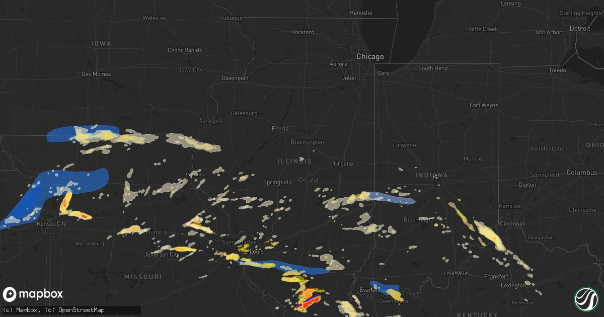
Hail Map in Illinois on June 30, 2023
Get this storm
June 30 map
$229
one time, instant access
Download today. No call, no setup
Keep the $229
Bought the map and want the full workflow? Apply the entire $229 to a subscription within 7 days. None of it is wasted.
Every map, not just this one
This buys you this map. Subscription and you get every map we run, in the markets you choose from a few cities to whole states to nationwide. Plus real-time alerts the moment a storm fires.
Contact data
Name, contact info, occupancy, even credit band for addresses in the footprint. You go from where it hit to who to call.
Become the source they trust
Unlimited branding weather history reports on demand. You already have the documented answer ready for the property owner, and you are the one who showed up with it.
Property data and RoofTrace estimates
Pull up any address you have got, its value and the exact code rules for that jurisdiction, straight from One Click Code. Then RoofTrace estimates the squares, pitch, and roof value, priced the way you price.
Storm reports in Illinois
Illinois
| Date | Description |
|---|---|
| 06/30/20236:56 PM CDT | Estimated 60 mph winds and nickel sized hail. |
| 06/30/20236:56 PM CDT | Trees and power lines down at the intersection of st. Paul street and gardner street. |
| 06/30/20236:55 PM CDT | Lots of mature trees blown down onto bohleysville road south southwest of millstadt. Via facebook. |
| 06/30/20236:49 PM CDT | Corrects previous tstm wnd dmg report from 2 se columbia. Large tree blown over. Limbs blocking illinois route 3. |
| 06/30/20236:46 PM CDT | Corrects previous tstm wnd dmg report from 1 se columbia. Trees and power lines down at the intersection of st. Paul street and gardner street. |
| 06/30/20236:31 PM CDT | A local report indicates 1.00 inch wind near 1 SE West Frankfort |
| 06/30/20236:31 PM CDT | A local report indicates 1.25 inch wind near West Frankfort |
| 06/30/20236:05 PM CDT | A local report indicates 1.00 inch wind near Cypress |
| 06/30/20236:03 PM CDT | A local report indicates 1.75 inch wind near 3 SSE Buncombe |
| 06/30/20235:54 PM CDT | Damaged caused by baseball sized hail. |
| 06/30/20235:44 PM CDT | A local report indicates 2.75 inch wind near 1 N Pittsburg |
| 06/30/20235:40 PM CDT | A local report indicates 1.75 inch wind near 1 SE Carbondale |
| 06/30/20235:37 PM CDT | Report from mping: quarter |
| 06/30/20235:35 PM CDT | A local report indicates 2.75 inch wind near Johnston City |
| 06/30/20235:35 PM CDT | Corrects previous hail report from johnston city. Public has dents to car and cracked windshield. |
| 06/30/20235:34 PM CDT | Report from mping: quarter |
| 06/30/20235:31 PM CDT | A local report indicates 1.50 inch wind near 1 NE Marion |
| 06/30/20235:30 PM CDT | Major damage to multiple vehicles at car dealership. |
| 06/30/20235:28 PM CDT | Airplane at airport has busted windows. |
| 06/30/20235:27 PM CDT | A local report indicates 1.00 inch wind near 1 ENE Marion |
| 06/30/20235:25 PM CDT | A local report indicates 1.50 inch wind near Anna |
| 06/30/20235:25 PM CDT | Report from mping: golf ball |
| 06/30/20235:24 PM CDT | Damage to the ballpark. |
| 06/30/20235:24 PM CDT | Numerous damaged vehicles from golf ball sized hail. |
| 06/30/20235:22 PM CDT | A local report indicates 1.75 inch wind near 2 ESE Crainville |
| 06/30/20235:21 PM CDT | A local report indicates 1.00 inch wind near 1 SE Crainville |
| 06/30/20235:20 PM CDT | A local report indicates 1.75 inch wind near Anna |
| 06/30/20235:20 PM CDT | A local report indicates 3.00 inch wind near 2 S Energy |
| 06/30/20235:19 PM CDT | Report from mping: quarter |
| 06/30/20235:01 PM CDT | Corrects previous hail report from 3 nne makanda. |
| 06/30/20235:00 PM CDT | A local report indicates 1.75 inch wind near 5 NE Makanda |
| 06/30/20234:52 PM CDT | A local report indicates 1.25 inch wind near 3 NNE Makanda |
| 06/30/20237:34 AM CDT | Widespread tree damage around town. Numerous large trees blown down as well as tree limbs and power lines. Via pictures on facebook. |
| 06/30/20233:38 AM CDT | Report from mping: 3-inch tree limbs broken; power poles broken. |
| 06/30/20233:05 AM CDT | Report from mping: 3-inch tree limbs broken; power poles broken. |
| 06/30/20233:00 AM CDT | Public estimated 60 mph winds. |
| 06/30/20232:30 AM CDT | Multiple reports of trees and limbs down around quincy. Time estimated from radar. |
| 06/29/202310:50 PM CDT | Report of varying hail sizes ranging from pea... Dime... And nickel. A few measured in at 1 inch. |
| 06/29/202310:06 PM CDT | Report from mping: trees uprooted or snapped; roof blown off. |
| 06/29/20239:56 PM CDT | Report from mping: 3-inch tree limbs broken; power poles broken. |
| 06/29/20239:49 PM CDT | Report from mping: quarter |
| 06/29/20239:40 PM CDT | Multiple tree limbs 6 inches in diameter down along sheridan ave. One tree 14 inches in diameter down in an alley way behind sheridan ave. Time estimated by radar. |
| 06/29/20239:30 PM CDT | Report from mping: 3-inch tree limbs broken; power poles broken. |
| 06/29/20238:56 PM CDT | Reports of power lines down on golf course rd and n west st. |
| 06/29/20238:53 PM CDT | Large tree down on state route 142 and county road 200 e. |
| 06/29/20238:48 PM CDT | Report from mping: quarter |
| 06/29/20238:43 PM CDT | A local report indicates 70 MPH wind near 1 WSW Mount Vernon |
| 06/29/20238:30 PM CDT | Tree fell on a mobile home and damaged the home. Large maple tree snapped as well. |
| 06/29/20238:30 PM CDT | A local report indicates 1.25 inch wind near 4 SE Troy |
| 06/29/20238:30 PM CDT | A local report indicates 1.75 inch wind near 4 W Tamaroa |
| 06/29/20238:25 PM CDT | Multiple trees and powerlines down. |
| 06/29/20238:10 PM CDT | Widespread wind damage around town. Numerous large trees blown down... One fell onto a house. Also... A number of trees blown down onto illinois route 15. Lots of tree |
| 06/29/20237:57 PM CDT | Large tree down. |
| 06/29/20237:54 PM CDT | Barn and machine shed destroyed. |
| 06/29/20237:53 PM CDT | Wind damage reported throughout the town of nashville... Il by the county emergency manager. |
| 06/29/20237:47 PM CDT | Report from mping: trees uprooted or snapped; roof blown off. |
| 06/29/20237:45 PM CDT | Report from mping: 3-inch tree limbs broken; power poles broken. |
| 06/29/20237:42 PM CDT | Heavily-damaged outbuildings and barns. |
| 06/29/20237:37 PM CDT | 4 tree limbs down. |
| 06/29/20237:37 PM CDT | Multiple large treetops blown off. |
| 06/29/20237:36 PM CDT | Report from mping: quarter |
| 06/29/20237:34 PM CDT | Corrects previous tstm wnd dmg report from venedy. Widespread tree damage around town. Numerous large trees blown down as well as tree limbs and power lines. Via pictur |
| 06/29/20237:31 PM CDT | Significant tree damage in st. Libory. Home sustained damage to the roof and several limbs snapped. |
| 06/29/20237:20 PM CDT | 8 ft diameter tree blown over. |
| 06/29/20237:16 PM CDT | Em at the freeburg ema office reported wind gust and power outage. |
| 06/29/20237:13 PM CDT | Corrects previous hail report from 2 sse benton. |
| 06/29/20237:13 PM CDT | A local report indicates 1.75 inch wind near 2 SSE Benton |
| 06/29/20237:11 PM CDT | Damage city wide. Power poles blown down and top of silo blown off. Various size limbs all over roads. |
| 06/29/20237:05 PM CDT | Tree down in smithton... Il. Picture via twitter. |
| 06/29/20237:04 PM CDT | Large tree blown over. Limbs blocking hwy 3. |
| 06/29/20237:02 PM CDT | Corrects previous hail report from 1 ssw mcleansboro. |
| 06/29/20237:02 PM CDT | A local report indicates 1.00 inch wind near 1 SSW Mcleansboro |
All States Impacted by Hail Map on June 30, 2023
Cities Impacted by Hail Map on June 30, 2023
- Parnell, MO
- Blockton, IA
- Redding, IA
- Bedford, IA
- Benton, IA
- Sheridan, MO
- Lamoni, IA
- Eagleville, MO
- Davis City, IA
- Hatfield, MO
- Blythedale, MO
- Mercer, MO
- Kellerton, IA
- Cainsville, MO
- Mount Ayr, IA
- Grant City, MO
- Clio, IA
- Garden Grove, IA
- Decatur, IA
- Leon, IA
- Allerton, IA
- Grand River, IA
- Lineville, IA
- Corydon, IA
- Humeston, IA
- Seymour, IA
- Unionville, MO
- Powersville, MO
- Princeton, MO
- Sault Sainte Marie, MI
- Monterey, TN
- Crossville, TN
- Pattonsburg, MO
- Green Castle, MO
- Green City, MO
- Ridgeway, MO
- Gilman City, MO
- Gaylesville, AL
- Kahoka, MO
- Luray, MO
- Sedalia, CO
- Cedar Bluff, AL
- Hamilton, IL
- Basco, IL
- Elvaston, IL
- Warsaw, IL
- Keokuk, IA
- Carthage, IL
- Montrose, IA
- Pikeville, TN
- Argyle, IA
- Wayland, MO
- Newtown, MO
- Menlo, GA
- Brimley, MI
- Lucerne, MO
- Harris, MO
- Bethany, MO
- Plymouth, IL
- Farmington, IA
- Alexandria, MO
- Barbeau, MI
- Dafter, MI
- Kinross, MI
- Rising Fawn, GA
- Livonia, MO
- Queen City, MO
- Glenwood, MO
- Lancaster, MO
- Coatsville, MO
- McFall, MO
- Downing, MO
- Cincinnati, IA
- Arbela, MO
- Tennessee, IL
- Saint Patrick, MO
- Revere, MO
- Nauvoo, IL
- Memphis, MO
- Bloomfield, IA
- Exline, IA
- Centerville, IA
- Moulton, IA
- Pollock, MO
- Rockmart, GA
- Cantril, IA
- Mount Sterling, IA
- Eckerman, MI
- Hill City, SD
- Arriba, CO
- Flagler, CO
- Colorado Springs, CO
- Fountain, CO
- Seibert, CO
- Cope, CO
- Trinidad, CO
- Joes, CO
- Vona, CO
- Bethune, CO
- Stratton, CO
- Burlington, CO
- Rye, CO
- Pueblo, CO
- Strasburg, CO
- Idalia, CO
- Avondale, CO
- Saint Francis, KS
- Kanorado, KS
- Goodland, KS
- Levelland, TX
- Branson, CO
- Edson, KS
- Sturgis, KY
- Kim, CO
- Carbondale, IL
- Makanda, IL
- Brewster, KS
- Bird City, KS
- McDonald, KS
- Levant, KS
- Colby, KS
- Atwood, KS
- Carterville, IL
- Marion, IL
- Fort Stockton, TX
- Imperial, TX
- Mokane, MO
- Steedman, MO
- Chamois, MO
- Morrison, MO
- Hermann, MO
- Anton, TX
- Clarendon, TX
- Mclean, TX
- Shamrock, TX
- Energy, IL
- Herrin, IL
- Gem, KS
- Rexford, KS
- Johnston City, IL
- Glasgow, KY
- Cobden, IL
- Jonesboro, IL
- Anna, IL
- Dongola, IL
- Buncombe, IL
- Wakefield, KS
- Chapman, KS
- Junction City, KS
- Pacific, MO
- Hoxie, KS
- Selden, KS
- Pittsburg, IL
- Thompsonville, IL
- Milford, KS
- Kinsley, KS
- West Frankfort, IL
- Scobey, MT
- Bellvue, CO
- Boone, CO
- Union, MS
- Philadelphia, MS
- Aguilar, CO
- Halliday, ND
- Taylor, ND
- Gladstone, ND
- Brockton, MT
- Edgemont, SD
- Goreville, IL
- Smiths Grove, KY
- Froid, MT
- Kosciusko, MS
- Ethel, MS
- Madisonville, KY
- Nebo, KY
- Providence, KY
- Manitou, KY
- Wedowee, AL
- Wadley, AL
- Whitesburg, GA
- Carrollton, GA
- Centre, AL
- Dickinson, ND
- Manning, ND
- Littlefield, TX
- Millport, AL
- Whitetail, MT
- Tebbetts, MO
- Kermit, TX
- Wink, TX
- Hawks, MI
- Hillman, MI
- Lachine, MI
- Posen, MI
- Pritchett, CO
- Las Animas, CO
- Springfield, CO
- Labadie, MO
- Saint Albans, MO
- Villa Rica, GA
- Manchester, GA
- Temple, GA
- Bremen, GA
- Grantville, GA
- Hogansville, GA
- Lefor, ND
- Claude, TX
- Jennings, KS
- Oberlin, KS
- Dresden, KS
- Murphysboro, IL
- Uniontown, KY
- Jacksonville, AL
- Piedmont, AL
- Pine Ridge, SD
- Imperial, MO
- Greenville, GA
- Woodbury, GA
- Ozark, IL
- Creal Springs, IL
- Monahans, TX
- Marion, KY
- Panhandle, TX
- Warm Springs, GA
- Golden, CO
- Petersburg, TX
- Clay Center, KS
- Riley, KS
- Leonardville, KS
- Arnold, MO
- House Springs, MO
- Reserve, MT
- Newnan, GA
- Red Feather Lakes, CO
- Mott, ND
- Lewiston, MI
- Comins, MI
- Maxwell, NM
- Waverly, KY
- Morganfield, KY
- Clay, KY
- Barstow, TX
- Turner, MT
- Hugo, CO
- Bowling Green, VA
- Oglala, SD
- Lamar, CO
- Idalou, TX
- Anniston, AL
- Cedartown, GA
- Buchanan, GA
- Senoia, GA
- Moreland, GA
- Sharpsburg, GA
- Roanoke, AL
- Woodland, AL
- Muscadine, AL
- Fruithurst, AL
- Tallapoosa, GA
- Abilene, KS
- Columbus, MS
- Hamilton, MS
- Hogeland, MT
- Model, CO
- Hay Springs, NE
- Lorenzo, TX
- Princeton, KY
- Lagrange, GA
- Franklin, GA
- Meadow, TX
- Mount Vernon, IN
- Carthage, MS
- Estes Park, CO
- Alexander City, AL
- Jacksons Gap, AL
- Cave In Rock, IL
- Boncarbo, CO
- Amarillo, TX
- Canyon, TX
- Sulligent, AL
- Weston, CO
- Elizabethtown, IL
- Wolf Lake, IL
- Gardner, CO
- Happy, TX
- Coyanosa, TX
- Dadeville, AL
- Camp Hill, AL
- Caledonia, MS
- Wetmore, CO
- Saint Louis, MO
- Steens, MS
- Columbia, IL
- East Carondelet, IL
- Dupo, IL
- Vienna, IL
- Cypress, IL
- Dawson Springs, KY
- Manhattan, KS
- Eureka, MO
- Ballwin, MO
- Fenton, MO
- Valley Park, MO
- High Ridge, MO
- Lucas, KY
- Scottsville, KY
- Fountain Run, KY
- Austin, KY
- Etoile, KY
- Tompkinsville, KY
- Gamaliel, KY
- Morland, KS
- Penokee, KS
- Hill City, KS
- Wildwood, MO
- Waterloo, IL
- Valmeyer, IL
- Millstadt, IL
- Belleville, IL
- Smithton, IL
- Bogue, KS
- Stockton, KS
- Palco, KS
- Damar, KS
- Plainville, KS
- Kearney, MO
- Holt, MO
- Lawson, MO
- Alma, KS
- Kirwin, KS
- Glade, KS
- Saint Charles, KY
- Cerulean, KY
- Olmstead, KY
- Russellville, KY
- Freeburg, IL
- New Athens, IL
- Mascoutah, IL
- Tamaroa, IL
- Sesser, IL
- Lathrop, MO
- Polo, MO
- Excelsior Springs, MO
- Orrick, MO
- Richmond, MO
- Montgomery City, MO
- Wellsville, MO
- Middletown, MO
- Bellflower, MO
- Paxico, KS
- McFarland, KS
- Wamego, KS
- Maple Hill, KS
- De Soto, IL
- Freeman Spur, IL
- Woodston, KS
- Natoma, KS
- Alton, KS
- Osborne, KS
- Waldo, KS
- Royalton, IL
- Mulkeytown, IL
- Elkville, IL
- Zeigler, IL
- Orient, IL
- Christopher, IL
- Buckner, IL
- Benton, IL
- Adairville, KY
- Logan, IL
- Scheller, IL
- Waltonville, IL
- Turney, MO
- Topeka, KS
- Cameron, MO
- Kingston, MO
- Hardin, MO
- Henrietta, MO
- Lexington, MO
- Marissa, IL
- Lenzburg, IL
- Saint Libory, IL
- Addieville, IL
- Okawville, IL
- Oakdale, IL
- Nashville, IL
- Richview, IL
- Hoyleton, IL
- New Baden, IL
- Franklin, KY
- Harveyville, KS
- Macedonia, IL
- Dover, MO
- Norborne, MO
- Ralls, TX
- Crosbyton, TX
- Dickens, TX
- Spur, TX
- Rossville, KS
- Silver Lake, KS
- Hawk Point, MO
- Truxton, MO
- Silex, MO
- Du Bois, IL
- Ashley, IL
- Mount Vernon, IL
- Woodlawn, IL
- Opdyke, IL
- Lecompton, KS
- Grantville, KS
- Tecumseh, KS
- Meriden, KS
- Perry, KS
- Paradise, KS
- Coulterville, IL
- Pinckneyville, IL
- Ozawkie, KS
- Springfield, TN
- Orlinda, TN
- White House, TN
- Cross Plains, TN
- Cottontown, TN
- Gallatin, TN
- Hendersonville, TN
- Goodlettsville, TN
- Greenbrier, TN
- Whites Creek, TN
- Madison, TN
- Nashville, TN
- Old Hickory, TN
- Hermitage, TN
- Antioch, TN
- Smyrna, TN
- La Vergne, TN
- Mount Juliet, TN
- Lebanon, TN
- Nolensville, TN
- Portland, TN
- Tipton, KS
- Downs, KS
- Hunter, KS
- Troy, IL
- Oskaloosa, KS
- Nortonville, KS
- Valley Falls, KS
- Winchester, KS
- McLouth, KS
- Saint Jacob, IL
- Atchison, KS
- Tonganoxie, KS
- Easton, KS
- Leavenworth, KS
- Fort Leavenworth, KS
- Platte City, MO
- Weston, MO
- Cummings, KS
- Rushville, MO
- Readyville, TN
- Murfreesboro, TN
- Christiana, TN
- Arrington, TN
- Rockvale, TN
- College Grove, TN
- Eagleville, TN
- Franklin, TN
- Brentwood, TN
- Wayne City, IL
- Sims, IL
- Bluford, IL
- Belle Rive, IL
- Keenes, IL
- Dahlgren, IL
- Saint Ann, MO
- Lawrence, KS
- Lansing, KS
- Basehor, KS
- Gail, TX
- Fluvanna, TX
- Snyder, TX
- Ira, TX
- Hermleigh, TX
- Sweetwater, TX
- Loraine, TX
- Roscoe, TX
- Dearborn, MO
- De Kalb, MO
- Saint Joseph, MO
- Troy, KS
- Wathena, KS
- Faucett, MO
- Kansas City, KS
- Farley, MO
- Camden Point, MO
- Unionville, TN
- Bell Buckle, TN
- Chapel Hill, TN
- Shelbyville, TN
- Wartrace, TN
- Easton, MO
- Elwood, KS
- Agency, MO
- Clayton, NM
- Gladstone, NM
- Roy, NM
- Springer, NM
- Savannah, MO
- Amazonia, MO
- Cosby, MO
- Stewartsville, MO
- Gower, MO
- Clarksdale, MO
- Union Star, MO
- Helena, MO
- Liberty, MO
- Blackwater, MO
- Nelson, MO
- Pilot Grove, MO
- Mattoon, IL
- Franklin, MO
- New Franklin, MO
- Rea, MO
- Barnard, MO
- Bolckow, MO
- Conception Junction, MO
- Maryville, MO
- Guilford, MO
- Osborn, MO
- King City, MO
- Weatherby, MO
- Amity, MO
- Winston, MO
- Maysville, MO
- Altamont, MO
- Plattsburg, MO
- Gallatin, MO
- Kidder, MO
- Hamilton, MO
- Edgerton, MO
- Amistad, NM
- Waldron, IN
- Shelbyville, IN
- Hartsville, IN
- Hope, IN
- Greensburg, IN
- Lock Springs, MO
- Jamesport, MO
- Jameson, MO
- Braymer, MO
- Breckenridge, MO
- Chillicothe, MO
- Mooresville, MO
- Cowgill, MO
- Ludlow, MO
- Boonville, MO
- Trenton, MO
- Dawn, MO
- Utica, MO
- Nara Visa, NM
- Dalhart, TX
- Carson, ND
- Ellsworth, KS
- Merriman, NE
- Vandalia, MO
- Murdo, SD
- Elgin, ND
- Wentzville, MO
- Lake Saint Louis, MO
- Wood, SD
- Richardton, ND
- Crofton, KY
- Lena, MS
- Watford City, ND
- Holland, KY
- Killdeer, ND
- Collinsville, IL
- Glen Carbon, IL
- Granite City, IL
- Maryville, IL
- Morton, MS
- Pulaski, MS
- Rocheport, MO
- Columbia, MO
- Braxton, MS
- Florence, MS
- Camden, MO
- Indianapolis, IN
- Port Austin, MI
- Frohna, MO
- Smithville, TN
- Edwardsville, IL
- Marine, IL
- Floydada, TX
- Dodson, MT
- Troy, MO
- East Saint Louis, IL
- Vergennes, IL
- Eddyville, NE
- Sumner, NE
- Keene, ND
- Eskridge, KS
- Coatesville, IN
- Conehatta, MS
- Lawrence, MS
- Cambria, IL
- Clayton, KS
- Lenora, KS
- Norton, KS
- Almena, KS
- Norcatur, KS
- Brownell, KS
- Ellis, KS
- Post, TX
- Martinsburg, MO
- Warrenton, MO
- Maryland Heights, MO
- Seminole, TX
- Saint George, KS
- Welch, TX
- Boise City, OK
- Ashland City, TN
- White Bluff, TN
- Menoken, ND
- Sylvan Grove, KS
- Wilson, KS
- Lorraine, KS
- Kanopolis, KS
- Holyrood, KS
- Dorrance, KS
- Bunker Hill, KS
- Brownfield, TX
- Cave City, KY
- Horse Cave, KY
- Pleasant View, TN
- Ava, IL
- Gorham, IL
- Shawneetown, IL
- Junction, IL
- Arcadia, NE
- Andrews, TX
- Overton, NE
- Bazine, KS
- Ness City, KS
- Hope, KS
- Victoria, KS
- La Crosse, KS
- Bison, KS
- Hays, KS
- Nekoma, KS
- Pocahontas, IL
- Hickman, TN
- Liberty, TN
- Alexandria, TN
- Independence, MO
- Brush Creek, TN
- Carthage, TN
- Gordonsville, TN
- Riddleton, TN
- Goodwell, OK
- Walnut Grove, MS
- Fairfield, IL
- Golden Gate, IL
- Wellington, TX
- Saint Marys, KS
- Francisco, IN
- Petersburg, IN
- Charleston, IL
- Ashmore, IL
- Enterprise, KS
- Augusta, MO
- Defiance, MO
- Marthasville, MO
- Lafayette, TN
- Pelahatchie, MS
- Brandon, MS
- Whitleyville, TN
- Red Boiling Springs, TN
- Canute, OK
- Galatia, IL
- Carrier Mills, IL
- Pittsboro, NC
- Olsburg, KS
- Chesterfield, MO
- Saint Charles, MO
- Ina, IL
- Bonnie, IL
- Cunningham, TN
- Cumberland Furnace, TN
- Rayville, MO
- Chapmansboro, TN
- Denver City, TX
- Milford, VA
- Joelton, TN
- Carter, OK
- Granville, TN
- Buffalo Valley, TN
- Bloomington Springs, TN
- Curryville, MO
- Bowling Green, MO
- Pleasant Shade, TN
- Dixon Springs, TN
- Raleigh, IL
- Eldorado, IL
- Broughton, IL
- Highland, IL
- Slaughters, KY
- Hanson, KY
- Raleigh, MS
- Silver Point, TN
- Philpot, KY
- Johnsonville, IL
- Guymon, OK
- Albion, IL
- Du Quoin, IL
- Ridgway, IL
- Omaha, IL
- Baxter, TN
- Gracey, KY
- Caneyville, KY
- Brownsville, KY
- Leitchfield, KY
- Tahoka, TX
- Oakley, KS
- Barnes, KS
- Waterville, KS
- Randolph, KS
- Green, KS
- Offerle, KS
- Forest, MS
- Lake, MS
- Pomona, IL
- Plains, TX
- Larkspur, CO
- Elbert, CO
- Pegram, TN
- Rush Center, KS
- Liebenthal, KS
- McCracken, KS
- Walker, KS
- Gorham, KS
- Otis, KS
- Schoenchen, KS
- Russell, KS
- Pfeifer, KS
- Alta Vista, KS
- Dwight, KS
- Grand Tower, IL
- Alvaton, KY
- Adolphus, KY
- Chapel Hill, NC
- Moncure, NC
- New Bloomfield, MO
- Mendenhall, MS
- Trenton, IL
- Southside, TN
- Hurst, IL
- Palmyra, TN
- Winner, SD
- Crawfordsville, IN
- Campo, CO
- Kenton, OK
- Sheridan Lake, CO
- Ropesville, TX
- Beulah, ND
- Paris, IL
- Kansas, IL
- Gypsum, KS
- Hopkinsville, KY
- Equality, IL
- Earlington, KY
- Nortonville, KY
- Lucas, KS
- Beloit, KS
- Ransom, KS
- Wakeeney, KS
- Portis, KS
- Keyes, OK
- Florissant, CO
- Cripple Creek, CO
- White River, SD
- Harrisburg, IL
- Greenwood, IN
- Dixon, KY
- Guffey, CO
- Granada, CO
- Kingston Springs, TN
- Park City, KY
- Bowling Green, KY
- Allensville, KY
- Cedar Hill, TN
- Charlotte, TN
- Westmoreland, TN
- Gainesboro, TN
- Washington, MO
- Roxie, MS
- Lovejoy, IL
- Venice, IL
- Madison, IL
- Gray Summit, MO
- Caseyville, IL
- Dowell, IL
- Lebanon, IL
- O'Fallon, IL
- Foristell, MO
- Tribune, KS
- Fillmore, IN
- Greencastle, IN
- Justiceburg, TX
- Belvue, KS
- Rinard, IL
- Westport, IN
- North Vernon, IN
- Versailles, IN
- Cross Plains, IN
- Dillsboro, IN
- Bennington, IN
- Stratford, TX
- West Terre Haute, IN
- Vermilion, IL
- Clinton, IN
- Universal, IN
- Rosedale, IN
- New Goshen, IN
- Terre Haute, IN
- Laredo, MO
- Chula, MO
- Humphreys, MO
- Wheeling, MO
- Meadville, MO
- Rising Sun, IN
- Patriot, IN
- Vevay, IN
- Florence, IN
- Staunton, IN
- Knightsville, IN
- Harmony, IN
- Brazil, IN
- Centerpoint, IN
- Reelsville, IN
- Poland, IN
- Cloverdale, IN
- Spencer, IN
- Glencoe, KY
- Sparta, KY
- Warsaw, KY
- Quincy, IN
- Gosport, IN
- Dry Ridge, KY
- Jonesville, KY
- Centralia, IL
- Alma, IL
- Annapolis, IL
- Bartelso, IL
- Newton, IL
- Carlyle, IL
- Louisville, IL
- Oblong, IL
- West York, IL
- Hutsonville, IL
- Farina, IL
- Hoffman, IL
- Salem, IL
- Willow Hill, IL
- Kinmundy, IL
- Dieterich, IL
- Odin, IL
- Sandoval, IL
- Xenia, IL
- Evansville, IN
- Chandler, IN
- Boonville, IN
- Elberfeld, IN
- Newburgh, IN
- Chrisney, IN
- Tennyson, IN
- Richland, IN
- Rockport, IN
- Grandview, IN
- Masterson, TX
- Vega, TX
- Sabetha, KS
- Oneida, KS
- Louisiana, MO
- Pleasant Hill, IL
- Shelbina, MO
- Shelbyville, MO
- Valley Head, AL
- Osgood, IN
- Girard, IL
- Salisbury, MO
- Raymond, IL
- Winchester, KY
- Paris, KY
- Slater, MO
- Corinth, KY
- Cynthiana, KY
- Williamstown, KY
- Carlisle, KY
- Berry, KY
- Windsor, IL
- Milan, IN
- Scottsburg, IN
- Deputy, IN
- Austin, IN
- Hull, IL
- Hannibal, MO
- Virden, IL
- Texline, TX
- Tina, MO
- Hale, MO
- Breese, IL
- Bainbridge, IN
- Bogard, MO
- Rockport, IL
- Bowling Green, IN
- Cairo, MO
- Jacksonville, MO
- Carbon, IN
- Ethel, MO
- New Boston, MO
- Madison, IN
- Owenton, KY
- Maceo, KY
- Owensboro, KY
- New Florence, MO
- Waverly, IL
- Mount Sterling, KY
- Bremen, KY
- Fayette, MO
- Pittsfield, IL
- Harvel, IL
- Mosquero, NM
- Monroe City, MO
- Lancaster, KS
- Murrayville, IL
- Roodhouse, IL
- Westfield, IL
- Lynnville, IN
- Keytesville, MO
- Lyerly, GA
- Nebo, IL
- Robinson, IL
- Lewisport, KY
- Sacramento, KY
- Island, KY
- Geff, IL
- Cisne, IL
- Palmyra, IL
- Holton, IN
- Butlerville, IN
- Flat Rock, IN
- Edinburgh, IN
- Central City, KY
- Mendon, MO
- Marceline, MO
- Lebanon, IN
- Jamestown, IN
- Pearl, IL
- Hillview, IL
- Canaan, IN
- Moores Hill, IN
- Aurora, IN
- Freetown, IN
- Franklin, IL
- Greensburg, KS
- Stilesville, IN
- Clayton, IN
- Winchester, IL
- Trilla, IL
- Neoga, IL
- Bargersville, IN
- Franklin, IN
- Auburn, IL
- Excello, MO
- Macon, MO
- Bevier, MO
- Richmond, KY
- Beech Grove, IN
- Bloomington, IN
- Marshall, MO
- Hughesville, MO
- Rockville, IN
- Mortons Gap, KY
- Calhoun, KY
- Rumsey, KY
- Milroy, IN
- Saint Paul, IN
- Henderson, KY
- Stamping Ground, KY
- Frankfort, KY
- Reynolds Station, KY
- Palmyra, MO
- Huntsville, MO
- Dalton City, IL
- Milton, KY
- Poseyville, IN
- Bedford, KY
- Pendleton, KY
- Needham, IN
- Whiteland, IN
- Boggstown, IN
- Ghent, KY
- Martinsville, IN
- Mooresville, IN
- Fairland, IN
- Meredosia, IL
- Chapin, IL
- Arenzville, IL
- Hanover, IN
- Nabb, IN
- Mullinville, KS
- White Hall, IL
- Greenfield, IL
- Carrollton, IL
- Marshall, IL
- Lerna, IL
- Toledo, IL
- Greenup, IL
- Morrisonville, IL
- Farmersville, IL
- Pawnee, IL
- Concord, IL
- Bendena, KS
- Kell, IL
- Iuka, IL
- Nashville, IN
- Livermore, KY
- Hartford, KY
- Columbus, IN
- Lexington, IN
- Bucklin, MO
- Nokomis, IL
- Rotan, TX
- Quincy, IL
- Taylor, MO
- Avon, IN
- Shipman, IL
- Virginia, IL
- Ellery, IL
- Hollywood, AL
- Dennison, IL
- Timewell, IL
- Hunnewell, MO
- Linn, MO
- Fort Branch, IN
- Haubstadt, IN
- Browns, IL
- Griffin, IN
- Wadesville, IN
- Owensville, IN
- Cynthiana, IN
- Hawesville, KY
- New Harmony, IN
- Fordsville, KY
- Grayville, IL
- Sadieville, KY
- La Monte, MO
- Houstonia, MO
- Paris, MO
- Camp Point, IL
- Rhineland, MO
- Waggoner, IL
- Emden, MO
- Philadelphia, MO
- Fort Riley, KS
- Callao, MO
- Palmer, IL
- Taylorville, IL
- Commiskey, IN
- Wrights, IL
- Seymour, IN
- Palestine, IL
- Carrollton, MO
- Putnamville, IN
- Clarence, MO
- Longford, KS
- Minneapolis, KS
- Payson, IL
- Strasburg, IL
- Gays, IL
- Carlinville, IL
- Brookfield, MO
- Rothville, MO
- New Cambria, MO
- Dalton, MO
- Casey, IL
- Verona, KY
- Summerfield, IL
- Alhambra, IL
- Beckemeyer, IL
- Aviston, IL
- Germantown, IL
- Fairview Heights, IL
- New Douglas, IL
- Modesto, IL
- Union, MO
- Clayton, IL
- Gillespie, IL
- Beardstown, IL
- Bonnots Mill, MO
- Brusett, MT
- West Salem, IL
- Le Roy, IL
- Linton, IN
- Lyons, IN
- Sandborn, IN
- Lentner, MO
- Anabel, MO
- Madison, MO
- Cuba, MO
- Sullivan, MO
- Bourbon, MO
- Maywood, MO
- Edina, MO
- Bethany, IL
- Moweaqua, IL
- Flat Rock, IL
- Carlisle, IN
- Merom, IN
- Sullivan, IN
- Waynesville, IL
- Beason, IL
- Atlanta, IL
- Clinton, IL
- Eolia, MO
- Pekin, IN
- Portland, MO
- West Union, IL
- Martinsville, IL
- Bunker Hill, IL
- Irvine, KY
- Jenkins, KY
- Pound, VA
- Wise, VA
- Mayking, KY
- Whitesburg, KY
- Holts Summit, MO
- Versailles, IL
- Ashland, MO
- Hartsburg, MO
- Sigel, IL
- Effingham, IL
- Williamsburg, MO
- Salem, IN
- Teutopolis, IL
- High Hill, MO
- Jonesburg, MO
- Bethalto, IL
- Alton, IL
- Borden, IN
- Berger, MO
- Arthur, IL
- Sullivan, IL
- Brownstown, IN
- Montrose, IL
- Stoy, IL
- Mount Erie, IL
- Cedar Hill, MO
- Fulton, MO
- Jefferson City, MO
- Mitchell, IN
- Shoals, IN
- East Alton, IL
- Wood River, IL
- Nineveh, IN
- Wheeler, IL
- Moro, IL
- Oaktown, IN
- Novelty, MO
- Jeffersonville, KY
- Butler, IL
- Litchfield, IL
- Old Monroe, MO
- Moscow Mills, MO
- O'Fallon, MO
- Rosebud, MO
- Bridgeton, MO
- Saint Peters, MO
- Florissant, MO
- Hazelwood, MO
- Hettick, IL
- Wright City, MO
- Truesdale, MO
- Hurdland, MO
- Decatur, MS
- Garner, KY
- Leburn, KY
- Hindman, KY
- Mousie, KY
- Lovington, IL
- Noble, IL
- Beaufort, MO
- Leslie, MO
- Dittmer, MO
- Griggsville, IL
- Centertown, MO
- Owensville, MO
- Gerald, MO
- New Salem, IL
- New Haven, MO
- Clay City, KY
- Stanton, KY
- Mallie, KY
- Thornton, KY
- Ermine, KY
- Pine Top, KY
- Millstone, KY
- Deane, KY
- Villa Ridge, MO
- Findlay, IL
- Edwardsport, IN
- Westphalia, IN
- Flora, IL


