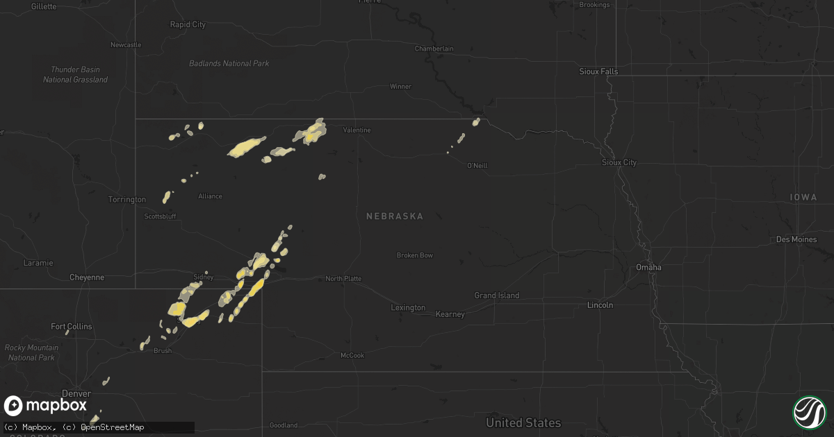
Hail Map in Nebraska on June 30, 2011
Get this storm
June 30 map
$229
one time, instant access
Download today. No call, no setup
Keep the $229
Bought the map and want the full workflow? Apply the entire $229 to a subscription within 7 days. None of it is wasted.
Every map, not just this one
This buys you this map. Subscription and you get every map we run, in the markets you choose from a few cities to whole states to nationwide. Plus real-time alerts the moment a storm fires.
Contact data
Name, contact info, occupancy, even credit band for addresses in the footprint. You go from where it hit to who to call.
Become the source they trust
Unlimited branding weather history reports on demand. You already have the documented answer ready for the property owner, and you are the one who showed up with it.
Property data and RoofTrace estimates
Pull up any address you have got, its value and the exact code rules for that jurisdiction, straight from One Click Code. Then RoofTrace estimates the squares, pitch, and roof value, priced the way you price.
Storm reports in Nebraska
Nebraska
| Date | Description |
|---|---|
| 06/30/20116:33 PM CDT | A local report indicates 62 MPH wind near BIG SPRINGS |
| 06/30/20116:30 PM CDT | A local report indicates 1.00 inch wind near 2 N LISCO |
| 06/30/20116:30 PM CDT | A local report indicates 1.50 inch wind near 4 SSW CHAPPELL |
| 06/30/20115:42 PM CDT | Sidney airport. |
| 06/30/20115:15 PM CDT | A local report indicates 1.00 inch wind near CHADRON |
| 06/30/20115:06 PM CDT | 60 mph winds also. |
| 06/29/20119:20 PM CDT | A local report indicates 65 MPH wind near 2 W SPARKS |
| 06/29/20119:03 PM CDT | A local report indicates 72 MPH wind near VALENTINE |
| 06/29/20118:50 PM CDT | Estimated that winds gusted up to 80 mph with 60 mph winds continuing for 30 to 45 min. Powerlines were down in the nenzel area. |
| 06/29/20118:45 PM CDT | A local report indicates 1.00 inch wind near 3 SW CODY |
| 06/29/20118:45 PM CDT | A local report indicates 60 MPH wind near 3 SW CODY |
| 06/29/20118:33 PM CDT | A local report indicates 65 MPH wind near MERRIMAN |
| 06/29/20118:30 PM CDT | Estimated 80 mph wind gusts with significant damage to trees and structures. Part of the roof was torn off the house with a 20 by 40 foot wooden structure completely bl |
| 06/29/20118:25 PM CDT | A local report indicates 60 MPH wind near MERRIMAN |
| 06/29/20118:16 PM CDT | A local report indicates 1.00 inch wind near 10 ENE ARTHUR |
| 06/29/20118:16 PM CDT | A local report indicates 70 MPH wind near 10 ENE ARTHUR |
| 06/29/20118:15 PM CDT | A full grown pine tree was uprooted and fell on the residents house. Small shed was destroyed with pieces littered across the yard. |
| 06/29/20118:05 PM CDT | A local report indicates 60 MPH wind near 26 SSW MERRIMAN |
| 06/29/20117:45 PM CDT | Also winds of 50 mph or more as the storm passed |
| 06/29/20117:40 PM CDT | A local report indicates 60 MPH wind near 5 SE RUSHVILLE |
| 06/29/20117:15 PM CDT | A local report indicates 1.50 inch wind near 1 S BIG SPRINGS |
| 06/29/20117:05 PM CDT | A local report indicates 1.25 inch wind near 1 S LEWELLEN |
All States Impacted by Hail Map on June 30, 2011
Cities Impacted by Hail Map on June 30, 2011
- Homer, LA
- Pineland, SC
- Tillman, SC
- Ovid, CO
- Crook, CO
- Chappell, NE
- Sedgwick, CO
- Valparaiso, IN
- Preston, GA
- East Carbon, UT
- Deadwood, SD
- Sturgis, SD
- Piedmont, SD
- Lodge Grass, MT
- Momence, IL
- Hodgen, OK
- Heavener, OK
- Lemoyne, NE
- Thomasville, GA
- Watson, OK
- Newton, GA
- Colquitt, GA
- Merriman, NE
- El Dorado, AR
- Junction City, AR
- Spencer, NE
- Green River, UT
- Muse, OK
- Whitesboro, OK
- Chesterton, IN
- Portage, IN
- Booneville, AR
- Mulberry, AR
- Chicago, IL
- Dolton, IL
- Riverdale, IL
- Evergreen Park, IL
- Cicero, IL
- Evanston, IL
- Blue Island, IL
- Longview, TX
- Oglala, SD
- Pine Ridge, SD
- Pentwater, MI
- Fleming, CO
- Sterling, CO
- Alsip, IL
- Markham, IL
- South Holland, IL
- Harvey, IL
- Glenwood, IL
- Posen, IL
- Homewood, IL
- Hazel Crest, IL
- Calumet City, IL
- Thornton, IL
- Hamlet, IN
- Arthur, NE
- Cameron, OK
- Clarksville, TX
- Bagwell, TX
- Soperton, GA
- Adrian, GA
- Merino, CO
- Padroni, CO
- Atwood, CO
- Spiro, OK
- Lewellen, NE
- Tallahassee, FL
- Crawford, NE
- Foreman, AR
- Hooks, TX
- Ashdown, AR
- New Boston, TX
- Grovertown, IN
- Walkerton, IN
- Lamont, FL
- Haynesville, LA
- Emerson, AR
- Sheridan, WY
- Torrington, WY
- Bradley, AR
- Maybell, CO
- Jay Em, WY
- Fort Laramie, WY
- Benton, LA
- Vernal, UT
- Grant Park, IL
- Buckner, AR
- Stamps, AR
- Banner, WY
- Big Horn, WY
- Story, WY
- Texarkana, AR
- Texarkana, TX
- Franktown, CO
- Elizabeth, CO
- Parker, CO
- Rushville, NE
- Beecher, IL
- Peotone, IL
- Grand Saline, TX
- Alba, TX
- Richton Park, IL
- Bivins, TX
- Newhope, AR
- Dubach, LA
- Gilmer, TX
- Dinosaur, CO
- Wister, OK
- Marshall, TX
- Stephens, AR
- Haxtun, CO
- Fort Lauderdale, FL
- Decker, MT
- Clyo, GA
- Mena, AR
- Brule, NE
- Big Springs, NE
- Crete, IL
- Steger, IL
- Olympia Fields, IL
- Monee, IL
- University Park, IL
- Park Forest, IL
- Chicago Heights, IL
- Whigham, GA
- Pelham, GA
- Camilla, GA
- Porcupine, SD
- Alamo, GA
- Stoneham, CO
- Emory, TX
- De Beque, CO
- Rifle, CO
- Hackett, AR
- Chadron, NE
- Gordon, NE
- Greenville, FL
- Ridgeland, SC
- Eufaula, OK
- Stigler, OK
- Quinton, OK
- Checotah, OK
- Magnolia, AR
- Chester, AR
- Whiting, IN
- Robbins, IL
- Kenilworth, IL
- Wilmette, IL
- Oak Lawn, IL
- Hometown, IL
- Lansing, IL
- Skokie, IL
- Hammond, IN
- Lincolnwood, IL
- Chatsworth, IL
- Forrest, IL
- Waskom, TX
- Karnack, TX
- Crawfordville, FL
- Mount Holly, AR
- Smithville, OK
- Honobia, OK
- Haughton, LA
- Princeton, LA
- Hemingford, NE
- Parmelee, SD
- Norris, SD
- Clearmont, WY
- De Kalb, TX
- Alzada, MT
- Hobart, IN
- Crown Point, IN
- Merrillville, IN
- Honey Grove, TX
- Sumner, TX
- Matteson, IL
- Cody, NE
- Nenzel, NE
- Arcadia, LA
- Sierra Vista, AZ
- Fort Huachuca, AZ
- Linden, TX
- Jefferson, TX
- Sidney, NE
- Umpire, AR
- Alma, AR
- Mountainburg, AR
- Pompano Beach, FL
- Julesburg, CO
- Berryville, AR
- Eureka Springs, AR
- Talihina, OK
- Rangely, CO
- Taylor, AR
- Yemassee, SC
- Coosawhatchie, SC
- Climax, GA
- Bainbridge, GA
- Pecan Gap, TX
- Cooper, TX
- Ludington, MI
- Gibsland, LA
- Red Oak, OK
- Thompson, UT
- Swainsboro, GA
- Plain Dealing, LA
- Moorcroft, WY
- Hulett, WY
- Weston, WY
- Algoma, WI
- Kewaunee, WI
- Lockesburg, AR
- Oak Forest, IL
- Peetz, CO
- Somerset, CO
- Garfield, GA
- Twin City, GA
- Price, UT
- Langley, AR
- Hardeeville, SC
- Okatie, SC
- Elgin, AZ
- Mooringsport, LA
- Weldona, CO
- Casco, WI
- Dry Branch, GA
- Alliance, NE
- Gary, IN
- Sundance, WY
- Devils Tower, WY
- Heflin, LA
- Dubberly, LA
- Sibley, LA
- Pineland, TX
- Omaha, TX
- Mcalester, OK
- Lamar, OK
- Sulphur Springs, TX
- Snyder, CO
- Lowell, IN
- Hebron, IN
- Demotte, IN
- Gloster, MS
- Liberty, MS
- Wyola, MT
- Frankfort, MI
- Holyoke, CO
- Guyton, GA
- Manteno, IL
- Macon, GA
- Wrightsville, GA
- East Dublin, GA
- Atkinson, NE
- Fulton, AR
- Hope, AR
- Albany, GA
- Stuart, NE
- Gypsum, CO
- Hemphill, TX
- Bronson, TX
- Mccurtain, OK
- Fruita, CO
- Grand Junction, CO
- Lewisville, AR
- White River, SD
- Okaton, SD
- Saint Francis, SD
- Lake Station, IN
- Meeker, CO
- Saint John, IN
- Dyer, IN
- Schererville, IN
- Fort Collins, CO
- Loveland, CO
- Brashear, TX
- Cumby, TX
- Florien, LA
- Pittsburg, TX
- Porum, OK
- Kinta, OK
- Hay Springs, NE
- Rosston, AR
- Manderson, SD
- Lake Village, IN
- Schneider, IN
- Havana, FL
- Hanna, WY
- Kilgore, NE
- Oelrichs, SD
- Charleston, AR
- Dyer, AR
- Waldo, AR
- Whitman, NE
- Hyannis, NE
- Montague, MI
- New Era, MI
- Simsboro, LA
- Castle Rock, CO
- Avery, TX
- Wilburton, OK
- Oshkosh, NE
- Pagosa Springs, CO
- Bokoshe, OK
- Keota, OK
- East Chicago, IN
- Munster, IN
- Flossmoor, IL
- Midlothian, IL
- Murdo, SD
- Poteau, OK
- Huntington, UT
- Pocola, OK
- Wheatfield, IN
- Bentonville, AR
- Hart, MI
- Shelby, MI
- Mears, MI
- Monticello, FL
- Jeffersonville, GA
- Bangor, MI
- Port Wentworth, GA
- Daingerfield, TX
- Naples, TX
- Larkspur, CO
- Shongaloo, LA
- Mineral Springs, AR
- Bethel, OK
- Whitney, NE
- Hollywood, FL
- Pembroke Township, IL
- Beaverville, IL
- Morocco, IN
- Atlanta, TX
- Roxton, TX
- Kilgore, TX
- Lisbon, LA
- Manistee, MI
- Free Soil, MI
- Rockledge, GA
- Kite, GA
- Mineola, TX
- Newington, GA
- Springfield, GA
- Bernice, LA
- Summerfield, LA
- Waldron, AR
- Klondike, TX
- Moncks Corner, SC
- Ferron, UT
- Paris, MI
- Valley, AL
- Salem, AL
- Smackover, AR
- Minden, LA
- Columbia, AL
- Fort Morgan, CO
- Cedar Lake, IN
- Kouts, IN
- Bennett, CO
- Watkins, CO
- Garnett, SC
- Kirby, AR
- Valentine, NE


