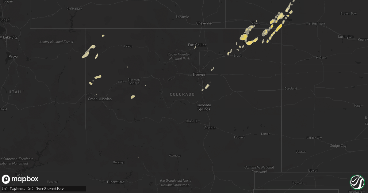
Hail Map in Colorado on June 30, 2011
Get this storm
June 30 map
$229
one time, instant access
Download today. No call, no setup
Keep the $229
Bought the map and want the full workflow? Apply the entire $229 to a subscription within 7 days. None of it is wasted.
Every map, not just this one
This buys you this map. Subscription and you get every map we run, in the markets you choose from a few cities to whole states to nationwide. Plus real-time alerts the moment a storm fires.
Contact data
Name, contact info, occupancy, even credit band for addresses in the footprint. You go from where it hit to who to call.
Become the source they trust
Unlimited branding weather history reports on demand. You already have the documented answer ready for the property owner, and you are the one who showed up with it.
Property data and RoofTrace estimates
Pull up any address you have got, its value and the exact code rules for that jurisdiction, straight from One Click Code. Then RoofTrace estimates the squares, pitch, and roof value, priced the way you price.
Storm reports in Colorado
Colorado
| Date | Description |
|---|---|
| 06/30/20116:58 PM CDT | A local report indicates 1.25 inch wind near 6 SE JULESBURG |
| 06/30/20116:42 PM CDT | A local report indicates 1.00 inch wind near 11 S OVID |
| 06/30/20116:39 PM CDT | A local report indicates 66 MPH wind near AIR FORCE ACADEMY |
| 06/30/20116:28 PM CDT | A local report indicates 67 MPH wind near AIR FORCE ACADEMY |
| 06/30/20116:25 PM CDT | Old 50 foot tree blown down. Small branches blown off on other trees in vicinity. |
| 06/30/20116:18 PM CDT | A local report indicates 1.00 inch wind near SEDGWICK |
| 06/30/20115:35 PM CDT | 50 foot tree blown onto roof. Fences toppled and shingles removed. Loose objects lifted and tossed. Damage to 4 homes. Power lines down in granby and vicinity. |
| 06/30/20115:02 PM CDT | A local report indicates 58 MPH wind near 1 E STERLING |
| 06/30/20114:55 PM CDT | A local report indicates 62 MPH wind near 15 W STERLING |
| 06/30/20114:44 PM CDT | A local report indicates 61 MPH wind near 2 N WOLCOTT |
| 06/30/20114:43 PM CDT | A local report indicates 70 MPH wind near 2 S WILLARD |
| 06/30/20114:32 PM CDT | Large cottonwood tree blow over |
| 06/30/20114:30 PM CDT | A local report indicates 60 MPH wind near GYPSUM |
| 06/30/20114:30 PM CDT | A local report indicates 60 MPH wind near 2 SSW GYPSUM |
| 06/30/20114:28 PM CDT | A local report indicates 69 MPH wind near GYPSUM |
| 06/30/20113:36 PM CDT | A local report indicates 1.00 inch wind near GRAND JUNCTION |
| 06/30/20112:20 PM CDT | A local report indicates 62 MPH wind near 2 S BUENA VISTA |
| 06/30/20112:16 PM CDT | Measured at kaej |
| 06/30/20112:15 PM CDT | Measured at k7bm |
| 06/30/20111:22 PM CDT | Pea size hail and 60 mph winds estimated at dinosaur national monument. Branches falling off trees. |
| 06/30/20111:17 PM CDT | A local report indicates 63 MPH wind near 7 SE DENVER INTL AIRPOR |
| 06/30/20111:14 PM CDT | A local report indicates 63 MPH wind near 3 SE DENVER INTL AIRPOR |
| 06/30/20111:10 PM CDT | Moved a pole barn about 5 feet. |
| 06/30/20111:09 PM CDT | 60 mph winds with 0.50 inch hail. |
| 06/29/201110:50 PM CDT | A local report indicates 1.00 inch wind near 2 SSE PARKER |
| 06/29/20118:16 PM CDT | A local report indicates 65 MPH wind near 2 NE BOULDER |
| 06/29/20118:10 PM CDT | A local report indicates 62 MPH wind near ROGGEN |
| 06/29/20117:02 PM CDT | A local report indicates 1.00 inch wind near 5 SE JULESBURG |
All States Impacted by Hail Map on June 30, 2011
Cities Impacted by Hail Map on June 30, 2011
- Homer, LA
- Pineland, SC
- Tillman, SC
- Ovid, CO
- Crook, CO
- Chappell, NE
- Sedgwick, CO
- Valparaiso, IN
- Preston, GA
- East Carbon, UT
- Deadwood, SD
- Sturgis, SD
- Piedmont, SD
- Lodge Grass, MT
- Momence, IL
- Hodgen, OK
- Heavener, OK
- Lemoyne, NE
- Thomasville, GA
- Watson, OK
- Newton, GA
- Colquitt, GA
- Merriman, NE
- El Dorado, AR
- Junction City, AR
- Spencer, NE
- Green River, UT
- Muse, OK
- Whitesboro, OK
- Chesterton, IN
- Portage, IN
- Booneville, AR
- Mulberry, AR
- Chicago, IL
- Dolton, IL
- Riverdale, IL
- Evergreen Park, IL
- Cicero, IL
- Evanston, IL
- Blue Island, IL
- Longview, TX
- Oglala, SD
- Pine Ridge, SD
- Pentwater, MI
- Fleming, CO
- Sterling, CO
- Alsip, IL
- Markham, IL
- South Holland, IL
- Harvey, IL
- Glenwood, IL
- Posen, IL
- Homewood, IL
- Hazel Crest, IL
- Calumet City, IL
- Thornton, IL
- Hamlet, IN
- Arthur, NE
- Cameron, OK
- Clarksville, TX
- Bagwell, TX
- Soperton, GA
- Adrian, GA
- Merino, CO
- Padroni, CO
- Atwood, CO
- Spiro, OK
- Lewellen, NE
- Tallahassee, FL
- Crawford, NE
- Foreman, AR
- Hooks, TX
- Ashdown, AR
- New Boston, TX
- Grovertown, IN
- Walkerton, IN
- Lamont, FL
- Haynesville, LA
- Emerson, AR
- Sheridan, WY
- Torrington, WY
- Bradley, AR
- Maybell, CO
- Jay Em, WY
- Fort Laramie, WY
- Benton, LA
- Vernal, UT
- Grant Park, IL
- Buckner, AR
- Stamps, AR
- Banner, WY
- Big Horn, WY
- Story, WY
- Texarkana, AR
- Texarkana, TX
- Franktown, CO
- Elizabeth, CO
- Parker, CO
- Rushville, NE
- Beecher, IL
- Peotone, IL
- Grand Saline, TX
- Alba, TX
- Richton Park, IL
- Bivins, TX
- Newhope, AR
- Dubach, LA
- Gilmer, TX
- Dinosaur, CO
- Wister, OK
- Marshall, TX
- Stephens, AR
- Haxtun, CO
- Fort Lauderdale, FL
- Decker, MT
- Clyo, GA
- Mena, AR
- Brule, NE
- Big Springs, NE
- Crete, IL
- Steger, IL
- Olympia Fields, IL
- Monee, IL
- University Park, IL
- Park Forest, IL
- Chicago Heights, IL
- Whigham, GA
- Pelham, GA
- Camilla, GA
- Porcupine, SD
- Alamo, GA
- Stoneham, CO
- Emory, TX
- De Beque, CO
- Rifle, CO
- Hackett, AR
- Chadron, NE
- Gordon, NE
- Greenville, FL
- Ridgeland, SC
- Eufaula, OK
- Stigler, OK
- Quinton, OK
- Checotah, OK
- Magnolia, AR
- Chester, AR
- Whiting, IN
- Robbins, IL
- Kenilworth, IL
- Wilmette, IL
- Oak Lawn, IL
- Hometown, IL
- Lansing, IL
- Skokie, IL
- Hammond, IN
- Lincolnwood, IL
- Chatsworth, IL
- Forrest, IL
- Waskom, TX
- Karnack, TX
- Crawfordville, FL
- Mount Holly, AR
- Smithville, OK
- Honobia, OK
- Haughton, LA
- Princeton, LA
- Hemingford, NE
- Parmelee, SD
- Norris, SD
- Clearmont, WY
- De Kalb, TX
- Alzada, MT
- Hobart, IN
- Crown Point, IN
- Merrillville, IN
- Honey Grove, TX
- Sumner, TX
- Matteson, IL
- Cody, NE
- Nenzel, NE
- Arcadia, LA
- Sierra Vista, AZ
- Fort Huachuca, AZ
- Linden, TX
- Jefferson, TX
- Sidney, NE
- Umpire, AR
- Alma, AR
- Mountainburg, AR
- Pompano Beach, FL
- Julesburg, CO
- Berryville, AR
- Eureka Springs, AR
- Talihina, OK
- Rangely, CO
- Taylor, AR
- Yemassee, SC
- Coosawhatchie, SC
- Climax, GA
- Bainbridge, GA
- Pecan Gap, TX
- Cooper, TX
- Ludington, MI
- Gibsland, LA
- Red Oak, OK
- Thompson, UT
- Swainsboro, GA
- Plain Dealing, LA
- Moorcroft, WY
- Hulett, WY
- Weston, WY
- Algoma, WI
- Kewaunee, WI
- Lockesburg, AR
- Oak Forest, IL
- Peetz, CO
- Somerset, CO
- Garfield, GA
- Twin City, GA
- Price, UT
- Langley, AR
- Hardeeville, SC
- Okatie, SC
- Elgin, AZ
- Mooringsport, LA
- Weldona, CO
- Casco, WI
- Dry Branch, GA
- Alliance, NE
- Gary, IN
- Sundance, WY
- Devils Tower, WY
- Heflin, LA
- Dubberly, LA
- Sibley, LA
- Pineland, TX
- Omaha, TX
- Mcalester, OK
- Lamar, OK
- Sulphur Springs, TX
- Snyder, CO
- Lowell, IN
- Hebron, IN
- Demotte, IN
- Gloster, MS
- Liberty, MS
- Wyola, MT
- Frankfort, MI
- Holyoke, CO
- Guyton, GA
- Manteno, IL
- Macon, GA
- Wrightsville, GA
- East Dublin, GA
- Atkinson, NE
- Fulton, AR
- Hope, AR
- Albany, GA
- Stuart, NE
- Gypsum, CO
- Hemphill, TX
- Bronson, TX
- Mccurtain, OK
- Fruita, CO
- Grand Junction, CO
- Lewisville, AR
- White River, SD
- Okaton, SD
- Saint Francis, SD
- Lake Station, IN
- Meeker, CO
- Saint John, IN
- Dyer, IN
- Schererville, IN
- Fort Collins, CO
- Loveland, CO
- Brashear, TX
- Cumby, TX
- Florien, LA
- Pittsburg, TX
- Porum, OK
- Kinta, OK
- Hay Springs, NE
- Rosston, AR
- Manderson, SD
- Lake Village, IN
- Schneider, IN
- Havana, FL
- Hanna, WY
- Kilgore, NE
- Oelrichs, SD
- Charleston, AR
- Dyer, AR
- Waldo, AR
- Whitman, NE
- Hyannis, NE
- Montague, MI
- New Era, MI
- Simsboro, LA
- Castle Rock, CO
- Avery, TX
- Wilburton, OK
- Oshkosh, NE
- Pagosa Springs, CO
- Bokoshe, OK
- Keota, OK
- East Chicago, IN
- Munster, IN
- Flossmoor, IL
- Midlothian, IL
- Murdo, SD
- Poteau, OK
- Huntington, UT
- Pocola, OK
- Wheatfield, IN
- Bentonville, AR
- Hart, MI
- Shelby, MI
- Mears, MI
- Monticello, FL
- Jeffersonville, GA
- Bangor, MI
- Port Wentworth, GA
- Daingerfield, TX
- Naples, TX
- Larkspur, CO
- Shongaloo, LA
- Mineral Springs, AR
- Bethel, OK
- Whitney, NE
- Hollywood, FL
- Pembroke Township, IL
- Beaverville, IL
- Morocco, IN
- Atlanta, TX
- Roxton, TX
- Kilgore, TX
- Lisbon, LA
- Manistee, MI
- Free Soil, MI
- Rockledge, GA
- Kite, GA
- Mineola, TX
- Newington, GA
- Springfield, GA
- Bernice, LA
- Summerfield, LA
- Waldron, AR
- Klondike, TX
- Moncks Corner, SC
- Ferron, UT
- Paris, MI
- Valley, AL
- Salem, AL
- Smackover, AR
- Minden, LA
- Columbia, AL
- Fort Morgan, CO
- Cedar Lake, IN
- Kouts, IN
- Bennett, CO
- Watkins, CO
- Garnett, SC
- Kirby, AR
- Valentine, NE


