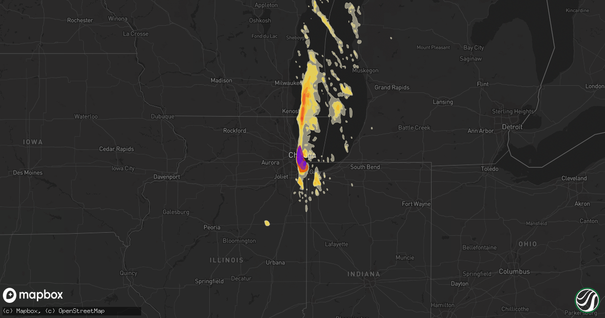
Hail Map on June 30, 2011
Get this storm
June 30 map
$229
one time, instant access
Download today. No call, no setup
Keep the $229
Bought the map and want the full workflow? Apply the entire $229 to a subscription within 7 days. None of it is wasted.
Every map, not just this one
This buys you this map. Subscription and you get every map we run, in the markets you choose from a few cities to whole states to nationwide. Plus real-time alerts the moment a storm fires.
Contact data
Name, contact info, occupancy, even credit band for addresses in the footprint. You go from where it hit to who to call.
Become the source they trust
Unlimited branding weather history reports on demand. You already have the documented answer ready for the property owner, and you are the one who showed up with it.
Property data and RoofTrace estimates
Pull up any address you have got, its value and the exact code rules for that jurisdiction, straight from One Click Code. Then RoofTrace estimates the squares, pitch, and roof value, priced the way you price.
States Impacted by Hail Map on June 30, 2011
Storm reports
Nebraska
| Date | Description |
|---|---|
| 06/30/20116:33 PM CDT | A local report indicates 62 MPH wind near BIG SPRINGS |
| 06/30/20116:30 PM CDT | A local report indicates 1.50 inch wind near 4 SSW CHAPPELL |
| 06/30/20116:30 PM CDT | A local report indicates 1.00 inch wind near 2 N LISCO |
| 06/30/20115:42 PM CDT | Sidney airport. |
| 06/30/20115:15 PM CDT | A local report indicates 1.00 inch wind near CHADRON |
| 06/30/20115:06 PM CDT | 60 mph winds also. |
| 06/29/20119:20 PM CDT | A local report indicates 65 MPH wind near 2 W SPARKS |
| 06/29/20119:03 PM CDT | A local report indicates 72 MPH wind near VALENTINE |
| 06/29/20118:50 PM CDT | Estimated that winds gusted up to 80 mph with 60 mph winds continuing for 30 to 45 min. Powerlines were down in the nenzel area. |
| 06/29/20118:45 PM CDT | A local report indicates 1.00 inch wind near 3 SW CODY |
| 06/29/20118:45 PM CDT | A local report indicates 60 MPH wind near 3 SW CODY |
| 06/29/20118:33 PM CDT | A local report indicates 65 MPH wind near MERRIMAN |
| 06/29/20118:30 PM CDT | Estimated 80 mph wind gusts with significant damage to trees and structures. Part of the roof was torn off the house with a 20 by 40 foot wooden structure completely bl |
| 06/29/20118:25 PM CDT | A local report indicates 60 MPH wind near MERRIMAN |
| 06/29/20118:16 PM CDT | A local report indicates 1.00 inch wind near 10 ENE ARTHUR |
| 06/29/20118:16 PM CDT | A local report indicates 70 MPH wind near 10 ENE ARTHUR |
| 06/29/20118:15 PM CDT | A full grown pine tree was uprooted and fell on the residents house. Small shed was destroyed with pieces littered across the yard. |
| 06/29/20118:05 PM CDT | A local report indicates 60 MPH wind near 26 SSW MERRIMAN |
| 06/29/20117:45 PM CDT | Also winds of 50 mph or more as the storm passed |
| 06/29/20117:40 PM CDT | A local report indicates 60 MPH wind near 5 SE RUSHVILLE |
| 06/29/20117:15 PM CDT | A local report indicates 1.50 inch wind near 1 S BIG SPRINGS |
| 06/29/20117:05 PM CDT | A local report indicates 1.25 inch wind near 1 S LEWELLEN |
Utah
| Date | Description |
|---|---|
| 06/30/201112:54 PM CDT | 60 mph wind gusts with pea size hail. |
Colorado
| Date | Description |
|---|---|
| 06/30/20116:58 PM CDT | A local report indicates 1.25 inch wind near 6 SE JULESBURG |
| 06/30/20116:42 PM CDT | A local report indicates 1.00 inch wind near 11 S OVID |
| 06/30/20116:39 PM CDT | A local report indicates 66 MPH wind near AIR FORCE ACADEMY |
| 06/30/20116:28 PM CDT | A local report indicates 67 MPH wind near AIR FORCE ACADEMY |
| 06/30/20116:25 PM CDT | Old 50 foot tree blown down. Small branches blown off on other trees in vicinity. |
| 06/30/20116:18 PM CDT | A local report indicates 1.00 inch wind near SEDGWICK |
| 06/30/20115:35 PM CDT | 50 foot tree blown onto roof. Fences toppled and shingles removed. Loose objects lifted and tossed. Damage to 4 homes. Power lines down in granby and vicinity. |
| 06/30/20115:02 PM CDT | A local report indicates 58 MPH wind near 1 E STERLING |
| 06/30/20114:55 PM CDT | A local report indicates 62 MPH wind near 15 W STERLING |
| 06/30/20114:44 PM CDT | A local report indicates 61 MPH wind near 2 N WOLCOTT |
| 06/30/20114:43 PM CDT | A local report indicates 70 MPH wind near 2 S WILLARD |
| 06/30/20114:32 PM CDT | Large cottonwood tree blow over |
| 06/30/20114:30 PM CDT | A local report indicates 60 MPH wind near GYPSUM |
| 06/30/20114:30 PM CDT | A local report indicates 60 MPH wind near 2 SSW GYPSUM |
| 06/30/20114:28 PM CDT | A local report indicates 69 MPH wind near GYPSUM |
| 06/30/20113:36 PM CDT | A local report indicates 1.00 inch wind near GRAND JUNCTION |
| 06/30/20112:20 PM CDT | A local report indicates 62 MPH wind near 2 S BUENA VISTA |
| 06/30/20112:16 PM CDT | Measured at kaej |
| 06/30/20112:15 PM CDT | Measured at k7bm |
| 06/30/20111:22 PM CDT | Pea size hail and 60 mph winds estimated at dinosaur national monument. Branches falling off trees. |
| 06/30/20111:17 PM CDT | A local report indicates 63 MPH wind near 7 SE DENVER INTL AIRPOR |
| 06/30/20111:14 PM CDT | A local report indicates 63 MPH wind near 3 SE DENVER INTL AIRPOR |
| 06/30/20111:10 PM CDT | Moved a pole barn about 5 feet. |
| 06/30/20111:09 PM CDT | 60 mph winds with 0.50 inch hail. |
| 06/29/201110:50 PM CDT | A local report indicates 1.00 inch wind near 2 SSE PARKER |
| 06/29/20118:16 PM CDT | A local report indicates 65 MPH wind near 2 NE BOULDER |
| 06/29/20118:10 PM CDT | A local report indicates 62 MPH wind near ROGGEN |
| 06/29/20117:02 PM CDT | A local report indicates 1.00 inch wind near 5 SE JULESBURG |
Illinois
| Date | Description |
|---|---|
| 06/29/201110:00 PM CDT | A local report indicates 1.75 inch wind near HARVEY |
| 06/29/20119:45 PM CDT | A local report indicates 1.50 inch wind near EVERGREEN PARK |
| 06/29/20119:35 PM CDT | Estimated golfball to baseball size hail. W 26th and s kedzie ave. Damage to vehicles. |
| 06/29/20119:33 PM CDT | 26th and central ave |
| 06/29/20119:33 PM CDT | 5th and pulaski |
| 06/29/20119:30 PM CDT | Estimated 1.5 to 2 inch hail. |
| 06/29/20119:30 PM CDT | Ravenswood. |
| 06/29/20119:27 PM CDT | A local report indicates 1.50 inch wind near CHICAGO |
| 06/29/20119:27 PM CDT | A local report indicates 1.75 inch wind near 5 NW CHICAGO |
| 06/29/20119:26 PM CDT | In lakeview neighborhood |
| 06/29/20119:25 PM CDT | Intersection of erie and racine |
| 06/29/20119:20 PM CDT | At the corner of rt 1 and crete-monee rd |
| 06/29/20119:18 PM CDT | Report relayed by will county ema |
| 06/29/20119:18 PM CDT | Reported relayed by will county ema |
| 06/29/20118:50 PM CDT | In zion beach state park there are multiple large trees down. Structures and mobile campers sustained damage from the falling trees |
| 06/29/20118:50 PM CDT | A local report indicates 60 MPH wind near HOMETOWN |
| 06/29/20118:50 PM CDT | Structural damage to a house caused by a fallen tree |
| 06/29/20118:30 PM CDT | At the corner of wadsworth and glen bay rd there are trees down...along with large branches. |
| 06/29/20118:30 PM CDT | A tree fell on a car. |
| 06/29/20118:30 PM CDT | In the north point marina there were reports of damaged boats...torn sails...light poles down...and trees greater than 12 inches in diameter fallen. |
| 06/29/20118:19 PM CDT | Large trees uprooted. |
| 06/29/20118:19 PM CDT | Structural damage to a house caused by a fallen tree |
South Dakota
| Date | Description |
|---|---|
| 06/30/20115:40 PM CDT | Hail damaged police cars |
| 06/30/20115:39 PM CDT | 6-8 inch diameter branches snapped off trees |
| 06/30/20115:38 PM CDT | A local report indicates 60 MPH wind near OGLALA |
| 06/30/20114:30 PM CDT | Estimated 60 mph winds blew over a propane tank and damaged an outbuilding. |
| 06/30/20119:25 AM CDT | Magpie creek raws site |
| 06/29/201111:00 PM CDT | Measured at ft pierre raws site. Time approximate. |
| 06/29/201111:00 PM CDT | 3 foot diameter tree down with other tree damage scattered throughout the city. Power also out in parts of pierre. |
| 06/29/201110:55 PM CDT | Tree branches down |
| 06/29/201110:35 PM CDT | A local report indicates 60 MPH wind near 3 S CHAMBERLAIN |
| 06/29/201110:23 PM CDT | A local report indicates 60 MPH wind near 5 N HAMILL |
| 06/29/201110:14 PM CDT | A local report indicates 60 MPH wind near 4 E HAMILL |
| 06/29/201110:10 PM CDT | Power lines snapped and downed in murdo. Winds estimated 60 to 70 mph. |
| 06/29/201110:08 PM CDT | A local report indicates 60 MPH wind near 9 N CEDAR BUTTE |
| 06/29/20119:57 PM CDT | Kicr asos |
| 06/29/20119:45 PM CDT | A local report indicates 60 MPH wind near WHITE RIVER |
| 06/29/20119:40 PM CDT | Blew shingles off roof and overturned small structure |
| 06/29/20119:30 PM CDT | A local report indicates 60 MPH wind near NORRIS |
| 06/29/20119:25 PM CDT | Magpie creek raws site |
| 06/29/20119:25 PM CDT | A local report indicates 60 MPH wind near ROSEBUD |
| 06/29/20119:20 PM CDT | Power poles down and damage to small buildings |
| 06/29/20119:11 PM CDT | A local report indicates 60 MPH wind near SAINT FRANCIS |
| 06/29/20119:01 PM CDT | A local report indicates 60 MPH wind near VETAL |
Wisconsin
| Date | Description |
|---|---|
| 06/29/20118:11 PM CDT | Measured peak wind gust at kenosha airport |
| 06/29/20118:06 PM CDT | Several large uprooted trees reported near the lakeshore in kenosha |
| 06/29/20118:00 PM CDT | Severe tree damage and power poles snapped. Time estimated. |
| 06/29/20117:50 PM CDT | Several large trees down across the area |
| 06/29/20117:49 PM CDT | Measured peak wind gust at racine airport |
| 06/29/20117:47 PM CDT | Small branches down and shingles blown off several houses. |
Oklahoma
| Date | Description |
|---|---|
| 06/30/20114:22 PM CDT | A local report indicates 1.00 inch wind near CAMERON |
Georgia
| Date | Description |
|---|---|
| 06/30/20114:34 PM CDT | Power lines down. |
| 06/30/20114:28 PM CDT | 911 call center reported power line poles down on clyo-kildare and reedsville road. |
| 06/30/20114:18 PM CDT | Tree down blocking both lanes of highway 17 |
| 06/30/20114:15 PM CDT | 911 call center reported power line poles down on clyo-kildare and reedsville road. Time estimated by radar. |
| 06/30/20114:15 PM CDT | Power lines down. Time estimated by radar. |
| 06/30/20114:10 PM CDT | Tree down blocking both lanes of springfield-egypt road |
| 06/30/20114:04 PM CDT | Tree on power lines on fletcher lane |
| 06/30/20113:45 PM CDT | Power lines down. Time estimated by radar. |
| 06/30/20113:45 PM CDT | Tree down blocking both lanes of highway 17 |
| 06/30/20113:45 PM CDT | 911 call center reported power line poles down on clyo-kildare and reedsville road. Time estimated by radar. |
| 06/30/20113:40 PM CDT | Multiple trees down at river rd and cr311. |
| 06/29/20117:37 PM CDT | Laurens county em relayed a report of several trees down in the eastern part of the county near lowery...in addition to the two previous trees down. The em also reporte |
| 06/29/20117:19 PM CDT | Em relayed a report of several trees down in scott. |
| 06/29/20117:19 PM CDT | Laurens county 911 relayed a report of two tress down in the eastern part of laurens county. |
South Carolina
| Date | Description |
|---|---|
| 06/30/20113:35 PM CDT | Tree down on cotton hill road near tarboro |
| 06/30/20113:00 PM CDT | Tree down on morgandollar road near coosawhatchie |
Wyoming
| Date | Description |
|---|---|
| 06/30/20116:51 PM CDT | 0.70 inches of rain |
| 06/30/20116:00 PM CDT | Hvy rain. |
| 06/30/20114:52 PM CDT | A local report indicates 60 MPH wind near 10 N CHEYENNE |
| 06/29/20119:15 PM CDT | Extensive 1/4 to 1/2 inch hail |
| 06/29/20118:33 PM CDT | A local report indicates 1.00 inch wind near 2 NE ROCKYPOINT |
| 06/29/20118:33 PM CDT | A local report indicates 60 MPH wind near 2 NE ROCKYPOINT |
| 06/29/20118:28 PM CDT | A local report indicates 1.00 inch wind near 1 N ROCKYPOINT |
| 06/29/20118:25 PM CDT | A local report indicates 60 MPH wind near 1 N ROCKYPOINT |
| 06/29/20118:07 PM CDT | A local report indicates 1.00 inch wind near 13 W ROCKYPOINT |
Arkansas
| Date | Description |
|---|---|
| 06/30/20112:05 PM CDT | Cr 93 and 164 blocked by down trees and wires. Trees down on a house and a tree down on vehicle. No injuries reported. |
Texas
| Date | Description |
|---|---|
| 06/30/20116:59 PM CDT | Two trees down |
| 06/30/20116:50 PM CDT | Trees down on hwy 271. |
| 06/30/20116:38 PM CDT | At east texas medical center. |
| 06/30/20116:30 PM CDT | Heavy wind damage was reported to a sconic drive in and to the tefteller law office in the town of gilmer. |
| 06/30/20116:30 PM CDT | Several trees were downed north of town. Two trees fell across mobile homes. There were no report of injuries. |
| 06/30/20116:25 PM CDT | Trees and power lines down |
| 06/30/20116:15 PM CDT | Sheet metal roofing was removed from a local best western inn located on main street. A motorcycle also received damage from the downed sheet metal. |
| 06/30/20116:05 PM CDT | Turned over a truck near 7724 south cage in pharr... Tornado was seen near the state farm arena in hidalgo. |
| 06/30/20116:05 PM CDT | *** 1 inj *** tornado removed roof of mobile home...debris damaged a car with minor injuries to female occupant...semi flipped over...minor damage to several homes |
| 06/30/20116:00 PM CDT | Large tree across hwy 155. |
| 06/30/20115:57 PM CDT | *** 1 inj *** ef1 tornado damaged mobile home...debris damaged a car with minor injuries to female occupant...several semis flipped over damage...minor damage to severa |
| 06/29/20118:08 PM CDT | 2 trees down across farm market road in northwest rusk county. |
| 06/29/20117:44 PM CDT | Multiple trees and power lines down. |
| 06/29/20117:30 PM CDT | Siding was removed from a car wash at west marshall and pine tree road. Wind damage also reported to the roof of an auto remair shop. Several vehicles were damaged as w |
| 06/29/20117:06 PM CDT | Hwy 80 and fm 1799 intersection multiple trees blown down. |
Montana
| Date | Description |
|---|---|
| 06/29/20119:50 PM CDT | 50 mph wind...extensive 1/4 to 1/2 in hail...heavy rain |
Florida
| Date | Description |
|---|---|
| 06/30/20113:35 PM CDT | Powerline down |
| 06/30/20113:35 PM CDT | Tree down |
| 06/30/20113:35 PM CDT | Powerline down |
| 06/30/20113:20 PM CDT | Powerline down |
| 06/30/20113:18 PM CDT | Tree down |
| 06/30/20113:16 PM CDT | Trees and power lines down in the woodville area |
| 06/30/20113:00 PM CDT | Media reported one or 2 power lines down in palm springs and west boca. |
| 06/30/20112:52 PM CDT | 60 mph wind gust measured by weather equipment at florida high school in southwood. |
| 06/30/20112:52 PM CDT | Trees down near the intersection of blairstone rd and cap. Cir. Ne as well as the intersection of tram rd and merchants row blvd. |
| 06/30/20112:52 PM CDT | Tree uprooted and stop sign blown down in southwood. |
| 06/30/20112:48 PM CDT | 6 trees and a powerline down. |
| 06/30/20112:47 PM CDT | Trees down on old bainbridge road north of west brevard street. Old bainbridge was closed at that location at that time. |
| 06/30/20112:47 PM CDT | 56 knot gust measured on roof of nws building. |
| 06/30/20112:47 PM CDT | Trees down at the intersection of w. Call st. And chapel dr. |
| 06/30/20112:45 PM CDT | Trees down at the intersection of ocala rd and honeysuckle rd. |
| 06/30/20112:45 PM CDT | Trees down at the intersection of san luis rd. And don andres dr. |
| 06/30/20112:43 PM CDT | Trees down near the intersection of capital circle ne and miccosukee rd. |
| 06/30/20112:40 PM CDT | Foxcroft drive near giles place closed due to fallen trees. |
| 06/30/20112:40 PM CDT | Trees down at the intersection of noble dr. And goose pond ct. |
| 06/30/20112:30 PM CDT | Media reported mesonet at north broward medical center with a 72 mph wind gust. |
| 06/30/20111:40 PM CDT | 61 mph wind gusts reported by mesonet located at griffen and bonaventure interestion. |
Indiana
| Date | Description |
|---|---|
| 06/30/20116:55 PM CDT | A local report indicates 1.00 inch wind near PORTAGE |
| 06/30/20116:35 PM CDT | A local report indicates 1.00 inch wind near LAKE STATION |
| 06/30/20116:10 AM CDT | Minor leaf damage. 0.33 rainfall |
Louisiana
| Date | Description |
|---|---|
| 06/30/20114:45 PM CDT | Trees down north of hwy 80 to arkansas line. |
| 06/30/20113:40 PM CDT | Trees and power lines down in jamestown. |
| 06/30/20113:30 PM CDT | Trees down along highway 80 southeast of minden. |
| 06/30/20113:20 PM CDT | Trees down in taylor. |
Cities Impacted by Hail Map on June 30, 2011
- Homer, LA
- Pineland, SC
- Tillman, SC
- Ovid, CO
- Crook, CO
- Chappell, NE
- Sedgwick, CO
- Valparaiso, IN
- Preston, GA
- East Carbon, UT
- Deadwood, SD
- Sturgis, SD
- Piedmont, SD
- Lodge Grass, MT
- Momence, IL
- Hodgen, OK
- Heavener, OK
- Lemoyne, NE
- Thomasville, GA
- Watson, OK
- Newton, GA
- Colquitt, GA
- Merriman, NE
- El Dorado, AR
- Junction City, AR
- Spencer, NE
- Green River, UT
- Muse, OK
- Whitesboro, OK
- Chesterton, IN
- Portage, IN
- Booneville, AR
- Mulberry, AR
- Chicago, IL
- Dolton, IL
- Riverdale, IL
- Evergreen Park, IL
- Cicero, IL
- Evanston, IL
- Blue Island, IL
- Longview, TX
- Oglala, SD
- Pine Ridge, SD
- Pentwater, MI
- Fleming, CO
- Sterling, CO
- Alsip, IL
- Markham, IL
- South Holland, IL
- Harvey, IL
- Glenwood, IL
- Posen, IL
- Homewood, IL
- Hazel Crest, IL
- Calumet City, IL
- Thornton, IL
- Hamlet, IN
- Arthur, NE
- Cameron, OK
- Clarksville, TX
- Bagwell, TX
- Soperton, GA
- Adrian, GA
- Merino, CO
- Padroni, CO
- Atwood, CO
- Spiro, OK
- Lewellen, NE
- Tallahassee, FL
- Crawford, NE
- Foreman, AR
- Hooks, TX
- Ashdown, AR
- New Boston, TX
- Grovertown, IN
- Walkerton, IN
- Lamont, FL
- Haynesville, LA
- Emerson, AR
- Sheridan, WY
- Torrington, WY
- Bradley, AR
- Maybell, CO
- Jay Em, WY
- Fort Laramie, WY
- Benton, LA
- Vernal, UT
- Grant Park, IL
- Buckner, AR
- Stamps, AR
- Banner, WY
- Big Horn, WY
- Story, WY
- Texarkana, AR
- Texarkana, TX
- Franktown, CO
- Elizabeth, CO
- Parker, CO
- Rushville, NE
- Beecher, IL
- Peotone, IL
- Grand Saline, TX
- Alba, TX
- Richton Park, IL
- Bivins, TX
- Newhope, AR
- Dubach, LA
- Gilmer, TX
- Dinosaur, CO
- Wister, OK
- Marshall, TX
- Stephens, AR
- Haxtun, CO
- Fort Lauderdale, FL
- Decker, MT
- Clyo, GA
- Mena, AR
- Brule, NE
- Big Springs, NE
- Crete, IL
- Steger, IL
- Olympia Fields, IL
- Monee, IL
- University Park, IL
- Park Forest, IL
- Chicago Heights, IL
- Whigham, GA
- Pelham, GA
- Camilla, GA
- Porcupine, SD
- Alamo, GA
- Stoneham, CO
- Emory, TX
- De Beque, CO
- Rifle, CO
- Hackett, AR
- Chadron, NE
- Gordon, NE
- Greenville, FL
- Ridgeland, SC
- Eufaula, OK
- Stigler, OK
- Quinton, OK
- Checotah, OK
- Magnolia, AR
- Chester, AR
- Whiting, IN
- Robbins, IL
- Kenilworth, IL
- Wilmette, IL
- Oak Lawn, IL
- Hometown, IL
- Lansing, IL
- Skokie, IL
- Hammond, IN
- Lincolnwood, IL
- Chatsworth, IL
- Forrest, IL
- Waskom, TX
- Karnack, TX
- Crawfordville, FL
- Mount Holly, AR
- Smithville, OK
- Honobia, OK
- Haughton, LA
- Princeton, LA
- Hemingford, NE
- Parmelee, SD
- Norris, SD
- Clearmont, WY
- De Kalb, TX
- Alzada, MT
- Hobart, IN
- Crown Point, IN
- Merrillville, IN
- Honey Grove, TX
- Sumner, TX
- Matteson, IL
- Cody, NE
- Nenzel, NE
- Arcadia, LA
- Sierra Vista, AZ
- Fort Huachuca, AZ
- Linden, TX
- Jefferson, TX
- Sidney, NE
- Umpire, AR
- Alma, AR
- Mountainburg, AR
- Pompano Beach, FL
- Julesburg, CO
- Berryville, AR
- Eureka Springs, AR
- Talihina, OK
- Rangely, CO
- Taylor, AR
- Yemassee, SC
- Coosawhatchie, SC
- Climax, GA
- Bainbridge, GA
- Pecan Gap, TX
- Cooper, TX
- Ludington, MI
- Gibsland, LA
- Red Oak, OK
- Thompson, UT
- Swainsboro, GA
- Plain Dealing, LA
- Moorcroft, WY
- Hulett, WY
- Weston, WY
- Algoma, WI
- Kewaunee, WI
- Lockesburg, AR
- Oak Forest, IL
- Peetz, CO
- Somerset, CO
- Garfield, GA
- Twin City, GA
- Price, UT
- Langley, AR
- Hardeeville, SC
- Okatie, SC
- Elgin, AZ
- Mooringsport, LA
- Weldona, CO
- Casco, WI
- Dry Branch, GA
- Alliance, NE
- Gary, IN
- Sundance, WY
- Devils Tower, WY
- Heflin, LA
- Dubberly, LA
- Sibley, LA
- Pineland, TX
- Omaha, TX
- Mcalester, OK
- Lamar, OK
- Sulphur Springs, TX
- Snyder, CO
- Lowell, IN
- Hebron, IN
- Demotte, IN
- Gloster, MS
- Liberty, MS
- Wyola, MT
- Frankfort, MI
- Holyoke, CO
- Guyton, GA
- Manteno, IL
- Macon, GA
- Wrightsville, GA
- East Dublin, GA
- Atkinson, NE
- Fulton, AR
- Hope, AR
- Albany, GA
- Stuart, NE
- Gypsum, CO
- Hemphill, TX
- Bronson, TX
- Mccurtain, OK
- Fruita, CO
- Grand Junction, CO
- Lewisville, AR
- White River, SD
- Okaton, SD
- Saint Francis, SD
- Lake Station, IN
- Meeker, CO
- Saint John, IN
- Dyer, IN
- Schererville, IN
- Fort Collins, CO
- Loveland, CO
- Brashear, TX
- Cumby, TX
- Florien, LA
- Pittsburg, TX
- Porum, OK
- Kinta, OK
- Hay Springs, NE
- Rosston, AR
- Manderson, SD
- Lake Village, IN
- Schneider, IN
- Havana, FL
- Hanna, WY
- Kilgore, NE
- Oelrichs, SD
- Charleston, AR
- Dyer, AR
- Waldo, AR
- Whitman, NE
- Hyannis, NE
- Montague, MI
- New Era, MI
- Simsboro, LA
- Castle Rock, CO
- Avery, TX
- Wilburton, OK
- Oshkosh, NE
- Pagosa Springs, CO
- Bokoshe, OK
- Keota, OK
- East Chicago, IN
- Munster, IN
- Flossmoor, IL
- Midlothian, IL
- Murdo, SD
- Poteau, OK
- Huntington, UT
- Pocola, OK
- Wheatfield, IN
- Bentonville, AR
- Hart, MI
- Shelby, MI
- Mears, MI
- Monticello, FL
- Jeffersonville, GA
- Bangor, MI
- Port Wentworth, GA
- Daingerfield, TX
- Naples, TX
- Larkspur, CO
- Shongaloo, LA
- Mineral Springs, AR
- Bethel, OK
- Whitney, NE
- Hollywood, FL
- Pembroke Township, IL
- Beaverville, IL
- Morocco, IN
- Atlanta, TX
- Roxton, TX
- Kilgore, TX
- Lisbon, LA
- Manistee, MI
- Free Soil, MI
- Rockledge, GA
- Kite, GA
- Mineola, TX
- Newington, GA
- Springfield, GA
- Bernice, LA
- Summerfield, LA
- Waldron, AR
- Klondike, TX
- Moncks Corner, SC
- Ferron, UT
- Paris, MI
- Valley, AL
- Salem, AL
- Smackover, AR
- Minden, LA
- Columbia, AL
- Fort Morgan, CO
- Cedar Lake, IN
- Kouts, IN
- Bennett, CO
- Watkins, CO
- Garnett, SC
- Kirby, AR
- Valentine, NE