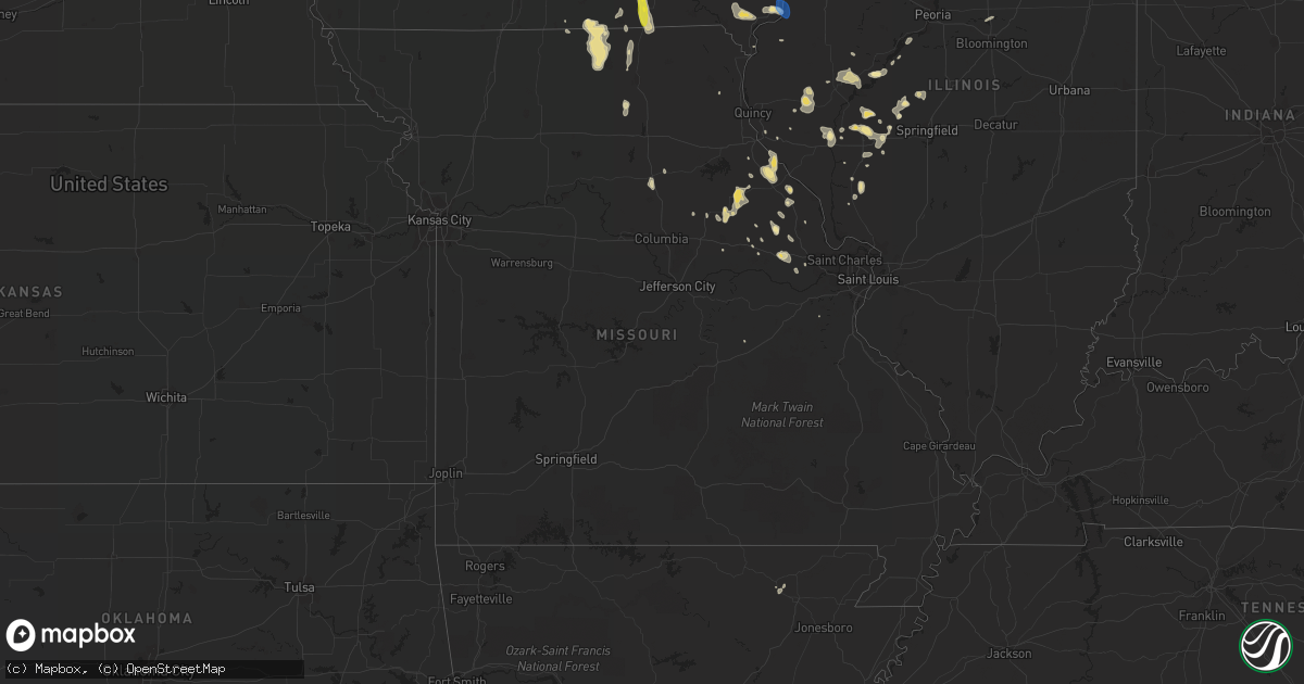
Hail Map in Missouri on June 28, 2019
Get this storm
June 28 map
$229
one time, instant access
Download today. No call, no setup
Keep the $229
Bought the map and want the full workflow? Apply the entire $229 to a subscription within 7 days. None of it is wasted.
Every map, not just this one
This buys you this map. Subscription and you get every map we run, in the markets you choose from a few cities to whole states to nationwide. Plus real-time alerts the moment a storm fires.
Contact data
Name, contact info, occupancy, even credit band for addresses in the footprint. You go from where it hit to who to call.
Become the source they trust
Unlimited branding weather history reports on demand. You already have the documented answer ready for the property owner, and you are the one who showed up with it.
Property data and RoofTrace estimates
Pull up any address you have got, its value and the exact code rules for that jurisdiction, straight from One Click Code. Then RoofTrace estimates the squares, pitch, and roof value, priced the way you price.
Storm reports in Missouri
Missouri
| Date | Description |
|---|---|
| 06/28/20195:09 PM CDT | Reported at 2545 w randolph st charles: tree branches from large tree down... Also pea sized hail. |
| 06/28/20194:46 PM CDT | Corrects previous tstm wnd dmg report from 2 ne wildwood. Reported at clayton rd and 109: power outages reported due to downed lines. |
| 06/28/20194:41 PM CDT | Corrects previous tstm wnd dmg report from 2 ne saint charles. Reported at 2545 w randolph st charles: tree branches from large tree down... Also pea sized hail. |
| 06/28/20193:30 PM CDT | Relayed report of a 100+ year old tree 2-3 ft in diameter uprooted and blown over. Hail was also reported to be a bit under golf ball size. |
| 06/28/201912:49 PM CDT | Tree branches snapped. |
| 06/28/201912:00 PM CDT | Trees and power lines down in unionville. |
| 06/28/201911:56 AM CDT | Telephone poles down. |
| 06/28/20197:29 AM CDT | At 1229 PM CDT, severe thunderstorms were located along a line extending from near Greensburg to near Greentop to near Green City, moving south at 30 mph. HAZARD...60 mph wind gusts. SOURCE...Law enforcement reported wind damage in Lancaster and Unionville over the past thirty minutes with these storms. IMPACT...Expect damage to roofs, siding, and trees. Locations impacted include... Edina, Greensburg, Plevna, Hurdland, Novelty and Baring. |
| 06/28/20197:28 AM CDT | At 1228 PM CDT, severe thunderstorms were located along a line extending from near Greensburg to near Novinger to 10 miles southwest of Unionville, moving south at 30 mph. HAZARD...60 mph wind gusts and nickel size hail. SOURCE...Radar indicated. IMPACT...Expect damage to roofs, siding, and trees. Locations impacted include... Kirksville, Milan, La Plata, Green City, Novinger, Greentop, Greencastle, Brashear, Browning, Humphreys, Gibbs, Millard, Pollock, South Gifford, Osgood, Kirksville Regional, Winigan, Reger, Lemons and Green Castle. |
| 06/28/20196:29 AM CDT | At 1128 AM CDT, severe thunderstorms were located along a line extending from near Olds to Rome to near Birmingham to near Douds, moving southeast at 20 mph. HAZARD...60 mph wind gusts and quarter size hail. SOURCE...Radar indicated. IMPACT...Hail damage to vehicles is expected. Expect wind damage to roofs, siding, and trees. Locations impacted include... Fairfield, Mount Pleasant, Keosauqua, New London, Wayland, Danville, Birmingham, Milton, Bonaparte, Salem, Libertyville, Stockport, Lockridge, Olds, Cantril, Hillsboro, St. Paul, Rome, Westwood and Mount Union. |
| 06/28/20196:20 AM CDT | At 1118 AM CDT, severe thunderstorms were located along a line extending from near Batavia to Lake Sundown to 9 miles southwest of Chariton, moving south at 25 mph. HAZARD...60 mph wind gusts and quarter size hail. SOURCE...Trained weather spotters and law enforcement have reported wind damage including trees down. IMPACT...Hail damage to vehicles is expected. Expect wind damage to roofs, siding, and trees. Locations impacted include... Centerville, Bloomfield, Corydon, Lake Sundown, Rathbun Lake, Eldon, Seymour, Moravia, Moulton, Allerton, Mystic, Cincinnati, Pulaski, Drakesville, Exline, Floris, Promise City, Unionville, Numa and Rathbun. |
| 06/27/201911:27 PM CDT | At 427 PM CDT, a severe thunderstorm was located over Innsbrook, moving southeast at 15 mph. HAZARD...60 mph wind gusts and quarter size hail. SOURCE...Radar indicated. IMPACT...Hail damage to vehicles is expected. Expect wind damage to roofs, siding, and trees. Locations impacted include... Wentzville, Warrenton, Wright City, Marthasville, Truesdale, Innsbrook, New Melle, Treloar, Flint Hill, Foristell and Holstein.This includes Interstate 70 in Missouri between exits 193 and 210. |
| 06/27/201910:00 PM CDT | At 259 AM CDT, a severe thunderstorm was located 5 miles north of Auburn, or 25 miles west of Tarkio, moving east at 20 mph. HAZARD...Half dollar size hail. SOURCE...Radar indicated. IMPACT...Damage to vehicles is expected. Locations impacted include... Auburn, Peru and Julian. |
| 06/27/20198:09 PM CDT | At 108 PM CDT, a severe thunderstorm was located 10 miles west of Atlanta, or 10 miles southwest of La Plata, moving south at 30 mph. HAZARD...60 mph wind gusts and nickel size hail. SOURCE...Radar indicated. IMPACT...Expect damage to roofs, siding, and trees. Locations impacted include... Macon, Brookfield, Marceline, La Plata, Bevier, Bucklin, Atlanta, Laclede, Callao, Linneus, Browning, New Cambria, Purdin, Jacksonville, Rothville, Elmer, Ethel, South Gifford, New Boston and Excello. |
| 06/27/20198:05 PM CDT | At 104 PM CDT, severe thunderstorms were located along a line extending from near Stronghurst to La Harpe to near Carthage, moving southeast at 35 mph. HAZARD...60 mph wind gusts and quarter size hail. SOURCE...Radar indicated. IMPACT...Hail damage to vehicles is expected. Expect wind damage to roofs, siding, and trees. Locations impacted include... Macomb, Keokuk, Carthage, Bushnell, Hamilton, Warsaw, Colchester, La Harpe, Roseville, Stronghurst, Avon, Blandinsville, Augusta, Bowen, Industry, Good Hope, Prairie City, Terre Haute, Bardolph and West Point.If you are at City of Macomb you should seek safe shelterimmediately! |
All States Impacted by Hail Map on June 28, 2019
Cities Impacted by Hail Map on June 28, 2019
- Lebanon, OH
- Morrow, OH
- Hermitage, AR
- Dike, IA
- Cedar Falls, IA
- Ten Mile, TN
- Philadelphia, TN
- Fairview, MT
- Sidney, MT
- Brockton, MT
- Roseville, MI
- Saint Clair Shores, MI
- Stephens, AR
- Rosston, AR
- Walker, LA
- Denham Springs, LA
- Eureka, SD
- Stockdale, TX
- Wolf Point, MT
- Naples, FL
- Estero, FL
- White Hall, IL
- Rockbridge, IL
- Greenfield, IL
- Wrights, IL
- Dittmer, MO
- Timewell, IL
- Lansford, ND
- Washington, AR
- Fulton, AR
- Saratoga, AR
- Ashdown, AR
- Alexander, ND
- Cartwright, ND
- Atlanta, TX
- Blakesburg, IA
- Drakesville, IA
- Unionville, IA
- Bloomfield, IA
- Arnegard, ND
- Lewistown, MT
- Stanley, ND
- Palermo, ND
- Downers Grove, IL
- Louann, AR
- Mount Holly, AR
- Magnolia, AR
- Smackover, AR
- Emerson, AR
- Camden, AR
- El Dorado, AR
- Chicago, IL
- Jesup, IA
- Fairbank, IA
- Dunkerton, IA
- Waterloo, IA
- Whitley City, KY
- Hooks, TX
- Moravia, IA
- Lancaster, MO
- Downing, MO
- Ottumwa, IA
- Albia, IA
- Madison, VA
- Texarkana, AR
- Peebles, OH
- Ross, ND
- Sterling Heights, MI
- Waverly, OH
- Malta, MT
- Zortman, MT
- Deering, ND
- Berthold, ND
- Des Lacs, ND
- Surrey, ND
- Glenburn, ND
- Minot, ND
- Carpio, ND
- Norwich, ND
- Burlington, ND
- Minot Afb, ND
- Donnybrook, ND
- White Earth, ND
- Tolley, ND
- Newport, TN
- Hurley, NM
- Kramer, ND
- Homer Glen, IL
- Huntsville, IL
- Fortuna, ND
- Pleasant Plain, OH
- Thompson, MO
- Detroit, MI
- Scobey, MT
- Englewood, FL
- Hazelton, ND
- Mandan, ND
- Zeeland, ND
- Solen, ND
- Linton, ND
- Hague, ND
- Almont, ND
- New Salem, ND
- Ashley, ND
- Strasburg, ND
- Flasher, ND
- Cannon Ball, ND
- Saint Anthony, ND
- Green Castle, MO
- Green City, MO
- Unionville, MO
- Cincinnati, IA
- Centerville, IA
- Lexington, MI
- Roodhouse, IL
- Winchester, IL
- Mills, NM
- Maxbass, ND
- Herreid, SD
- Lockport, IL
- New Edinburg, AR
- Thornton, AR
- Kingsland, AR
- Fordyce, AR
- Fouke, AR
- Houston, TX
- Two Dot, MT
- Martinsdale, MT
- Eolia, MO
- Souris, ND
- Richey, MT
- Bloomfield, MT
- Glendive, MT
- Savage, MT
- Lambert, MT
- Capitol Heights, MD
- Hyattsville, MD
- Santa Fe, TX
- Elmer, MO
- Chatham, MS
- Greenville, MS
- Hollandale, MS
- Fort Peck, MT
- Strong, AR
- Donnellson, IA
- West Point, IA
- Epping, ND
- Columbus, ND
- Moore, MT
- Hobson, MT
- Buffalo, MT
- Yale, MI
- Floresville, TX
- Willow City, ND
- Winifred, MT
- Union Church, MS
- Reserve, MT
- Redstone, MT
- Plentywood, MT
- Mertztown, PA
- Alburtis, PA
- Hohenwald, TN
- Wewahitchka, FL
- Plaza, ND
- Ashland, IL
- Vance, AL
- Olivehill, TN
- Clintwood, VA
- Clinchco, VA
- New Town, ND
- Warren, MI
- Ashburn, MO
- Louisiana, MO
- New London, MO
- Towner, ND
- New Sharon, IA
- Silex, MO
- Elsberry, MO
- Foley, MO
- Troy, MO
- Roxie, MS
- Alvin, TX
- Poteet, TX
- Bowling Green, MO
- Frankford, MO
- Poplar, MT
- Jacksonville, IL
- Murrayville, IL
- Williston, ND
- Portland, AR
- Lake Village, AR
- Keota, IA
- Sigourney, IA
- Richland, IA
- Lockridge, IA
- Brighton, IA
- Ollie, IA
- Fairfield, IA
- Mount Pleasant, IA
- Rochelle, VA
- Aroda, VA
- Benton City, MO
- Martinsburg, MO
- Boerne, TX
- Franklin, LA
- Keokee, VA
- Saint Charles, VA
- Arenzville, IL
- Concord, IL
- Chapin, IL
- Cranks, KY
- Cawood, KY
- Eubank, KY
- Chillicothe, OH
- Crewe, VA
- Havana, IL
- Topeka, IL
- Wellsville, MO
- Farber, MO
- Laddonia, MO
- Curryville, MO
- Vandalia, MO
- Saint Martinville, LA
- New Iberia, LA
- Hawk Point, MO
- Outlook, MT
- Flaxville, MT
- Oregon, WI
- Brooklyn, WI
- Morgan City, LA
- Griggsville, IL
- Meredosia, IL
- Chambersburg, IL
- Bluffs, IL
- Peerless, MT
- Grundy Center, IA
- Parkersburg, IA
- Holland, IA
- Fleetwood, PA
- Cambridge, WI
- Fort Atkinson, WI
- Grass Range, MT
- Rarden, OH
- Piketon, OH
- Dewar, IA
- Spring, TX
- Tomball, TX
- Wright City, MO
- Warrenton, MO
- Truesdale, MO
- Minor Hill, TN
- Seymour, IA
- Albany, WI
- Plain Dealing, LA
- Hinsdale, MT
- Saco, MT
- Granville, ND
- Bantry, ND
- Powers Lake, ND
- Westhope, ND
- Monroe, IA
- Reasnor, IA
- Fort Madison, IA
- Clarksville, MO
- Okeechobee, FL
- Belleville, WI
- Lenoir City, TN
- Gilman, IA
- Victoria, VA
- Roy, MT
- Hope, AR
- Ray, ND
- Attica, MI
- Capac, MI
- Imlay City, MI
- Knoxville, TN
- Carson, ND
- Terra Ceia, FL
- Faber, VA
- Nellysford, VA
- Tioga, ND
- Tallula, IL
- New Market, TN
- Dandridge, TN
- Inglis, FL
- Frazer, MT
- Larslan, MT
- Queen City, MO
- West Helena, AR
- Raymond, MT
- Steamboat Rock, IA
- Carrollton, IL
- Melbourne, IA
- Lacassine, LA
- Bell City, LA
- Astoria, IL
- Bath, IL
- Burlington, IA
- Wever, IA
- Fort Myers, FL
- North Fort Myers, FL
- Virginia, IL
- Dierks, AR
- Whitewater, WI
- Jefferson, WI
- Palmyra, WI
- New Tripoli, PA
- Manito, IL
- Bainbridge, OH
- Bokeelia, FL
- Grand Chenier, LA
- Petersburg, IL
- La Porte City, IA
- Vermont, IL
- Rushville, IL
- Browning, IL
- Perry, FL
- Warren, AR
- Kinderhook, IL
- Orange, VA
- Radiant, VA
- Beloit, WI
- Rockton, IL
- Church Road, VA
- Cape Coral, FL
- Flat Lick, KY
- Petersburg, VA
- Meherrin, VA
- Meadville, MS
- Watford City, ND
- Table Grove, IL
- Greentop, MO
- Kirksville, MO
- Novinger, MO
- Mount Sterling, IL
- Mountain City, TN
- Powell, TN
- Crab Orchard, KY
- Moberly, MO
- Upham, ND
- Lignite, ND
- Liberty, MS
- Smithdale, MS
- Harper, IA
- Salem, IA
- Packwood, IA
- Knoxville, IA
- Bussey, IA
- Moulton, IA
- Thomasville, AL
- Immokalee, FL
- Whitetail, MT
- Oley, PA
- Reading, PA
- Birdsboro, PA
- Douglassville, PA
- Deep River, IA
- Emmet, AR
- Linden, TX
- Bivins, TX
- Holtwood, PA
- Moss, TN
- Theriot, LA
- Montrose, AR
- Evansville, WI
- Janesville, WI
- Reinbeck, IA
- Harvey, IA
- Loudon, TN
- Sweetwater, TN
- Seminole, AL
- Elberta, AL
- Robertsdale, AL
- Summerdale, AL
- Mohall, ND
- Wentzville, MO
- Prospect, TN
- Lester, AL
- Panama City Beach, FL
- Melrose, FL
- Keystone Heights, FL
- Alexander, IL
- Saint Petersburg, FL
- Denver, IA
- Moundville, AL
- Hazlehurst, MS
- Creole, LA
- Lake Charles, LA
- Cameron, LA
- Westby, MT
- Saint Joseph, LA
- Eudora, AR
- Mobile, AL
- Seymour, TN
- Sevierville, TN
- Seville, OH
- Medina, OH
- Chippewa Lake, OH
- Fayetteville, OH
- Nauvoo, AL
- Carbon Hill, AL
- Bottineau, ND
- Baker, LA
- Baton Rouge, LA
- Pollock, SD
- Williamsburg, MO
- Rhoadesville, VA
- Walker, KY
- Scalf, KY
- Manchester, KY
- Wildrose, ND
- Alamo, ND
- Westlake, OH
- Huntley, IL
- Union, IL
- Toledo, IA
- Garwin, IA
- Lewisville, AR
- Afton, VA
- Roseland, VA
- Auburndale, FL
- Winter Haven, FL
- Ambrose, ND
- Dermott, AR
- Lorman, MS
- Pattison, MS
- Pequea, PA
- Drumore, PA
- Syria, VA
- Etlan, VA
- Nashua, MT
- Gladbrook, IA
- Jonesburg, MO
- Green Bay, VA
- Powersville, MO
- Makoti, ND
- Burkeville, VA
- Valley City, OH
- Grafton, OH
- Columbia Station, OH
- North Port, FL
- Hamburg, AR
- Woodstock, IL
- Marengo, IL
- Hamilton, IA
- Lovilia, IA
- Bradley, AR
- Orfordville, WI
- Winfield, IA
- Grinnell, IA
- Clayton, IL
- Pensacola, FL
- Searsboro, IA
- Delta, PA
- Clearwater, FL
- Largo, FL
- Pinellas Park, FL
- Pleasant Plains, IL
- Pocahontas, AR
- Imboden, AR
- Welch, WV
- Falls City, TX
- Clifton, TN
- Pella, IA
- Trementina, NM
- Osyka, MS
- Aplington, IA
- Clark, MO
- Eddyville, IA
- Melrose, IA
- Tuscumbia, AL
- Avoca, MI
- Emmett, MI
- Greenview, IL
- Utica, MS
- Wilmar, AR
- Patterson, LA
- Crosby, ND
- Jonesville, VA
- Pennington Gap, VA
- Kenvir, KY
- La Vernia, TX
- Front Royal, VA
- Linden, VA
- Markham, VA
- Hume, VA
- Banks, AR
- Marshalltown, IA
- Minden, LA
- Friendswood, TX
- Webster, TX
- League City, TX
- Beaver, OH
- Foristell, MO
- Marthasville, MO
- Hudson, IA
- Wayland, IA
- Livingston, LA
- Waverly, IA
- Pleasanton, TX
- Helena, AR
- Oskaloosa, IA
- Fort Kent, ME
- Newburg, ND
- Bismarck, ND
- Fort Yates, ND
- Clarksville, TN
- Noonan, ND
- Black Rock, AR
- Powhatan, AR
- Monticello, FL
- Ogden, AR
- Mineral Springs, AR
- Richland, MT
- Yankeetown, FL
- New Castle, PA
- Mount Vernon, KY
- Brodhead, KY
- Blackstone, VA
- Daphne, AL
- Loxley, AL
- Port Charlotte, FL
- El Paso, IL
- Hudson, IL
- Hilger, MT
- Kingston, TN
- Eastpointe, MI
- Edgerton, WI
- Bellflower, MO
- New Hartford, IA
- Stanford, MT
- Jackson, AL
- Texas City, TX
- Bowbells, ND
- Madison Heights, MI
- Hazel Park, MI
- Cuba, MO
- Cotton Valley, LA
- Benton, LA
- Fraser, MI
- Cottondale, AL
- West Blocton, AL
- Duncanville, AL
- Texarkana, TX
- Punta Gorda, FL
- Centreville, AL
- Brent, AL
- Woodstock, AL
- Greensboro, AL
- Augusta, ME
- Coahoma, MS
- Friars Point, MS
- East Troy, WI
- Eagle, WI
- Theodore, AL
- Hermanville, MS
- Tama, IA
- Sutherland, VA
- Edwards, MS
- Raymond, MS
- Athens, IL
- Rosharon, TX
- Tallahassee, FL
- Litchfield, OH
- Somerset, VA
- Hood, VA
- Rapidan, VA
- Stanardsville, VA
- Hampton, AR
- Westmont, IL
- Dallas City, IL
- Carthage, IL
- Forrest City, AR
- Jefferson, ME
- Albion, IA
- Batavia, IL
- Warrenville, IL
- Gloster, MS
- Greensburg, LA
- Lewistown, MO
- Vanceburg, KY
- Tollesboro, KY
- Stout, IA
- Spearsville, LA
- Dellroy, OH
- Lynnville, IA
- High Hill, MO
- Sarepta, LA
- Jeanerette, LA
- Conrad, IA
- Madison, MO
- Ebro, FL
- Allison, IA
- Kellogg, IA
- Montour, IA
- Danville, AL
- Flag Pond, TN
- Antler, ND
- Helenville, WI
- Corydon, IA
- Martinsville, OH
- Fayette, MS
- Beaman, IA
- Richmond Dale, OH
- Antelope, MT
- Kenmare, ND
- Bloomburg, TX
- Queen City, TX
- Doddridge, AR
- Greenwell Springs, LA
- Clarksville, IA
- Clutier, IA
- Traer, IA
- Verona, WI
- Arena, WI
- Spring Green, WI
- Glasgow, MT
- Velva, ND
- Lemont, IL
- Lodi, OH
- Rolling Fork, MS
- Mayersville, MS
- Franklin, IL
- New Florence, MO
- Montgomery City, MO
- Strunk, KY
- Brodhead, WI
- Haverhill, IA
- Laurel, IA
- Taylor, AR
- Springhill, LA
- Sibley, LA
- Mount Clemens, MI
- Clinton Township, MI
- Sauk City, WI
- Crane, MT
- Jewell, IA
- Wapello, IA
- La Plata, MO
- Keene, ND
- Mckeesport, PA
- Martinsville, VA
- Liberty, IL
- Coatsville, MO
- Shell Rock, IA
- Morning Sun, IA
- Savannah, TN
- Janesville, IA
- Payson, IL
- Hull, IL
- Denton, MT
- Hazard, KY
- Mexico, MO
- Haughton, LA
- Von Ormy, TX
- Axton, VA
- Callands, VA
- Westlake, LA
- Iowa, LA
- Willowbrook, IL
- Darien, IL
- La Grange, IL
- Bridgeview, IL
- Willow Springs, IL
- Hickory Hills, IL
- Justice, IL
- Glenwood, MO
- Oregonia, OH
- New Glarus, WI
- Monticello, WI
- Keokuk, IA
- Bechtelsville, PA
- Barto, PA
- Philadelphia, PA
- Newton, IA
- Maud, TX
- Boyertown, PA
- Newark, DE
- Scott, LA
- Church Point, LA
- Orland Park, IL
- Collegeville, PA
- Zap, ND
- Richardton, ND
- Hebron, ND
- Halliday, ND
- Dunn Center, ND
- Dodge, ND
- Beulah, ND
- Glen Ullin, ND
- Taylor, ND
- Barberton, OH
- Wadsworth, OH
- Carman, IL
- Lomax, IL
- Saint Marie, MT
- Vandalia, MT
- Rolette, ND


