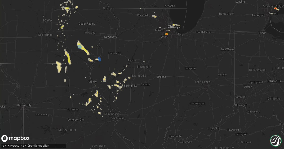
Hail Map in Illinois on June 28, 2019
Get this storm
June 28 map
$229
one time, instant access
Download today. No call, no setup
Keep the $229
Bought the map and want the full workflow? Apply the entire $229 to a subscription within 7 days. None of it is wasted.
Every map, not just this one
This buys you this map. Subscription and you get every map we run, in the markets you choose from a few cities to whole states to nationwide. Plus real-time alerts the moment a storm fires.
Contact data
Name, contact info, occupancy, even credit band for addresses in the footprint. You go from where it hit to who to call.
Become the source they trust
Unlimited branding weather history reports on demand. You already have the documented answer ready for the property owner, and you are the one who showed up with it.
Property data and RoofTrace estimates
Pull up any address you have got, its value and the exact code rules for that jurisdiction, straight from One Click Code. Then RoofTrace estimates the squares, pitch, and roof value, priced the way you price.
Storm reports in Illinois
Illinois
| Date | Description |
|---|---|
| 06/28/20196:50 PM CDT | Report received via social media. |
| 06/28/20196:50 PM CDT | Report received via social media. |
| 06/28/20196:14 PM CDT | A local report indicates 1.00 inch wind near 3 NE LOCKPORT |
| 06/28/20196:13 PM CDT | A local report indicates 1.75 inch wind near 2 SE LEMONT |
| 06/28/20196:12 PM CDT | Reported at 14600 127th st... Lemont... Il 60439. |
| 06/28/20196:09 PM CDT | A local report indicates 1.75 inch wind near 2 N HOMER GLEN |
| 06/28/20196:04 PM CDT | Report received via social media. |
| 06/28/20193:09 PM CDT | Power lines reported down in town. |
| 06/28/201912:54 PM CDT | Portion of a garage roof blown off and shed window blown out. |
| 06/28/201912:53 PM CDT | Large tree down. Time estimated from radar. |
| 06/28/201912:53 PM CDT | Large tree down. Time estimated by radar. |
| 06/28/20193:59 AM CDT | At 858 AM CDT, a severe thunderstorm was located over Marengo, moving east at 25 mph. HAZARD...60 mph wind gusts and quarter size hail. SOURCE...Radar indicated. IMPACT...Hail damage to vehicles is expected. Expect wind damage to roofs, siding, and trees. Locations impacted include... Carpentersville, Algonquin, McHenry, Woodstock, Marengo, Wonder Lake, Lake In The Hills, Huntley, Hampshire, Lakewood, Prairie Grove, Bull Valley, Trout Valley, Greenwood, Crystal Lake, Cary, Barrington Hills and Union.Including the following interstate... I-90 between mile markers 36 and 45. This includes... Mchenry County College and Mchenry CountyFairgrounds. |
| 06/28/20191:48 AM CDT | At 647 PM CDT, a severe thunderstorm was located over Lakeview, or over Lincoln Park, and is nearly stationary. HAZARD...Quarter size hail. SOURCE...Radar indicated. IMPACT...Damage to vehicles is expected. Locations impacted include... Chicago, Cicero, Berwyn, Oak Park, Harwood Heights, Northerly Island, Lincoln Park, Navy Pier, Lakeview, Humboldt Park, Rogers Park, Logan Square, Douglas Park and Lincolnwood.Including the following interstates... I-55 between mile markers 291 and 294. I-94 between mile markers 41 and 55. I-290 between mile markers 23 and 29. I-294 between mile markers 41 and 55.This includes... Lincoln Park Zoo, Loyola University, NortheasternIllinois University, Soldier Field, University of Illinois Chicago,Wrigley Field, The Loop, Museum Campus, and Northerly Island. |
| 06/28/201912:51 AM CDT | At 550 PM CDT, a severe thunderstorm was located over Lockport, or near Homer Glen, moving east at 10 mph. HAZARD...60 mph wind gusts and quarter size hail. SOURCE...Radar indicated. IMPACT...Hail damage to vehicles is expected. Expect wind damage to roofs, siding, and trees. Locations impacted include... Joliet, Orland Park, Tinley Park, Romeoville, Lockport, New Lenox, Homer Glen, Mokena, Frankfort, Lemont, Worth, Ingalls Park, Palos Hills, Hickory Hills, Goodings Grove, Crest Hill, Bridgeview, Palos Heights, Orland Hills and Palos Park.Including the following interstates... I-80 between mile markers 138 and 149. I-355 between mile markers 1 and 9.This includes... University of St. Francis, Lewis University, andMoraine Valley Community College. |
| 06/27/201910:51 PM CDT | At 349 PM CDT, a severe thunderstorm was located near Greenfield, moving south at 20 mph. HAZARD...60 mph wind gusts and quarter size hail. SOURCE...Radar indicated. IMPACT...Hail damage to vehicles is expected. Expect wind damage to roofs, siding, and trees. Locations impacted include... Carrollton, Greenfield, Athensville, Kane, Wrights and Rockbridge. |
| 06/27/201910:14 PM CDT | At 313 PM CDT, severe thunderstorms were located along a line extending from near Louisiana to near Farber, moving south at 20 mph. HAZARD...60 mph wind gusts and quarter size hail. SOURCE...Radar indicated. IMPACT...Hail damage to vehicles is expected. Expect wind damage to roofs, siding, and trees. Locations impacted include... Bowling Green, Vandalia, Louisiana, Wellsville, Eolia, Clarksville, Farber, Curryville, Tarrants, Buell, New Hartford, Silex, Middletown, Paynesville, Whiteside, Annada, Edgewood, St. Clement, Olney and Cyrene. |
| 06/27/201910:13 PM CDT | At 312 PM CDT, a severe thunderstorm was located near Jacksonville, moving east at 45 mph. HAZARD...60 mph wind gusts and nickel size hail. SOURCE...Radar indicated. IMPACT...Expect damage to roofs, siding, and trees. Locations impacted include... Springfield, Jacksonville, Chatham, Alexander, Auburn, Rochester, Pawnee, New Berlin, Waverly, Divernon, Loami, Franklin, Literberry, South Jacksonville, Jerome, Southern View, Thayer, Berry, Curran and Berlin.This includes the following highways... Interstate 55 between mile markers 77 and 93. Interstate 72 between mile markers 68 and 100. |
| 06/27/20199:44 PM CDT | At 244 PM CDT, a severe thunderstorm was located over Naples, moving southeast at 20 mph. HAZARD...60 mph wind gusts and quarter size hail. SOURCE...Radar indicated. IMPACT...Hail damage to vehicles is expected. Expect wind damage to roofs, siding, and trees. Locations impacted include... Montezuma, Milton, Chambersburg, Detroit, Florence and Valley City. |
| 06/27/20199:39 PM CDT | At 239 PM CDT, a severe thunderstorm was located over Naples, or 10 miles northwest of Winchester, moving southeast at 30 mph. HAZARD...60 mph wind gusts and penny size hail. SOURCE...Radar indicated. IMPACT...Expect damage to roofs, siding, and trees. Locations impacted include... Jacksonville, Winchester, Meredosia, Bluffs, Murrayville, Chapin, Woodson, Manchester, Alsey, Naples, Exeter, South Jacksonville, Glasgow, Lynnville, Valley City, Riggston, Merritt, Oxville, Nortonville and Lake Jacksonville.This includes Interstate 72 between mile markers 43 and 68. |
| 06/27/20199:36 PM CDT | At 235 PM CDT, severe thunderstorms were located along a line extending from 7 miles northwest of Pike to Spencerburg, moving southeast at 10 mph. HAZARD...60 mph wind gusts and quarter size hail. SOURCE...Radar indicated. IMPACT...Hail damage to vehicles is expected. Expect wind damage to roofs, siding, and trees. Locations impacted include... Bowling Green, Louisiana, Clarksville, Curryville, Tarrants, Spencerburg and St. Clement. |
| 06/27/20199:19 PM CDT | At 219 PM CDT, a severe thunderstorm was located near Astoria, or 13 miles northeast of Beardstown, moving east at 35 mph. HAZARD...60 mph wind gusts and penny size hail. SOURCE...Radar indicated. IMPACT...Expect damage to roofs, siding, and trees. Locations impacted include... Astoria, Chandlerville, Bath, Kilbourne, Browning, Marbletown, Bluff City and Snicarte. |
| 06/27/20199:05 PM CDT | At 205 PM CDT, severe thunderstorms were located along a line extending from 9 miles southwest of Rushville to near Mount Sterling to Buckhorn to near Beverly, moving southeast at 15 mph. HAZARD...60 mph wind gusts and penny size hail. SOURCE...Radar indicated. IMPACT...Expect damage to roofs, siding, and trees. Locations impacted include... Mount Sterling, Griggsville, Naples, Buckhorn, La Grange, Versailles, Perry, Chambersburg, Ripley, Fishhook and Coopertown. |
All States Impacted by Hail Map on June 28, 2019
Cities Impacted by Hail Map on June 28, 2019
- Lebanon, OH
- Morrow, OH
- Hermitage, AR
- Dike, IA
- Cedar Falls, IA
- Ten Mile, TN
- Philadelphia, TN
- Fairview, MT
- Sidney, MT
- Brockton, MT
- Roseville, MI
- Saint Clair Shores, MI
- Stephens, AR
- Rosston, AR
- Walker, LA
- Denham Springs, LA
- Eureka, SD
- Stockdale, TX
- Wolf Point, MT
- Naples, FL
- Estero, FL
- White Hall, IL
- Rockbridge, IL
- Greenfield, IL
- Wrights, IL
- Dittmer, MO
- Timewell, IL
- Lansford, ND
- Washington, AR
- Fulton, AR
- Saratoga, AR
- Ashdown, AR
- Alexander, ND
- Cartwright, ND
- Atlanta, TX
- Blakesburg, IA
- Drakesville, IA
- Unionville, IA
- Bloomfield, IA
- Arnegard, ND
- Lewistown, MT
- Stanley, ND
- Palermo, ND
- Downers Grove, IL
- Louann, AR
- Mount Holly, AR
- Magnolia, AR
- Smackover, AR
- Emerson, AR
- Camden, AR
- El Dorado, AR
- Chicago, IL
- Jesup, IA
- Fairbank, IA
- Dunkerton, IA
- Waterloo, IA
- Whitley City, KY
- Hooks, TX
- Moravia, IA
- Lancaster, MO
- Downing, MO
- Ottumwa, IA
- Albia, IA
- Madison, VA
- Texarkana, AR
- Peebles, OH
- Ross, ND
- Sterling Heights, MI
- Waverly, OH
- Malta, MT
- Zortman, MT
- Deering, ND
- Berthold, ND
- Des Lacs, ND
- Surrey, ND
- Glenburn, ND
- Minot, ND
- Carpio, ND
- Norwich, ND
- Burlington, ND
- Minot Afb, ND
- Donnybrook, ND
- White Earth, ND
- Tolley, ND
- Newport, TN
- Hurley, NM
- Kramer, ND
- Homer Glen, IL
- Huntsville, IL
- Fortuna, ND
- Pleasant Plain, OH
- Thompson, MO
- Detroit, MI
- Scobey, MT
- Englewood, FL
- Hazelton, ND
- Mandan, ND
- Zeeland, ND
- Solen, ND
- Linton, ND
- Hague, ND
- Almont, ND
- New Salem, ND
- Ashley, ND
- Strasburg, ND
- Flasher, ND
- Cannon Ball, ND
- Saint Anthony, ND
- Green Castle, MO
- Green City, MO
- Unionville, MO
- Cincinnati, IA
- Centerville, IA
- Lexington, MI
- Roodhouse, IL
- Winchester, IL
- Mills, NM
- Maxbass, ND
- Herreid, SD
- Lockport, IL
- New Edinburg, AR
- Thornton, AR
- Kingsland, AR
- Fordyce, AR
- Fouke, AR
- Houston, TX
- Two Dot, MT
- Martinsdale, MT
- Eolia, MO
- Souris, ND
- Richey, MT
- Bloomfield, MT
- Glendive, MT
- Savage, MT
- Lambert, MT
- Capitol Heights, MD
- Hyattsville, MD
- Santa Fe, TX
- Elmer, MO
- Chatham, MS
- Greenville, MS
- Hollandale, MS
- Fort Peck, MT
- Strong, AR
- Donnellson, IA
- West Point, IA
- Epping, ND
- Columbus, ND
- Moore, MT
- Hobson, MT
- Buffalo, MT
- Yale, MI
- Floresville, TX
- Willow City, ND
- Winifred, MT
- Union Church, MS
- Reserve, MT
- Redstone, MT
- Plentywood, MT
- Mertztown, PA
- Alburtis, PA
- Hohenwald, TN
- Wewahitchka, FL
- Plaza, ND
- Ashland, IL
- Vance, AL
- Olivehill, TN
- Clintwood, VA
- Clinchco, VA
- New Town, ND
- Warren, MI
- Ashburn, MO
- Louisiana, MO
- New London, MO
- Towner, ND
- New Sharon, IA
- Silex, MO
- Elsberry, MO
- Foley, MO
- Troy, MO
- Roxie, MS
- Alvin, TX
- Poteet, TX
- Bowling Green, MO
- Frankford, MO
- Poplar, MT
- Jacksonville, IL
- Murrayville, IL
- Williston, ND
- Portland, AR
- Lake Village, AR
- Keota, IA
- Sigourney, IA
- Richland, IA
- Lockridge, IA
- Brighton, IA
- Ollie, IA
- Fairfield, IA
- Mount Pleasant, IA
- Rochelle, VA
- Aroda, VA
- Benton City, MO
- Martinsburg, MO
- Boerne, TX
- Franklin, LA
- Keokee, VA
- Saint Charles, VA
- Arenzville, IL
- Concord, IL
- Chapin, IL
- Cranks, KY
- Cawood, KY
- Eubank, KY
- Chillicothe, OH
- Crewe, VA
- Havana, IL
- Topeka, IL
- Wellsville, MO
- Farber, MO
- Laddonia, MO
- Curryville, MO
- Vandalia, MO
- Saint Martinville, LA
- New Iberia, LA
- Hawk Point, MO
- Outlook, MT
- Flaxville, MT
- Oregon, WI
- Brooklyn, WI
- Morgan City, LA
- Griggsville, IL
- Meredosia, IL
- Chambersburg, IL
- Bluffs, IL
- Peerless, MT
- Grundy Center, IA
- Parkersburg, IA
- Holland, IA
- Fleetwood, PA
- Cambridge, WI
- Fort Atkinson, WI
- Grass Range, MT
- Rarden, OH
- Piketon, OH
- Dewar, IA
- Spring, TX
- Tomball, TX
- Wright City, MO
- Warrenton, MO
- Truesdale, MO
- Minor Hill, TN
- Seymour, IA
- Albany, WI
- Plain Dealing, LA
- Hinsdale, MT
- Saco, MT
- Granville, ND
- Bantry, ND
- Powers Lake, ND
- Westhope, ND
- Monroe, IA
- Reasnor, IA
- Fort Madison, IA
- Clarksville, MO
- Okeechobee, FL
- Belleville, WI
- Lenoir City, TN
- Gilman, IA
- Victoria, VA
- Roy, MT
- Hope, AR
- Ray, ND
- Attica, MI
- Capac, MI
- Imlay City, MI
- Knoxville, TN
- Carson, ND
- Terra Ceia, FL
- Faber, VA
- Nellysford, VA
- Tioga, ND
- Tallula, IL
- New Market, TN
- Dandridge, TN
- Inglis, FL
- Frazer, MT
- Larslan, MT
- Queen City, MO
- West Helena, AR
- Raymond, MT
- Steamboat Rock, IA
- Carrollton, IL
- Melbourne, IA
- Lacassine, LA
- Bell City, LA
- Astoria, IL
- Bath, IL
- Burlington, IA
- Wever, IA
- Fort Myers, FL
- North Fort Myers, FL
- Virginia, IL
- Dierks, AR
- Whitewater, WI
- Jefferson, WI
- Palmyra, WI
- New Tripoli, PA
- Manito, IL
- Bainbridge, OH
- Bokeelia, FL
- Grand Chenier, LA
- Petersburg, IL
- La Porte City, IA
- Vermont, IL
- Rushville, IL
- Browning, IL
- Perry, FL
- Warren, AR
- Kinderhook, IL
- Orange, VA
- Radiant, VA
- Beloit, WI
- Rockton, IL
- Church Road, VA
- Cape Coral, FL
- Flat Lick, KY
- Petersburg, VA
- Meherrin, VA
- Meadville, MS
- Watford City, ND
- Table Grove, IL
- Greentop, MO
- Kirksville, MO
- Novinger, MO
- Mount Sterling, IL
- Mountain City, TN
- Powell, TN
- Crab Orchard, KY
- Moberly, MO
- Upham, ND
- Lignite, ND
- Liberty, MS
- Smithdale, MS
- Harper, IA
- Salem, IA
- Packwood, IA
- Knoxville, IA
- Bussey, IA
- Moulton, IA
- Thomasville, AL
- Immokalee, FL
- Whitetail, MT
- Oley, PA
- Reading, PA
- Birdsboro, PA
- Douglassville, PA
- Deep River, IA
- Emmet, AR
- Linden, TX
- Bivins, TX
- Holtwood, PA
- Moss, TN
- Theriot, LA
- Montrose, AR
- Evansville, WI
- Janesville, WI
- Reinbeck, IA
- Harvey, IA
- Loudon, TN
- Sweetwater, TN
- Seminole, AL
- Elberta, AL
- Robertsdale, AL
- Summerdale, AL
- Mohall, ND
- Wentzville, MO
- Prospect, TN
- Lester, AL
- Panama City Beach, FL
- Melrose, FL
- Keystone Heights, FL
- Alexander, IL
- Saint Petersburg, FL
- Denver, IA
- Moundville, AL
- Hazlehurst, MS
- Creole, LA
- Lake Charles, LA
- Cameron, LA
- Westby, MT
- Saint Joseph, LA
- Eudora, AR
- Mobile, AL
- Seymour, TN
- Sevierville, TN
- Seville, OH
- Medina, OH
- Chippewa Lake, OH
- Fayetteville, OH
- Nauvoo, AL
- Carbon Hill, AL
- Bottineau, ND
- Baker, LA
- Baton Rouge, LA
- Pollock, SD
- Williamsburg, MO
- Rhoadesville, VA
- Walker, KY
- Scalf, KY
- Manchester, KY
- Wildrose, ND
- Alamo, ND
- Westlake, OH
- Huntley, IL
- Union, IL
- Toledo, IA
- Garwin, IA
- Lewisville, AR
- Afton, VA
- Roseland, VA
- Auburndale, FL
- Winter Haven, FL
- Ambrose, ND
- Dermott, AR
- Lorman, MS
- Pattison, MS
- Pequea, PA
- Drumore, PA
- Syria, VA
- Etlan, VA
- Nashua, MT
- Gladbrook, IA
- Jonesburg, MO
- Green Bay, VA
- Powersville, MO
- Makoti, ND
- Burkeville, VA
- Valley City, OH
- Grafton, OH
- Columbia Station, OH
- North Port, FL
- Hamburg, AR
- Woodstock, IL
- Marengo, IL
- Hamilton, IA
- Lovilia, IA
- Bradley, AR
- Orfordville, WI
- Winfield, IA
- Grinnell, IA
- Clayton, IL
- Pensacola, FL
- Searsboro, IA
- Delta, PA
- Clearwater, FL
- Largo, FL
- Pinellas Park, FL
- Pleasant Plains, IL
- Pocahontas, AR
- Imboden, AR
- Welch, WV
- Falls City, TX
- Clifton, TN
- Pella, IA
- Trementina, NM
- Osyka, MS
- Aplington, IA
- Clark, MO
- Eddyville, IA
- Melrose, IA
- Tuscumbia, AL
- Avoca, MI
- Emmett, MI
- Greenview, IL
- Utica, MS
- Wilmar, AR
- Patterson, LA
- Crosby, ND
- Jonesville, VA
- Pennington Gap, VA
- Kenvir, KY
- La Vernia, TX
- Front Royal, VA
- Linden, VA
- Markham, VA
- Hume, VA
- Banks, AR
- Marshalltown, IA
- Minden, LA
- Friendswood, TX
- Webster, TX
- League City, TX
- Beaver, OH
- Foristell, MO
- Marthasville, MO
- Hudson, IA
- Wayland, IA
- Livingston, LA
- Waverly, IA
- Pleasanton, TX
- Helena, AR
- Oskaloosa, IA
- Fort Kent, ME
- Newburg, ND
- Bismarck, ND
- Fort Yates, ND
- Clarksville, TN
- Noonan, ND
- Black Rock, AR
- Powhatan, AR
- Monticello, FL
- Ogden, AR
- Mineral Springs, AR
- Richland, MT
- Yankeetown, FL
- New Castle, PA
- Mount Vernon, KY
- Brodhead, KY
- Blackstone, VA
- Daphne, AL
- Loxley, AL
- Port Charlotte, FL
- El Paso, IL
- Hudson, IL
- Hilger, MT
- Kingston, TN
- Eastpointe, MI
- Edgerton, WI
- Bellflower, MO
- New Hartford, IA
- Stanford, MT
- Jackson, AL
- Texas City, TX
- Bowbells, ND
- Madison Heights, MI
- Hazel Park, MI
- Cuba, MO
- Cotton Valley, LA
- Benton, LA
- Fraser, MI
- Cottondale, AL
- West Blocton, AL
- Duncanville, AL
- Texarkana, TX
- Punta Gorda, FL
- Centreville, AL
- Brent, AL
- Woodstock, AL
- Greensboro, AL
- Augusta, ME
- Coahoma, MS
- Friars Point, MS
- East Troy, WI
- Eagle, WI
- Theodore, AL
- Hermanville, MS
- Tama, IA
- Sutherland, VA
- Edwards, MS
- Raymond, MS
- Athens, IL
- Rosharon, TX
- Tallahassee, FL
- Litchfield, OH
- Somerset, VA
- Hood, VA
- Rapidan, VA
- Stanardsville, VA
- Hampton, AR
- Westmont, IL
- Dallas City, IL
- Carthage, IL
- Forrest City, AR
- Jefferson, ME
- Albion, IA
- Batavia, IL
- Warrenville, IL
- Gloster, MS
- Greensburg, LA
- Lewistown, MO
- Vanceburg, KY
- Tollesboro, KY
- Stout, IA
- Spearsville, LA
- Dellroy, OH
- Lynnville, IA
- High Hill, MO
- Sarepta, LA
- Jeanerette, LA
- Conrad, IA
- Madison, MO
- Ebro, FL
- Allison, IA
- Kellogg, IA
- Montour, IA
- Danville, AL
- Flag Pond, TN
- Antler, ND
- Helenville, WI
- Corydon, IA
- Martinsville, OH
- Fayette, MS
- Beaman, IA
- Richmond Dale, OH
- Antelope, MT
- Kenmare, ND
- Bloomburg, TX
- Queen City, TX
- Doddridge, AR
- Greenwell Springs, LA
- Clarksville, IA
- Clutier, IA
- Traer, IA
- Verona, WI
- Arena, WI
- Spring Green, WI
- Glasgow, MT
- Velva, ND
- Lemont, IL
- Lodi, OH
- Rolling Fork, MS
- Mayersville, MS
- Franklin, IL
- New Florence, MO
- Montgomery City, MO
- Strunk, KY
- Brodhead, WI
- Haverhill, IA
- Laurel, IA
- Taylor, AR
- Springhill, LA
- Sibley, LA
- Mount Clemens, MI
- Clinton Township, MI
- Sauk City, WI
- Crane, MT
- Jewell, IA
- Wapello, IA
- La Plata, MO
- Keene, ND
- Mckeesport, PA
- Martinsville, VA
- Liberty, IL
- Coatsville, MO
- Shell Rock, IA
- Morning Sun, IA
- Savannah, TN
- Janesville, IA
- Payson, IL
- Hull, IL
- Denton, MT
- Hazard, KY
- Mexico, MO
- Haughton, LA
- Von Ormy, TX
- Axton, VA
- Callands, VA
- Westlake, LA
- Iowa, LA
- Willowbrook, IL
- Darien, IL
- La Grange, IL
- Bridgeview, IL
- Willow Springs, IL
- Hickory Hills, IL
- Justice, IL
- Glenwood, MO
- Oregonia, OH
- New Glarus, WI
- Monticello, WI
- Keokuk, IA
- Bechtelsville, PA
- Barto, PA
- Philadelphia, PA
- Newton, IA
- Maud, TX
- Boyertown, PA
- Newark, DE
- Scott, LA
- Church Point, LA
- Orland Park, IL
- Collegeville, PA
- Zap, ND
- Richardton, ND
- Hebron, ND
- Halliday, ND
- Dunn Center, ND
- Dodge, ND
- Beulah, ND
- Glen Ullin, ND
- Taylor, ND
- Barberton, OH
- Wadsworth, OH
- Carman, IL
- Lomax, IL
- Saint Marie, MT
- Vandalia, MT
- Rolette, ND


