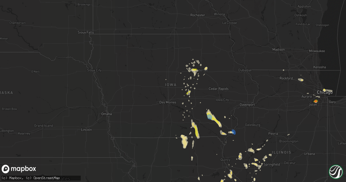
Hail Map in Iowa on June 28, 2019
Get this storm
June 28 map
$229
one time, instant access
Download today. No call, no setup
Keep the $229
Bought the map and want the full workflow? Apply the entire $229 to a subscription within 7 days. None of it is wasted.
Every map, not just this one
This buys you this map. Subscription and you get every map we run, in the markets you choose from a few cities to whole states to nationwide. Plus real-time alerts the moment a storm fires.
Contact data
Name, contact info, occupancy, even credit band for addresses in the footprint. You go from where it hit to who to call.
Become the source they trust
Unlimited branding weather history reports on demand. You already have the documented answer ready for the property owner, and you are the one who showed up with it.
Property data and RoofTrace estimates
Pull up any address you have got, its value and the exact code rules for that jurisdiction, straight from One Click Code. Then RoofTrace estimates the squares, pitch, and roof value, priced the way you price.
Storm reports in Iowa
Iowa
| Date | Description |
|---|---|
| 06/28/201912:57 PM CDT | A local report indicates 70 MPH wind near 1 E BURLINGTON REGIONAL |
| 06/28/201912:52 PM CDT | Estimated winds 55 to 60 mph. Possibly higher. |
| 06/28/201912:03 PM CDT | Spotter reports 6 to 8 inch tree limbs have been snapped. Damage to a residential roof in town. |
| 06/28/201911:55 AM CDT | Sheriffs office received call of trees down in mount pleasant. Time estimated. |
| 06/28/201911:51 AM CDT | Gusty winds were bending small... Weak trees completely over. Bigger trees had 2 to 3 inch diameter branches broken off. Small hail was occurring but appeared to be les |
| 06/28/201911:50 AM CDT | Quarter sized hail and heavy rainfall. |
| 06/28/201911:30 AM CDT | Us army corps of engineers reports large branches down in campground near rathbun lake. |
| 06/28/201911:20 AM CDT | Report of large branches down on the west side of ottumwa. |
| 06/28/201911:13 AM CDT | Social media report of trees down in albia. |
| 06/28/201911:10 AM CDT | Trees and power lines down on railroad street. |
| 06/28/201911:06 AM CDT | Roof damage to buildings. Siding damage to buildings. Multiple maple trees with limbs 10 to 12 inches in diameter down. Winds went through center of town... Tree damage |
| 06/28/201911:05 AM CDT | Appanoose county dispatch is reporting trees down and building damage in moravia. |
| 06/28/201910:52 AM CDT | Report at the otm airport asos. Sustained wind of 41 mph. |
| 06/28/201910:51 AM CDT | Several trees down across the city of eddyville. Utility pole snapped. Two houses had trees that fell on top of them. Unknown damage to houses. Delayed report and time |
| 06/28/201910:50 AM CDT | Corn flattened. Time estimated from radar. |
| 06/28/201910:45 AM CDT | Trees down. Time estimated from radar. |
| 06/28/201910:42 AM CDT | Delayed report. Numerous trees and branches down in city of packwood. Time estimated based on radar. |
| 06/28/201910:40 AM CDT | Report from mping. Large tree 2 to 3 foot diameter snapped in the city central square. |
| 06/28/201910:40 AM CDT | Tree down across 320th street. Time estimated from radar. |
| 06/28/201910:36 AM CDT | Trees down. Time estimated from radar. |
| 06/28/201910:30 AM CDT | Report from kniakrls radio via social media. Large tree snapped in town. Delayed report... Time estimated. |
| 06/28/20199:29 AM CDT | Mping report. |
| 06/28/20199:22 AM CDT | Social media picture. |
| 06/28/20197:58 AM CDT | Mping report. |
| 06/28/20197:29 AM CDT | At 1228 PM CDT, severe thunderstorms were located along a line extending from near West Burlington to near Denmark to New Boston, moving east southeast at 35 mph. HAZARD...60 mph wind gusts and quarter size hail. SOURCE...Radar indicated. IMPACT...Hail damage to vehicles is expected. Expect wind damage to roofs, siding, and trees. Locations impacted include... Burlington, Fort Madison, Carthage, Nauvoo, West Burlington, La Harpe, West Point, Dallas City, Danville, Donnellson, Montrose, Stronghurst, Middletown, Carman, Terre Haute, Ferris, Franklin, Gulf Port, Colusa and Niota. |
| 06/28/20197:25 AM CDT | Barn... Silo... And power lines damaged at 2526 51st street drive about 3 miles south of brandon... Ia. Time estimated. |
| 06/28/20197:25 AM CDT | Barn destroyed at highway 218 and 52nd street. Road had to be closed to clear some debris off of highway. Time estimated. |
| 06/28/20197:07 AM CDT | At 1206 PM CDT, severe thunderstorms were located along a line extending from Milton to near Lancaster, moving south at 35 mph. HAZARD...60 mph wind gusts. SOURCE...Radar indicated. IMPACT...Expect damage to roofs, siding, and trees. Locations impacted include... Memphis, Greensburg, Crawford, Bible Grove, Hitt, Memphis Memorial Airport, Scotland County Fairgrounds, Spillman Mound and Kilwinning. |
| 06/28/20196:24 AM CDT | At 1123 AM CDT, severe thunderstorms were located along a line extending from near Leon to 10 miles southwest of Centerville to 7 miles southwest of Milton, moving south at 30 mph. HAZARD...60 mph wind gusts. SOURCE...Radar indicated. IMPACT...Expect damage to roofs, siding, and trees. Locations impacted include... Kirksville, Milan, Unionville, Lancaster, Princeton, Green City, Queen City, Ridgeway, Novinger, Greentop, Downing, Mercer, Cainsville, Greencastle, Brashear, Spickard, Lineville, Glenwood, Blythedale and Newtown. |
| 06/28/20196:07 AM CDT | At 1107 AM CDT, severe thunderstorms were located along a line extending from 7 miles north of Rathbun Lake to near Chariton, moving south at 30 mph. HAZARD...60 mph wind gusts and quarter size hail. SOURCE...Radar indicated. IMPACT...Hail damage to vehicles is expected. Expect wind damage to roofs, siding, and trees. Locations impacted include... Centerville, Corydon, Rathbun Lake, Seymour, Russell, Allerton, Mystic, Melrose, Promise City, Numa, Rathbun, Plano, Millerton, Red Haw Lake State Park, Honey Creek State Park and Centerville Municipal Airport. |
| 06/28/20195:59 AM CDT | At 1058 AM CDT, severe thunderstorms were located along a line extending from near Hedrick to near Albia, moving south at 30 mph. HAZARD...60 mph wind gusts and quarter size hail. SOURCE...Airport observations from Ottumwa reported 61 mph wind gusts. IMPACT...Hail damage to vehicles is expected. Expect wind damage to roofs, siding, and trees. Locations impacted include... Ottumwa, Centerville, Albia, Eddyville, Ottumwa Industrial Airport, Lake Sundown, Rathbun Lake, Eldon, Fremont, Moravia, Agency, Lovilia, Blakesburg, Drakesville, Kirkville, Floris, Unionville, Chillicothe, Udell and Albia Municipal Airport. |
| 06/28/20195:35 AM CDT | At 1035 AM CDT, severe thunderstorms were located along a line extending from 6 miles east of Harper to near Richland to Abingdon, moving southeast at 25 mph. HAZARD...60 mph wind gusts and quarter size hail. SOURCE...Radar indicated. IMPACT...Hail damage to vehicles is expected. Expect wind damage to roofs, siding, and trees. Locations impacted include... Fairfield, Washington, Wayland, Brighton, Richland, Batavia, Libertyville, Lockridge, Crawfordsville, Maharishi Vedic City, Packwood, Rome, Harper, Pleasant Plain, Kinross, Coppock, Abingdon, Keota, Ollie and West Chester. |
| 06/28/20194:22 AM CDT | At 922 AM CDT, a severe thunderstorm was located near Grinnell, moving southeast at 40 mph. HAZARD...60 mph wind gusts and quarter size hail. SOURCE...Radar indicated. IMPACT...Hail damage to vehicles is expected. Expect wind damage to roofs, siding, and trees. Locations impacted include... Grinnell, Rock Creek Lake, Lynnville, Malcom, Oakland Acres, Grinnell Regional Airport and Rock Creek State Park.This includes Interstate 80 between mile markers 175 and 192. |
| 06/28/20192:50 AM CDT | At 750 PM CDT, a severe thunderstorm was located over Winfield, or 8 miles south of Columbus Junction, moving south at 20 mph. HAZARD...60 mph wind gusts and quarter size hail. SOURCE...Radar indicated. IMPACT...Hail damage to vehicles is expected. Expect wind damage to roofs, siding, and trees. Locations impacted include... Winfield, Mount Union, Wyman, Cairo, Virginia Grove Recreation Area, Marsh and Yarmouth. |
All States Impacted by Hail Map on June 28, 2019
Cities Impacted by Hail Map on June 28, 2019
- Lebanon, OH
- Morrow, OH
- Hermitage, AR
- Dike, IA
- Cedar Falls, IA
- Ten Mile, TN
- Philadelphia, TN
- Fairview, MT
- Sidney, MT
- Brockton, MT
- Roseville, MI
- Saint Clair Shores, MI
- Stephens, AR
- Rosston, AR
- Walker, LA
- Denham Springs, LA
- Eureka, SD
- Stockdale, TX
- Wolf Point, MT
- Naples, FL
- Estero, FL
- White Hall, IL
- Rockbridge, IL
- Greenfield, IL
- Wrights, IL
- Dittmer, MO
- Timewell, IL
- Lansford, ND
- Washington, AR
- Fulton, AR
- Saratoga, AR
- Ashdown, AR
- Alexander, ND
- Cartwright, ND
- Atlanta, TX
- Blakesburg, IA
- Drakesville, IA
- Unionville, IA
- Bloomfield, IA
- Arnegard, ND
- Lewistown, MT
- Stanley, ND
- Palermo, ND
- Downers Grove, IL
- Louann, AR
- Mount Holly, AR
- Magnolia, AR
- Smackover, AR
- Emerson, AR
- Camden, AR
- El Dorado, AR
- Chicago, IL
- Jesup, IA
- Fairbank, IA
- Dunkerton, IA
- Waterloo, IA
- Whitley City, KY
- Hooks, TX
- Moravia, IA
- Lancaster, MO
- Downing, MO
- Ottumwa, IA
- Albia, IA
- Madison, VA
- Texarkana, AR
- Peebles, OH
- Ross, ND
- Sterling Heights, MI
- Waverly, OH
- Malta, MT
- Zortman, MT
- Deering, ND
- Berthold, ND
- Des Lacs, ND
- Surrey, ND
- Glenburn, ND
- Minot, ND
- Carpio, ND
- Norwich, ND
- Burlington, ND
- Minot Afb, ND
- Donnybrook, ND
- White Earth, ND
- Tolley, ND
- Newport, TN
- Hurley, NM
- Kramer, ND
- Homer Glen, IL
- Huntsville, IL
- Fortuna, ND
- Pleasant Plain, OH
- Thompson, MO
- Detroit, MI
- Scobey, MT
- Englewood, FL
- Hazelton, ND
- Mandan, ND
- Zeeland, ND
- Solen, ND
- Linton, ND
- Hague, ND
- Almont, ND
- New Salem, ND
- Ashley, ND
- Strasburg, ND
- Flasher, ND
- Cannon Ball, ND
- Saint Anthony, ND
- Green Castle, MO
- Green City, MO
- Unionville, MO
- Cincinnati, IA
- Centerville, IA
- Lexington, MI
- Roodhouse, IL
- Winchester, IL
- Mills, NM
- Maxbass, ND
- Herreid, SD
- Lockport, IL
- New Edinburg, AR
- Thornton, AR
- Kingsland, AR
- Fordyce, AR
- Fouke, AR
- Houston, TX
- Two Dot, MT
- Martinsdale, MT
- Eolia, MO
- Souris, ND
- Richey, MT
- Bloomfield, MT
- Glendive, MT
- Savage, MT
- Lambert, MT
- Capitol Heights, MD
- Hyattsville, MD
- Santa Fe, TX
- Elmer, MO
- Chatham, MS
- Greenville, MS
- Hollandale, MS
- Fort Peck, MT
- Strong, AR
- Donnellson, IA
- West Point, IA
- Epping, ND
- Columbus, ND
- Moore, MT
- Hobson, MT
- Buffalo, MT
- Yale, MI
- Floresville, TX
- Willow City, ND
- Winifred, MT
- Union Church, MS
- Reserve, MT
- Redstone, MT
- Plentywood, MT
- Mertztown, PA
- Alburtis, PA
- Hohenwald, TN
- Wewahitchka, FL
- Plaza, ND
- Ashland, IL
- Vance, AL
- Olivehill, TN
- Clintwood, VA
- Clinchco, VA
- New Town, ND
- Warren, MI
- Ashburn, MO
- Louisiana, MO
- New London, MO
- Towner, ND
- New Sharon, IA
- Silex, MO
- Elsberry, MO
- Foley, MO
- Troy, MO
- Roxie, MS
- Alvin, TX
- Poteet, TX
- Bowling Green, MO
- Frankford, MO
- Poplar, MT
- Jacksonville, IL
- Murrayville, IL
- Williston, ND
- Portland, AR
- Lake Village, AR
- Keota, IA
- Sigourney, IA
- Richland, IA
- Lockridge, IA
- Brighton, IA
- Ollie, IA
- Fairfield, IA
- Mount Pleasant, IA
- Rochelle, VA
- Aroda, VA
- Benton City, MO
- Martinsburg, MO
- Boerne, TX
- Franklin, LA
- Keokee, VA
- Saint Charles, VA
- Arenzville, IL
- Concord, IL
- Chapin, IL
- Cranks, KY
- Cawood, KY
- Eubank, KY
- Chillicothe, OH
- Crewe, VA
- Havana, IL
- Topeka, IL
- Wellsville, MO
- Farber, MO
- Laddonia, MO
- Curryville, MO
- Vandalia, MO
- Saint Martinville, LA
- New Iberia, LA
- Hawk Point, MO
- Outlook, MT
- Flaxville, MT
- Oregon, WI
- Brooklyn, WI
- Morgan City, LA
- Griggsville, IL
- Meredosia, IL
- Chambersburg, IL
- Bluffs, IL
- Peerless, MT
- Grundy Center, IA
- Parkersburg, IA
- Holland, IA
- Fleetwood, PA
- Cambridge, WI
- Fort Atkinson, WI
- Grass Range, MT
- Rarden, OH
- Piketon, OH
- Dewar, IA
- Spring, TX
- Tomball, TX
- Wright City, MO
- Warrenton, MO
- Truesdale, MO
- Minor Hill, TN
- Seymour, IA
- Albany, WI
- Plain Dealing, LA
- Hinsdale, MT
- Saco, MT
- Granville, ND
- Bantry, ND
- Powers Lake, ND
- Westhope, ND
- Monroe, IA
- Reasnor, IA
- Fort Madison, IA
- Clarksville, MO
- Okeechobee, FL
- Belleville, WI
- Lenoir City, TN
- Gilman, IA
- Victoria, VA
- Roy, MT
- Hope, AR
- Ray, ND
- Attica, MI
- Capac, MI
- Imlay City, MI
- Knoxville, TN
- Carson, ND
- Terra Ceia, FL
- Faber, VA
- Nellysford, VA
- Tioga, ND
- Tallula, IL
- New Market, TN
- Dandridge, TN
- Inglis, FL
- Frazer, MT
- Larslan, MT
- Queen City, MO
- West Helena, AR
- Raymond, MT
- Steamboat Rock, IA
- Carrollton, IL
- Melbourne, IA
- Lacassine, LA
- Bell City, LA
- Astoria, IL
- Bath, IL
- Burlington, IA
- Wever, IA
- Fort Myers, FL
- North Fort Myers, FL
- Virginia, IL
- Dierks, AR
- Whitewater, WI
- Jefferson, WI
- Palmyra, WI
- New Tripoli, PA
- Manito, IL
- Bainbridge, OH
- Bokeelia, FL
- Grand Chenier, LA
- Petersburg, IL
- La Porte City, IA
- Vermont, IL
- Rushville, IL
- Browning, IL
- Perry, FL
- Warren, AR
- Kinderhook, IL
- Orange, VA
- Radiant, VA
- Beloit, WI
- Rockton, IL
- Church Road, VA
- Cape Coral, FL
- Flat Lick, KY
- Petersburg, VA
- Meherrin, VA
- Meadville, MS
- Watford City, ND
- Table Grove, IL
- Greentop, MO
- Kirksville, MO
- Novinger, MO
- Mount Sterling, IL
- Mountain City, TN
- Powell, TN
- Crab Orchard, KY
- Moberly, MO
- Upham, ND
- Lignite, ND
- Liberty, MS
- Smithdale, MS
- Harper, IA
- Salem, IA
- Packwood, IA
- Knoxville, IA
- Bussey, IA
- Moulton, IA
- Thomasville, AL
- Immokalee, FL
- Whitetail, MT
- Oley, PA
- Reading, PA
- Birdsboro, PA
- Douglassville, PA
- Deep River, IA
- Emmet, AR
- Linden, TX
- Bivins, TX
- Holtwood, PA
- Moss, TN
- Theriot, LA
- Montrose, AR
- Evansville, WI
- Janesville, WI
- Reinbeck, IA
- Harvey, IA
- Loudon, TN
- Sweetwater, TN
- Seminole, AL
- Elberta, AL
- Robertsdale, AL
- Summerdale, AL
- Mohall, ND
- Wentzville, MO
- Prospect, TN
- Lester, AL
- Panama City Beach, FL
- Melrose, FL
- Keystone Heights, FL
- Alexander, IL
- Saint Petersburg, FL
- Denver, IA
- Moundville, AL
- Hazlehurst, MS
- Creole, LA
- Lake Charles, LA
- Cameron, LA
- Westby, MT
- Saint Joseph, LA
- Eudora, AR
- Mobile, AL
- Seymour, TN
- Sevierville, TN
- Seville, OH
- Medina, OH
- Chippewa Lake, OH
- Fayetteville, OH
- Nauvoo, AL
- Carbon Hill, AL
- Bottineau, ND
- Baker, LA
- Baton Rouge, LA
- Pollock, SD
- Williamsburg, MO
- Rhoadesville, VA
- Walker, KY
- Scalf, KY
- Manchester, KY
- Wildrose, ND
- Alamo, ND
- Westlake, OH
- Huntley, IL
- Union, IL
- Toledo, IA
- Garwin, IA
- Lewisville, AR
- Afton, VA
- Roseland, VA
- Auburndale, FL
- Winter Haven, FL
- Ambrose, ND
- Dermott, AR
- Lorman, MS
- Pattison, MS
- Pequea, PA
- Drumore, PA
- Syria, VA
- Etlan, VA
- Nashua, MT
- Gladbrook, IA
- Jonesburg, MO
- Green Bay, VA
- Powersville, MO
- Makoti, ND
- Burkeville, VA
- Valley City, OH
- Grafton, OH
- Columbia Station, OH
- North Port, FL
- Hamburg, AR
- Woodstock, IL
- Marengo, IL
- Hamilton, IA
- Lovilia, IA
- Bradley, AR
- Orfordville, WI
- Winfield, IA
- Grinnell, IA
- Clayton, IL
- Pensacola, FL
- Searsboro, IA
- Delta, PA
- Clearwater, FL
- Largo, FL
- Pinellas Park, FL
- Pleasant Plains, IL
- Pocahontas, AR
- Imboden, AR
- Welch, WV
- Falls City, TX
- Clifton, TN
- Pella, IA
- Trementina, NM
- Osyka, MS
- Aplington, IA
- Clark, MO
- Eddyville, IA
- Melrose, IA
- Tuscumbia, AL
- Avoca, MI
- Emmett, MI
- Greenview, IL
- Utica, MS
- Wilmar, AR
- Patterson, LA
- Crosby, ND
- Jonesville, VA
- Pennington Gap, VA
- Kenvir, KY
- La Vernia, TX
- Front Royal, VA
- Linden, VA
- Markham, VA
- Hume, VA
- Banks, AR
- Marshalltown, IA
- Minden, LA
- Friendswood, TX
- Webster, TX
- League City, TX
- Beaver, OH
- Foristell, MO
- Marthasville, MO
- Hudson, IA
- Wayland, IA
- Livingston, LA
- Waverly, IA
- Pleasanton, TX
- Helena, AR
- Oskaloosa, IA
- Fort Kent, ME
- Newburg, ND
- Bismarck, ND
- Fort Yates, ND
- Clarksville, TN
- Noonan, ND
- Black Rock, AR
- Powhatan, AR
- Monticello, FL
- Ogden, AR
- Mineral Springs, AR
- Richland, MT
- Yankeetown, FL
- New Castle, PA
- Mount Vernon, KY
- Brodhead, KY
- Blackstone, VA
- Daphne, AL
- Loxley, AL
- Port Charlotte, FL
- El Paso, IL
- Hudson, IL
- Hilger, MT
- Kingston, TN
- Eastpointe, MI
- Edgerton, WI
- Bellflower, MO
- New Hartford, IA
- Stanford, MT
- Jackson, AL
- Texas City, TX
- Bowbells, ND
- Madison Heights, MI
- Hazel Park, MI
- Cuba, MO
- Cotton Valley, LA
- Benton, LA
- Fraser, MI
- Cottondale, AL
- West Blocton, AL
- Duncanville, AL
- Texarkana, TX
- Punta Gorda, FL
- Centreville, AL
- Brent, AL
- Woodstock, AL
- Greensboro, AL
- Augusta, ME
- Coahoma, MS
- Friars Point, MS
- East Troy, WI
- Eagle, WI
- Theodore, AL
- Hermanville, MS
- Tama, IA
- Sutherland, VA
- Edwards, MS
- Raymond, MS
- Athens, IL
- Rosharon, TX
- Tallahassee, FL
- Litchfield, OH
- Somerset, VA
- Hood, VA
- Rapidan, VA
- Stanardsville, VA
- Hampton, AR
- Westmont, IL
- Dallas City, IL
- Carthage, IL
- Forrest City, AR
- Jefferson, ME
- Albion, IA
- Batavia, IL
- Warrenville, IL
- Gloster, MS
- Greensburg, LA
- Lewistown, MO
- Vanceburg, KY
- Tollesboro, KY
- Stout, IA
- Spearsville, LA
- Dellroy, OH
- Lynnville, IA
- High Hill, MO
- Sarepta, LA
- Jeanerette, LA
- Conrad, IA
- Madison, MO
- Ebro, FL
- Allison, IA
- Kellogg, IA
- Montour, IA
- Danville, AL
- Flag Pond, TN
- Antler, ND
- Helenville, WI
- Corydon, IA
- Martinsville, OH
- Fayette, MS
- Beaman, IA
- Richmond Dale, OH
- Antelope, MT
- Kenmare, ND
- Bloomburg, TX
- Queen City, TX
- Doddridge, AR
- Greenwell Springs, LA
- Clarksville, IA
- Clutier, IA
- Traer, IA
- Verona, WI
- Arena, WI
- Spring Green, WI
- Glasgow, MT
- Velva, ND
- Lemont, IL
- Lodi, OH
- Rolling Fork, MS
- Mayersville, MS
- Franklin, IL
- New Florence, MO
- Montgomery City, MO
- Strunk, KY
- Brodhead, WI
- Haverhill, IA
- Laurel, IA
- Taylor, AR
- Springhill, LA
- Sibley, LA
- Mount Clemens, MI
- Clinton Township, MI
- Sauk City, WI
- Crane, MT
- Jewell, IA
- Wapello, IA
- La Plata, MO
- Keene, ND
- Mckeesport, PA
- Martinsville, VA
- Liberty, IL
- Coatsville, MO
- Shell Rock, IA
- Morning Sun, IA
- Savannah, TN
- Janesville, IA
- Payson, IL
- Hull, IL
- Denton, MT
- Hazard, KY
- Mexico, MO
- Haughton, LA
- Von Ormy, TX
- Axton, VA
- Callands, VA
- Westlake, LA
- Iowa, LA
- Willowbrook, IL
- Darien, IL
- La Grange, IL
- Bridgeview, IL
- Willow Springs, IL
- Hickory Hills, IL
- Justice, IL
- Glenwood, MO
- Oregonia, OH
- New Glarus, WI
- Monticello, WI
- Keokuk, IA
- Bechtelsville, PA
- Barto, PA
- Philadelphia, PA
- Newton, IA
- Maud, TX
- Boyertown, PA
- Newark, DE
- Scott, LA
- Church Point, LA
- Orland Park, IL
- Collegeville, PA
- Zap, ND
- Richardton, ND
- Hebron, ND
- Halliday, ND
- Dunn Center, ND
- Dodge, ND
- Beulah, ND
- Glen Ullin, ND
- Taylor, ND
- Barberton, OH
- Wadsworth, OH
- Carman, IL
- Lomax, IL
- Saint Marie, MT
- Vandalia, MT
- Rolette, ND


