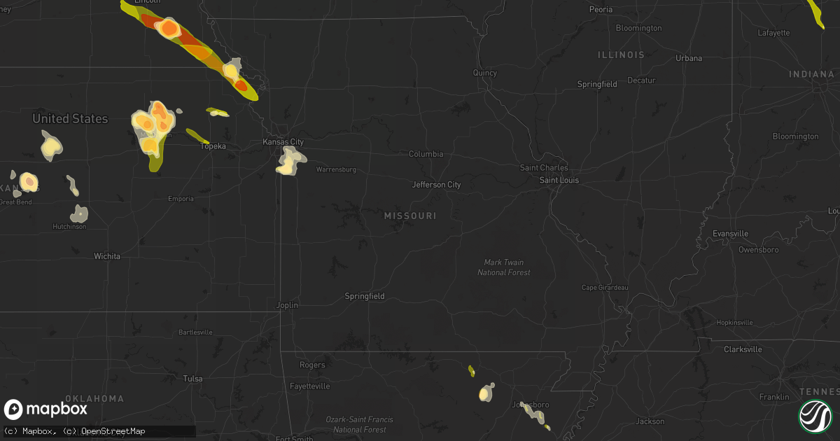
Hail Map in Missouri on June 27, 2013
Get this storm
June 27 map
$229
one time, instant access
Download today. No call, no setup
Keep the $229
Bought the map and want the full workflow? Apply the entire $229 to a subscription within 7 days. None of it is wasted.
Every map, not just this one
This buys you this map. Subscription and you get every map we run, in the markets you choose from a few cities to whole states to nationwide. Plus real-time alerts the moment a storm fires.
Contact data
Name, contact info, occupancy, even credit band for addresses in the footprint. You go from where it hit to who to call.
Become the source they trust
Unlimited branding weather history reports on demand. You already have the documented answer ready for the property owner, and you are the one who showed up with it.
Property data and RoofTrace estimates
Pull up any address you have got, its value and the exact code rules for that jurisdiction, straight from One Click Code. Then RoofTrace estimates the squares, pitch, and roof value, priced the way you price.
Storm reports in Missouri
Missouri
| Date | Description |
|---|---|
| 06/27/201312:30 PM CDT | Several large tree limbs down south side of lone jack |
| 06/27/201312:20 PM CDT | 3 to 4 inch diameter tree down. |
| 06/27/201312:00 PM CDT | Numerous trees down across hwy 150. |
| 06/27/201311:57 AM CDT | Numerous trees...large branches and some fencing down across legacy wood...windsboro and cantebury subdivisions. Delayed report. |
| 06/27/201311:45 AM CDT | 3 to 4 inch tree limb down. |
| 06/27/201311:35 AM CDT | Tree across lees summit road near truman medical center. |
| 06/27/201311:00 AM CDT | Large bradford tree snapped. Additional tree damage reported nearby. |
| 06/27/201310:45 AM CDT | 3 to 4 inch tree limb down. |
| 06/27/201310:35 AM CDT | Tree across lees summit road near truman medical center. |
| 06/27/20133:45 AM CDT | Late report. A few trees and numerous tree limbs were blown down countywide. M highway blocked by a tree. |
| 06/27/20133:30 AM CDT | A few scattered outages due trees and limbs down...or lighting along highway 60 in the winona and birch tree areas. |
| 06/27/20133:30 AM CDT | 6 inch diameter limb snapped off of a healthy tree. Report via espotter. |
| 06/27/20133:10 AM CDT | Sporadic power outages due to tree and limb damage and lightning. |
| 06/27/20133:05 AM CDT | Tree blown down near route jj and highway 95. |
| 06/27/20132:40 AM CDT | Trees limbs downed phone lines. |
| 06/27/20132:35 AM CDT | Trees down in mt zion area off state hwy b. Time estimated from radar. |
| 06/27/20132:30 AM CDT | Power outages due to trees and power lines down from the roby area south to near houston. |
| 06/27/20132:30 AM CDT | Tree blown down on hadner road south of logan. |
| 06/27/20132:25 AM CDT | Several 4-6 inch diameter trees snapped. |
| 06/27/20132:18 AM CDT | Fort leonard wood asos measured a 58 mph wind gust |
| 06/27/20132:15 AM CDT | Large tree blown onto house causing roof damage. |
| 06/27/20132:15 AM CDT | Fort leonard wood asos measured a 58 mph wind gust |
| 06/27/20132:15 AM CDT | A local report indicates 60 MPH wind near MARSHFIELD |
| 06/27/20132:15 AM CDT | A local report indicates 64 MPH wind near HIGHLANDVILLE |
| 06/27/20132:03 AM CDT | Estimated 60 to 70 mph wind gusts. |
| 06/27/20131:55 AM CDT | Several trees and power lines down across city. |
| 06/27/20131:55 AM CDT | Tree snapped in yard. Dime sized hail also reported. |
| 06/27/20131:54 AM CDT | A local report indicates 70 MPH wind near 1 NW REPUBLIC |
| 06/27/20131:53 AM CDT | Modot road sensor at i-44 and hwy 65 measured a 58 mph wind gust. |
| 06/27/20131:53 AM CDT | Wind gusts 50 to 60 mph reported. Near sunset and kansas expwy. |
| 06/27/20131:53 AM CDT | Wind gusts estimated 55-60 mph. |
| 06/27/20131:50 AM CDT | Quarter sized hail also reported. |
| 06/27/20131:50 AM CDT | A local report indicates 1.00 inch wind near REPUBLIC |
| 06/27/20131:48 AM CDT | Tree down on house at grant and web street. |
| 06/27/20131:48 AM CDT | Three very large limbs down near james river freeway and hwy ff. |
| 06/27/20131:45 AM CDT | Power reported out in south republic. |
| 06/27/20131:39 AM CDT | Off duty nws meteorologist estimating 50-60 mph wind gusts at lake of the ozarks. |
| 06/27/20131:32 AM CDT | Osage beach quick stop estimates 60-70 mph wind gusts. |
| 06/27/20131:15 AM CDT | A few large branches down. Report via social media. |
| 06/27/20131:08 AM CDT | A local report indicates 70 MPH wind near LAURIE |
| 06/27/20131:01 AM CDT | Trees blocking south bound lane 1 mile north of gravios mills on hwy. |
| 06/27/20131:01 AM CDT | Tree reported down across highway 52. |
| 06/27/201312:50 AM CDT | Four inch diameter tree limbs reported down. |
| 06/27/201312:44 AM CDT | Two 4 inch limbs snapped off of healthy tree |
| 06/27/201312:37 AM CDT | A local report indicates 62 MPH wind near WARSAW |
| 06/27/201312:30 AM CDT | A local report indicates 64 MPH wind near COLE CAMP |
| 06/27/201312:26 AM CDT | At 32nd and quisenberry rd |
| 06/27/201312:05 AM CDT | Thunderstorm wind gust measured at 64 mph. |
| 06/26/201311:50 PM CDT | Tree limbs down on county road vv |
| 06/26/201311:48 PM CDT | 2 to 3 inch diameter limbs down |
| 06/26/201311:15 PM CDT | Several large limbs down between swope park and the paseo |
| 06/26/201311:15 PM CDT | 5 minutes of half dollar sized hail...relayed by kctv5 |
| 06/26/201311:13 PM CDT | A local report indicates 1.00 inch wind near 3 E BELTON |
| 06/26/201311:13 PM CDT | A local report indicates 1.75 inch wind near RAYMORE |
| 06/26/201311:11 PM CDT | Relayed by police department |
| 06/26/201311:10 PM CDT | A local report indicates 1.00 inch wind near SW RAYMORE |
| 06/26/201311:10 PM CDT | Delayed report |
All States Impacted by Hail Map on June 27, 2013
Cities Impacted by Hail Map on June 27, 2013
- White Cloud, KS
- Rulo, NE
- Hiawatha, KS
- Robinson, KS
- Strawberry, AR
- Smithville, AR
- Cave City, AR
- Sulphur Rock, AR
- Lincoln, KS
- Sylvan Grove, KS
- Holton, KS
- New Haven, IN
- Churubusco, IN
- Huntertown, IN
- Columbia City, IN
- Arcola, IN
- Grabill, IN
- Fort Wayne, IN
- Roanoke, IN
- Tomahawk, WI
- Gleason, WI
- Manhattan, KS
- Leonardville, KS
- Riley, KS
- Randolph, KS
- Olsburg, KS
- Silver Lake, KS
- Topeka, KS
- Wamego, KS
- Saint George, KS
- Westmoreland, KS
- Frankfort, KS
- Onaga, KS
- Blue Rapids, KS
- Holyrood, KS
- Claflin, KS
- Griffith, IN
- Gary, IN
- Schererville, IN
- Merrillville, IN
- Crown Point, IN
- Deerbrook, WI
- Grandview, MO
- Lees Summit, MO
- Belton, MO
- Kansas City, MO
- Raymore, MO
- Cleveland, MO
- Peculiar, MO
- Fort Riley, KS
- Alta Vista, KS
- Green, KS
- Milford, KS
- Junction City, KS
- Ogden, KS
- Dwight, KS
- Albion, NE
- Hoisington, KS
- Bushton, KS
- Wilson, KS
- Dorrance, KS
- Manitowoc, WI
- Warsaw, IN
- Walkerton, IN
- Lakeville, IN
- Bremen, IN
- Etna Green, IN
- Plymouth, IN
- Bourbon, IN
- Atwood, IN
- North Liberty, IN
- Adams, NE
- Burr, NE
- Sterling, NE
- Cook, NE
- Douglas, NE
- Tecumseh, NE
- Highland, KS
- Craig, MO
- Forest City, MO
- Falls City, NE
- Troy, KS
- Inman, KS
- Lancaster, KS
- Two Rivers, WI
- Whitelaw, WI
- Reedsville, WI
- Rhinelander, WI
- Eagle River, WI
- Three Lakes, WI
- Milan, MI
- Ypsilanti, MI
- Willis, MI
- Bronwood, GA
- Dawson, GA
- Aniwa, WI
- Antigo, WI
- Kokomo, IN
- Hazelhurst, WI
- Harshaw, WI
- Lake Tomahawk, WI
- Brookville, KS
- Falun, KS
- Marquette, KS
- Mcpherson, KS
- Great Bend, KS
- Fond Du Lac, WI
- Firth, NE
- Highland, IN
- Crab Orchard, NE
- Tyronza, AR
- Marked Tree, AR
- Hammond, IN
- Beverly, KS
- Barnard, KS
- Beloit, KS
- Hunter, KS
- Bucyrus, KS
- Stilwell, KS
- Valley Falls, KS
- Nortonville, KS
- Minocqua, WI
- Woodruff, WI
- Pelican Lake, WI
- Russell, KS
- Hebron, IN
- Hobart, IN
- Ash Flat, AR
- Hardy, AR
- Nappanee, IN
- Leesburg, IN
- Perrysburg, OH
- Osborne, KS
- Tipton, KS
- Ellsworth, KS
- Downs, KS
- Glen Elder, KS
- Kewaunee, WI
- Champion, MI
- Republic, MI
- Plymouth, NE
- Fairbury, NE
- Jansen, NE
- Geneva, IN
- Berne, IN
- Greenwood, MO
- Lone Jack, MO
- Grain Valley, MO
- Leawood, KS
- Pleasant Hill, MO
- Independence, MO
- Harrisonville, MO
- Overland Park, KS
- Bay, AR
- Jonesboro, AR
- Weiner, AR
- Bono, AR
- Lake City, AR
- Harrisburg, AR
- Trumann, AR
- Black Rock, AR
- Cord, AR
- Saffell, AR
- Bunker Hill, KS
- Hutchinson, KS
- Buhler, KS
- Moundridge, KS
- Twelve Mile, IN
- Kewanna, IN
- Lucerne, IN
- Galveston, IN
- Onward, IN
- Logansport, IN
- Walton, IN
- Bunker Hill, IN
- Grissom Arb, IN
- Peru, IN
- Rushville, MO
- Atchison, KS
- Denton, KS
- Saint Joseph, MO
- Wathena, KS
- De Kalb, MO
- Bendena, KS
- Sprague, NE
- Auburn, NE
- Table Rock, NE
- Verdon, NE
- Milford, NE
- Martell, NE
- Denton, NE
- Elk Creek, NE
- Crete, NE
- Shubert, NE
- Dorchester, NE
- Stella, NE
- Humboldt, NE
- Bennet, NE
- Steinauer, NE
- Pleasant Dale, NE
- Johnson, NE
- Dawson, NE
- Cortland, NE
- Seward, NE
- Roca, NE
- Hallam, NE
- Lincoln, NE
- Panama, NE
- Hickman, NE
- Petersburg, NE
- East Chicago, IN
- Schaumburg, IL
- Barrington, IL
- Hoffman Estates, IL
- Chicago, IL
- Berwyn, IL
- River Forest, IL
- Maywood, IL
- Bellwood, IL
- Forest Park, IL
- Melrose Park, IL
- Cicero, IL
- Oak Park, IL
- Maumee, OH
- Toledo, OH
- Salem, NE
- Morrill, KS
- White City, KS
- Council Grove, KS
- Alma, KS
- Effingham, KS
- Saint Marys, KS
- Delia, KS
- Rossville, KS
- Casco, WI
- Luxemburg, WI
- Summit Lake, WI
- Poughkeepsie, AR
- Cherokee Village, AR
- Spalding, NE
- Greeley, NE


