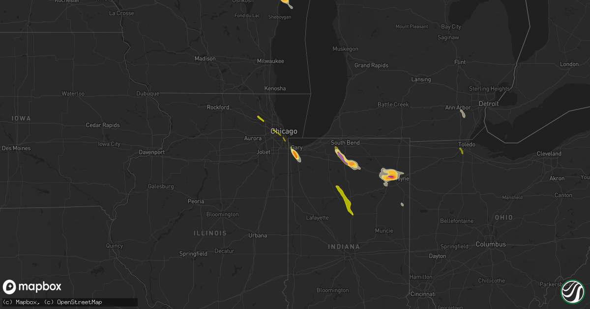
Hail Map on June 27, 2013
Get this storm
June 27 map
$229
one time, instant access
Download today. No call, no setup
Keep the $229
Bought the map and want the full workflow? Apply the entire $229 to a subscription within 7 days. None of it is wasted.
Every map, not just this one
This buys you this map. Subscription and you get every map we run, in the markets you choose from a few cities to whole states to nationwide. Plus real-time alerts the moment a storm fires.
Contact data
Name, contact info, occupancy, even credit band for addresses in the footprint. You go from where it hit to who to call.
Become the source they trust
Unlimited branding weather history reports on demand. You already have the documented answer ready for the property owner, and you are the one who showed up with it.
Property data and RoofTrace estimates
Pull up any address you have got, its value and the exact code rules for that jurisdiction, straight from One Click Code. Then RoofTrace estimates the squares, pitch, and roof value, priced the way you price.
States Impacted by Hail Map on June 27, 2013
Storm reports
Indiana
| Date | Description |
|---|---|
| 06/27/20136:58 PM CDT | Relayed by wsbt |
| 06/27/20136:54 PM CDT | A local report indicates 1.00 inch wind near MERRILLVILLE |
| 06/27/20136:50 PM CDT | Lasted for two minutes and was preceded by severe wind gusts. |
| 06/27/20136:46 PM CDT | A few trees and power lines downed. Time estimated per other report of high winds in meerillville. |
| 06/27/20136:46 PM CDT | Wind gusts lasted for around two minutes. |
| 06/27/20136:42 PM CDT | Relayed by wndu |
| 06/27/20136:38 PM CDT | Several reports of quarter to half dollar sized hail relayed by wsbt |
| 06/27/20136:36 PM CDT | Measured by the awos at the gary airport |
| 06/27/20135:55 PM CDT | Tree limbs and patio furniture blown over. Time estimated from radar. |
| 06/27/20135:05 PM CDT | Ponding of water along road side as well. Located on us highway 31 |
| 06/27/20135:05 PM CDT | Dime size hail also reported. |
| 06/27/20134:45 PM CDT | A local report indicates 1.00 inch wind near BUNKER HILL |
| 06/27/20134:41 PM CDT | A local report indicates 58 MPH wind near GRISSOM AFB |
| 06/27/20134:25 PM CDT | A local report indicates 60 MPH wind near ADAMSBORO |
| 06/27/20134:25 PM CDT | A local report indicates 1.00 inch wind near ADAMSBORO |
| 06/27/20134:05 PM CDT | Power lines down across sr 17 |
| 06/26/20138:55 PM CDT | A local report indicates 1.00 inch wind near GENEVA |
| 06/26/20138:55 PM CDT | Roof off of barn at s 000 rd and 800 s. Several trees down in the area. Corn flattened. Time estimated. |
| 06/26/20138:00 PM CDT | Law enforcement relayed report of a barn suffering severe damage. Roof blown off. |
| 06/26/20137:52 PM CDT | A local report indicates 1.75 inch wind near 2 ESE ARCOLA |
| 06/26/20137:51 PM CDT | Large tree limbs down on bass road near hamilton rd |
| 06/26/20137:51 PM CDT | Measured by ham on butler road |
| 06/26/20137:50 PM CDT | Measured at wfft studios |
| 06/26/20137:48 PM CDT | At wane studios |
| 06/26/20137:25 PM CDT | A local report indicates 1.00 inch wind near 2 E GOBLESVILLE |
| 06/26/20137:15 PM CDT | One tree downed |
| 06/26/20137:15 PM CDT | Two trees down in the road near the atwood fire station |
| 06/26/20137:06 PM CDT | One tree downed |
Alabama
| Date | Description |
|---|---|
| 06/27/20136:49 PM CDT | Powerlines down in the roadway near the intersection of lower tuskegee road and pemberton road. Time estimated from radar. |
| 06/27/20136:22 PM CDT | Two trees and powerlines down along highway 229 just west of martin dam. |
| 06/27/20136:13 PM CDT | Trees and powerlines down at highway 63 and west cotton road. |
| 06/27/20136:07 PM CDT | Several locations with trees down across the southern part of randolph county. |
| 06/27/20136:03 PM CDT | Trees down across highway 9 between equality and central. |
| 06/27/20138:30 AM CDT | Several trees were reported down in the fyffe community along highway 75 near rainsville. |
| 06/27/20138:25 AM CDT | A roof was blown off of a sawmill along county road 47 and county road 92 southwest of powell. |
| 06/27/20137:31 AM CDT | Numerous trees blown down in the antioch community. An outdoor structure/potato barn sustained heavy damage. A couple of fields of corn were blown down. |
| 06/26/201311:40 PM CDT | One tree down along cr 113. One tree also down along cr 58...which is approximately 3-4 miles to the east. Time estimated from radar. |
| 06/26/201311:00 PM CDT | One tree down near intersection of cr 68 and cr 99. Time estimated from radar. |
| 06/26/20138:18 PM CDT | Trees down along shady grove road on the east side of hurtsboro. |
| 06/26/20137:30 PM CDT | Trees down along shady grove road on the east side of hurtsboro. |
Kansas
| Date | Description |
|---|---|
| 06/27/20136:56 PM CDT | A local report indicates 58 MPH wind near MEDICINE LODGE |
| 06/27/20136:55 PM CDT | A local report indicates 62 MPH wind near 4 NNW CLEARWATER |
| 06/27/20136:54 PM CDT | 5 inch diameter trees limbs down. |
| 06/27/20136:54 PM CDT | Trained spotter estimates winds of 75 to 80 mph. |
| 06/27/20136:54 PM CDT | A local report indicates 58 MPH wind near JABARA AIRPORT |
| 06/27/20136:54 PM CDT | Trained spotter reports an 8 to 12 inch diameter tree was uprooted with an estimated 75 to 80 mph gust. |
| 06/27/20136:53 PM CDT | A local report indicates 59 MPH wind near MCCONNELL AIR FORCE BAS |
| 06/27/20136:50 PM CDT | 70mph wind gusts reported near maize and 21st. |
| 06/27/20136:50 PM CDT | Tree limbs were blown down. |
| 06/27/20136:49 PM CDT | Several large trees and tree limbs down across town and shingles blown off roofs. |
| 06/27/20136:47 PM CDT | A local report indicates 80 MPH wind near 2 E HARPER |
| 06/27/20136:44 PM CDT | Measured 2.25 inch hail |
| 06/27/20136:41 PM CDT | A local report indicates 58 MPH wind near MEDICINE LODGE |
| 06/27/20136:40 PM CDT | Spotter estimates 65 to 70 mph winds and 2 to 3 inch tree limbs down. |
| 06/27/20136:38 PM CDT | A local report indicates 60 MPH wind near 5 NW BENTLEY |
| 06/27/20136:37 PM CDT | Measured 71mph wind gust at 21st and tyler. |
| 06/27/20136:37 PM CDT | A local report indicates 63 MPH wind near NEWTON AIRPORT |
| 06/27/20136:30 PM CDT | 2 inch trees down with winds estimated at 60 mph near willowdale. Time estimated from radar. |
| 06/27/20136:21 PM CDT | Kake tv reported 60mph winds in hesston. |
| 06/27/20136:20 PM CDT | A local report indicates 60 MPH wind near HESSTON |
| 06/27/20136:19 PM CDT | A local report indicates 60 MPH wind near HALSTEAD |
| 06/27/20136:17 PM CDT | A local report indicates 59 MPH wind near HUTCHINSON AIRPORT |
| 06/27/20136:04 PM CDT | A local report indicates 60 MPH wind near 4 SE CULLISON |
| 06/27/20136:00 PM CDT | Measured wind gust of 92mph prior to anemometer snapping. Numerous large trees and power lines down all across town. |
| 06/27/20135:55 PM CDT | Delayed report. Time based on radar. |
| 06/27/20135:55 PM CDT | 55 to 60 mph winds from pratt to coats |
| 06/27/20135:51 PM CDT | A local report indicates 80 MPH wind near 1 W MCPHERSON |
| 06/27/20135:51 PM CDT | Several trees down in the town of mcpherson. |
| 06/27/20135:45 PM CDT | Spotter was on north side of town. |
| 06/27/20135:45 PM CDT | Hay shed was blown down. Time adjusted by radar. |
| 06/27/20135:41 PM CDT | 70 to 80 mph winds on the north side of mcpherson |
| 06/27/20135:40 PM CDT | A local report indicates 70 MPH wind near 4 NW MCPHERSON |
| 06/27/20135:33 PM CDT | Very limited visibility due to rain and winds. |
| 06/27/20135:31 PM CDT | 2 to 3 inch diameter tree limbs were blown down. |
| 06/27/20135:30 PM CDT | A local report indicates 60 MPH wind near GREENSBURG |
| 06/27/20135:30 PM CDT | Also estimated 60-70 mph winds knocked down trees all over town. Delayed report. |
| 06/27/20135:29 PM CDT | Empty semi trailer was blown over at mile marker 102 on highway 54. |
| 06/27/20135:17 PM CDT | 3 power poles were snapped due to high winds from the thunderstorms on highway 54. |
| 06/27/20135:15 PM CDT | A semi was blown over by high winds. |
| 06/27/20135:15 PM CDT | Power poles and 12 to 15 inch tree downed in the town of falun. Delayed report with time based on radar. |
| 06/27/20135:13 PM CDT | A power pole was blown down in bucklin. |
| 06/27/20135:11 PM CDT | 3 to 4 inch limbs down. |
| 06/27/20135:06 PM CDT | A local report indicates 60 MPH wind near 3 S FORD |
| 06/27/20135:02 PM CDT | A local report indicates 73 MPH wind near 5 S BEVERLY |
| 06/27/20135:00 PM CDT | Power poles downed. Delayed report with time based on radar. |
| 06/27/20135:00 PM CDT | Tree damage on the east side of town. |
| 06/27/20134:55 PM CDT | 12 inch diameter tree blown over. |
| 06/27/20134:53 PM CDT | A local report indicates 74 MPH wind near ELLSWORTH |
| 06/27/20134:50 PM CDT | 3 inch tree branches broken. |
| 06/27/20134:49 PM CDT | A local report indicates 60 MPH wind near 6 WSW GLENDALE |
| 06/27/20134:47 PM CDT | A local report indicates 64 MPH wind near ELLSWORTH |
| 06/27/20134:46 PM CDT | 4 inch tree branches broken in westfall |
| 06/27/20134:41 PM CDT | A local report indicates 1.00 inch wind near W BUSHTON |
| 06/27/20134:40 PM CDT | A local report indicates 61 MPH wind near ELLSWORTH |
| 06/27/20134:39 PM CDT | Measured by ksn weatherlab network station at the otis-bison high school. |
| 06/27/20134:37 PM CDT | 70 to 80 mph winds with heavy rain in the city of lincoln. |
| 06/27/20134:37 PM CDT | A local report indicates 4.25 inch wind near 5 N CLAFLIN |
| 06/27/20134:35 PM CDT | Surface observation from dodge city measured 60 mph wind. |
| 06/27/20134:31 PM CDT | A local report indicates 60 MPH wind near 2 NW DODGE CITY |
| 06/27/20134:30 PM CDT | Powerlines down. Time estimated from radar |
| 06/27/20134:25 PM CDT | Wind driven hail with gusts to 80mph. |
| 06/27/20134:25 PM CDT | One and three quarter inch hail was blown by the winds. |
| 06/27/20134:24 PM CDT | A local report indicates 80 MPH wind near 4 W LINCOLN |
| 06/27/20134:19 PM CDT | Branches and debris blown through the air over highway 18. |
| 06/27/20134:15 PM CDT | A local report indicates 70 MPH wind near SYLVAN GROVE |
| 06/27/20134:15 PM CDT | Large tree limbs were down and a window was blown out at a residence in ingalls. Report received via social media. |
| 06/27/20134:10 PM CDT | Pea size hail was also reported |
| 06/27/20134:05 PM CDT | Very strong winds were also noted but no speed reported. |
| 06/27/20134:04 PM CDT | A local report indicates 1.00 inch wind near 3 N ASH GROVE |
| 06/27/20134:04 PM CDT | A local report indicates 1.00 inch wind near 4 N ASH GROVE |
| 06/27/20134:01 PM CDT | A local report indicates 1.00 inch wind near HUNTER |
| 06/27/20133:57 PM CDT | Estimated wind gusts of 70 to 80 mph |
| 06/27/20133:55 PM CDT | A local report indicates 1.00 inch wind near HUNTER |
| 06/27/20133:54 PM CDT | A local report indicates 65 MPH wind near 4 NW ASH GROVE |
| 06/27/20133:39 PM CDT | A local report indicates 1.00 inch wind near TIPTON |
| 06/27/20133:32 PM CDT | A local report indicates 1.00 inch wind near 1 N TIPTON |
| 06/27/20133:24 PM CDT | A local report indicates 1.00 inch wind near 8 E OSBORNE |
| 06/27/20139:24 AM CDT | A local report indicates 2.00 inch wind near 2 NW WHITE CLOUD |
| 06/27/20139:24 AM CDT | A local report indicates 75 MPH wind near 2 NW WHITE CLOUD |
| 06/27/201312:25 AM CDT | Also power flashes in south part of town. |
| 06/27/201312:20 AM CDT | Power lines reported down. |
| 06/27/201312:15 AM CDT | A local report indicates 70 MPH wind near 1 N ARMA |
| 06/26/201311:48 PM CDT | Power lines reported down near devon. |
| 06/26/201311:00 PM CDT | Estimated 60-70 mph winds. Trees down and power lines down. Town without power. Windows broken. Delayed report. |
| 06/26/201311:00 PM CDT | Estimated 60-70 mph winds. Trees and power lines down. Town without power. Delayed report. |
| 06/26/201311:00 PM CDT | Winds estimated at 60-70 mph winds. Trees and power lines down. Town without power. Delayed report. |
| 06/26/201310:02 PM CDT | A local report indicates 70 MPH wind near 3 N NEOSHO RAPIDS |
| 06/26/201310:00 PM CDT | Tree and tree limbs down. Tree approximately two feet in diameter. Tree limbs up to ten inches in diameter. Time estimated. From social media. |
| 06/26/201310:00 PM CDT | A local report indicates 60 MPH wind near 2 E EMPORIA |
| 06/26/20139:59 PM CDT | Small branches down |
| 06/26/20139:51 PM CDT | A local report indicates 1.00 inch wind near N LAWRENCE |
| 06/26/20139:50 PM CDT | Mostly dime size with a few quarter size hailstones. |
| 06/26/20139:33 PM CDT | Picture and report from social media. Time radar estimated. |
| 06/26/20139:15 PM CDT | A local report indicates 1.00 inch wind near 2 E PARKERVILLE |
| 06/26/20139:00 PM CDT | Wind gusts estimated 60 to 70 mph |
| 06/26/20138:50 PM CDT | Off duty nws employee reported widespread major tree damage across west wichita...including some trees on homes. |
| 06/26/20138:49 PM CDT | Dime size hail was also reported. |
| 06/26/20138:47 PM CDT | A local report indicates 60 MPH wind near 3 ESE SILVER LAKE |
| 06/26/20138:43 PM CDT | A local report indicates 69 MPH wind near JUNCTION CITY |
| 06/26/20138:39 PM CDT | A local report indicates 1.00 inch wind near 2 NE SILVER LAKE |
| 06/26/20138:38 PM CDT | Quarter hail and up to the size of golfballs. Estimated winds of 55 mph. |
| 06/26/20138:36 PM CDT | Delayed report. Three-quarter inch to one-inch diameter hail reported. |
| 06/26/20138:27 PM CDT | A local report indicates 1.00 inch wind near 6 NW MANHATTAN |
| 06/26/20138:13 PM CDT | Picture and report from social media. Time radar estimated. |
| 06/26/20138:06 PM CDT | Report via social media photo. |
| 06/26/20138:06 PM CDT | Mostly dime size with a few quarter size hailstones. |
| 06/26/20138:06 PM CDT | A local report indicates 1.75 inch wind near 5 N KEATS |
| 06/26/20138:02 PM CDT | Hail to the size of golfballs nw of flush. Picture and report provided on social media. Time radar estimated. |
| 06/26/20137:54 PM CDT | Two foot diameter knocked over in town. |
| 06/26/20137:52 PM CDT | Numerous large trees down around town and a traffic light was also blown down on north side of town. |
| 06/26/20137:49 PM CDT | A local report indicates 1.00 inch wind near ESE RANDOLPH |
| 06/26/20137:45 PM CDT | A local report indicates 1.50 inch wind near 3 E LEONARDVILLE |
| 06/26/20137:43 PM CDT | A local report indicates 1.75 inch wind near 8 SSW WESTMORELAND |
| 06/26/20137:41 PM CDT | A local report indicates 58 MPH wind near ARKANSAS CITY |
| 06/26/20137:40 PM CDT | Tree damage being reported in town. |
| 06/26/20137:36 PM CDT | I-35 at state line. Reported by kwtv. |
| 06/26/20137:32 PM CDT | A local report indicates 63 MPH wind near STROTHER FIELD AIRPORT |
| 06/26/20137:32 PM CDT | A local report indicates 70 MPH wind near WINFIELD |
| 06/26/20137:25 PM CDT | Several large tree limbs were also knocked down by the winds. |
| 06/26/20137:22 PM CDT | Mostly quarter size with a few bigger stones up to 1.25 inches |
| 06/26/20137:22 PM CDT | Numerous large tree down in town. |
| 06/26/20137:20 PM CDT | 6 inch diameter tree limbs down in the city. |
| 06/26/20137:17 PM CDT | Power poles knocked down from thunderstorm wind gusts. |
| 06/26/20137:16 PM CDT | Numerous tree limbs knocked down by thunderstorm wind gusts in udall. |
| 06/26/20137:15 PM CDT | A local report indicates 1.00 inch wind near ARRINGTON |
| 06/26/20137:14 PM CDT | A local report indicates 70 MPH wind near 1 NW UDALL |
| 06/26/20137:11 PM CDT | Several 4 to 5 inch tree limbs knocked down. |
| 06/26/20137:10 PM CDT | Estimated quarter size but some may have been larger. |
| 06/26/20137:10 PM CDT | Off duty nws employee reported widespread major tree damage across west wichita...including some trees on homes. |
| 06/26/20137:10 PM CDT | 8 inch diameter tree down. Reported by nws employee. Delayed report |
| 06/26/20137:07 PM CDT | Hail up to the size of golfballs. Report from social media. Time radar estimated. |
| 06/26/20137:07 PM CDT | A local report indicates 1.25 inch wind near 6 E HOLTON |
| 06/26/20137:05 PM CDT | A local report indicates 1.00 inch wind near NNW WESTMORELAND |
| 06/26/20137:02 PM CDT | A local report indicates 69 MPH wind near MCCONNELL AIR FORCE BAS |
| 06/26/20137:02 PM CDT | Trained spotter reports scattered elm trees down of 2 to 3 feet in diameter from 120th to 127th east on douglas. |
| 06/26/20137:02 PM CDT | Fireworks tent blown over at 167th and us54 in west wichita. |
| 06/26/20137:00 PM CDT | Several baggage cars flipped over. Smaller federal express cargo plane sustained wing damage and was turned 180 degrees. 3 overhead garage doors were blown in. |
| 06/26/20137:00 PM CDT | A local report indicates 89 MPH wind near WICHITA MID CONTINENT A |
Nebraska
| Date | Description |
|---|---|
| 06/27/201312:55 PM CDT | A local report indicates 1.00 inch wind near 4 E DAYKIN |
| 06/27/20139:00 AM CDT | Tree and power line blown down. |
| 06/27/20138:35 AM CDT | A local report indicates 60 MPH wind near JOHNSON |
| 06/27/20138:05 AM CDT | A local report indicates 4.25 inch wind near 2 E STERLING |
| 06/27/20138:02 AM CDT | A local report indicates 70 MPH wind near STERLING |
| 06/27/20137:55 AM CDT | Several large trees down. |
| 06/27/20137:45 AM CDT | Power lines down. |
Wisconsin
| Date | Description |
|---|---|
| 06/27/20136:08 PM CDT | Golf ball to tennis ball hail in city. Numerous car wind shields damaged in the city. |
| 06/27/20136:03 PM CDT | Power pole down near county s and jj. |
| 06/27/20136:03 PM CDT | A local report indicates 1.75 inch wind near MANITOWOC |
| 06/27/20135:55 PM CDT | 2 inch diameter tree limbs down near county d and w also some flooding in area fields. |
| 06/27/20135:37 PM CDT | A local report indicates 60 MPH wind near ELKHART LAKE |
| 06/27/20135:37 PM CDT | Powerlines down and two trees of unknown size down. Time estimated from radar. |
| 06/27/20135:18 PM CDT | Numerous trees down in clintonville near walnut and grove streets. Also nickle hail covering the ground. |
| 06/27/20135:12 PM CDT | 34 mph wind gust |
| 06/27/20135:08 PM CDT | Also mixed with pea hail. |
| 06/27/20135:00 PM CDT | Few large branches down in gresham. |
| 06/27/20134:27 PM CDT | Few trees and powerlines down in birnamwood |
| 06/27/20133:28 PM CDT | Larger than quarter size hail at wjfw-tv in rhinelander |
| 06/27/20133:20 PM CDT | Courtesy of wjfw-tv |
| 06/27/20133:15 PM CDT | A local report indicates 1.00 inch wind near 1 W RHINELANDER |
| 06/27/20133:10 PM CDT | Hail size ranged from golf ball to dime size in newbold. Relayed from wjfw rhinelander from social media. |
| 06/27/20132:52 PM CDT | Several trees near 100th and capitol drive uprooted or with branches down. Time estimated. Relayed via social media. |
| 06/27/20132:50 PM CDT | Significant tree damage in butler. Some trees uprooted. Relayed by broadcast media over social media. Time estimated. |
| 06/27/20132:48 PM CDT | Extensive tree damage. Relayed via social media. Time estimated. |
| 06/27/20132:18 PM CDT | Also reported strong winds. Report relayed via social media. Time estimated. |
Illinois
| Date | Description |
|---|---|
| 06/27/20136:15 PM CDT | Slightly larger than quarter sized hail at the churchs chicken. |
| 06/27/20136:07 PM CDT | Large tree down on car. Winds estimated 60 mph. |
| 06/27/20135:59 PM CDT | Numerous moderate sized branches downed. |
| 06/27/20135:50 PM CDT | Estimated 70 mph gust. 4-6 inch diameter tree branches down. Pea size hail also reported. |
Pennsylvania
| Date | Description |
|---|---|
| 06/27/20135:09 PM CDT | Trees reported down. |
| 06/27/20135:05 PM CDT | Trees down along i-80. |
| 06/27/20135:01 PM CDT | Trees reported down. |
| 06/27/20134:05 PM CDT | Trees down along route 26. |
| 06/27/20133:40 PM CDT | Trees down on pine grove mtn. |
| 06/27/20133:30 PM CDT | Trees down over roads |
| 06/27/20133:15 PM CDT | Trees reported down just off of route 45. |
| 06/27/20133:13 PM CDT | Trees reported down near creamery and creek roads in west cocalico twp. |
| 06/27/20133:05 PM CDT | A local report indicates a tornado near 2 SE LINDEN HALL |
| 06/27/20131:40 PM CDT | Trees and wires down |
| 06/27/20131:20 PM CDT | A local report indicates a tornado near 5 SW BLAIN |
| 06/27/20131:20 AM CDT | Wries reported down south of town |
Oklahoma
| Date | Description |
|---|---|
| 06/27/20136:25 PM CDT | A local report indicates 58 MPH wind near 16 NNE FREEDOM |
| 06/27/20136:25 PM CDT | A local report indicates 64 MPH wind near 1 SW BUFFALO |
| 06/26/20139:16 PM CDT | Power pole and transformer down at reno and rockwell. |
| 06/26/20139:10 PM CDT | A local report indicates 59 MPH wind near 4 WSW YUKON |
| 06/26/20139:10 PM CDT | A local report indicates 60 MPH wind near 3 NW WARR ACRES |
| 06/26/20139:09 PM CDT | A local report indicates 58 MPH wind near WILEY POST AIRPORT |
| 06/26/20139:08 PM CDT | A local report indicates 60 MPH wind near 4 WSW EDMOND |
| 06/26/20139:05 PM CDT | Nw 104 and council road. Tree damage. Red oak down. |
| 06/26/20138:56 PM CDT | Simmons rd and midwest |
| 06/26/20138:54 PM CDT | A local report indicates 59 MPH wind near CUSHING |
| 06/26/20138:43 PM CDT | Power lines down near highway 33 and may avenue. |
| 06/26/20138:40 PM CDT | A local report indicates 67 MPH wind near 3 ENE PAWNEE |
| 06/26/20138:40 PM CDT | Blowing dust also reduced visibility to 1/8 of a mile. |
| 06/26/20138:30 PM CDT | A local report indicates 60 MPH wind near 7 SSE RED ROCK |
| 06/26/20138:30 PM CDT | A local report indicates 58 MPH wind near VANCE AIR FORCE BASE |
| 06/26/20138:25 PM CDT | A local report indicates 66 MPH wind near 7 SSE RED ROCK |
| 06/26/20138:22 PM CDT | A local report indicates 60 MPH wind near KINGFISHER |
| 06/26/20138:22 PM CDT | A local report indicates 60 MPH wind near DOVER |
| 06/26/20138:20 PM CDT | Estimated 60 or higher. |
| 06/26/20138:15 PM CDT | A local report indicates 60 MPH wind near 8 W RALSTON |
| 06/26/20138:10 PM CDT | A local report indicates 59 MPH wind near 3 SE BRECKENRIDGE |
| 06/26/20138:07 PM CDT | A local report indicates 58 MPH wind near 4 SE ENID |
| 06/26/20138:05 PM CDT | A local report indicates 72 MPH wind near 8 E NEWKIRK |
| 06/26/20138:00 PM CDT | A local report indicates 58 MPH wind near 4 SSE BLACKWELL |
| 06/26/20137:59 PM CDT | A local report indicates 67 MPH wind near VANCE AIR FORCE BASE |
| 06/26/20137:56 PM CDT | On i-35. |
| 06/26/20137:55 PM CDT | A local report indicates 63 MPH wind near BLACKWELL |
| 06/26/20137:52 PM CDT | A local report indicates 61 MPH wind near VANCE AIR FORCE BASE |
| 06/26/20137:46 PM CDT | A local report indicates 1.00 inch wind near BLACKWELL |
| 06/26/20137:46 PM CDT | Trees down. Siding blown off of house. Most of town without power. |
| 06/26/20137:38 PM CDT | Major dust in air. |
| 06/26/20137:35 PM CDT | A local report indicates 58 MPH wind near 1 SW MEDFORD |
| 06/26/20137:20 PM CDT | A local report indicates 64 MPH wind near 8 W SLAPOUT |
| 06/26/20137:10 PM CDT | A local report indicates 58 MPH wind near 1 SSW CHEROKEE |
Colorado
| Date | Description |
|---|---|
| 06/27/20135:00 PM CDT | Wind gust at kendall mountain |
South Carolina
| Date | Description |
|---|---|
| 06/27/20136:18 PM CDT | Quarter size hail and large tree limbs down. |
| 06/27/20136:15 PM CDT | Quarter size hail and large tree limbs down. |
| 06/27/20136:15 PM CDT | 2 trees down and power outage in the hunters bend subdivision. |
| 06/27/20136:15 PM CDT | Tree down on a power line. |
| 06/27/20136:15 PM CDT | Top of a pine tree broken off. |
| 06/27/20135:53 PM CDT | Tree in roadway on hwy 177 at state line |
| 06/27/20134:28 PM CDT | Lynches river electric reported trees down on a powerline along miller road. |
| 06/27/20132:40 PM CDT | Trees down on gordon road near hwy 324. |
| 06/27/20132:11 PM CDT | Tree down on a powerline in the 9300 block of old georgetown road. |
| 06/27/20131:08 PM CDT | Sub severe winds estimated at 40 to 50 mph knocked down a diseased tree onto the awning of a pharmacy store. Initial report recieved via twitter. |
| 06/27/20131:07 PM CDT | *** 1 inj *** sub severe winds of 40 to 50 mph broke off a large branch of a diseased tree at a golf course. The branch landed on a golfer who was injured and taken to |
| 06/27/20131:04 PM CDT | A downburst developed just south of route 78 and traveled northeast about 1 mile before dissipating in the tall pines subdivision. Mainly sub severe winds of 40 to 50 m |
| 06/26/20139:01 PM CDT | County dispatch reported power lines down between erhardt and the colleton county line along highway 601. |
| 06/26/20138:28 PM CDT | County dispatch reported trees down on poplar road near highway 278. |
| 06/26/20138:25 PM CDT | County dispatch reported trees down along highway 3 near red oak road. |
| 06/26/20138:23 PM CDT | County dispatch reported trees down on kingfisher road. |
| 06/26/20137:12 PM CDT | Tree down on black dr |
Mississippi
| Date | Description |
|---|---|
| 06/26/20139:18 PM CDT | Tree uprooted on university of mississippi campus. Tree knocked on to a house on douglas street. |
| 06/26/20139:10 PM CDT | Tree downed on a gas meter at robert d. Grey street and a tree downed on a car at 1612 forest street in shelby. |
| 06/26/20138:07 PM CDT | Media reports of a mobile home being flipped |
| 06/26/20137:00 PM CDT | Quarter sized hail reported near craft road in olive branch |
Ohio
| Date | Description |
|---|---|
| 06/27/20135:35 PM CDT | Nickel to quarter size hail |
| 06/27/20135:24 PM CDT | Large branches and quarter size hail observed along route 20 in perrysburg. |
| 06/27/20135:17 PM CDT | 14 inch diameter tree uprooted. |
| 06/26/20138:10 PM CDT | Trees down on township road 182 in chesterville. |
| 06/26/20138:00 PM CDT | Trees and powerlines down on state route 95 in mt. Gilead |
Kentucky
| Date | Description |
|---|---|
| 06/27/20136:08 PM CDT | Viewer reported trees down in center |
Georgia
| Date | Description |
|---|---|
| 06/27/20134:34 PM CDT | Trees and power lines down on adams road near highway 80. |
| 06/27/20133:50 PM CDT | 911 center reports 3 trees blown down in the parrish street/brook circle/spalding street area on the east side of griffin. |
| 06/27/20133:42 PM CDT | Tree down on burkhalter road. |
| 06/27/20133:33 PM CDT | Tree down on old register way. |
| 06/27/20133:20 PM CDT | Off duty nws forecaster reported around a half dozen trees down in the vicinity of crosstown drive and brooksong way. |
| 06/27/20133:18 PM CDT | Tree down across excelsior church road near interstate 16. |
| 06/27/20133:15 PM CDT | Off duty nws forecaster reported one tree snapped at the kroger on crosstown blvd. |
| 06/27/20133:10 PM CDT | Emergency manager reported a tree blown down blocking peachtree parkway north of highway 54. |
| 06/26/201310:48 PM CDT | Public reported several large peacan trees down along lundy dairy road between hwy 74 and hwy 83. |
| 06/26/201310:31 PM CDT | Trees down at the 2600 block of liberty road south of albany. |
| 06/26/201310:30 PM CDT | Media relayed a viewer report of lots of debris on radium springs road in putney |
| 06/26/20139:57 PM CDT | Trees down on sasser road |
| 06/26/20139:50 PM CDT | Media relayed a viewer report of a tree down on highway 32 close to the lee county line with a lot of debris and limbs in the road. |
| 06/26/20139:45 PM CDT | Tree on a power line near the intersection of crawford street and 11th ave with power outages reported |
| 06/26/20139:42 PM CDT | Trees down on highway 118 between dawson and bronwood. Media reports trees are blocking the roadway. |
| 06/26/20139:42 PM CDT | Trees and power lines down in bronwood. Media also reports trees down on houses. |
North Carolina
| Date | Description |
|---|---|
| 06/27/20136:00 PM CDT | One tree down on entwistle and sr1439. Minor road flooding with high water signs deployed |
| 06/27/20135:45 PM CDT | One tree down on sr1748 power plant rd |
| 06/27/20135:22 PM CDT | House damaged by fallen tree. |
| 06/27/20135:20 PM CDT | Two trees down on edinburgh rd |
| 06/27/20135:15 PM CDT | Tree down blocking the road. Giddensville rd near i-40. |
| 06/27/20135:00 PM CDT | Tree blown down along gilbert road. Time estimated. |
| 06/27/20134:58 PM CDT | One tree down on us hwy 701 near campbell road. Time estimated by radar. |
| 06/27/20134:57 PM CDT | Three trees down on mitchell ford road. Time estimated by radar. |
| 06/27/20134:45 PM CDT | Trees down. |
| 06/27/20134:42 PM CDT | One tree down on nc 131. Time estimated by radar. |
| 06/27/20133:55 PM CDT | Trees and power lines down. |
| 06/27/20133:25 PM CDT | Several trees down. |
| 06/26/20139:26 PM CDT | Power lines down on pecan lane. |
Tennessee
| Date | Description |
|---|---|
| 06/27/20136:25 PM CDT | Large tree fell on a house on east dempsey street. |
| 06/27/20136:30 AM CDT | A couple large trees fell and blocked macon road 1 mile east of highway 196. |
| 06/27/20136:25 AM CDT | The public reported that a tree fell on a truck in the raleigh/berclair area. |
Texas
| Date | Description |
|---|---|
| 06/27/201312:19 AM CDT | A local report indicates 70 MPH wind near 2 NE LAKE TANGLEWOOD |
| 06/27/201312:15 AM CDT | Outbuilding destroyed. Some debris found one half mile away. Time estimated by landowner. |
| 06/27/201312:08 AM CDT | A local report indicates 64 MPH wind near 5 SSW AMARILLO |
| 06/26/201311:35 PM CDT | A local report indicates 59 MPH wind near 5 NNW AMARILLO |
| 06/26/201310:00 PM CDT | A local report indicates 60 MPH wind near 1 S BORGER |
| 06/26/20139:52 PM CDT | Roof blown off a large metal building that houses two businesses. Debris impacted and damaged three vehicles. Windows were shattered. Minor roof damage observed on serv |
| 06/26/20139:47 PM CDT | Three airport hanger doors were blown in. One hanger suffered minor roof damage. An abandoned building was heavily damaged. |
| 06/26/20139:45 PM CDT | Reports of bent signs... Leaning power poles... And downed limbs |
| 06/26/20139:45 PM CDT | Window blown out on a home. No estimate on wind speeds at the time. |
| 06/26/20139:45 PM CDT | A large roof completely blown off a building...a metal flag pole bent to a 45 degree angle...3 utility poles broken all in a 10 square block area in nw borger |
| 06/26/20137:30 PM CDT | A local report indicates 60 MPH wind near DARROUZETT |
New Mexico
| Date | Description |
|---|---|
| 06/27/201312:07 AM CDT | Ktcc asos. |
Arkansas
| Date | Description |
|---|---|
| 06/27/20136:30 PM CDT | A tree was downed along highway 69. |
| 06/27/20136:25 PM CDT | A tree was blown down. |
| 06/27/20136:20 PM CDT | Large tree limbs and power lines were downed at newport and diaz. |
| 06/27/20136:20 PM CDT | A few tree limbs were knocked down. In 10 minutes 0.5 inch of rain fell. |
| 06/27/20136:04 PM CDT | A tree was down on peace valley rd. Just west of ash flat. |
| 06/27/20136:00 PM CDT | Large tree limbs and power lines were downed at tuckerman. |
| 06/27/20135:30 PM CDT | Power poles blown over and roof blown off building in waldenburg |
| 06/27/20135:18 PM CDT | Fire department reported quarter sized hail in tyronza. |
| 06/27/20135:15 PM CDT | Public report of quarter size hail near trumann |
| 06/27/20134:45 PM CDT | Numerous reports of quarter size hail in the valley view and lawson road areas. |
| 06/27/20135:13 AM CDT | Blytheville airport measured 56 mph sustained with a gust to 78 mph. |
| 06/27/20135:09 AM CDT | Blytheville asos reported a 63 mph wind gust. |
Michigan
| Date | Description |
|---|---|
| 06/27/20136:15 PM CDT | Hail fell for several minutes. Mixture of quarter-pea and penny sized hail. Very heavy rain and gusty winds. |
| 06/27/20136:00 PM CDT | Numerous trees down and minor structural damage in 3 to 4 block radius in chikaming township |
| 06/27/20134:26 PM CDT | Multiple wires down |
| 06/27/20134:26 PM CDT | 8 inch diameter tree branch down |
| 06/27/20134:09 PM CDT | Wires down at dixie hwy and scott lake rd relayed by media |
| 06/27/20133:58 PM CDT | 10 inch tree limb snapped in half |
| 06/27/20133:55 PM CDT | 1.5 foot diameter tree down across waldon road between m15 and sashabaw |
| 06/27/20133:25 PM CDT | A local report indicates 1.25 inch wind near 5 SSE ANN ARBOR |
| 06/27/20133:23 PM CDT | Intersection of mccrone and willow |
| 06/27/20131:55 PM CDT | 3-4 inch diameter tree limbs down |
| 06/27/20131:46 PM CDT | Tree limbs downed and trees uprooted. Mailboxes also reported blown down |
| 06/27/20131:38 PM CDT | Large tree limbs downed |
Missouri
| Date | Description |
|---|---|
| 06/27/201312:30 PM CDT | Several large tree limbs down south side of lone jack |
| 06/27/201312:20 PM CDT | 3 to 4 inch diameter tree down. |
| 06/27/201312:00 PM CDT | Numerous trees down across hwy 150. |
| 06/27/201311:57 AM CDT | Numerous trees...large branches and some fencing down across legacy wood...windsboro and cantebury subdivisions. Delayed report. |
| 06/27/201311:45 AM CDT | 3 to 4 inch tree limb down. |
| 06/27/201311:35 AM CDT | Tree across lees summit road near truman medical center. |
| 06/27/201311:00 AM CDT | Large bradford tree snapped. Additional tree damage reported nearby. |
| 06/27/201310:45 AM CDT | 3 to 4 inch tree limb down. |
| 06/27/201310:35 AM CDT | Tree across lees summit road near truman medical center. |
| 06/27/20133:45 AM CDT | Late report. A few trees and numerous tree limbs were blown down countywide. M highway blocked by a tree. |
| 06/27/20133:30 AM CDT | 6 inch diameter limb snapped off of a healthy tree. Report via espotter. |
| 06/27/20133:30 AM CDT | A few scattered outages due trees and limbs down...or lighting along highway 60 in the winona and birch tree areas. |
| 06/27/20133:10 AM CDT | Sporadic power outages due to tree and limb damage and lightning. |
| 06/27/20133:05 AM CDT | Tree blown down near route jj and highway 95. |
| 06/27/20132:40 AM CDT | Trees limbs downed phone lines. |
| 06/27/20132:35 AM CDT | Trees down in mt zion area off state hwy b. Time estimated from radar. |
| 06/27/20132:30 AM CDT | Power outages due to trees and power lines down from the roby area south to near houston. |
| 06/27/20132:30 AM CDT | Tree blown down on hadner road south of logan. |
| 06/27/20132:25 AM CDT | Several 4-6 inch diameter trees snapped. |
| 06/27/20132:18 AM CDT | Fort leonard wood asos measured a 58 mph wind gust |
| 06/27/20132:15 AM CDT | Fort leonard wood asos measured a 58 mph wind gust |
| 06/27/20132:15 AM CDT | A local report indicates 60 MPH wind near MARSHFIELD |
| 06/27/20132:15 AM CDT | A local report indicates 64 MPH wind near HIGHLANDVILLE |
| 06/27/20132:15 AM CDT | Large tree blown onto house causing roof damage. |
| 06/27/20132:03 AM CDT | Estimated 60 to 70 mph wind gusts. |
| 06/27/20131:55 AM CDT | Tree snapped in yard. Dime sized hail also reported. |
| 06/27/20131:55 AM CDT | Several trees and power lines down across city. |
| 06/27/20131:54 AM CDT | A local report indicates 70 MPH wind near 1 NW REPUBLIC |
| 06/27/20131:53 AM CDT | Wind gusts estimated 55-60 mph. |
| 06/27/20131:53 AM CDT | Wind gusts 50 to 60 mph reported. Near sunset and kansas expwy. |
| 06/27/20131:53 AM CDT | Modot road sensor at i-44 and hwy 65 measured a 58 mph wind gust. |
| 06/27/20131:50 AM CDT | Quarter sized hail also reported. |
| 06/27/20131:50 AM CDT | A local report indicates 1.00 inch wind near REPUBLIC |
| 06/27/20131:48 AM CDT | Three very large limbs down near james river freeway and hwy ff. |
| 06/27/20131:48 AM CDT | Tree down on house at grant and web street. |
| 06/27/20131:45 AM CDT | Power reported out in south republic. |
| 06/27/20131:39 AM CDT | Off duty nws meteorologist estimating 50-60 mph wind gusts at lake of the ozarks. |
| 06/27/20131:32 AM CDT | Osage beach quick stop estimates 60-70 mph wind gusts. |
| 06/27/20131:15 AM CDT | A few large branches down. Report via social media. |
| 06/27/20131:08 AM CDT | A local report indicates 70 MPH wind near LAURIE |
| 06/27/20131:01 AM CDT | Trees blocking south bound lane 1 mile north of gravios mills on hwy. |
| 06/27/20131:01 AM CDT | Tree reported down across highway 52. |
| 06/27/201312:50 AM CDT | Four inch diameter tree limbs reported down. |
| 06/27/201312:44 AM CDT | Two 4 inch limbs snapped off of healthy tree |
| 06/27/201312:37 AM CDT | A local report indicates 62 MPH wind near WARSAW |
| 06/27/201312:30 AM CDT | A local report indicates 64 MPH wind near COLE CAMP |
| 06/27/201312:26 AM CDT | At 32nd and quisenberry rd |
| 06/27/201312:05 AM CDT | Thunderstorm wind gust measured at 64 mph. |
| 06/26/201311:50 PM CDT | Tree limbs down on county road vv |
| 06/26/201311:48 PM CDT | 2 to 3 inch diameter limbs down |
| 06/26/201311:15 PM CDT | 5 minutes of half dollar sized hail...relayed by kctv5 |
| 06/26/201311:15 PM CDT | Several large limbs down between swope park and the paseo |
| 06/26/201311:13 PM CDT | A local report indicates 1.75 inch wind near RAYMORE |
| 06/26/201311:13 PM CDT | A local report indicates 1.00 inch wind near 3 E BELTON |
| 06/26/201311:11 PM CDT | Relayed by police department |
| 06/26/201311:10 PM CDT | A local report indicates 1.00 inch wind near SW RAYMORE |
| 06/26/201311:10 PM CDT | Delayed report |
Cities Impacted by Hail Map on June 27, 2013
- White Cloud, KS
- Rulo, NE
- Hiawatha, KS
- Robinson, KS
- Strawberry, AR
- Smithville, AR
- Cave City, AR
- Sulphur Rock, AR
- Lincoln, KS
- Sylvan Grove, KS
- Holton, KS
- New Haven, IN
- Churubusco, IN
- Huntertown, IN
- Columbia City, IN
- Arcola, IN
- Grabill, IN
- Fort Wayne, IN
- Roanoke, IN
- Tomahawk, WI
- Gleason, WI
- Manhattan, KS
- Leonardville, KS
- Riley, KS
- Randolph, KS
- Olsburg, KS
- Silver Lake, KS
- Topeka, KS
- Wamego, KS
- Saint George, KS
- Westmoreland, KS
- Frankfort, KS
- Onaga, KS
- Blue Rapids, KS
- Holyrood, KS
- Claflin, KS
- Griffith, IN
- Gary, IN
- Schererville, IN
- Merrillville, IN
- Crown Point, IN
- Deerbrook, WI
- Grandview, MO
- Lees Summit, MO
- Belton, MO
- Kansas City, MO
- Raymore, MO
- Cleveland, MO
- Peculiar, MO
- Fort Riley, KS
- Alta Vista, KS
- Green, KS
- Milford, KS
- Junction City, KS
- Ogden, KS
- Dwight, KS
- Albion, NE
- Hoisington, KS
- Bushton, KS
- Wilson, KS
- Dorrance, KS
- Manitowoc, WI
- Warsaw, IN
- Walkerton, IN
- Lakeville, IN
- Bremen, IN
- Etna Green, IN
- Plymouth, IN
- Bourbon, IN
- Atwood, IN
- North Liberty, IN
- Adams, NE
- Burr, NE
- Sterling, NE
- Cook, NE
- Douglas, NE
- Tecumseh, NE
- Highland, KS
- Craig, MO
- Forest City, MO
- Falls City, NE
- Troy, KS
- Inman, KS
- Lancaster, KS
- Two Rivers, WI
- Whitelaw, WI
- Reedsville, WI
- Rhinelander, WI
- Eagle River, WI
- Three Lakes, WI
- Milan, MI
- Ypsilanti, MI
- Willis, MI
- Bronwood, GA
- Dawson, GA
- Aniwa, WI
- Antigo, WI
- Kokomo, IN
- Hazelhurst, WI
- Harshaw, WI
- Lake Tomahawk, WI
- Brookville, KS
- Falun, KS
- Marquette, KS
- Mcpherson, KS
- Great Bend, KS
- Fond Du Lac, WI
- Firth, NE
- Highland, IN
- Crab Orchard, NE
- Tyronza, AR
- Marked Tree, AR
- Hammond, IN
- Beverly, KS
- Barnard, KS
- Beloit, KS
- Hunter, KS
- Bucyrus, KS
- Stilwell, KS
- Valley Falls, KS
- Nortonville, KS
- Minocqua, WI
- Woodruff, WI
- Pelican Lake, WI
- Russell, KS
- Hebron, IN
- Hobart, IN
- Ash Flat, AR
- Hardy, AR
- Nappanee, IN
- Leesburg, IN
- Perrysburg, OH
- Osborne, KS
- Tipton, KS
- Ellsworth, KS
- Downs, KS
- Glen Elder, KS
- Kewaunee, WI
- Champion, MI
- Republic, MI
- Plymouth, NE
- Fairbury, NE
- Jansen, NE
- Geneva, IN
- Berne, IN
- Greenwood, MO
- Lone Jack, MO
- Grain Valley, MO
- Leawood, KS
- Pleasant Hill, MO
- Independence, MO
- Harrisonville, MO
- Overland Park, KS
- Bay, AR
- Jonesboro, AR
- Weiner, AR
- Bono, AR
- Lake City, AR
- Harrisburg, AR
- Trumann, AR
- Black Rock, AR
- Cord, AR
- Saffell, AR
- Bunker Hill, KS
- Hutchinson, KS
- Buhler, KS
- Moundridge, KS
- Twelve Mile, IN
- Kewanna, IN
- Lucerne, IN
- Galveston, IN
- Onward, IN
- Logansport, IN
- Walton, IN
- Bunker Hill, IN
- Grissom Arb, IN
- Peru, IN
- Rushville, MO
- Atchison, KS
- Denton, KS
- Saint Joseph, MO
- Wathena, KS
- De Kalb, MO
- Bendena, KS
- Sprague, NE
- Auburn, NE
- Table Rock, NE
- Verdon, NE
- Milford, NE
- Martell, NE
- Denton, NE
- Elk Creek, NE
- Crete, NE
- Shubert, NE
- Dorchester, NE
- Stella, NE
- Humboldt, NE
- Bennet, NE
- Steinauer, NE
- Pleasant Dale, NE
- Johnson, NE
- Dawson, NE
- Cortland, NE
- Seward, NE
- Roca, NE
- Hallam, NE
- Lincoln, NE
- Panama, NE
- Hickman, NE
- Petersburg, NE
- East Chicago, IN
- Schaumburg, IL
- Barrington, IL
- Hoffman Estates, IL
- Chicago, IL
- Berwyn, IL
- River Forest, IL
- Maywood, IL
- Bellwood, IL
- Forest Park, IL
- Melrose Park, IL
- Cicero, IL
- Oak Park, IL
- Maumee, OH
- Toledo, OH
- Salem, NE
- Morrill, KS
- White City, KS
- Council Grove, KS
- Alma, KS
- Effingham, KS
- Saint Marys, KS
- Delia, KS
- Rossville, KS
- Casco, WI
- Luxemburg, WI
- Summit Lake, WI
- Poughkeepsie, AR
- Cherokee Village, AR
- Spalding, NE
- Greeley, NE