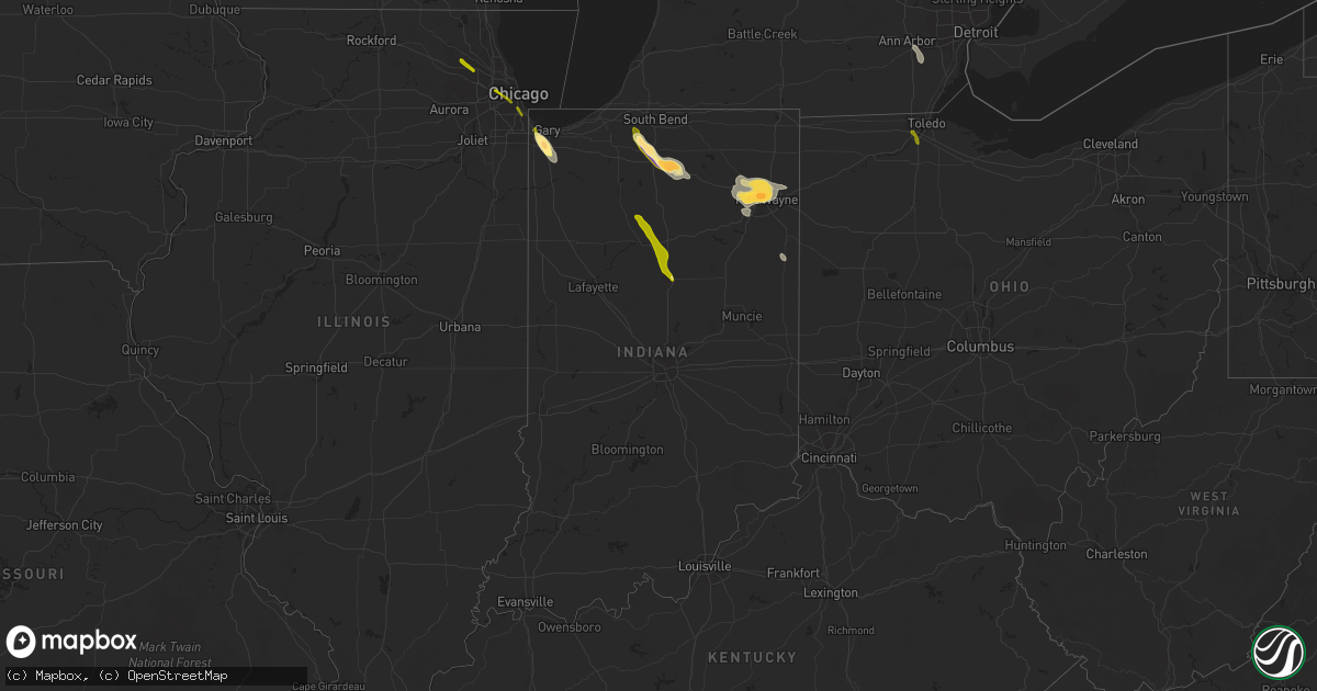
Hail Map in Indiana on June 27, 2013
Get this storm
June 27 map
$229
one time, instant access
Download today. No call, no setup
Keep the $229
Bought the map and want the full workflow? Apply the entire $229 to a subscription within 7 days. None of it is wasted.
Every map, not just this one
This buys you this map. Subscription and you get every map we run, in the markets you choose from a few cities to whole states to nationwide. Plus real-time alerts the moment a storm fires.
Contact data
Name, contact info, occupancy, even credit band for addresses in the footprint. You go from where it hit to who to call.
Become the source they trust
Unlimited branding weather history reports on demand. You already have the documented answer ready for the property owner, and you are the one who showed up with it.
Property data and RoofTrace estimates
Pull up any address you have got, its value and the exact code rules for that jurisdiction, straight from One Click Code. Then RoofTrace estimates the squares, pitch, and roof value, priced the way you price.
Storm reports in Indiana
Indiana
| Date | Description |
|---|---|
| 06/27/20136:58 PM CDT | Relayed by wsbt |
| 06/27/20136:54 PM CDT | A local report indicates 1.00 inch wind near MERRILLVILLE |
| 06/27/20136:50 PM CDT | Lasted for two minutes and was preceded by severe wind gusts. |
| 06/27/20136:46 PM CDT | Wind gusts lasted for around two minutes. |
| 06/27/20136:46 PM CDT | A few trees and power lines downed. Time estimated per other report of high winds in meerillville. |
| 06/27/20136:42 PM CDT | Relayed by wndu |
| 06/27/20136:38 PM CDT | Several reports of quarter to half dollar sized hail relayed by wsbt |
| 06/27/20136:36 PM CDT | Measured by the awos at the gary airport |
| 06/27/20135:55 PM CDT | Tree limbs and patio furniture blown over. Time estimated from radar. |
| 06/27/20135:05 PM CDT | Dime size hail also reported. |
| 06/27/20135:05 PM CDT | Ponding of water along road side as well. Located on us highway 31 |
| 06/27/20134:45 PM CDT | A local report indicates 1.00 inch wind near BUNKER HILL |
| 06/27/20134:41 PM CDT | A local report indicates 58 MPH wind near GRISSOM AFB |
| 06/27/20134:25 PM CDT | A local report indicates 1.00 inch wind near ADAMSBORO |
| 06/27/20134:25 PM CDT | A local report indicates 60 MPH wind near ADAMSBORO |
| 06/27/20134:05 PM CDT | Power lines down across sr 17 |
| 06/26/20138:55 PM CDT | Roof off of barn at s 000 rd and 800 s. Several trees down in the area. Corn flattened. Time estimated. |
| 06/26/20138:55 PM CDT | A local report indicates 1.00 inch wind near GENEVA |
| 06/26/20138:00 PM CDT | Law enforcement relayed report of a barn suffering severe damage. Roof blown off. |
| 06/26/20137:52 PM CDT | A local report indicates 1.75 inch wind near 2 ESE ARCOLA |
| 06/26/20137:51 PM CDT | Measured by ham on butler road |
| 06/26/20137:51 PM CDT | Large tree limbs down on bass road near hamilton rd |
| 06/26/20137:50 PM CDT | Measured at wfft studios |
| 06/26/20137:48 PM CDT | At wane studios |
| 06/26/20137:25 PM CDT | A local report indicates 1.00 inch wind near 2 E GOBLESVILLE |
| 06/26/20137:15 PM CDT | Two trees down in the road near the atwood fire station |
| 06/26/20137:15 PM CDT | One tree downed |
| 06/26/20137:06 PM CDT | One tree downed |
All States Impacted by Hail Map on June 27, 2013
Cities Impacted by Hail Map on June 27, 2013
- White Cloud, KS
- Rulo, NE
- Hiawatha, KS
- Robinson, KS
- Strawberry, AR
- Smithville, AR
- Cave City, AR
- Sulphur Rock, AR
- Lincoln, KS
- Sylvan Grove, KS
- Holton, KS
- New Haven, IN
- Churubusco, IN
- Huntertown, IN
- Columbia City, IN
- Arcola, IN
- Grabill, IN
- Fort Wayne, IN
- Roanoke, IN
- Tomahawk, WI
- Gleason, WI
- Manhattan, KS
- Leonardville, KS
- Riley, KS
- Randolph, KS
- Olsburg, KS
- Silver Lake, KS
- Topeka, KS
- Wamego, KS
- Saint George, KS
- Westmoreland, KS
- Frankfort, KS
- Onaga, KS
- Blue Rapids, KS
- Holyrood, KS
- Claflin, KS
- Griffith, IN
- Gary, IN
- Schererville, IN
- Merrillville, IN
- Crown Point, IN
- Deerbrook, WI
- Grandview, MO
- Lees Summit, MO
- Belton, MO
- Kansas City, MO
- Raymore, MO
- Cleveland, MO
- Peculiar, MO
- Fort Riley, KS
- Alta Vista, KS
- Green, KS
- Milford, KS
- Junction City, KS
- Ogden, KS
- Dwight, KS
- Albion, NE
- Hoisington, KS
- Bushton, KS
- Wilson, KS
- Dorrance, KS
- Manitowoc, WI
- Warsaw, IN
- Walkerton, IN
- Lakeville, IN
- Bremen, IN
- Etna Green, IN
- Plymouth, IN
- Bourbon, IN
- Atwood, IN
- North Liberty, IN
- Adams, NE
- Burr, NE
- Sterling, NE
- Cook, NE
- Douglas, NE
- Tecumseh, NE
- Highland, KS
- Craig, MO
- Forest City, MO
- Falls City, NE
- Troy, KS
- Inman, KS
- Lancaster, KS
- Two Rivers, WI
- Whitelaw, WI
- Reedsville, WI
- Rhinelander, WI
- Eagle River, WI
- Three Lakes, WI
- Milan, MI
- Ypsilanti, MI
- Willis, MI
- Bronwood, GA
- Dawson, GA
- Aniwa, WI
- Antigo, WI
- Kokomo, IN
- Hazelhurst, WI
- Harshaw, WI
- Lake Tomahawk, WI
- Brookville, KS
- Falun, KS
- Marquette, KS
- Mcpherson, KS
- Great Bend, KS
- Fond Du Lac, WI
- Firth, NE
- Highland, IN
- Crab Orchard, NE
- Tyronza, AR
- Marked Tree, AR
- Hammond, IN
- Beverly, KS
- Barnard, KS
- Beloit, KS
- Hunter, KS
- Bucyrus, KS
- Stilwell, KS
- Valley Falls, KS
- Nortonville, KS
- Minocqua, WI
- Woodruff, WI
- Pelican Lake, WI
- Russell, KS
- Hebron, IN
- Hobart, IN
- Ash Flat, AR
- Hardy, AR
- Nappanee, IN
- Leesburg, IN
- Perrysburg, OH
- Osborne, KS
- Tipton, KS
- Ellsworth, KS
- Downs, KS
- Glen Elder, KS
- Kewaunee, WI
- Champion, MI
- Republic, MI
- Plymouth, NE
- Fairbury, NE
- Jansen, NE
- Geneva, IN
- Berne, IN
- Greenwood, MO
- Lone Jack, MO
- Grain Valley, MO
- Leawood, KS
- Pleasant Hill, MO
- Independence, MO
- Harrisonville, MO
- Overland Park, KS
- Bay, AR
- Jonesboro, AR
- Weiner, AR
- Bono, AR
- Lake City, AR
- Harrisburg, AR
- Trumann, AR
- Black Rock, AR
- Cord, AR
- Saffell, AR
- Bunker Hill, KS
- Hutchinson, KS
- Buhler, KS
- Moundridge, KS
- Twelve Mile, IN
- Kewanna, IN
- Lucerne, IN
- Galveston, IN
- Onward, IN
- Logansport, IN
- Walton, IN
- Bunker Hill, IN
- Grissom Arb, IN
- Peru, IN
- Rushville, MO
- Atchison, KS
- Denton, KS
- Saint Joseph, MO
- Wathena, KS
- De Kalb, MO
- Bendena, KS
- Sprague, NE
- Auburn, NE
- Table Rock, NE
- Verdon, NE
- Milford, NE
- Martell, NE
- Denton, NE
- Elk Creek, NE
- Crete, NE
- Shubert, NE
- Dorchester, NE
- Stella, NE
- Humboldt, NE
- Bennet, NE
- Steinauer, NE
- Pleasant Dale, NE
- Johnson, NE
- Dawson, NE
- Cortland, NE
- Seward, NE
- Roca, NE
- Hallam, NE
- Lincoln, NE
- Panama, NE
- Hickman, NE
- Petersburg, NE
- East Chicago, IN
- Schaumburg, IL
- Barrington, IL
- Hoffman Estates, IL
- Chicago, IL
- Berwyn, IL
- River Forest, IL
- Maywood, IL
- Bellwood, IL
- Forest Park, IL
- Melrose Park, IL
- Cicero, IL
- Oak Park, IL
- Maumee, OH
- Toledo, OH
- Salem, NE
- Morrill, KS
- White City, KS
- Council Grove, KS
- Alma, KS
- Effingham, KS
- Saint Marys, KS
- Delia, KS
- Rossville, KS
- Casco, WI
- Luxemburg, WI
- Summit Lake, WI
- Poughkeepsie, AR
- Cherokee Village, AR
- Spalding, NE
- Greeley, NE


