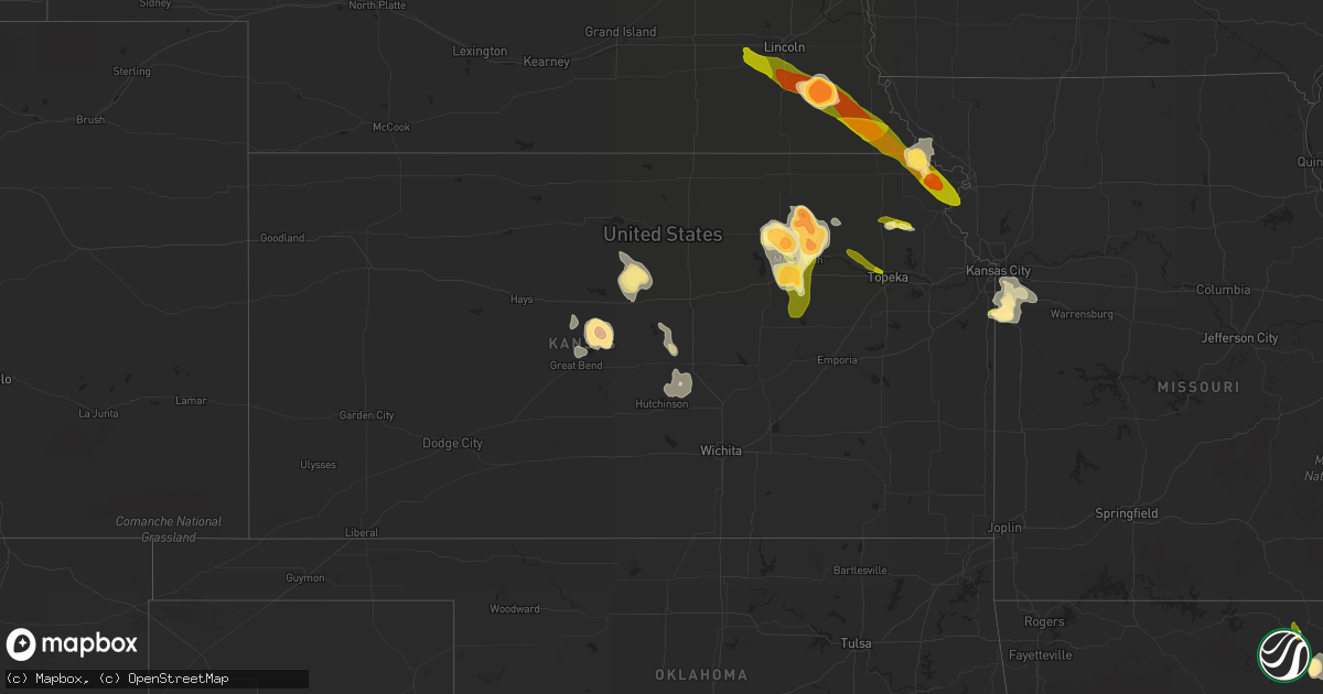
Hail Map in Kansas on June 27, 2013
Get this storm
June 27 map
$229
one time, instant access
Download today. No call, no setup
Keep the $229
Bought the map and want the full workflow? Apply the entire $229 to a subscription within 7 days. None of it is wasted.
Every map, not just this one
This buys you this map. Subscription and you get every map we run, in the markets you choose from a few cities to whole states to nationwide. Plus real-time alerts the moment a storm fires.
Contact data
Name, contact info, occupancy, even credit band for addresses in the footprint. You go from where it hit to who to call.
Become the source they trust
Unlimited branding weather history reports on demand. You already have the documented answer ready for the property owner, and you are the one who showed up with it.
Property data and RoofTrace estimates
Pull up any address you have got, its value and the exact code rules for that jurisdiction, straight from One Click Code. Then RoofTrace estimates the squares, pitch, and roof value, priced the way you price.
Storm reports in Kansas
Kansas
| Date | Description |
|---|---|
| 06/27/20136:56 PM CDT | A local report indicates 58 MPH wind near MEDICINE LODGE |
| 06/27/20136:55 PM CDT | A local report indicates 62 MPH wind near 4 NNW CLEARWATER |
| 06/27/20136:54 PM CDT | A local report indicates 58 MPH wind near JABARA AIRPORT |
| 06/27/20136:54 PM CDT | Trained spotter estimates winds of 75 to 80 mph. |
| 06/27/20136:54 PM CDT | 5 inch diameter trees limbs down. |
| 06/27/20136:54 PM CDT | Trained spotter reports an 8 to 12 inch diameter tree was uprooted with an estimated 75 to 80 mph gust. |
| 06/27/20136:53 PM CDT | A local report indicates 59 MPH wind near MCCONNELL AIR FORCE BAS |
| 06/27/20136:50 PM CDT | Tree limbs were blown down. |
| 06/27/20136:50 PM CDT | 70mph wind gusts reported near maize and 21st. |
| 06/27/20136:49 PM CDT | Several large trees and tree limbs down across town and shingles blown off roofs. |
| 06/27/20136:47 PM CDT | A local report indicates 80 MPH wind near 2 E HARPER |
| 06/27/20136:44 PM CDT | Measured 2.25 inch hail |
| 06/27/20136:41 PM CDT | A local report indicates 58 MPH wind near MEDICINE LODGE |
| 06/27/20136:40 PM CDT | Spotter estimates 65 to 70 mph winds and 2 to 3 inch tree limbs down. |
| 06/27/20136:38 PM CDT | A local report indicates 60 MPH wind near 5 NW BENTLEY |
| 06/27/20136:37 PM CDT | Measured 71mph wind gust at 21st and tyler. |
| 06/27/20136:37 PM CDT | A local report indicates 63 MPH wind near NEWTON AIRPORT |
| 06/27/20136:30 PM CDT | 2 inch trees down with winds estimated at 60 mph near willowdale. Time estimated from radar. |
| 06/27/20136:21 PM CDT | Kake tv reported 60mph winds in hesston. |
| 06/27/20136:20 PM CDT | A local report indicates 60 MPH wind near HESSTON |
| 06/27/20136:19 PM CDT | A local report indicates 60 MPH wind near HALSTEAD |
| 06/27/20136:17 PM CDT | A local report indicates 59 MPH wind near HUTCHINSON AIRPORT |
| 06/27/20136:04 PM CDT | A local report indicates 60 MPH wind near 4 SE CULLISON |
| 06/27/20136:00 PM CDT | Measured wind gust of 92mph prior to anemometer snapping. Numerous large trees and power lines down all across town. |
| 06/27/20135:55 PM CDT | Delayed report. Time based on radar. |
| 06/27/20135:55 PM CDT | 55 to 60 mph winds from pratt to coats |
| 06/27/20135:51 PM CDT | A local report indicates 80 MPH wind near 1 W MCPHERSON |
| 06/27/20135:51 PM CDT | Several trees down in the town of mcpherson. |
| 06/27/20135:45 PM CDT | Spotter was on north side of town. |
| 06/27/20135:45 PM CDT | Hay shed was blown down. Time adjusted by radar. |
| 06/27/20135:41 PM CDT | 70 to 80 mph winds on the north side of mcpherson |
| 06/27/20135:40 PM CDT | A local report indicates 70 MPH wind near 4 NW MCPHERSON |
| 06/27/20135:33 PM CDT | Very limited visibility due to rain and winds. |
| 06/27/20135:31 PM CDT | 2 to 3 inch diameter tree limbs were blown down. |
| 06/27/20135:30 PM CDT | A local report indicates 60 MPH wind near GREENSBURG |
| 06/27/20135:30 PM CDT | Also estimated 60-70 mph winds knocked down trees all over town. Delayed report. |
| 06/27/20135:29 PM CDT | Empty semi trailer was blown over at mile marker 102 on highway 54. |
| 06/27/20135:17 PM CDT | 3 power poles were snapped due to high winds from the thunderstorms on highway 54. |
| 06/27/20135:15 PM CDT | A semi was blown over by high winds. |
| 06/27/20135:15 PM CDT | Power poles and 12 to 15 inch tree downed in the town of falun. Delayed report with time based on radar. |
| 06/27/20135:13 PM CDT | A power pole was blown down in bucklin. |
| 06/27/20135:11 PM CDT | 3 to 4 inch limbs down. |
| 06/27/20135:06 PM CDT | A local report indicates 60 MPH wind near 3 S FORD |
| 06/27/20135:02 PM CDT | A local report indicates 73 MPH wind near 5 S BEVERLY |
| 06/27/20135:00 PM CDT | Tree damage on the east side of town. |
| 06/27/20135:00 PM CDT | Power poles downed. Delayed report with time based on radar. |
| 06/27/20134:55 PM CDT | 12 inch diameter tree blown over. |
| 06/27/20134:53 PM CDT | A local report indicates 74 MPH wind near ELLSWORTH |
| 06/27/20134:50 PM CDT | 3 inch tree branches broken. |
| 06/27/20134:49 PM CDT | A local report indicates 60 MPH wind near 6 WSW GLENDALE |
| 06/27/20134:47 PM CDT | A local report indicates 64 MPH wind near ELLSWORTH |
| 06/27/20134:46 PM CDT | 4 inch tree branches broken in westfall |
| 06/27/20134:41 PM CDT | A local report indicates 1.00 inch wind near W BUSHTON |
| 06/27/20134:40 PM CDT | A local report indicates 61 MPH wind near ELLSWORTH |
| 06/27/20134:39 PM CDT | Measured by ksn weatherlab network station at the otis-bison high school. |
| 06/27/20134:37 PM CDT | A local report indicates 4.25 inch wind near 5 N CLAFLIN |
| 06/27/20134:37 PM CDT | 70 to 80 mph winds with heavy rain in the city of lincoln. |
| 06/27/20134:35 PM CDT | Surface observation from dodge city measured 60 mph wind. |
| 06/27/20134:31 PM CDT | A local report indicates 60 MPH wind near 2 NW DODGE CITY |
| 06/27/20134:30 PM CDT | Powerlines down. Time estimated from radar |
| 06/27/20134:25 PM CDT | Wind driven hail with gusts to 80mph. |
| 06/27/20134:25 PM CDT | One and three quarter inch hail was blown by the winds. |
| 06/27/20134:24 PM CDT | A local report indicates 80 MPH wind near 4 W LINCOLN |
| 06/27/20134:19 PM CDT | Branches and debris blown through the air over highway 18. |
| 06/27/20134:15 PM CDT | Large tree limbs were down and a window was blown out at a residence in ingalls. Report received via social media. |
| 06/27/20134:15 PM CDT | A local report indicates 70 MPH wind near SYLVAN GROVE |
| 06/27/20134:10 PM CDT | Pea size hail was also reported |
| 06/27/20134:05 PM CDT | Very strong winds were also noted but no speed reported. |
| 06/27/20134:04 PM CDT | A local report indicates 1.00 inch wind near 4 N ASH GROVE |
| 06/27/20134:04 PM CDT | A local report indicates 1.00 inch wind near 3 N ASH GROVE |
| 06/27/20134:01 PM CDT | A local report indicates 1.00 inch wind near HUNTER |
| 06/27/20133:57 PM CDT | Estimated wind gusts of 70 to 80 mph |
| 06/27/20133:55 PM CDT | A local report indicates 1.00 inch wind near HUNTER |
| 06/27/20133:54 PM CDT | A local report indicates 65 MPH wind near 4 NW ASH GROVE |
| 06/27/20133:39 PM CDT | A local report indicates 1.00 inch wind near TIPTON |
| 06/27/20133:32 PM CDT | A local report indicates 1.00 inch wind near 1 N TIPTON |
| 06/27/20133:24 PM CDT | A local report indicates 1.00 inch wind near 8 E OSBORNE |
| 06/27/20139:24 AM CDT | A local report indicates 75 MPH wind near 2 NW WHITE CLOUD |
| 06/27/20139:24 AM CDT | A local report indicates 2.00 inch wind near 2 NW WHITE CLOUD |
| 06/27/201312:25 AM CDT | Also power flashes in south part of town. |
| 06/27/201312:20 AM CDT | Power lines reported down. |
| 06/27/201312:15 AM CDT | A local report indicates 70 MPH wind near 1 N ARMA |
| 06/26/201311:48 PM CDT | Power lines reported down near devon. |
| 06/26/201311:00 PM CDT | Winds estimated at 60-70 mph winds. Trees and power lines down. Town without power. Delayed report. |
| 06/26/201311:00 PM CDT | Estimated 60-70 mph winds. Trees and power lines down. Town without power. Delayed report. |
| 06/26/201311:00 PM CDT | Estimated 60-70 mph winds. Trees down and power lines down. Town without power. Windows broken. Delayed report. |
| 06/26/201310:02 PM CDT | A local report indicates 70 MPH wind near 3 N NEOSHO RAPIDS |
| 06/26/201310:00 PM CDT | Tree and tree limbs down. Tree approximately two feet in diameter. Tree limbs up to ten inches in diameter. Time estimated. From social media. |
| 06/26/201310:00 PM CDT | A local report indicates 60 MPH wind near 2 E EMPORIA |
| 06/26/20139:59 PM CDT | Small branches down |
| 06/26/20139:51 PM CDT | A local report indicates 1.00 inch wind near N LAWRENCE |
| 06/26/20139:50 PM CDT | Mostly dime size with a few quarter size hailstones. |
| 06/26/20139:33 PM CDT | Picture and report from social media. Time radar estimated. |
| 06/26/20139:15 PM CDT | A local report indicates 1.00 inch wind near 2 E PARKERVILLE |
| 06/26/20139:00 PM CDT | Wind gusts estimated 60 to 70 mph |
| 06/26/20138:50 PM CDT | Off duty nws employee reported widespread major tree damage across west wichita...including some trees on homes. |
| 06/26/20138:49 PM CDT | Dime size hail was also reported. |
| 06/26/20138:47 PM CDT | A local report indicates 60 MPH wind near 3 ESE SILVER LAKE |
| 06/26/20138:43 PM CDT | A local report indicates 69 MPH wind near JUNCTION CITY |
| 06/26/20138:39 PM CDT | A local report indicates 1.00 inch wind near 2 NE SILVER LAKE |
| 06/26/20138:38 PM CDT | Quarter hail and up to the size of golfballs. Estimated winds of 55 mph. |
| 06/26/20138:36 PM CDT | Delayed report. Three-quarter inch to one-inch diameter hail reported. |
| 06/26/20138:27 PM CDT | A local report indicates 1.00 inch wind near 6 NW MANHATTAN |
| 06/26/20138:13 PM CDT | Picture and report from social media. Time radar estimated. |
| 06/26/20138:06 PM CDT | Report via social media photo. |
| 06/26/20138:06 PM CDT | A local report indicates 1.75 inch wind near 5 N KEATS |
| 06/26/20138:06 PM CDT | Mostly dime size with a few quarter size hailstones. |
| 06/26/20138:02 PM CDT | Hail to the size of golfballs nw of flush. Picture and report provided on social media. Time radar estimated. |
| 06/26/20137:54 PM CDT | Two foot diameter knocked over in town. |
| 06/26/20137:52 PM CDT | Numerous large trees down around town and a traffic light was also blown down on north side of town. |
| 06/26/20137:49 PM CDT | A local report indicates 1.00 inch wind near ESE RANDOLPH |
| 06/26/20137:45 PM CDT | A local report indicates 1.50 inch wind near 3 E LEONARDVILLE |
| 06/26/20137:43 PM CDT | A local report indicates 1.75 inch wind near 8 SSW WESTMORELAND |
| 06/26/20137:41 PM CDT | A local report indicates 58 MPH wind near ARKANSAS CITY |
| 06/26/20137:40 PM CDT | Tree damage being reported in town. |
| 06/26/20137:36 PM CDT | I-35 at state line. Reported by kwtv. |
| 06/26/20137:32 PM CDT | A local report indicates 70 MPH wind near WINFIELD |
| 06/26/20137:32 PM CDT | A local report indicates 63 MPH wind near STROTHER FIELD AIRPORT |
| 06/26/20137:25 PM CDT | Several large tree limbs were also knocked down by the winds. |
| 06/26/20137:22 PM CDT | Numerous large tree down in town. |
| 06/26/20137:22 PM CDT | Mostly quarter size with a few bigger stones up to 1.25 inches |
| 06/26/20137:20 PM CDT | 6 inch diameter tree limbs down in the city. |
| 06/26/20137:17 PM CDT | Power poles knocked down from thunderstorm wind gusts. |
| 06/26/20137:16 PM CDT | Numerous tree limbs knocked down by thunderstorm wind gusts in udall. |
| 06/26/20137:15 PM CDT | A local report indicates 1.00 inch wind near ARRINGTON |
| 06/26/20137:14 PM CDT | A local report indicates 70 MPH wind near 1 NW UDALL |
| 06/26/20137:11 PM CDT | Several 4 to 5 inch tree limbs knocked down. |
| 06/26/20137:10 PM CDT | Estimated quarter size but some may have been larger. |
| 06/26/20137:10 PM CDT | Off duty nws employee reported widespread major tree damage across west wichita...including some trees on homes. |
| 06/26/20137:10 PM CDT | 8 inch diameter tree down. Reported by nws employee. Delayed report |
| 06/26/20137:07 PM CDT | A local report indicates 1.25 inch wind near 6 E HOLTON |
| 06/26/20137:07 PM CDT | Hail up to the size of golfballs. Report from social media. Time radar estimated. |
| 06/26/20137:05 PM CDT | A local report indicates 1.00 inch wind near NNW WESTMORELAND |
| 06/26/20137:02 PM CDT | Trained spotter reports scattered elm trees down of 2 to 3 feet in diameter from 120th to 127th east on douglas. |
| 06/26/20137:02 PM CDT | A local report indicates 69 MPH wind near MCCONNELL AIR FORCE BAS |
| 06/26/20137:02 PM CDT | Fireworks tent blown over at 167th and us54 in west wichita. |
| 06/26/20137:00 PM CDT | Several baggage cars flipped over. Smaller federal express cargo plane sustained wing damage and was turned 180 degrees. 3 overhead garage doors were blown in. |
| 06/26/20137:00 PM CDT | A local report indicates 89 MPH wind near WICHITA MID CONTINENT A |
All States Impacted by Hail Map on June 27, 2013
Cities Impacted by Hail Map on June 27, 2013
- White Cloud, KS
- Rulo, NE
- Hiawatha, KS
- Robinson, KS
- Strawberry, AR
- Smithville, AR
- Cave City, AR
- Sulphur Rock, AR
- Lincoln, KS
- Sylvan Grove, KS
- Holton, KS
- New Haven, IN
- Churubusco, IN
- Huntertown, IN
- Columbia City, IN
- Arcola, IN
- Grabill, IN
- Fort Wayne, IN
- Roanoke, IN
- Tomahawk, WI
- Gleason, WI
- Manhattan, KS
- Leonardville, KS
- Riley, KS
- Randolph, KS
- Olsburg, KS
- Silver Lake, KS
- Topeka, KS
- Wamego, KS
- Saint George, KS
- Westmoreland, KS
- Frankfort, KS
- Onaga, KS
- Blue Rapids, KS
- Holyrood, KS
- Claflin, KS
- Griffith, IN
- Gary, IN
- Schererville, IN
- Merrillville, IN
- Crown Point, IN
- Deerbrook, WI
- Grandview, MO
- Lees Summit, MO
- Belton, MO
- Kansas City, MO
- Raymore, MO
- Cleveland, MO
- Peculiar, MO
- Fort Riley, KS
- Alta Vista, KS
- Green, KS
- Milford, KS
- Junction City, KS
- Ogden, KS
- Dwight, KS
- Albion, NE
- Hoisington, KS
- Bushton, KS
- Wilson, KS
- Dorrance, KS
- Manitowoc, WI
- Warsaw, IN
- Walkerton, IN
- Lakeville, IN
- Bremen, IN
- Etna Green, IN
- Plymouth, IN
- Bourbon, IN
- Atwood, IN
- North Liberty, IN
- Adams, NE
- Burr, NE
- Sterling, NE
- Cook, NE
- Douglas, NE
- Tecumseh, NE
- Highland, KS
- Craig, MO
- Forest City, MO
- Falls City, NE
- Troy, KS
- Inman, KS
- Lancaster, KS
- Two Rivers, WI
- Whitelaw, WI
- Reedsville, WI
- Rhinelander, WI
- Eagle River, WI
- Three Lakes, WI
- Milan, MI
- Ypsilanti, MI
- Willis, MI
- Bronwood, GA
- Dawson, GA
- Aniwa, WI
- Antigo, WI
- Kokomo, IN
- Hazelhurst, WI
- Harshaw, WI
- Lake Tomahawk, WI
- Brookville, KS
- Falun, KS
- Marquette, KS
- Mcpherson, KS
- Great Bend, KS
- Fond Du Lac, WI
- Firth, NE
- Highland, IN
- Crab Orchard, NE
- Tyronza, AR
- Marked Tree, AR
- Hammond, IN
- Beverly, KS
- Barnard, KS
- Beloit, KS
- Hunter, KS
- Bucyrus, KS
- Stilwell, KS
- Valley Falls, KS
- Nortonville, KS
- Minocqua, WI
- Woodruff, WI
- Pelican Lake, WI
- Russell, KS
- Hebron, IN
- Hobart, IN
- Ash Flat, AR
- Hardy, AR
- Nappanee, IN
- Leesburg, IN
- Perrysburg, OH
- Osborne, KS
- Tipton, KS
- Ellsworth, KS
- Downs, KS
- Glen Elder, KS
- Kewaunee, WI
- Champion, MI
- Republic, MI
- Plymouth, NE
- Fairbury, NE
- Jansen, NE
- Geneva, IN
- Berne, IN
- Greenwood, MO
- Lone Jack, MO
- Grain Valley, MO
- Leawood, KS
- Pleasant Hill, MO
- Independence, MO
- Harrisonville, MO
- Overland Park, KS
- Bay, AR
- Jonesboro, AR
- Weiner, AR
- Bono, AR
- Lake City, AR
- Harrisburg, AR
- Trumann, AR
- Black Rock, AR
- Cord, AR
- Saffell, AR
- Bunker Hill, KS
- Hutchinson, KS
- Buhler, KS
- Moundridge, KS
- Twelve Mile, IN
- Kewanna, IN
- Lucerne, IN
- Galveston, IN
- Onward, IN
- Logansport, IN
- Walton, IN
- Bunker Hill, IN
- Grissom Arb, IN
- Peru, IN
- Rushville, MO
- Atchison, KS
- Denton, KS
- Saint Joseph, MO
- Wathena, KS
- De Kalb, MO
- Bendena, KS
- Sprague, NE
- Auburn, NE
- Table Rock, NE
- Verdon, NE
- Milford, NE
- Martell, NE
- Denton, NE
- Elk Creek, NE
- Crete, NE
- Shubert, NE
- Dorchester, NE
- Stella, NE
- Humboldt, NE
- Bennet, NE
- Steinauer, NE
- Pleasant Dale, NE
- Johnson, NE
- Dawson, NE
- Cortland, NE
- Seward, NE
- Roca, NE
- Hallam, NE
- Lincoln, NE
- Panama, NE
- Hickman, NE
- Petersburg, NE
- East Chicago, IN
- Schaumburg, IL
- Barrington, IL
- Hoffman Estates, IL
- Chicago, IL
- Berwyn, IL
- River Forest, IL
- Maywood, IL
- Bellwood, IL
- Forest Park, IL
- Melrose Park, IL
- Cicero, IL
- Oak Park, IL
- Maumee, OH
- Toledo, OH
- Salem, NE
- Morrill, KS
- White City, KS
- Council Grove, KS
- Alma, KS
- Effingham, KS
- Saint Marys, KS
- Delia, KS
- Rossville, KS
- Casco, WI
- Luxemburg, WI
- Summit Lake, WI
- Poughkeepsie, AR
- Cherokee Village, AR
- Spalding, NE
- Greeley, NE


