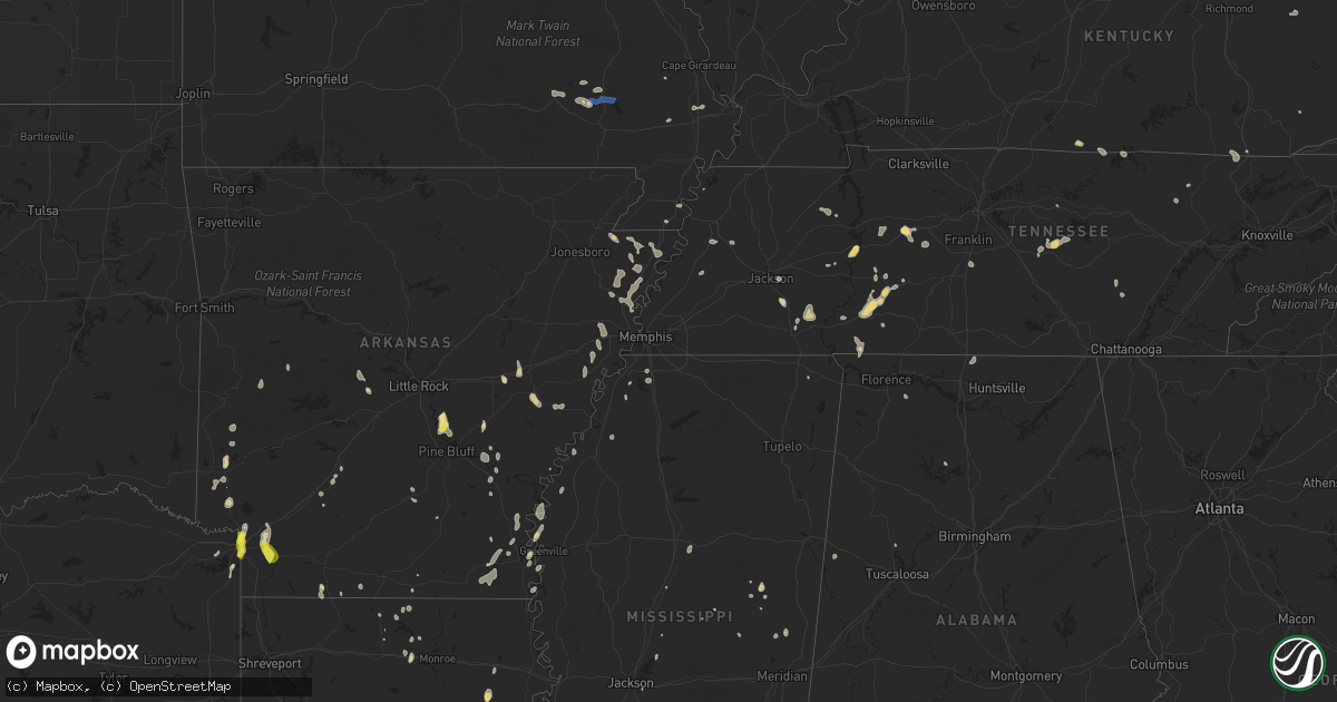
Hail Map in Tennessee on June 26, 2022
Get this storm
June 26 map
$229
one time, instant access
Download today. No call, no setup
Keep the $229
Bought the map and want the full workflow? Apply the entire $229 to a subscription within 7 days. None of it is wasted.
Every map, not just this one
This buys you this map. Subscription and you get every map we run, in the markets you choose from a few cities to whole states to nationwide. Plus real-time alerts the moment a storm fires.
Contact data
Name, contact info, occupancy, even credit band for addresses in the footprint. You go from where it hit to who to call.
Become the source they trust
Unlimited branding weather history reports on demand. You already have the documented answer ready for the property owner, and you are the one who showed up with it.
Property data and RoofTrace estimates
Pull up any address you have got, its value and the exact code rules for that jurisdiction, straight from One Click Code. Then RoofTrace estimates the squares, pitch, and roof value, priced the way you price.
Storm reports in Tennessee
Tennessee
| Date | Description |
|---|---|
| 06/26/20225:15 PM CDT | County dept of highways reports tree down along highway 90. |
| 06/26/20223:12 AM CDT | At 812 PM EDT, a severe thunderstorm was located near Sweetwater, moving southeast at 20 mph. HAZARD...60 mph wind gusts. SOURCE...Radar indicated. IMPACT...Expect damage to roofs, siding, and trees. Locations impacted include... Sweetwater, Madisonville, Englewood, Vonore, Niota, Philadelphia, Mount Vernon, Murray Store, Fort Loudon State Park and McGee Carson Peninsula.This includes Interstate 75 in Tennessee between mile markers 55 and69. |
| 06/26/202212:28 AM CDT | At 528 PM EDT, a severe thunderstorm was located 14 miles northwest of Wartburg, moving southeast at 10 mph. HAZARD...60 mph wind gusts and quarter size hail. SOURCE...Radar indicated. IMPACT...Hail damage to vehicles is expected. Expect wind damage to roofs, siding, and trees. Locations impacted include... Sunbright, High Point, Deerlodge and Frozen Head State Park. |
| 06/25/202210:13 PM CDT | At 313 PM CDT, a severe thunderstorm was located near Waynesboro, moving southeast at 10 mph. HAZARD...60 mph wind gusts and quarter size hail. SOURCE...Radar indicated. IMPACT...Hail damage to vehicles is expected. Expect wind damage to roofs, siding, and trees. Locations impacted include... Waynesboro. |
| 06/25/202210:05 PM CDT | At 305 PM CDT, a severe thunderstorm was located 7 miles southwest of Dickson, moving southeast at 25 mph. HAZARD...60 mph wind gusts and quarter size hail. SOURCE...Radar indicated. IMPACT...Hail damage to vehicles is expected. Expect wind damage to roofs, siding, and trees. Locations impacted include... Dickson, Centerville, Lyles, Bon Aqua, Nunnelly and Pinewood. This includes Interstate 40 between mile markers 158 and 173. |
| 06/25/20229:31 PM CDT | At 231 PM CDT, a severe thunderstorm was located near Tompkinsville, moving east at 20 mph. HAZARD...60 mph wind gusts and quarter size hail. SOURCE...Radar indicated. IMPACT...Hail damage to vehicles is expected. Expect wind damage to roofs, siding, and trees. This severe thunderstorm will be near... Tompkinsville around 240 PM CDT. |
| 06/25/20227:30 PM CDT | Tree down near county road 325 and hwy 11. Time estimated by radar. |
| 06/25/20227:26 PM CDT | Downed tree blocking the road on county road 326. Time estimated by radar. |
| 06/25/20227:20 PM CDT | Few trees down near murrays chapel. Time estimated by radar. |
All States Impacted by Hail Map on June 26, 2022
Cities Impacted by Hail Map on June 26, 2022
- Sherrill, AR
- Louisa, KY
- Dyersburg, TN
- Halls, TN
- Henning, TN
- Ripley, TN
- Camden, TN
- Hestand, KY
- Celina, TN
- Newcomb, TN
- Jellico, TN
- Pine Knot, KY
- Williamsburg, KY
- Smithville, TN
- Woodbury, TN
- Liberty, TN
- Dowelltown, TN
- Dumas, AR
- Nunnelly, TN
- Dickson, TN
- Bon Aqua, TN
- Hernando, MS
- Downsville, LA
- Whitewater, MO
- Manila, AR
- Etowah, AR
- Olivehill, TN
- Savannah, TN
- Lake Village, AR
- Waverly, TN
- McEwen, TN
- Hurricane Mills, TN
- Humphrey, AR
- Widener, AR
- Hughes, AR
- Finger, TN
- Morris Chapel, TN
- Bethel Springs, TN
- Enville, TN
- Adamsville, TN
- Throckmorton, TX
- Burleson, TX
- Clarksdale, MS
- Lockesburg, AR
- Luxora, AR
- Blytheville, AR
- Winnsboro, LA
- Louisville, MS
- Strong, AR
- Mill Spring, MO
- Mineral Wells, TX
- Whitt, TX
- Graford, TX
- Weatherford, TX
- Perrin, TX
- Earle, AR
- Heth, AR
- Allons, TN
- Deer Lodge, TN
- Ridgely, TN
- Arkadelphia, AR
- Lobelville, TN
- Holladay, TN
- Sugar Tree, TN
- Kingsland, AR
- Altheimer, AR
- Stuttgart, AR
- Texarkana, TX
- Texarkana, AR
- Glen, MS
- Graham, TX
- Woodson, TX
- Carthage, MS
- Gilbertown, AL
- Jackson, TN
- Dubach, LA
- Queen City, TX
- Hollow Rock, TN
- Mansfield, TN
- Snow Lake, AR
- Pearl, MS
- Marked Tree, AR
- Lepanto, AR
- Tyronza, AR
- Benton, AR
- Paron, AR
- Gould, AR
- Osceola, AR
- Keiser, AR
- Jeanerette, LA
- Linden, TN
- Jacksboro, TX
- Kimbolton, OH
- Marvell, AR
- Poplar Grove, AR
- Waynesboro, TN
- Piedmont, MO
- Patterson, MO
- Lyles, TN
- Essex, MO
- Ethelsville, AL
- Prescott, AR
- Montrose, AR
- Henderson, TN
- Hohenwald, TN
- Roscoe, TX
- Brush Creek, TN
- Gordonsville, TN
- Flat Lick, KY
- Hayti, MO
- Caruthersville, MO
- Natchez, MS
- Roxie, MS
- Mound Bayou, MS
- Pikeville, TN
- Gurdon, AR
- Logan, AL
- Crane Hill, AL
- Dunlap, TN
- Columbia, TN
- Spring Hill, TN
- Selmer, TN
- Pinson, TN
- Marks, MS
- Clifton, TN
- Mathias, WV
- Lost City, WV
- Readyville, TN
- Tompkinsville, KY
- Gamaliel, KY
- De Queen, AR
- Dermott, AR
- Brickeys, AR
- Forrest City, AR
- Marianna, AR
- Parks, AR
- Abbeville, LA
- Darden, TN
- Lexington, TN
- Marion, LA
- Van Buren, MO
- Ellington, MO
- Rugby, TN
- Robbins, TN
- Greenville, MS
- Northport, AL
- Wellton, AZ
- Warren, AR
- Bassfield, MS
- De Valls Bluff, AR
- Biscoe, AR
- New Iberia, LA
- Broussard, LA
- Youngsville, LA
- Newcastle, TX
- Kaplan, LA
- Lake Charles, LA
- Sumrall, MS
- Albany, LA
- Hammond, LA
- Holden, LA
- Springfield, LA
- Port Allen, LA
- Saint Martinville, LA
- Bluffton, AR
- Monette, AR
- Lake City, AR
- Leighton, AL
- Tucker, AR
- England, AR
- Redfield, AR
- Jefferson, AR
- Emerson, AR
- Albany, TX
- Dell, AR
- Leachville, AR
- Westlake, LA
- Sulphur, LA
- Centerville, TN
- Clarendon, AR
- Cotton Plant, AR
- Brinkley, AR
- Horatio, AR
- De Witt, AR
- Tunica, MS
- Sikeston, MO
- Beattyville, KY
- Rogers, KY
- Campton, KY
- Steele, MO
- Bryson, TX
- Salome, AZ
- Friendship, TN
- Holly Grove, AR
- Umpire, AR
- Mena, AR
- Orange, TX
- Newellton, LA
- Rohwer, AR
- Benoit, MS
- De Kalb, MS
- Garland City, AR
- Fouke, AR
- Colorado City, TX
- Turrell, AR
- Bassett, AR
- Wilson, AR
- Joiner, AR
- Gilmore, AR
- Dyess, AR
- Jonesville, LA
- Iowa, LA
- Parsons, TN
- Branchland, WV
- East Lynn, WV
- Stephenville, TX
- Bluff Dale, TX
- Mendenhall, MS
- Magee, MS
- Kilmichael, MS
- Winona, MS
- Ashdown, AR
- Ovett, MS
- Walker, LA
- El Dorado, AR
- Junction City, AR
- Greenville, MO
- Ogden, AR
- Vidor, TX
- Mize, MS
- Mount Olive, MS
- Bernice, LA
- Farmerville, LA
- Raleigh, MS
- Erath, LA
- Eudora, AR
- Brandon, MS
- McGehee, AR
- Vinegar Bend, AL
- Picayune, MS
- Bay Saint Louis, MS
- Preston, MS
- Tolar, TX
- Lutts, TN
- Hattiesburg, MS
- Portland, AR
- Parkdale, AR
- Hamburg, AR
- Wilton, AR
- Hooks, TX
- Maud, TX
- Athens, AL
- Ardmore, AL
- Elkmont, AL
- Toney, AL
- Gilbert, LA
- Philadelphia, MS
- Waterloo, AL
- Haynesville, LA
- Delcambre, LA
- Calhoun, LA
- Williamsville, MO
- Lewisville, AR
- Fulton, AR
- Jena, LA
- Durant, MS
- Angie, LA
- Paulding, MS
- Canton, MS
- Choudrant, LA
- Delhi, LA
- Pinola, MS
- Spearsville, LA
- Wappapello, MO


