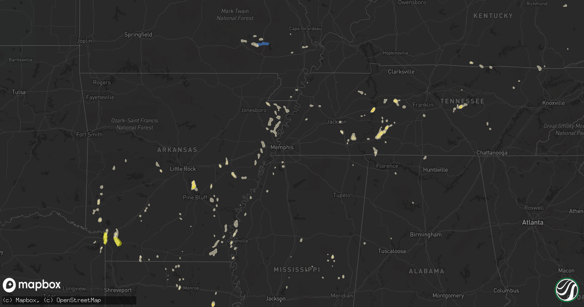
Hail Map in Arkansas on June 26, 2022
Get this storm
June 26 map
$229
one time, instant access
Download today. No call, no setup
Keep the $229
Bought the map and want the full workflow? Apply the entire $229 to a subscription within 7 days. None of it is wasted.
Every map, not just this one
This buys you this map. Subscription and you get every map we run, in the markets you choose from a few cities to whole states to nationwide. Plus real-time alerts the moment a storm fires.
Contact data
Name, contact info, occupancy, even credit band for addresses in the footprint. You go from where it hit to who to call.
Become the source they trust
Unlimited branding weather history reports on demand. You already have the documented answer ready for the property owner, and you are the one who showed up with it.
Property data and RoofTrace estimates
Pull up any address you have got, its value and the exact code rules for that jurisdiction, straight from One Click Code. Then RoofTrace estimates the squares, pitch, and roof value, priced the way you price.
Storm reports in Arkansas
Arkansas
| Date | Description |
|---|---|
| 06/26/20222:32 AM CDT | At 732 PM CDT, a severe thunderstorm was located near Lockesburg, or 8 miles southwest of Dierks, moving south at 10 mph. HAZARD...60 mph wind gusts and penny size hail. SOURCE...Radar indicated. IMPACT...Expect damage to roofs, siding, and trees. Locations impacted include... De Queen, Ashdown, Mineral Springs, Dierks, Lockesburg, Wilton, Tollette, Ben Lomond, Saratoga, Oak Grove, Silver Ridge, Geneva, Central, Lebanon, Arden, Provo, Browntown, Bellview and Bright Star. |
| 06/25/202211:52 PM CDT | At 452 PM CDT, a severe thunderstorm was located over Avon, moving southeast at 10 mph. HAZARD...60 mph wind gusts and penny size hail. SOURCE...Radar indicated. IMPACT...Expect damage to roofs, siding, and trees. This severe thunderstorm will be near... Hollandale and Estill around 530 PM CDT. |
| 06/25/202210:27 PM CDT | At 327 PM CDT, a severe thunderstorm was located near Hensley Island, or 19 miles north of Pine Bluff, moving southeast at 5 mph. HAZARD...60 mph wind gusts and quarter size hail. SOURCE...Radar indicated. IMPACT...Hail damage to vehicles is expected. Expect wind damage to roofs, siding, and trees. Locations impacted include... Pine Bluff... White Hall... England... Redfield... Altheimer... Warbritton... Pine Bluff Arsenal... Hensley Island... Wabbaseka... Sherrill... Tucker... Gethsemane... Pastoria... Bredlow Corner... Wright... Lock and Dam 5 Park... Tar Camp Park... Ferda... Dexter... |
| 06/25/20227:35 PM CDT | Trees and power lines were down across central and southern sevier county. |
| 06/25/20227:35 PM CDT | Trees down on redcut road and williams circle in fouke. |
| 06/25/20227:30 PM CDT | Trees down in the 1100 block of county road 26 northwest of fouke. |
| 06/25/20227:28 PM CDT | A tree fell onto a home in the 15000 block of highway 196. |
| 06/25/20227:03 PM CDT | Trees and power lines were downed across both the arkansas and texas sides of texarkana. |
All States Impacted by Hail Map on June 26, 2022
Cities Impacted by Hail Map on June 26, 2022
- Sherrill, AR
- Louisa, KY
- Dyersburg, TN
- Halls, TN
- Henning, TN
- Ripley, TN
- Camden, TN
- Hestand, KY
- Celina, TN
- Newcomb, TN
- Jellico, TN
- Pine Knot, KY
- Williamsburg, KY
- Smithville, TN
- Woodbury, TN
- Liberty, TN
- Dowelltown, TN
- Dumas, AR
- Nunnelly, TN
- Dickson, TN
- Bon Aqua, TN
- Hernando, MS
- Downsville, LA
- Whitewater, MO
- Manila, AR
- Etowah, AR
- Olivehill, TN
- Savannah, TN
- Lake Village, AR
- Waverly, TN
- McEwen, TN
- Hurricane Mills, TN
- Humphrey, AR
- Widener, AR
- Hughes, AR
- Finger, TN
- Morris Chapel, TN
- Bethel Springs, TN
- Enville, TN
- Adamsville, TN
- Throckmorton, TX
- Burleson, TX
- Clarksdale, MS
- Lockesburg, AR
- Luxora, AR
- Blytheville, AR
- Winnsboro, LA
- Louisville, MS
- Strong, AR
- Mill Spring, MO
- Mineral Wells, TX
- Whitt, TX
- Graford, TX
- Weatherford, TX
- Perrin, TX
- Earle, AR
- Heth, AR
- Allons, TN
- Deer Lodge, TN
- Ridgely, TN
- Arkadelphia, AR
- Lobelville, TN
- Holladay, TN
- Sugar Tree, TN
- Kingsland, AR
- Altheimer, AR
- Stuttgart, AR
- Texarkana, TX
- Texarkana, AR
- Glen, MS
- Graham, TX
- Woodson, TX
- Carthage, MS
- Gilbertown, AL
- Jackson, TN
- Dubach, LA
- Queen City, TX
- Hollow Rock, TN
- Mansfield, TN
- Snow Lake, AR
- Pearl, MS
- Marked Tree, AR
- Lepanto, AR
- Tyronza, AR
- Benton, AR
- Paron, AR
- Gould, AR
- Osceola, AR
- Keiser, AR
- Jeanerette, LA
- Linden, TN
- Jacksboro, TX
- Kimbolton, OH
- Marvell, AR
- Poplar Grove, AR
- Waynesboro, TN
- Piedmont, MO
- Patterson, MO
- Lyles, TN
- Essex, MO
- Ethelsville, AL
- Prescott, AR
- Montrose, AR
- Henderson, TN
- Hohenwald, TN
- Roscoe, TX
- Brush Creek, TN
- Gordonsville, TN
- Flat Lick, KY
- Hayti, MO
- Caruthersville, MO
- Natchez, MS
- Roxie, MS
- Mound Bayou, MS
- Pikeville, TN
- Gurdon, AR
- Logan, AL
- Crane Hill, AL
- Dunlap, TN
- Columbia, TN
- Spring Hill, TN
- Selmer, TN
- Pinson, TN
- Marks, MS
- Clifton, TN
- Mathias, WV
- Lost City, WV
- Readyville, TN
- Tompkinsville, KY
- Gamaliel, KY
- De Queen, AR
- Dermott, AR
- Brickeys, AR
- Forrest City, AR
- Marianna, AR
- Parks, AR
- Abbeville, LA
- Darden, TN
- Lexington, TN
- Marion, LA
- Van Buren, MO
- Ellington, MO
- Rugby, TN
- Robbins, TN
- Greenville, MS
- Northport, AL
- Wellton, AZ
- Warren, AR
- Bassfield, MS
- De Valls Bluff, AR
- Biscoe, AR
- New Iberia, LA
- Broussard, LA
- Youngsville, LA
- Newcastle, TX
- Kaplan, LA
- Lake Charles, LA
- Sumrall, MS
- Albany, LA
- Hammond, LA
- Holden, LA
- Springfield, LA
- Port Allen, LA
- Saint Martinville, LA
- Bluffton, AR
- Monette, AR
- Lake City, AR
- Leighton, AL
- Tucker, AR
- England, AR
- Redfield, AR
- Jefferson, AR
- Emerson, AR
- Albany, TX
- Dell, AR
- Leachville, AR
- Westlake, LA
- Sulphur, LA
- Centerville, TN
- Clarendon, AR
- Cotton Plant, AR
- Brinkley, AR
- Horatio, AR
- De Witt, AR
- Tunica, MS
- Sikeston, MO
- Beattyville, KY
- Rogers, KY
- Campton, KY
- Steele, MO
- Bryson, TX
- Salome, AZ
- Friendship, TN
- Holly Grove, AR
- Umpire, AR
- Mena, AR
- Orange, TX
- Newellton, LA
- Rohwer, AR
- Benoit, MS
- De Kalb, MS
- Garland City, AR
- Fouke, AR
- Colorado City, TX
- Turrell, AR
- Bassett, AR
- Wilson, AR
- Joiner, AR
- Gilmore, AR
- Dyess, AR
- Jonesville, LA
- Iowa, LA
- Parsons, TN
- Branchland, WV
- East Lynn, WV
- Stephenville, TX
- Bluff Dale, TX
- Mendenhall, MS
- Magee, MS
- Kilmichael, MS
- Winona, MS
- Ashdown, AR
- Ovett, MS
- Walker, LA
- El Dorado, AR
- Junction City, AR
- Greenville, MO
- Ogden, AR
- Vidor, TX
- Mize, MS
- Mount Olive, MS
- Bernice, LA
- Farmerville, LA
- Raleigh, MS
- Erath, LA
- Eudora, AR
- Brandon, MS
- McGehee, AR
- Vinegar Bend, AL
- Picayune, MS
- Bay Saint Louis, MS
- Preston, MS
- Tolar, TX
- Lutts, TN
- Hattiesburg, MS
- Portland, AR
- Parkdale, AR
- Hamburg, AR
- Wilton, AR
- Hooks, TX
- Maud, TX
- Athens, AL
- Ardmore, AL
- Elkmont, AL
- Toney, AL
- Gilbert, LA
- Philadelphia, MS
- Waterloo, AL
- Haynesville, LA
- Delcambre, LA
- Calhoun, LA
- Williamsville, MO
- Lewisville, AR
- Fulton, AR
- Jena, LA
- Durant, MS
- Angie, LA
- Paulding, MS
- Canton, MS
- Choudrant, LA
- Delhi, LA
- Pinola, MS
- Spearsville, LA
- Wappapello, MO


