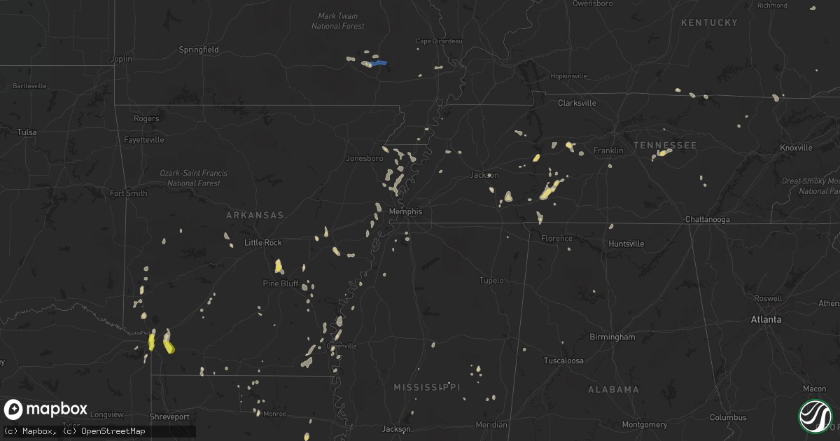
Hail Map in Kentucky on June 26, 2022
Get this storm
June 26 map
$229
one time, instant access
Download today. No call, no setup
Keep the $229
Bought the map and want the full workflow? Apply the entire $229 to a subscription within 7 days. None of it is wasted.
Every map, not just this one
This buys you this map. Subscription and you get every map we run, in the markets you choose from a few cities to whole states to nationwide. Plus real-time alerts the moment a storm fires.
Contact data
Name, contact info, occupancy, even credit band for addresses in the footprint. You go from where it hit to who to call.
Become the source they trust
Unlimited branding weather history reports on demand. You already have the documented answer ready for the property owner, and you are the one who showed up with it.
Property data and RoofTrace estimates
Pull up any address you have got, its value and the exact code rules for that jurisdiction, straight from One Click Code. Then RoofTrace estimates the squares, pitch, and roof value, priced the way you price.
Storm reports in Kentucky
Kentucky
| Date | Description |
|---|---|
| 06/26/20222:45 PM CDT | Downed tree fell onto truck damaging the camper. This occurred on sunset avenue in tompkinsville. |
| 06/26/20221:23 PM CDT | A 3 inch diameter tree limb was blown down along oakwood drive. |
| 06/26/202212:45 PM CDT | Tree down in road on highway 52 west. |
| 06/26/202212:52 AM CDT | At 552 PM EDT, a severe thunderstorm was located over Zion Hill, or 10 miles south of Williamsburg, moving southeast at 10 mph. HAZARD...60 mph wind gusts and quarter size hail. SOURCE...Radar indicated. IMPACT...Hail damage to vehicles is expected. Expect wind damage to roofs, siding, and trees. Locations impacted include... La Follette, Jellico, Elk Valley, Indian Mountain State Park, Clairfield, Fincastle and White Oak.This includes Interstate 75 in Tennessee between mile markers 150 and161. |
| 06/25/20229:23 PM CDT | At 222 PM EDT, severe thunderstorms were located along a line extending from Lee City to Curt to near Cowcreek, moving southeast at 20 mph. HAZARD...60 mph wind gusts. SOURCE...Radar indicated. IMPACT...Expect damage to roofs, siding, and trees. Severe thunderstorms will be near... Haddix around 230 PM EDT. Lost Creek around 235 PM EDT. Watts around 240 PM EDT.Other locations in the path of these severe thunderstorms includeDalesburg, Buckhorn and Rowdy. |
| 06/25/20228:43 PM CDT | At 143 PM EDT, a severe thunderstorm was located over Grannie, or over Campton, moving east at 30 mph. HAZARD...60 mph wind gusts. SOURCE...Radar indicated. IMPACT...Expect damage to roofs, siding, and trees. This severe thunderstorm will be near... Vortex around 150 PM EDT. Lane around 155 PM EDT. Malaga around 200 PM EDT.Other locations in the path of this severe thunderstorm includePaxton and Simpson. |
All States Impacted by Hail Map on June 26, 2022
Cities Impacted by Hail Map on June 26, 2022
- Sherrill, AR
- Louisa, KY
- Dyersburg, TN
- Halls, TN
- Henning, TN
- Ripley, TN
- Camden, TN
- Hestand, KY
- Celina, TN
- Newcomb, TN
- Jellico, TN
- Pine Knot, KY
- Williamsburg, KY
- Smithville, TN
- Woodbury, TN
- Liberty, TN
- Dowelltown, TN
- Dumas, AR
- Nunnelly, TN
- Dickson, TN
- Bon Aqua, TN
- Hernando, MS
- Downsville, LA
- Whitewater, MO
- Manila, AR
- Etowah, AR
- Olivehill, TN
- Savannah, TN
- Lake Village, AR
- Waverly, TN
- McEwen, TN
- Hurricane Mills, TN
- Humphrey, AR
- Widener, AR
- Hughes, AR
- Finger, TN
- Morris Chapel, TN
- Bethel Springs, TN
- Enville, TN
- Adamsville, TN
- Throckmorton, TX
- Burleson, TX
- Clarksdale, MS
- Lockesburg, AR
- Luxora, AR
- Blytheville, AR
- Winnsboro, LA
- Louisville, MS
- Strong, AR
- Mill Spring, MO
- Mineral Wells, TX
- Whitt, TX
- Graford, TX
- Weatherford, TX
- Perrin, TX
- Earle, AR
- Heth, AR
- Allons, TN
- Deer Lodge, TN
- Ridgely, TN
- Arkadelphia, AR
- Lobelville, TN
- Holladay, TN
- Sugar Tree, TN
- Kingsland, AR
- Altheimer, AR
- Stuttgart, AR
- Texarkana, TX
- Texarkana, AR
- Glen, MS
- Graham, TX
- Woodson, TX
- Carthage, MS
- Gilbertown, AL
- Jackson, TN
- Dubach, LA
- Queen City, TX
- Hollow Rock, TN
- Mansfield, TN
- Snow Lake, AR
- Pearl, MS
- Marked Tree, AR
- Lepanto, AR
- Tyronza, AR
- Benton, AR
- Paron, AR
- Gould, AR
- Osceola, AR
- Keiser, AR
- Jeanerette, LA
- Linden, TN
- Jacksboro, TX
- Kimbolton, OH
- Marvell, AR
- Poplar Grove, AR
- Waynesboro, TN
- Piedmont, MO
- Patterson, MO
- Lyles, TN
- Essex, MO
- Ethelsville, AL
- Prescott, AR
- Montrose, AR
- Henderson, TN
- Hohenwald, TN
- Roscoe, TX
- Brush Creek, TN
- Gordonsville, TN
- Flat Lick, KY
- Hayti, MO
- Caruthersville, MO
- Natchez, MS
- Roxie, MS
- Mound Bayou, MS
- Pikeville, TN
- Gurdon, AR
- Logan, AL
- Crane Hill, AL
- Dunlap, TN
- Columbia, TN
- Spring Hill, TN
- Selmer, TN
- Pinson, TN
- Marks, MS
- Clifton, TN
- Mathias, WV
- Lost City, WV
- Readyville, TN
- Tompkinsville, KY
- Gamaliel, KY
- De Queen, AR
- Dermott, AR
- Brickeys, AR
- Forrest City, AR
- Marianna, AR
- Parks, AR
- Abbeville, LA
- Darden, TN
- Lexington, TN
- Marion, LA
- Van Buren, MO
- Ellington, MO
- Rugby, TN
- Robbins, TN
- Greenville, MS
- Northport, AL
- Wellton, AZ
- Warren, AR
- Bassfield, MS
- De Valls Bluff, AR
- Biscoe, AR
- New Iberia, LA
- Broussard, LA
- Youngsville, LA
- Newcastle, TX
- Kaplan, LA
- Lake Charles, LA
- Sumrall, MS
- Albany, LA
- Hammond, LA
- Holden, LA
- Springfield, LA
- Port Allen, LA
- Saint Martinville, LA
- Bluffton, AR
- Monette, AR
- Lake City, AR
- Leighton, AL
- Tucker, AR
- England, AR
- Redfield, AR
- Jefferson, AR
- Emerson, AR
- Albany, TX
- Dell, AR
- Leachville, AR
- Westlake, LA
- Sulphur, LA
- Centerville, TN
- Clarendon, AR
- Cotton Plant, AR
- Brinkley, AR
- Horatio, AR
- De Witt, AR
- Tunica, MS
- Sikeston, MO
- Beattyville, KY
- Rogers, KY
- Campton, KY
- Steele, MO
- Bryson, TX
- Salome, AZ
- Friendship, TN
- Holly Grove, AR
- Umpire, AR
- Mena, AR
- Orange, TX
- Newellton, LA
- Rohwer, AR
- Benoit, MS
- De Kalb, MS
- Garland City, AR
- Fouke, AR
- Colorado City, TX
- Turrell, AR
- Bassett, AR
- Wilson, AR
- Joiner, AR
- Gilmore, AR
- Dyess, AR
- Jonesville, LA
- Iowa, LA
- Parsons, TN
- Branchland, WV
- East Lynn, WV
- Stephenville, TX
- Bluff Dale, TX
- Mendenhall, MS
- Magee, MS
- Kilmichael, MS
- Winona, MS
- Ashdown, AR
- Ovett, MS
- Walker, LA
- El Dorado, AR
- Junction City, AR
- Greenville, MO
- Ogden, AR
- Vidor, TX
- Mize, MS
- Mount Olive, MS
- Bernice, LA
- Farmerville, LA
- Raleigh, MS
- Erath, LA
- Eudora, AR
- Brandon, MS
- McGehee, AR
- Vinegar Bend, AL
- Picayune, MS
- Bay Saint Louis, MS
- Preston, MS
- Tolar, TX
- Lutts, TN
- Hattiesburg, MS
- Portland, AR
- Parkdale, AR
- Hamburg, AR
- Wilton, AR
- Hooks, TX
- Maud, TX
- Athens, AL
- Ardmore, AL
- Elkmont, AL
- Toney, AL
- Gilbert, LA
- Philadelphia, MS
- Waterloo, AL
- Haynesville, LA
- Delcambre, LA
- Calhoun, LA
- Williamsville, MO
- Lewisville, AR
- Fulton, AR
- Jena, LA
- Durant, MS
- Angie, LA
- Paulding, MS
- Canton, MS
- Choudrant, LA
- Delhi, LA
- Pinola, MS
- Spearsville, LA
- Wappapello, MO


