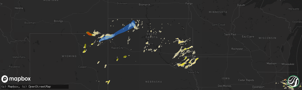
Hail Map in South Dakota on June 26, 2019
The weather event in South Dakota on June 26, 2019 includes Hail and Wind maps. 31 states and 997 cities were impacted and suffered possible damage. The total estimated number of properties impacted is 6,222.
Want more than just the map?
Turn this storm into a full workflow.
- Owner + property data so you know who to knock
- OnDemand branded weather history reports to win the "did we even have hail?" argument
- RoofTrace estimate so reps stop guessing numbers at the door
Bought this map? Upgrade within 7 days and we'll credit the $230. (10-15 min setup call)
Hail
Wind
6,222
Estimated number of impacted properties by a 1.00" hail or larger0
Estimated number of impacted properties by a 1.75" hail or larger0
Estimated number of impacted properties by a 2.50" hail or largerStorm reports in South Dakota
South Dakota
| Date | Description |
|---|---|
| 06/26/20196:35 AM CDT | Tree down... Time estimated from radar. |
| 06/26/20196:23 AM CDT | At 1123 PM MDT, severe thunderstorms were located along a line extending from 4 miles south of Sorum to 3 miles southwest of Mud Butte to 7 miles east of Owl Butte, moving east at 40 mph. HAZARD...60 mph wind gusts and quarter size hail. SOURCE...Radar indicated. IMPACT...Hail damage to vehicles is expected. Expect wind damage to roofs, siding, and trees. Locations impacted include... Faith, Chance, Usta, Maurine, Stoneville, Opal, Mud Butte, Date, Fairpoint, Marcus, Zeona, Red Owl, Durkee Lake and Arrow Head Buttes. |
| 06/26/20195:43 AM CDT | At 1043 PM MDT, severe thunderstorms were located along a line extending from 10 miles southwest of Crow Buttes to 5 miles northeast of Arpan to 4 miles southwest of Fruitdale, moving east at 45 mph. HAZARD...60 mph wind gusts and quarter size hail. SOURCE...Radar indicated. IMPACT...Hail damage to vehicles is expected. Expect wind damage to roofs, siding, and trees. Locations impacted include... Newell, Nisland, Vale, Fruitdale, Castle Rock, Hoover, Arpan, Owl Butte, Haystack Buttes, Newell Lake, Dears Ears Butte, Belle Fourche Reservoir and Two Top Butte. |
| 06/26/20195:05 AM CDT | Received report via twitter... Dime to quarter-sized hail with most of the hail falling as pea to dime-sized. |
| 06/26/20194:15 AM CDT | A mix of penny and quarter sized hail. |
| 06/26/20193:50 AM CDT | . |
| 06/26/20193:31 AM CDT | At 830 PM MDT, a severe thunderstorm was located 4 miles southwest of Rockyford, or 30 miles north of Pine Ridge, moving northeast at 40 mph. HAZARD...60 mph wind gusts and quarter size hail. SOURCE...Radar indicated. IMPACT...Hail damage to vehicles is expected. Expect wind damage to roofs, siding, and trees. Locations impacted include... Rockyford, Sharps Corner and southern Badlands National Park. |
| 06/26/20192:50 AM CDT | At 750 PM MDT, a severe thunderstorm was located 3 miles south of Smithwick, or 16 miles southeast of Hot Springs, moving northeast at 30 mph. HAZARD...60 mph wind gusts and quarter size hail. SOURCE...Radar indicated. IMPACT...Hail damage to vehicles is expected. Expect wind damage to roofs, siding, and trees. Locations impacted include... Oral, Buffalo Gap, Oelrichs, Fairburn, Smithwick, Red Shirt Table Overlook, Hay Canyon Butte, Intersection of Red Shirt and Cuny Table Roads and southeastern Angostura Reservoir. |
| 06/26/20192:18 AM CDT | Occurred with decaying thunderstorms |
| 06/26/20192:00 AM CDT | Power pole yard light knocked down from post thunderstorm outflow wind. Wind estimated to be 60 to 80 mph around 100 am mdt. |
| 06/26/20191:56 AM CDT | Occurred with decaying thunderstorms |
| 06/26/20191:33 AM CDT | Wind gust associated with a heat burst with a collapsing thunderstorm. |
| 06/26/20191:33 AM CDT | Trees down in mission. Appears to be a heat burst with a collasping thunderstorm. |
| 06/26/20191:31 AM CDT | At 631 PM MDT, a severe thunderstorm was located 16 miles south of Redbird, or 18 miles northeast of Lusk, moving north at 30 mph. HAZARD...60 mph wind gusts and half dollar size hail. SOURCE...Radar indicated. IMPACT...Hail damage to vehicles is expected. Expect wind damage to roofs, siding, and trees. Locations impacted include... Redbird. |
| 06/26/20191:30 AM CDT | Heat burst with a decaying thunderstorm. |
| 06/26/20191:24 AM CDT | A local report indicates 66 MPH wind near 7 SSE MEADOW |
| 06/26/20191:23 AM CDT | Convective wind gust along outflow boundry from thunderstorms 30 miles north |
| 06/26/20191:19 AM CDT | A local report indicates 60 MPH wind near 1 WSW RED ELM |
| 06/26/20191:15 AM CDT | Corrects previous tstm wnd gst report from 7 n shambo ranch. Estimated 50-60mph wind... Small branches down. |
| 06/26/20191:10 AM CDT | Estimated 50-60mph wind... Small branches down. |
| 06/26/20191:00 AM CDT | Roof torn off buildings... Huge trees snapped and split. Trailer house damaged. |
| 06/26/201912:55 AM CDT | Convective wind gust along outflow boundary 30 miles from thunderstorms. |
| 06/26/201912:55 AM CDT | Convective wind gusts along outflow boundary 30 miles from thunderstorms. |
| 06/26/201912:55 AM CDT | Convective wind gusts along outflow boundary 30 miles from thunderstorms. |
| 06/26/201912:47 AM CDT | Convective wind gusts along outflow boundary 30 miles from thunderstorms. |
| 06/26/201912:46 AM CDT | Convective wind gusts along outflow boundary 30 miles from thunderstorms. |
| 06/26/201912:44 AM CDT | Convective wind gusts along outflow boundary 30 miles from thunderstorms. |
| 06/26/201912:06 AM CDT | A local report indicates 70 MPH wind near HOOVER |
| 06/25/201911:45 PM CDT | A local report indicates 60 MPH wind near 12 WSW CASTLE ROCK |
| 06/25/201911:45 PM CDT | A local report indicates 60 MPH wind near 1 SSW DOWNTOWN BELLE FO |
| 06/25/201911:10 PM CDT | A local report indicates 60 MPH wind near COLONY |
| 06/25/20199:50 PM CDT | A local report indicates 1.00 inch wind near 1 N ROCKYFORD |
| 06/25/20199:07 PM CDT | A local report indicates 1.00 inch wind near SMITHWICK |
All States Impacted by Hail Map on June 26, 2019
Cities Impacted by Hail Map on June 26, 2019
- Gettysburg, SD
- Huron, SD
- Larchwood, IA
- Portland, TN
- Goodlettsville, TN
- Cottontown, TN
- Hendersonville, TN
- Cross Plains, TN
- Greenbrier, TN
- White House, TN
- Gillette, WY
- Murfreesboro, TN
- Plainfield, IL
- Minooka, IL
- Joliet, IL
- Crossville, IL
- Grayville, IL
- Mulkeytown, IL
- Royalton, IL
- Huntingdon, TN
- Trezevant, TN
- Atwood, TN
- Lexington, AL
- Condon, OR
- Moorcroft, WY
- Island Park, ID
- Vandalia, IL
- Greenville, IL
- Keyesport, IL
- Alma, IL
- Mulberry Grove, IL
- Smithboro, IL
- Kinmundy, IL
- Vernon, IL
- Patoka, IL
- Shobonier, IL
- Saint Louis, MO
- Florissant, MO
- Huntsville, AR
- Witter, AR
- Franklin, GA
- Olney, IL
- Hurley, SD
- Viborg, SD
- Lennox, SD
- Davis, SD
- New Canton, IL
- Pleasant Hill, IL
- Barry, IL
- Rockport, IL
- Elizabeth, AR
- Charleston, MO
- Decker, MT
- Otter, MT
- Jackson, MO
- Tuttle, ND
- Wing, ND
- Biggers, AR
- Bowling Green, KY
- Lock Haven, PA
- Francesville, IN
- Dupree, SD
- Broadus, MT
- Hulett, WY
- Weston, WY
- Alzada, MT
- Willsboro, NY
- Essex, NY
- Lyman, NE
- Warrenton, MO
- Fredericktown, MO
- Perryville, MO
- Sainte Genevieve, MO
- Farmington, MO
- Saint Mary, MO
- Chester, IL
- Slaughters, KY
- Sebree, KY
- Lewiston, ID
- Anatone, WA
- Asotin, WA
- Eddyville, KY
- Darby, MT
- Lodge Grass, MT
- Festus, MO
- Bloomsdale, MO
- Poplar Bluff, MO
- Frankfort, IL
- University Park, IL
- Richton Park, IL
- Monee, IL
- Homewood, IL
- Thornton, IL
- Saint John, IN
- Lansing, IL
- Olympia Fields, IL
- Dyer, IN
- Tinley Park, IL
- Chicago Heights, IL
- Crete, IL
- Glenwood, IL
- Park Forest, IL
- Matteson, IL
- Steger, IL
- Green Forest, AR
- Berryville, AR
- Hanover, KS
- Frazer, MT
- Rensselaer, IN
- Fair Oaks, IN
- Cape Girardeau, MO
- Colman, SD
- Hamilton, MT
- Stockett, MT
- Great Falls, MT
- Cascade, MT
- Wolf Creek, MT
- Canyon Creek, MT
- Rozet, WY
- Medaryville, IN
- Poplar, MT
- Wolf Point, MT
- Scobey, MT
- Philpot, KY
- Flandreau, SD
- Elkton, SD
- Vermillion, SD
- Williamsfield, IL
- Princeville, IL
- Toulon, IL
- Speer, IL
- La Fayette, IL
- Galva, IL
- Victoria, IL
- Laura, IL
- Brimfield, IL
- Altona, IL
- Saint Jacob, IL
- Bloomfield, MO
- Advance, MO
- Puxico, MO
- Kaycee, WY
- Buffalo, WY
- Luverne, MN
- Jasper, MN
- Garretson, SD
- Hardwick, MN
- Mountain Home, AR
- Hot Springs, SD
- Prairie City, SD
- Washington, MO
- Pilot Knob, MO
- Arcadia, MO
- Lesterville, MO
- Annapolis, MO
- Ironton, MO
- Middle Brook, MO
- Minneota, MN
- Taunton, MN
- Porter, MN
- Canby, MN
- Meadow, SD
- Demotte, IN
- Madison, SD
- Lusk, WY
- Vergennes, IL
- Du Quoin, IL
- Elkville, IL
- Rockvale, TN
- Birney, MT
- Alexandria, SD
- Dundee, KY
- Hartford, KY
- Fordsville, KY
- Olaton, KY
- Water Valley, KY
- Union City, TN
- Martin, TN
- Fulton, KY
- Wingo, KY
- South Fulton, TN
- Valparaiso, IN
- Eagleville, TN
- Dwight, IL
- Gardner, IL
- George, IA
- Doon, IA
- Thomaston, GA
- Milnor, ND
- Cayuga, ND
- Pickrell, NE
- Cortland, NE
- Lebanon, TN
- Xenia, IL
- Johnsonville, IL
- Topeka, IN
- Millersburg, IN
- Shipshewana, IN
- Clearwater, NE
- Oakdale, NE
- Grafton, IL
- Portage Des Sioux, MO
- Woodburn, KY
- Auburn, KY
- Russellville, KY
- Franklin, KY
- Adairville, KY
- Hemphill, TX
- Elgin, IL
- Roselle, IL
- Saint Charles, IL
- Bartlett, IL
- Streamwood, IL
- Hanover Park, IL
- Wayne, IL
- Schaumburg, IL
- Colfax, ND
- Aberdeen, SD
- Westport, SD
- Dyersburg, TN
- Ripley, TN
- Friendship, TN
- Halls, TN
- Wentworth, SD
- Lake Preston, SD
- Erwin, SD
- Plymouth, NE
- New Haven, MO
- Potosi, MO
- Sullivan, MO
- Elkton, KY
- Iroquois, SD
- De Smet, SD
- Bryant, SD
- New Lenox, IL
- Mokena, IL
- Hammond, MT
- Boyes, MT
- Marion, KY
- Culdesac, ID
- Lenore, ID
- Ashwood, OR
- Estelline, SD
- Mission Hill, SD
- Yankton, SD
- Lesterville, SD
- Tabor, SD
- Irene, SD
- Utica, SD
- Volin, SD
- Alcester, SD
- Hawarden, IA
- Hudson, SD
- Murdo, SD
- Draper, SD
- Springfield, MO
- Willard, MO
- Bois D Arc, MO
- Smithwick, SD
- Oral, SD
- Lobelville, TN
- Effie, LA
- East Saint Louis, IL
- Miller City, IL
- Mounds, IL
- Sikeston, MO
- New Madrid, MO
- Matthews, MO
- East Prairie, MO
- Bertrand, MO
- Cairo, IL
- Mitchell, NE
- Yoder, WY
- Morrill, NE
- Howard, SD
- Canova, SD
- Belle Fourche, SD
- Noble, IL
- Henning, TN
- Ireton, IA
- Rock Valley, IA
- Sioux Center, IA
- Rock Rapids, IA
- Elk Point, SD
- Hull, IA
- McIntosh, SD
- Keldron, SD
- Alva, WY
- Willow Lake, SD
- Hoven, SD
- Madison, TN
- Nashville, TN
- Old Hickory, TN
- Aurora, IL
- Wright City, MO
- East Carondelet, IL
- Fenton, MO
- Exeter, MO
- Cassville, MO
- Tyndall, SD
- Scotland, SD
- Wakonda, SD
- Centerville, SD
- Genesee, ID
- Albion, NE
- Mcminnville, TN
- Collinsville, AL
- Alvaton, KY
- Fulton, SD
- Collinsville, IL
- Troy, IL
- O'Fallon, IL
- Pocahontas, AR
- Maynard, AR
- Sedan, NM
- Santa Rosa, NM
- Locke, NY
- Moravia, NY
- Mandan, ND
- Yorkville, IL
- Portageville, MO
- Sugar Grove, IL
- Ethan, SD
- Mooreton, ND
- Hinsdale, IL
- Oak Brook, IL
- Westmont, IL
- Clarendon Hills, IL
- Benton, MO
- Scott City, MO
- Saint Anne, IL
- Pembroke Township, IL
- The Rock, GA
- Colton, SD
- Dell Rapids, SD
- Baltic, SD
- Maple Park, IL
- Romeoville, IL
- Oswego, IL
- Bolingbrook, IL
- Elburn, IL
- Naperville, IL
- Montgomery, IL
- North Aurora, IL
- Quinter, KS
- Gove, KS
- Ozone, AR
- Faulkton, SD
- Onaka, SD
- Seneca, SD
- Wana, WV
- Holbrook, PA
- Aleppo, PA
- New Freeport, PA
- Williamsville, MO
- Horse Branch, KY
- Cromwell, KY
- Beaver Dam, KY
- Whitesville, KY
- Utica, KY
- Owensboro, KY
- Lewisport, KY
- Maceo, KY
- Boyd, MN
- Enderlin, ND
- Gallatin, TN
- Shreveport, LA
- Harrison, AR
- Compton, AR
- Alpena, AR
- Kennebec, SD
- Keithville, LA
- Dudley, MO
- Cherokee Village, AR
- Hardy, AR
- New Haven, IN
- Monroeville, IN
- Woodburn, IN
- Cottonwood, MN
- Peotone, IL
- Beecher, IL
- Sycamore, PA
- West Finley, PA
- Graysville, PA
- Waynesburg, PA
- Douglas, WY
- Lance Creek, WY
- Shawnee, WY
- Arnold, MO
- House, NM
- Elsberry, MO
- Watauga, SD
- Holcomb, MO
- Piggott, AR
- Greenway, AR
- Rector, AR
- Taft, TN
- Grant Park, IL
- Momence, IL
- Campbell Hill, IL
- Pinckneyville, IL
- Cutler, IL
- Ava, IL
- Roosevelt, WA
- Goldendale, WA
- Franklin, AR
- Kendrick, ID
- Lisbon, ND
- Vidalia, LA
- Sundance, WY
- Volga, SD
- Arlington, SD
- Garrison, MT
- Alton, MO
- Doniphan, MO
- Fremont, MO
- Ravenden, AR
- Canistota, SD
- Salem, SD
- Gassville, AR
- Center Sandwich, NH
- Moultonborough, NH
- Government Camp, OR
- Welches, OR
- Rhododendron, OR
- Lapwai, ID
- Linton, ND
- Leslie, MO
- Beaufort, MO
- Greenville, KY
- Holland, MN
- Ruthton, MN
- Goshen, IN
- Ligonier, IN
- Middlebury, IN
- Truesdale, MO
- Thayer, MO
- Drakesboro, KY
- Eolia, MO
- Silex, MO
- Beresford, SD
- Canton, SD
- Parker, SD
- Rockfield, KY
- Schroon Lake, NY
- Goodland, IN
- Remington, IN
- Jasper, TX
- Newton, TX
- Troy, NY
- Cropseyville, NY
- Hobson, MT
- Wessington, SD
- Bragg City, MO
- Steele, MO
- Hayti, MO
- Caruthersville, MO
- Gold Creek, MT
- Ione, OR
- Boardman, OR
- North Liberty, IN
- Parma, MO
- Catron, MO
- Kadoka, SD
- Clarks, NE
- Stromsburg, NE
- Koshkonong, MO
- Labelle, FL
- Mitchell, SD
- Highmore, SD
- Kountze, TX
- Willowbrook, IL
- Lemont, IL
- Willow Springs, IL
- Salem, KY
- Trent, SD
- Wolcott, IN
- Monon, IN
- Fairview, WV
- Marthasville, MO
- Doe Run, MO
- Naylor, MO
- Oxly, MO
- Pollard, AR
- Torrington, WY
- Benedict, NE
- Florien, LA
- Richwoods, MO
- Coushatta, LA
- Webster, SD
- Hindsville, AR
- Howes, SD
- Spencer, SD
- Claremont, IL
- Belleview, MO
- Caledonia, MO
- Belgrade, MO
- Dimock, SD
- Troy, MO
- Dieterich, IL
- Mason, IL
- Louisville, IL
- Moore, MT
- Wall, SD
- Christiana, TN
- McKenzie, TN
- Aladdin, WY
- Worthing, SD
- Clarkston, WA
- Gann Valley, SD
- French Village, MO
- Bonne Terre, MO
- Morgantown, KY
- Silsbee, TX
- Lumberton, TX
- Bison, SD
- Cedar Lake, IN
- Wanatah, IN
- Westville, IN
- Greenville, MO
- Isabel, SD
- Edwardsville, IL
- Kingston, AR
- Marble Falls, AR
- Madison, MN
- Montrose, SD
- Clarksville, MO
- Dawson, ND
- La Porte, IN
- Union Mills, IN
- Park Hills, MO
- Presho, SD
- Vivian, SD
- Gayville, SD
- Fordyce, NE
- Saint Helena, NE
- Reynolds, IN
- Patterson, MO
- Piedmont, MO
- Lake Norden, SD
- Badger, SD
- Ellendale, ND
- Forbes, ND
- Jerseyville, IL
- Kenton, TN
- Mount Juliet, TN
- Naples, FL
- Fredonia, KY
- Barney, ND
- Wyndmere, ND
- Clearwater, FL
- Sutton, NE
- Ravenden Springs, AR
- Warm Springs, AR
- Bernie, MO
- Cave In Rock, IL
- Jonesburg, MO
- Pocahontas, IL
- Inwood, IA
- Imperial, MO
- Barnhart, MO
- McLaughlin, SD
- Cazenovia, NY
- Imboden, AR
- Winfred, SD
- Darien, IL
- Woodridge, IL
- Palos Park, IL
- Downers Grove, IL
- Evans, LA
- Killen, AL
- Florence, AL
- Lewisburg, KY
- Central City, KY
- Hopkinsville, KY
- Beech Creek, KY
- Sikes, LA
- Winnfield, LA
- Olla, LA
- Fort Pierre, SD
- Woodland, AL
- Gering, NE
- Fossil, OR
- Palco, KS
- Woodstock, MN
- Morocco, IN
- Lake Village, IN
- Ree Heights, SD
- Mazon, IL
- Oak Ridge, MO
- Pembroke, KY
- Trenton, KY
- Dresden, TN
- Sharon, TN
- Chancellor, SD
- Hartford, SD
- Golden Gate, IL
- Mount Erie, IL
- Ellery, IL
- Fairfield, IL
- Cisne, IL
- Springdale, AR
- Fayetteville, AR
- Decatur, AL
- Danville, AL
- Marston, MO
- Selby, SD
- Pipestone, MN
- Bloomingdale, IL
- Medinah, IL
- Itasca, IL
- Addison, IL
- Flat Rock, IL
- Highland, IL
- Ewing, NE
- Miller, SD
- New Douglas, IL
- Alhambra, IL
- Henderson, TN
- Faith, SD
- Erie, MI
- Geff, IL
- Sims, IL
- Kyle, SD
- Pine Ridge, SD
- Lawrenceville, IL
- Reynolds Station, KY
- Bethpage, TN
- Horseshoe Bend, AR
- Punta Gorda, FL
- Nunnelly, TN
- Lebanon, SD
- Fairbury, NE
- Jansen, NE
- Yellville, AR
- Summit, AR
- Olivet, SD
- Parkston, SD
- Emery, SD
- Roopville, GA
- Wakeeney, KS
- Yatesville, GA
- Marion, MT
- Monett, MO
- Pierce City, MO
- Purdy, MO
- Ludlow, SD
- Indiantown, FL
- Port Charlotte, FL
- Philipsburg, MT
- Wolcottville, IN
- Lascassas, TN
- Buffalo, SD
- Carpenter, SD
- Paw Paw, IL
- Lee, IL
- Shabbona, IL
- Steward, IL
- Harvey, IL
- Hazel Crest, IL
- Markham, IL
- Yeso, NM
- Broseley, MO
- Odell, NE
- Wymore, NE
- Avon, SD
- Niobrara, NE
- Louisiana, MO
- Calhoun, IL
- Parkersburg, IL
- Mascoutah, IL
- Sardis, TN
- Placida, FL
- Stonewall, LA
- Tappen, ND
- Pettibone, ND
- Mammoth Spring, AR
- Camp, AR
- Upton, WY
- Prosser, WA
- Bridgewater, SD
- Hall, MT
- Steen, MN
- Bourbon, MO
- Whitewater, MO
- Charlotte, VT
- Shelburne, VT
- Harviell, MO
- Homer Glen, IL
- Pittsfield, IL
- Gobler, MO
- Waubay, SD
- Chambersburg, IL
- Ingraham, IL
- Clayton, NM
- Chester, SD
- Lockport, IL
- Prairie Du Rocher, IL
- Red Bud, IL
- Evansville, IL
- Ellis Grove, IL
- Modoc, IL
- Bruceton, TN
- Buena Vista, TN
- Hartington, NE
- Wynot, NE
- Rosine, KY
- Hampton, KY
- Beaver Creek, MN
- Albers, IL
- Deerfield, MO
- Winamac, IN
- Valley Springs, AR
- Alamo, TN
- Centerville, TN
- Linden, TN
- Enville, TN
- Black Rock, AR
- Wind Ridge, PA
- West Alexander, PA
- Triadelphia, WV
- Dallas, WV
- Farina, IL
- Saint Peter, IL
- Channahon, IL
- Houston, TX
- Spraggs, PA
- Campbell, MO
- Malden, MO
- Clarkton, MO
- Gideon, MO
- Chambers, NE
- Carmi, IL
- Falls Of Rough, KY
- Shelby, NE
- Grandin, MO
- Texline, TX
- Caseyville, IL
- Flippin, AR
- Gleason, TN
- Brooks, GA
- Roscoe, SD
- Ash Grove, MO
- Everton, MO
- Walnut Grove, MO
- Rising City, NE
- Humboldt, SD
- Clinton, KY
- Lawrenceburg, TN
- Elgin, NE
- Williford, AR
- Cannon Ball, ND
- Martell, NE
- Hallam, NE
- Langford, SD
- Menno, SD
- Burnt Prairie, IL
- Tamms, IL
- Granite Falls, MN
- Antelope, OR
- Randolph, NE
- Mclean, NE
- Hope, NM
- Lake Wilson, MN
- Balaton, MN
- Valley Falls, NY
- Johnsonville, NY
- Columbus, KS
- Scammon, KS
- Cherokee, KS
- Weir, KS
- Pulaski, IL
- Olmsted, IL
- Dongola, IL
- Ullin, IL
- Gilmer, TX
- Clubb, MO
- Lowndes, MO
- Washburn, MO
- Fort Thompson, SD
- Ash Flat, AR
- Oakes, ND
- Alexander, IL
- New Berlin, IL
- Brookeland, TX
- Peck, ID
- Reubens, ID
- Devils Tower, WY
- Yale, SD
- Flora, IL
- Clay City, IL
- Marksville, LA
- Deville, LA
- Glenham, SD
- Corsica, SD
- Armour, SD
- Rumsey, KY
- Lowell, IN
- Hebron, IN
- Shell Knob, MO
- Bruce, SD
- Worden, IL
- Scottsville, KY
- Eagle Butte, SD
- Munnsville, NY
- Oneida, NY
- Shaniko, OR
- Hills, MN
- Johnstown, NE
- Kathryn, ND
- Fort Ransom, ND
- Odin, IL
- Salem, IL
- West Frankfort, IL
- Fisk, MO
- Dexter, MO
- Orland Park, IL
- Palos Heights, IL
- Litchfield, IL
- Fort Payne, AL
- Immokalee, FL
- Clearmont, WY
- High Ridge, MO
- Eureka, MO
- Millstadt, IL
- Ballwin, MO
- Wildwood, MO
- Maryville, IL
- Valley Park, MO
- Lebanon, IL
- Belleville, IL
- Granite City, IL
- Dupo, IL
- Chesterfield, MO
- Columbia, IL
- Bismarck, MO
- Bonita Springs, FL
- Saint Lawrence, SD
- Kouts, IN
- Belton, KY
- Dunmor, KY
- Burbank, SD
- Dittmer, MO
- De Soto, MO
- Fletcher, MO
- Hillsboro, MO
- Pettigrew, AR
- Kentland, IN
- Brook, IN
- Anderson, AL
- Petersburg, NY
- Averill Park, NY
- Vincennes, IN
- Java, SD
- Battletown, KY
- Van Buren, MO
- Lafe, AR
- Trinity, AL
- Cooter, MO
- Toronto, SD
- Brussels, IL
- Batchtown, IL
- Lead Hill, AR
- Burfordville, MO
- Spearfish, SD
- Crown Point, IN
- Thayer, IN
- Wheatfield, IN
- Schneider, IN
- South Holland, IL
- Bourbonnais, IL
- Munster, IN
- Shelby, IN
- Schererville, IN
- Kankakee, IL
- Highland, IN
- Hammond, IN
- Gerald, MO
- Newcastle, NE
- Little Rock, IA
- Palm Harbor, FL
- Alvord, IA
- Golden City, MO
- Clear Lake, SD
- Kinderhook, IL
- Timber Lake, SD
- Glencoe, AR
- Taiban, NM
- Bismarck, ND
- Cape Coral, FL
- Waterman, IL
- Selfridge, ND
- Oshkosh, NE
- Surprise, NE
- Locust Gap, PA
- Hegins, PA
- Springfield, TN
- Irondale, MO
- Ochopee, FL
- Litchville, ND
- West Alton, MO
- Everton, AR
- Garland, KS
- Fort Sumner, NM
- Braidwood, IL
- Bridgeport, NE
- Nokomis, IL
- Barneston, NE
- Newman Grove, NE
- Marquand, MO
- Browder, KY
- Tripp, SD
- Rives, TN
- Mayfield, KY
- Findlay, OH
- Alvada, OH
- Ramona, SD
- Mechanicville, NY
- Clifton Park, NY
- Lampe, MO
- Marthaville, LA
- Calico Rock, AR
- Cotter, AR
- Viola, AR
- Wappapello, MO
- Encinal, TX
- Staplehurst, NE
- Seward, NE
- York, NE
- Westmoreland, TN
- Fyffe, AL
- Elwood, IL
- West Chicago, IL
- Hermitage, TN
- Wolsey, SD
- Dalhart, TX
- Okeechobee, FL
- Dadeville, MO
- Adolphus, KY
- Bickleton, WA
- Hardinsburg, KY
- Pleasant Plains, IL
- Cantrall, IL
- Freeman, SD
- Gary, IN
- East Chicago, IN
- Dundas, IL
- Sturkie, AR
- Salem, AR
- Town Creek, AL
- Russellville, AL
- Pierre, SD
- Kirbyville, TX
- Jacks Creek, TN
- Valley Springs, SD
- Tuthill, SD
- Natchitoches, LA
- Woodville, MS
- Natchez, MS
- Callicoon, NY
- Spurger, TX
- Mansfield, LA
- Boca Grande, FL
- New Leipzig, ND
- Marion, SD
- Cypress, IL
- Damascus, PA
- Nebo, IL
- Brownstown, IL
- Gibson, MO
- Qulin, MO
- Camden, TN
- Hanson, KY
- Agar, SD
- Buffalo Gap, SD
- Wheatland, WY
- Greenfield, TN
- Hawk Point, MO
- Vulcan, MO
- Onida, SD
- Wagner, SD
- Marble Hill, MO
- Coleridge, NE
- Edgewood, IL
- Provencal, LA
- Monticello, IN
- Mcleod, ND
- Crown Point, NY
- Volborg, MT
- Powderville, MT
- Recluse, WY
- Galena, KS
- Pittsburg, KS
- Mud Butte, SD
- Newell, SD
- Beulah, WY
- Morristown, SD


