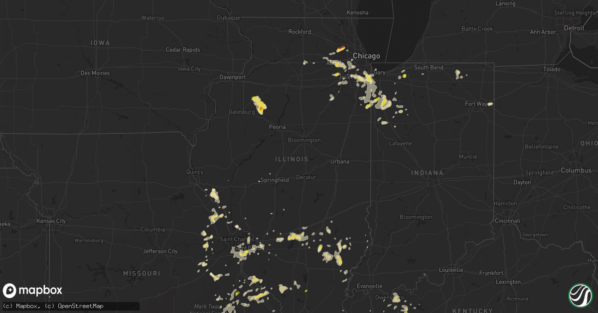
Hail Map in Illinois on June 26, 2019
Get this storm
June 26 map
$229
one time, instant access
Download today. No call, no setup
Keep the $229
Bought the map and want the full workflow? Apply the entire $229 to a subscription within 7 days. None of it is wasted.
Every map, not just this one
This buys you this map. Subscription and you get every map we run, in the markets you choose from a few cities to whole states to nationwide. Plus real-time alerts the moment a storm fires.
Contact data
Name, contact info, occupancy, even credit band for addresses in the footprint. You go from where it hit to who to call.
Become the source they trust
Unlimited branding weather history reports on demand. You already have the documented answer ready for the property owner, and you are the one who showed up with it.
Property data and RoofTrace estimates
Pull up any address you have got, its value and the exact code rules for that jurisdiction, straight from One Click Code. Then RoofTrace estimates the squares, pitch, and roof value, priced the way you price.
Storm reports in Illinois
Illinois
| Date | Description |
|---|---|
| 06/26/20196:44 PM CDT | Penny to quarter hail. |
| 06/26/20196:05 PM CDT | A local report indicates 1.00 inch wind near XENIA |
| 06/26/20196:00 PM CDT | A local report indicates 1.00 inch wind near WEST FRANKFORT |
| 06/26/20195:55 PM CDT | Corrects previous tstm wnd dmg report from 2 s dongola. Disregard report. Damage occurred on i-57 at mile marker 20 in missouri. |
| 06/26/20195:25 PM CDT | A local report indicates 1.00 inch wind near 1 ESE DU QUOIN |
| 06/26/20194:25 PM CDT | Tree down of unknown size. |
| 06/26/20194:20 PM CDT | Tree down across marine road roughly one half mile north of st. Jacob. Time estimated from radar. |
| 06/26/20194:00 PM CDT | Multiple tree limbs down near horseshoe lake in granite city. Tree limbs were around 4 inches in diameter. Location approximate. Time estimated from radar. |
| 06/26/20193:35 AM CDT | At 835 PM CDT, a severe thunderstorm was located near Shorewood, or near southwest Plainfield, moving east at 10 mph. HAZARD...60 mph wind gusts and quarter size hail. SOURCE...Radar indicated. IMPACT...Hail damage to vehicles is expected. Expect wind damage to roofs, siding, and trees. Locations impacted include... Joliet, Romeoville, Plainfield, Shorewood, Rockdale, Crest Hill and Crystal Lawns.Including the following interstates... I-55 between mile markers 252 and 259. I-80 between mile markers 129 and 130.This includes... Joliet Junior College. |
| 06/26/20192:48 AM CDT | At 747 PM CDT, a severe thunderstorm was located over Elmore, or 17 miles south of Kewanee, moving south at 10 mph. HAZARD...60 mph wind gusts and quarter size hail. SOURCE...Radar indicated. IMPACT...Hail damage to vehicles is expected. Expect wind damage to roofs, siding, and trees. Locations impacted include... Brimfield, Williamsfield, West Jersey, Laura, Elmore and Monica. This includes Interstate 74 between mile markers 64 and 75. |
| 06/26/20192:34 AM CDT | At 734 PM CDT, a severe thunderstorm was located over Naperville, moving east at 25 mph. HAZARD...60 mph wind gusts and quarter size hail. SOURCE...Radar indicated. IMPACT...Hail damage to vehicles is expected. Expect wind damage to roofs, siding, and trees. Locations impacted include... Aurora, Naperville, Bolingbrook, Downers Grove, Romeoville, Plainfield, Westmont, Lisle, Hinsdale, Lemont, Burr Ridge, Willow Springs, Woodridge, Darien, Warrenville, Countryside, Indian Head Park, Hodgkins and Willowbrook.Including the following interstates... I-55 between mile markers 263 and 278. I-88 between mile markers 121 and 125. I-355 between mile markers 8 and 18.This includes... Argonne National Laboratory, BenedictineUniversity, and North Central College. |
| 06/26/20192:30 AM CDT | At 730 PM CDT, a severe thunderstorm was located over Streamwood, or near Schaumburg, moving east at 20 mph. HAZARD...60 mph wind gusts and quarter size hail. SOURCE...Radar indicated. IMPACT...Hail damage to vehicles is expected. Expect wind damage to roofs, siding, and trees. Locations impacted include... Arlington Heights, Schaumburg, Des Plaines, Mount Prospect, Hoffman Estates, Rolling Meadows, Roselle, Bartlett, Streamwood, Hanover Park, Elk Grove Village, Bensenville, Prospect Heights, Wood Dale, Itasca and Medinah.Including the following interstate... I-290 between mile markers 1 and 5. This includes... Schaumburg Boomers Baseball. |
| 06/26/20192:03 AM CDT | At 703 PM CDT, a severe thunderstorm was located near West Jersey, or 15 miles south of Kewanee, moving east at 10 mph. HAZARD...60 mph wind gusts and half dollar size hail. SOURCE...Radar indicated. IMPACT...Hail damage to vehicles is expected. Expect wind damage to roofs, siding, and trees. Locations impacted include... Princeville, Wyoming, Toulon, West Jersey, Castleton, Duncan and Monica. |
| 06/26/20191:46 AM CDT | At 644 PM CDT, an outflow boundary ahead of approaching thunderstorms is producing winds up to 60 mph. This boundary extended from 9 miles north of Rosiclare to near Barkley Regional Airport, moving east at 50 mph. HAZARD...60 mph wind gusts. SOURCE...Radar indicated. IMPACT...Expect damage to roofs, siding, and trees. Severe thunderstorms will be near... Reidland around 700 PM CDT. Ledbetter around 705 PM CDT. Burna around 715 PM CDT.Other locations impacted by these severe thunderstorms includeCarrsville, Smithland and Hamletsburg. |
| 06/26/20191:42 AM CDT | At 642 PM CDT, a severe thunderstorm was located over Altona, or 11 miles south of Cambridge, moving east at 10 mph. HAZARD...60 mph wind gusts and quarter size hail. SOURCE...Radar indicated. IMPACT...Hail damage to vehicles is expected. Expect wind damage to roofs, siding, and trees. Locations impacted include... Oneida, Altona and Victoria. |
| 06/26/20191:31 AM CDT | At 630 PM CDT, a severe thunderstorm was located near Bishop Hill and Galva, or 8 miles southeast of Cambridge, moving east at 10 mph. HAZARD...60 mph wind gusts and quarter size hail. SOURCE...Radar indicated. IMPACT...Hail damage to vehicles is expected. Expect wind damage to roofs, siding, and trees. Locations impacted include... Kewanee, Galva, Bishop Hill, Nekoma, Kewanee Municipal Airport, Ulah and German Corner. |
| 06/26/20191:16 AM CDT | At 616 PM CDT, severe thunderstorms were located along a line extending from near Xenia to near Fairfield, moving northeast at 10 mph. HAZARD...60 mph wind gusts and half dollar size hail. SOURCE...Radar indicated. IMPACT...Hail damage to vehicles is expected. Expect wind damage to roofs, siding, and trees. Locations impacted include... Fairfield, Cisne, Jeffersonville, Mount Erie and Johnsonville. |
| 06/26/20191:08 AM CDT | At 608 PM CDT, a severe thunderstorm was located near Dundas, or near Olney, moving northeast at 10 mph. HAZARD...60 mph wind gusts and quarter size hail. SOURCE...Radar indicated. IMPACT...Hail damage to vehicles is expected. Expect wind damage to roofs, siding, and trees. Locations impacted include... Ste. Marie, Willow Hill, Claremont, Chauncey, Dundas, Hardinville and West Liberty. |
| 06/26/20191:02 AM CDT | At 602 PM CDT, a severe thunderstorm was located over Xenia, or 8 miles west of Flora, moving north at 10 mph. HAZARD...60 mph wind gusts and quarter size hail. SOURCE...Radar indicated. IMPACT...Hail damage to vehicles is expected. Expect wind damage to roofs, siding, and trees. Locations impacted include... Flora, Xenia and Oskaloosa. |
| 06/26/201912:58 AM CDT | At 558 PM CDT, a severe thunderstorm was located over La Fayette, or 9 miles southwest of Kewanee, moving east at 10 mph. HAZARD...60 mph wind gusts and quarter size hail. SOURCE...Radar indicated. IMPACT...Hail damage to vehicles is expected. Expect wind damage to roofs, siding, and trees. Locations impacted include... Wyoming, Toulon, Elmira, West Jersey, La Fayette and Duncan. |
| 06/26/201912:39 AM CDT | At 538 PM CDT, a severe thunderstorm was located near Noble, or near Olney, moving northeast at 15 mph. HAZARD...60 mph wind gusts and quarter size hail. SOURCE...Radar indicated. IMPACT...Hail damage to vehicles is expected. Expect wind damage to roofs, siding, and trees. Locations impacted include... Olney, Noble, Claremont, Calhoun and Olney Noble Airport. |
| 06/26/201912:31 AM CDT | At 531 PM CDT, a severe thunderstorm was located over Xenia, or 10 miles southwest of Flora, moving north at 15 mph. HAZARD...60 mph wind gusts and quarter size hail. SOURCE...Radar indicated. IMPACT...Hail damage to vehicles is expected. Expect wind damage to roofs, siding, and trees. Locations impacted include... Flora, Louisville, Xenia and Oskaloosa. |
| 06/26/201912:10 AM CDT | At 509 PM CDT, severe thunderstorms were located along a line extending from Pinckneyville to near Ava, moving east at 10 mph. HAZARD...60 mph wind gusts and quarter size hail. SOURCE...Radar indicated. IMPACT...Hail damage to vehicles is expected. Expect wind damage to roofs, siding, and trees. Locations impacted include... Murphysboro, Du Quoin, De Soto, Elkville, Dowell, Vergennes and St. Johns. |
| 06/25/20199:53 PM CDT | At 253 PM CDT, severe thunderstorms were located along a line extending from 6 miles southwest of Red Bud to near Ste. Genevieve, moving northeast at 20 mph. HAZARD...60 mph wind gusts and quarter size hail. SOURCE...Radar indicated. IMPACT...Hail damage to vehicles is expected. Expect wind damage to roofs, siding, and trees. Locations impacted include... Chester, Ste. Genevieve, Red Bud, New Athens, Evansville, Baldwin, Preston, Prairie Du Rocher, Prairie, Lenzburg, Fayetteville, Ellis Grove, Ruma, Kaskaskia, Walsh, Renault, Kellogg, Ames, Roots and Modoc.This includes Interstate 55 in Missouri near exit 150. This also includes Felix Valle House State Park. |
| 06/25/20199:19 PM CDT | At 218 PM CDT, a severe thunderstorm was located near Pleasant Hill, moving east at 20 mph. HAZARD...60 mph wind gusts and quarter size hail. SOURCE...Radar indicated. IMPACT...Hail damage to vehicles is expected. Expect wind damage to roofs, siding, and trees. Locations impacted include... Pleasant Hill, Independence, Bedford, Patterson, Montezuma, Martinsburg, Nebo, Kampsville, Milton, Eldred, Hillview, Pearl, Time, Haypress, New Hartford, Summer Hill and Beecreek. |
| 06/25/20199:10 PM CDT | At 209 PM CDT, a severe thunderstorm was located near Rocky Ridge, moving northeast at 25 mph. HAZARD...60 mph wind gusts and quarter size hail. SOURCE...Trained weather spotters. IMPACT...Hail damage to vehicles is expected. Expect wind damage to roofs, siding, and trees. Locations impacted include... Ste. Genevieve, Bloomsdale, Rocky Ridge, Weingarten, Prairie Du Rocher, Renault, Kellogg, Ames, Roots, Modoc, French Village and Kidd.This includes Interstate 55 in Missouri between exits 150 and 162. This also includes Felix Valle House State Park. |
| 06/25/20199:00 PM CDT | Matteson reports via social media cleanup of numerous damaged trees and branches due to storms. Time estimated by radar. Delayed report. |
| 06/25/20198:42 PM CDT | Social media report of quarter size hail at caton farm rd. And county line rd. |
| 06/25/20197:45 PM CDT | **delayed report** report of several trees and limbs snapped from wednesday evenings storms. Time estimated based on radar. |
| 06/25/20197:38 PM CDT | A local report indicates 2.00 inch wind near STREAMWOOD |
| 06/25/20197:36 PM CDT | A local report indicates 1.00 inch wind near 2 NE HANOVER PARK |
| 06/25/20197:35 PM CDT | A local report indicates 1.50 inch wind near 2 NE HANOVER PARK |
| 06/25/20197:34 PM CDT | Relayed by wmbd-tv |
| 06/25/20197:30 PM CDT | Social media report of pea to quarter size hail near intersection of rt. 34 and eola rd. |
All States Impacted by Hail Map on June 26, 2019
Cities Impacted by Hail Map on June 26, 2019
- Gettysburg, SD
- Huron, SD
- Larchwood, IA
- Portland, TN
- Goodlettsville, TN
- Cottontown, TN
- Hendersonville, TN
- Cross Plains, TN
- Greenbrier, TN
- White House, TN
- Gillette, WY
- Murfreesboro, TN
- Plainfield, IL
- Minooka, IL
- Joliet, IL
- Crossville, IL
- Grayville, IL
- Mulkeytown, IL
- Royalton, IL
- Huntingdon, TN
- Trezevant, TN
- Atwood, TN
- Lexington, AL
- Condon, OR
- Moorcroft, WY
- Island Park, ID
- Vandalia, IL
- Greenville, IL
- Keyesport, IL
- Alma, IL
- Mulberry Grove, IL
- Smithboro, IL
- Kinmundy, IL
- Vernon, IL
- Patoka, IL
- Shobonier, IL
- Saint Louis, MO
- Florissant, MO
- Huntsville, AR
- Witter, AR
- Franklin, GA
- Olney, IL
- Hurley, SD
- Viborg, SD
- Lennox, SD
- Davis, SD
- New Canton, IL
- Pleasant Hill, IL
- Barry, IL
- Rockport, IL
- Elizabeth, AR
- Charleston, MO
- Decker, MT
- Otter, MT
- Jackson, MO
- Tuttle, ND
- Wing, ND
- Biggers, AR
- Bowling Green, KY
- Lock Haven, PA
- Francesville, IN
- Dupree, SD
- Broadus, MT
- Hulett, WY
- Weston, WY
- Alzada, MT
- Willsboro, NY
- Essex, NY
- Lyman, NE
- Warrenton, MO
- Fredericktown, MO
- Perryville, MO
- Sainte Genevieve, MO
- Farmington, MO
- Saint Mary, MO
- Chester, IL
- Slaughters, KY
- Sebree, KY
- Lewiston, ID
- Anatone, WA
- Asotin, WA
- Eddyville, KY
- Darby, MT
- Lodge Grass, MT
- Festus, MO
- Bloomsdale, MO
- Poplar Bluff, MO
- Frankfort, IL
- University Park, IL
- Richton Park, IL
- Monee, IL
- Homewood, IL
- Thornton, IL
- Saint John, IN
- Lansing, IL
- Olympia Fields, IL
- Dyer, IN
- Tinley Park, IL
- Chicago Heights, IL
- Crete, IL
- Glenwood, IL
- Park Forest, IL
- Matteson, IL
- Steger, IL
- Green Forest, AR
- Berryville, AR
- Hanover, KS
- Frazer, MT
- Rensselaer, IN
- Fair Oaks, IN
- Cape Girardeau, MO
- Colman, SD
- Hamilton, MT
- Stockett, MT
- Great Falls, MT
- Cascade, MT
- Wolf Creek, MT
- Canyon Creek, MT
- Rozet, WY
- Medaryville, IN
- Poplar, MT
- Wolf Point, MT
- Scobey, MT
- Philpot, KY
- Flandreau, SD
- Elkton, SD
- Vermillion, SD
- Williamsfield, IL
- Princeville, IL
- Toulon, IL
- Speer, IL
- La Fayette, IL
- Galva, IL
- Victoria, IL
- Laura, IL
- Brimfield, IL
- Altona, IL
- Saint Jacob, IL
- Bloomfield, MO
- Advance, MO
- Puxico, MO
- Kaycee, WY
- Buffalo, WY
- Luverne, MN
- Jasper, MN
- Garretson, SD
- Hardwick, MN
- Mountain Home, AR
- Hot Springs, SD
- Prairie City, SD
- Washington, MO
- Pilot Knob, MO
- Arcadia, MO
- Lesterville, MO
- Annapolis, MO
- Ironton, MO
- Middle Brook, MO
- Minneota, MN
- Taunton, MN
- Porter, MN
- Canby, MN
- Meadow, SD
- Demotte, IN
- Madison, SD
- Lusk, WY
- Vergennes, IL
- Du Quoin, IL
- Elkville, IL
- Rockvale, TN
- Birney, MT
- Alexandria, SD
- Dundee, KY
- Hartford, KY
- Fordsville, KY
- Olaton, KY
- Water Valley, KY
- Union City, TN
- Martin, TN
- Fulton, KY
- Wingo, KY
- South Fulton, TN
- Valparaiso, IN
- Eagleville, TN
- Dwight, IL
- Gardner, IL
- George, IA
- Doon, IA
- Thomaston, GA
- Milnor, ND
- Cayuga, ND
- Pickrell, NE
- Cortland, NE
- Lebanon, TN
- Xenia, IL
- Johnsonville, IL
- Topeka, IN
- Millersburg, IN
- Shipshewana, IN
- Clearwater, NE
- Oakdale, NE
- Grafton, IL
- Portage Des Sioux, MO
- Woodburn, KY
- Auburn, KY
- Russellville, KY
- Franklin, KY
- Adairville, KY
- Hemphill, TX
- Elgin, IL
- Roselle, IL
- Saint Charles, IL
- Bartlett, IL
- Streamwood, IL
- Hanover Park, IL
- Wayne, IL
- Schaumburg, IL
- Colfax, ND
- Aberdeen, SD
- Westport, SD
- Dyersburg, TN
- Ripley, TN
- Friendship, TN
- Halls, TN
- Wentworth, SD
- Lake Preston, SD
- Erwin, SD
- Plymouth, NE
- New Haven, MO
- Potosi, MO
- Sullivan, MO
- Elkton, KY
- Iroquois, SD
- De Smet, SD
- Bryant, SD
- New Lenox, IL
- Mokena, IL
- Hammond, MT
- Boyes, MT
- Marion, KY
- Culdesac, ID
- Lenore, ID
- Ashwood, OR
- Estelline, SD
- Mission Hill, SD
- Yankton, SD
- Lesterville, SD
- Tabor, SD
- Irene, SD
- Utica, SD
- Volin, SD
- Alcester, SD
- Hawarden, IA
- Hudson, SD
- Murdo, SD
- Draper, SD
- Springfield, MO
- Willard, MO
- Bois D Arc, MO
- Smithwick, SD
- Oral, SD
- Lobelville, TN
- Effie, LA
- East Saint Louis, IL
- Miller City, IL
- Mounds, IL
- Sikeston, MO
- New Madrid, MO
- Matthews, MO
- East Prairie, MO
- Bertrand, MO
- Cairo, IL
- Mitchell, NE
- Yoder, WY
- Morrill, NE
- Howard, SD
- Canova, SD
- Belle Fourche, SD
- Noble, IL
- Henning, TN
- Ireton, IA
- Rock Valley, IA
- Sioux Center, IA
- Rock Rapids, IA
- Elk Point, SD
- Hull, IA
- McIntosh, SD
- Keldron, SD
- Alva, WY
- Willow Lake, SD
- Hoven, SD
- Madison, TN
- Nashville, TN
- Old Hickory, TN
- Aurora, IL
- Wright City, MO
- East Carondelet, IL
- Fenton, MO
- Exeter, MO
- Cassville, MO
- Tyndall, SD
- Scotland, SD
- Wakonda, SD
- Centerville, SD
- Genesee, ID
- Albion, NE
- Mcminnville, TN
- Collinsville, AL
- Alvaton, KY
- Fulton, SD
- Collinsville, IL
- Troy, IL
- O'Fallon, IL
- Pocahontas, AR
- Maynard, AR
- Sedan, NM
- Santa Rosa, NM
- Locke, NY
- Moravia, NY
- Mandan, ND
- Yorkville, IL
- Portageville, MO
- Sugar Grove, IL
- Ethan, SD
- Mooreton, ND
- Hinsdale, IL
- Oak Brook, IL
- Westmont, IL
- Clarendon Hills, IL
- Benton, MO
- Scott City, MO
- Saint Anne, IL
- Pembroke Township, IL
- The Rock, GA
- Colton, SD
- Dell Rapids, SD
- Baltic, SD
- Maple Park, IL
- Romeoville, IL
- Oswego, IL
- Bolingbrook, IL
- Elburn, IL
- Naperville, IL
- Montgomery, IL
- North Aurora, IL
- Quinter, KS
- Gove, KS
- Ozone, AR
- Faulkton, SD
- Onaka, SD
- Seneca, SD
- Wana, WV
- Holbrook, PA
- Aleppo, PA
- New Freeport, PA
- Williamsville, MO
- Horse Branch, KY
- Cromwell, KY
- Beaver Dam, KY
- Whitesville, KY
- Utica, KY
- Owensboro, KY
- Lewisport, KY
- Maceo, KY
- Boyd, MN
- Enderlin, ND
- Gallatin, TN
- Shreveport, LA
- Harrison, AR
- Compton, AR
- Alpena, AR
- Kennebec, SD
- Keithville, LA
- Dudley, MO
- Cherokee Village, AR
- Hardy, AR
- New Haven, IN
- Monroeville, IN
- Woodburn, IN
- Cottonwood, MN
- Peotone, IL
- Beecher, IL
- Sycamore, PA
- West Finley, PA
- Graysville, PA
- Waynesburg, PA
- Douglas, WY
- Lance Creek, WY
- Shawnee, WY
- Arnold, MO
- House, NM
- Elsberry, MO
- Watauga, SD
- Holcomb, MO
- Piggott, AR
- Greenway, AR
- Rector, AR
- Taft, TN
- Grant Park, IL
- Momence, IL
- Campbell Hill, IL
- Pinckneyville, IL
- Cutler, IL
- Ava, IL
- Roosevelt, WA
- Goldendale, WA
- Franklin, AR
- Kendrick, ID
- Lisbon, ND
- Vidalia, LA
- Sundance, WY
- Volga, SD
- Arlington, SD
- Garrison, MT
- Alton, MO
- Doniphan, MO
- Fremont, MO
- Ravenden, AR
- Canistota, SD
- Salem, SD
- Gassville, AR
- Center Sandwich, NH
- Moultonborough, NH
- Government Camp, OR
- Welches, OR
- Rhododendron, OR
- Lapwai, ID
- Linton, ND
- Leslie, MO
- Beaufort, MO
- Greenville, KY
- Holland, MN
- Ruthton, MN
- Goshen, IN
- Ligonier, IN
- Middlebury, IN
- Truesdale, MO
- Thayer, MO
- Drakesboro, KY
- Eolia, MO
- Silex, MO
- Beresford, SD
- Canton, SD
- Parker, SD
- Rockfield, KY
- Schroon Lake, NY
- Goodland, IN
- Remington, IN
- Jasper, TX
- Newton, TX
- Troy, NY
- Cropseyville, NY
- Hobson, MT
- Wessington, SD
- Bragg City, MO
- Steele, MO
- Hayti, MO
- Caruthersville, MO
- Gold Creek, MT
- Ione, OR
- Boardman, OR
- North Liberty, IN
- Parma, MO
- Catron, MO
- Kadoka, SD
- Clarks, NE
- Stromsburg, NE
- Koshkonong, MO
- Labelle, FL
- Mitchell, SD
- Highmore, SD
- Kountze, TX
- Willowbrook, IL
- Lemont, IL
- Willow Springs, IL
- Salem, KY
- Trent, SD
- Wolcott, IN
- Monon, IN
- Fairview, WV
- Marthasville, MO
- Doe Run, MO
- Naylor, MO
- Oxly, MO
- Pollard, AR
- Torrington, WY
- Benedict, NE
- Florien, LA
- Richwoods, MO
- Coushatta, LA
- Webster, SD
- Hindsville, AR
- Howes, SD
- Spencer, SD
- Claremont, IL
- Belleview, MO
- Caledonia, MO
- Belgrade, MO
- Dimock, SD
- Troy, MO
- Dieterich, IL
- Mason, IL
- Louisville, IL
- Moore, MT
- Wall, SD
- Christiana, TN
- McKenzie, TN
- Aladdin, WY
- Worthing, SD
- Clarkston, WA
- Gann Valley, SD
- French Village, MO
- Bonne Terre, MO
- Morgantown, KY
- Silsbee, TX
- Lumberton, TX
- Bison, SD
- Cedar Lake, IN
- Wanatah, IN
- Westville, IN
- Greenville, MO
- Isabel, SD
- Edwardsville, IL
- Kingston, AR
- Marble Falls, AR
- Madison, MN
- Montrose, SD
- Clarksville, MO
- Dawson, ND
- La Porte, IN
- Union Mills, IN
- Park Hills, MO
- Presho, SD
- Vivian, SD
- Gayville, SD
- Fordyce, NE
- Saint Helena, NE
- Reynolds, IN
- Patterson, MO
- Piedmont, MO
- Lake Norden, SD
- Badger, SD
- Ellendale, ND
- Forbes, ND
- Jerseyville, IL
- Kenton, TN
- Mount Juliet, TN
- Naples, FL
- Fredonia, KY
- Barney, ND
- Wyndmere, ND
- Clearwater, FL
- Sutton, NE
- Ravenden Springs, AR
- Warm Springs, AR
- Bernie, MO
- Cave In Rock, IL
- Jonesburg, MO
- Pocahontas, IL
- Inwood, IA
- Imperial, MO
- Barnhart, MO
- McLaughlin, SD
- Cazenovia, NY
- Imboden, AR
- Winfred, SD
- Darien, IL
- Woodridge, IL
- Palos Park, IL
- Downers Grove, IL
- Evans, LA
- Killen, AL
- Florence, AL
- Lewisburg, KY
- Central City, KY
- Hopkinsville, KY
- Beech Creek, KY
- Sikes, LA
- Winnfield, LA
- Olla, LA
- Fort Pierre, SD
- Woodland, AL
- Gering, NE
- Fossil, OR
- Palco, KS
- Woodstock, MN
- Morocco, IN
- Lake Village, IN
- Ree Heights, SD
- Mazon, IL
- Oak Ridge, MO
- Pembroke, KY
- Trenton, KY
- Dresden, TN
- Sharon, TN
- Chancellor, SD
- Hartford, SD
- Golden Gate, IL
- Mount Erie, IL
- Ellery, IL
- Fairfield, IL
- Cisne, IL
- Springdale, AR
- Fayetteville, AR
- Decatur, AL
- Danville, AL
- Marston, MO
- Selby, SD
- Pipestone, MN
- Bloomingdale, IL
- Medinah, IL
- Itasca, IL
- Addison, IL
- Flat Rock, IL
- Highland, IL
- Ewing, NE
- Miller, SD
- New Douglas, IL
- Alhambra, IL
- Henderson, TN
- Faith, SD
- Erie, MI
- Geff, IL
- Sims, IL
- Kyle, SD
- Pine Ridge, SD
- Lawrenceville, IL
- Reynolds Station, KY
- Bethpage, TN
- Horseshoe Bend, AR
- Punta Gorda, FL
- Nunnelly, TN
- Lebanon, SD
- Fairbury, NE
- Jansen, NE
- Yellville, AR
- Summit, AR
- Olivet, SD
- Parkston, SD
- Emery, SD
- Roopville, GA
- Wakeeney, KS
- Yatesville, GA
- Marion, MT
- Monett, MO
- Pierce City, MO
- Purdy, MO
- Ludlow, SD
- Indiantown, FL
- Port Charlotte, FL
- Philipsburg, MT
- Wolcottville, IN
- Lascassas, TN
- Buffalo, SD
- Carpenter, SD
- Paw Paw, IL
- Lee, IL
- Shabbona, IL
- Steward, IL
- Harvey, IL
- Hazel Crest, IL
- Markham, IL
- Yeso, NM
- Broseley, MO
- Odell, NE
- Wymore, NE
- Avon, SD
- Niobrara, NE
- Louisiana, MO
- Calhoun, IL
- Parkersburg, IL
- Mascoutah, IL
- Sardis, TN
- Placida, FL
- Stonewall, LA
- Tappen, ND
- Pettibone, ND
- Mammoth Spring, AR
- Camp, AR
- Upton, WY
- Prosser, WA
- Bridgewater, SD
- Hall, MT
- Steen, MN
- Bourbon, MO
- Whitewater, MO
- Charlotte, VT
- Shelburne, VT
- Harviell, MO
- Homer Glen, IL
- Pittsfield, IL
- Gobler, MO
- Waubay, SD
- Chambersburg, IL
- Ingraham, IL
- Clayton, NM
- Chester, SD
- Lockport, IL
- Prairie Du Rocher, IL
- Red Bud, IL
- Evansville, IL
- Ellis Grove, IL
- Modoc, IL
- Bruceton, TN
- Buena Vista, TN
- Hartington, NE
- Wynot, NE
- Rosine, KY
- Hampton, KY
- Beaver Creek, MN
- Albers, IL
- Deerfield, MO
- Winamac, IN
- Valley Springs, AR
- Alamo, TN
- Centerville, TN
- Linden, TN
- Enville, TN
- Black Rock, AR
- Wind Ridge, PA
- West Alexander, PA
- Triadelphia, WV
- Dallas, WV
- Farina, IL
- Saint Peter, IL
- Channahon, IL
- Houston, TX
- Spraggs, PA
- Campbell, MO
- Malden, MO
- Clarkton, MO
- Gideon, MO
- Chambers, NE
- Carmi, IL
- Falls Of Rough, KY
- Shelby, NE
- Grandin, MO
- Texline, TX
- Caseyville, IL
- Flippin, AR
- Gleason, TN
- Brooks, GA
- Roscoe, SD
- Ash Grove, MO
- Everton, MO
- Walnut Grove, MO
- Rising City, NE
- Humboldt, SD
- Clinton, KY
- Lawrenceburg, TN
- Elgin, NE
- Williford, AR
- Cannon Ball, ND
- Martell, NE
- Hallam, NE
- Langford, SD
- Menno, SD
- Burnt Prairie, IL
- Tamms, IL
- Granite Falls, MN
- Antelope, OR
- Randolph, NE
- Mclean, NE
- Hope, NM
- Lake Wilson, MN
- Balaton, MN
- Valley Falls, NY
- Johnsonville, NY
- Columbus, KS
- Scammon, KS
- Cherokee, KS
- Weir, KS
- Pulaski, IL
- Olmsted, IL
- Dongola, IL
- Ullin, IL
- Gilmer, TX
- Clubb, MO
- Lowndes, MO
- Washburn, MO
- Fort Thompson, SD
- Ash Flat, AR
- Oakes, ND
- Alexander, IL
- New Berlin, IL
- Brookeland, TX
- Peck, ID
- Reubens, ID
- Devils Tower, WY
- Yale, SD
- Flora, IL
- Clay City, IL
- Marksville, LA
- Deville, LA
- Glenham, SD
- Corsica, SD
- Armour, SD
- Rumsey, KY
- Lowell, IN
- Hebron, IN
- Shell Knob, MO
- Bruce, SD
- Worden, IL
- Scottsville, KY
- Eagle Butte, SD
- Munnsville, NY
- Oneida, NY
- Shaniko, OR
- Hills, MN
- Johnstown, NE
- Kathryn, ND
- Fort Ransom, ND
- Odin, IL
- Salem, IL
- West Frankfort, IL
- Fisk, MO
- Dexter, MO
- Orland Park, IL
- Palos Heights, IL
- Litchfield, IL
- Fort Payne, AL
- Immokalee, FL
- Clearmont, WY
- High Ridge, MO
- Eureka, MO
- Millstadt, IL
- Ballwin, MO
- Wildwood, MO
- Maryville, IL
- Valley Park, MO
- Lebanon, IL
- Belleville, IL
- Granite City, IL
- Dupo, IL
- Chesterfield, MO
- Columbia, IL
- Bismarck, MO
- Bonita Springs, FL
- Saint Lawrence, SD
- Kouts, IN
- Belton, KY
- Dunmor, KY
- Burbank, SD
- Dittmer, MO
- De Soto, MO
- Fletcher, MO
- Hillsboro, MO
- Pettigrew, AR
- Kentland, IN
- Brook, IN
- Anderson, AL
- Petersburg, NY
- Averill Park, NY
- Vincennes, IN
- Java, SD
- Battletown, KY
- Van Buren, MO
- Lafe, AR
- Trinity, AL
- Cooter, MO
- Toronto, SD
- Brussels, IL
- Batchtown, IL
- Lead Hill, AR
- Burfordville, MO
- Spearfish, SD
- Crown Point, IN
- Thayer, IN
- Wheatfield, IN
- Schneider, IN
- South Holland, IL
- Bourbonnais, IL
- Munster, IN
- Shelby, IN
- Schererville, IN
- Kankakee, IL
- Highland, IN
- Hammond, IN
- Gerald, MO
- Newcastle, NE
- Little Rock, IA
- Palm Harbor, FL
- Alvord, IA
- Golden City, MO
- Clear Lake, SD
- Kinderhook, IL
- Timber Lake, SD
- Glencoe, AR
- Taiban, NM
- Bismarck, ND
- Cape Coral, FL
- Waterman, IL
- Selfridge, ND
- Oshkosh, NE
- Surprise, NE
- Locust Gap, PA
- Hegins, PA
- Springfield, TN
- Irondale, MO
- Ochopee, FL
- Litchville, ND
- West Alton, MO
- Everton, AR
- Garland, KS
- Fort Sumner, NM
- Braidwood, IL
- Bridgeport, NE
- Nokomis, IL
- Barneston, NE
- Newman Grove, NE
- Marquand, MO
- Browder, KY
- Tripp, SD
- Rives, TN
- Mayfield, KY
- Findlay, OH
- Alvada, OH
- Ramona, SD
- Mechanicville, NY
- Clifton Park, NY
- Lampe, MO
- Marthaville, LA
- Calico Rock, AR
- Cotter, AR
- Viola, AR
- Wappapello, MO
- Encinal, TX
- Staplehurst, NE
- Seward, NE
- York, NE
- Westmoreland, TN
- Fyffe, AL
- Elwood, IL
- West Chicago, IL
- Hermitage, TN
- Wolsey, SD
- Dalhart, TX
- Okeechobee, FL
- Dadeville, MO
- Adolphus, KY
- Bickleton, WA
- Hardinsburg, KY
- Pleasant Plains, IL
- Cantrall, IL
- Freeman, SD
- Gary, IN
- East Chicago, IN
- Dundas, IL
- Sturkie, AR
- Salem, AR
- Town Creek, AL
- Russellville, AL
- Pierre, SD
- Kirbyville, TX
- Jacks Creek, TN
- Valley Springs, SD
- Tuthill, SD
- Natchitoches, LA
- Woodville, MS
- Natchez, MS
- Callicoon, NY
- Spurger, TX
- Mansfield, LA
- Boca Grande, FL
- New Leipzig, ND
- Marion, SD
- Cypress, IL
- Damascus, PA
- Nebo, IL
- Brownstown, IL
- Gibson, MO
- Qulin, MO
- Camden, TN
- Hanson, KY
- Agar, SD
- Buffalo Gap, SD
- Wheatland, WY
- Greenfield, TN
- Hawk Point, MO
- Vulcan, MO
- Onida, SD
- Wagner, SD
- Marble Hill, MO
- Coleridge, NE
- Edgewood, IL
- Provencal, LA
- Monticello, IN
- Mcleod, ND
- Crown Point, NY
- Volborg, MT
- Powderville, MT
- Recluse, WY
- Galena, KS
- Pittsburg, KS
- Mud Butte, SD
- Newell, SD
- Beulah, WY
- Morristown, SD


